![]()
![]()
27.0 Sutcliffe
27.1 SWCA Hazard and Risk Assessment
SWCA Environmental Consultants completed a wildfire risk and hazard assessment for the Sutcliffe Community in 2003 entitled “Wildfire Hazard Assessment and Mitigation Plan for the Sutcliffe Community, Pyramid Lake Paiute Reservation.” Pertinent information for this report is summarized from the SWCA Sutcliffe assessment. Additional observations were made during a site reconnaissance by the RCI Project Team in conjunction with the countywide assessment.
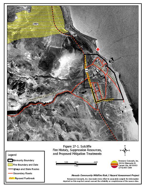
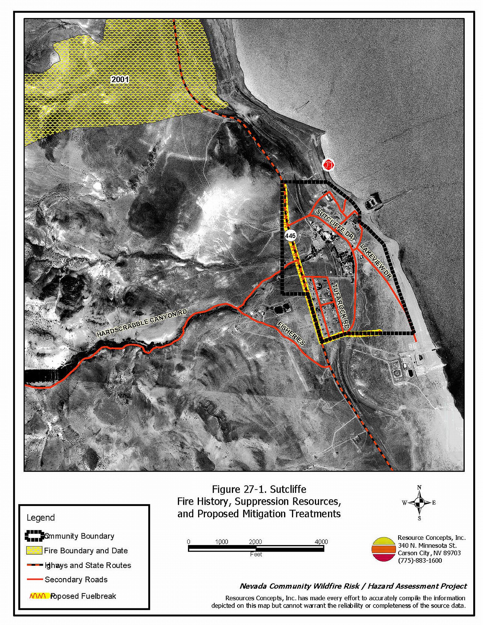
The Sutcliffe community is located within the Pyramid Lake Paiute Reservation, about forty miles northeast of Reno and twenty miles northeast of Nixon on State Route 445. Residences in the community are concentrated along the lower alluvial fan of the Virginia Range where Hardscrabble Creek terminates into Pyramid Lake. The residences extend approximately two miles north and south along State Route 445 and approximately 0.5 miles to the east and west of State Route 445. The Sutcliffe community boundary is shown in Figure 27-1. The SWCA assessment evaluated 81 structures and resulted in classifying the Sutcliffe community in the High Hazard category. A second inventory of the Sutcliffe community was not within the scope of this project. However upon completion of the community reconnaissance, the RCI Fire Specialists considered the overall community hazard to be in the Moderate Hazard category relative to other Washoe County Communities. Factors that contributed to the community hazard assessment were inadequate defensible space around residences, the potential for hazardous fire behavior, and moderate vegetative fuel loads within and surrounding the community.
27.1.1 Community Design
The Sutcliffe community is characterized by a classic wildland-urban interface condition. There is a clear line of demarcation between wildland fuels and residences in the community.
- Access: Access to Sutcliffe is limited to State Route 445, which is the only paved road into and out of the community. Sutcliffe Drive intersects with State Route 445 and is the main loop road through the community. There are several secondary streets and dirt roads in the community.
- Signage: Residential addresses and street signs are important to aid firefighting personnel in locating homes during low visibility conditions that occur during a wildland fire. SWCA observed less than adequate firesafe signage of both residences and streets within the community.
- Utilities: All utilities are above ground. Power lines have not been properly maintained in all areas of the community. Many of the residences also have propane tanks on their property.
27.1.2 Construction Materials
The majority of the homes (93 percent) in the community were built with class C rated wood siding, which burns in less than twenty minutes. The other structures (seven percent) are the six trailer houses with metal siding. Most of the wood-structured homes have standard pitched roofs with wood joists. Attic spaces are vented under eves with unscreened louvered vents. Many of the residences have been recently updated to Class B roofing materials (asphalt shingles).
27.1.3 Defensible Space
Most of the structures assessed (99 percent) in Sutcliffe do not have landscaping that meets the minimum defensible space requirement to help protect the home from damage or loss during a wildfire.
27.1.4 Suppression Capabilities
The Sutcliffe and Nixon Volunteer Fire Departments provide fire suppression services for the Sutcliffe community. The Sutcliffe Volunteer Fire Department is part of the Truckee Meadows Fire District. The closest resources that are available to respond to a reported wildland fire are summarized in Table 27-1. Reno Fire Department responds with additional resources from the closest available career staffed station according to their standard wildland fire dispatch. Other local, state, and federal resources are available upon request through mutual agreements as described in Section 4.1.1.
| Type of Resource | Amount of Equipment | Cooperating Partner (Resource Location) |
|---|---|---|
| Engine Type 3 Water Tender |
1 1 |
Sutcliffe Volunteer Fire Department (Truckee Meadows Station 41 - Sutcliffe) |
| Engine Type 3 Engine Type 4 |
1 1 |
Nixon Volunteer Fire Department (Nixon) |
| Source: SWCA 2003; Jerry Hunter of the Sutcliffe Volunteer Fire Department, and Roy Slate of the Reno Fire Department. | ||
Water Sources and Infrastructure
The community has a hydrant system with a 500 gallon per minute flow capacity. The community also has a water storage tank of 250,000 gallons that is replenished by a well equipped with an electric pump. Hydrants are located throughout the community and are gravity fed. Pyramid Lake can be used as a drafting and helicopter dip site.
Detection and Communication
Fires are reported in Washoe County through the 911 system, which connects the call with the Washoe County 911 Center. Washoe County 911 notifies the Sierra Front Interagency Dispatch Center of wildland fires. The Sierra Front Interagency Dispatch Center notifies the Volunteer Fire Departments, the Nevada Division of Forestry, the Bureau of Land Management, and the US Forest Service of fires through the use of pagers and radios.
Communication frequencies are currently compatible between agencies. When the federal agencies go to narrow band digital radios, the volunteers will no longer be able to communicate with the Bureau of Land Management and US Forest Service.
27.1.5 Factors Affecting Fire Behavior
Sutcliffe is located at the base of the alluvial fan on the east slope of the Virginia Range. The majority of the fuels within and around the community consists of sagebrush, rabbitbrush, cheatgrass, Indian ricegrass, needlegrass, and Sandberg bluegrass. Shrub height ranges from one to three feet. The fuel load is approximately four tons per acre and was considered a high hazard. The prevailing winds blow west to east and generally increase later in the day. These winds can be erratic in direction and velocity and can contribute to hazardous fire behavior.
27.1.6 Fire Behavior Worst-Case Scenario
The worst-case wildfire scenario for Sutcliffe would be a fire starting on a high hazard day, with multiple dry lightning strikes occurring upslope and west of the community. Strong down slope winds, greater than twenty miles per hour, would push the fire into the community. Homes and mobile homes with inadequate defensible space would be threatened. Existing brush within the community would be vulnerable to spot fire ignitions from firebrands. If the fire occurred during normal workday hours, volunteer response could be limited and the fire could escape initial attack capabilities before additional resources could arrive.
27.1.7 Ignition Risk Assessment
The ignition risk for the Sutcliffe community is high. There is a history of wildfire and fire ignitions within and around the community. North of town, the Warrior Fire burned across the highway and up to the lakeshore. Fires are common in the Virginia Range to the south and west of Sutcliffe. High ignition frequencies and risks are due to the tendency for lightning storms during the summer and moderate to high recreational use in the area.
27.2 Risk and Hazard Reduction Recommendations
The hazard reduction recommendations for Sutcliffe focus on improving defensible space Other recommendations pertain to community coordination efforts that could be initiated to enhance the fire safe nature of the Sutcliffe community. SWCA recommends additional fuel reduction treatments in the 2003 report.
27.2.1 Defensible Space Treatments
Defensible space treatments are an essential first line of defense for residential structures. The goal of the treatments is to significantly reduce or remove flammable vegetation within a prescribed distance from structures. (Refer to Appendix E for the recommended defensible space area). Defensible space reduces the fire intensity and improves firefighter and homeowner chances for successfully defending a structure against oncoming wildfire.
Property Owner and Tribal Resident Recommendations
- Remove, reduce, and replace vegetation to create defensible space around homes according to the guidelines in Appendix E. This area should be kept:
- Lean: There are only small amount of flammable vegetation.
- Clean: There is no accumulation of dead vegetation or other flammable debris.
- Green: Existing plants are healthy and green during the fire season.
- Store firewood a minimum distance of thirty feet from structures.
- Clear all dead plant material and combustible materials a minimum of five feet from the exterior of all structures.
- Mow or remove brush growing against fences in the community. The minimum distance for clearance should be ten feet in grass and 25 feet in brush.
- Enclose areas under wood decks and porches when possible or maintain these areas to be free of weeds and other flammable debris. Box in eves and cover ventilation openings with very fine metal wire mesh to prevent embers from entering the attic and crawl spaces.
- Clear all vegetation and combustible materials around propane tanks for a minimum of ten feet.
- Clear weeds and brush to a width of ten feet along both sides of the driveways.
- Maintain a minimum clearance of thirty feet from the crown of trees that remain within the defensible space zone. Keep this area free of smaller trees, shrubs, and other ladder fuels.
- Trim and remove tree branches a minimum of four feet from the ground to reduce ladder fuels on all deciduous and coniferous trees within the defensible space zone. Prune all dead and diseased branches.
- Prune all tree branches to a minimum distance of fifteen feet from buildings, paying special attention around chimneys.
- Mow grass within the defensible space zone to maintain a maximum height of four inches.
- Thin sagebrush and other shrubs to a spacing between shrubs that is equal to twice the shrub height.
- Immediately dispose of cleared vegetation when implementing defensible space treatments. This material dries quickly and poses a fire hazard if left on site.
- Where possible, irrigate all trees and large shrubs that remain in close proximity to structures to increase their fire resiliency. This is especially important during drought conditions.
- Install spark arrestors on chimneys.
- Maintain the defensible space as needed.
27.2.2 Fuels Reduction Treatments
Fuel reduction treatments are applied on a larger scale than defensible space treatments. Permanently changing the fuel characteristics over large blocks of land to one of a lower volume and altered distribution reduces the risk of a catastrophic wildfire in the treated area. Reducing vegetation along roadways and driveways could reduce the likelihood of blocking access and escape routes, help contain the fire perimeter, and improve firefighter access and safety for protecting homes.
Pyramid Lake Paiute Tribe and Bureau of Indian Affairs
- Construct and maintain a 150-foot wide and approximately one-mile long fuelbreak along the west side of State Route 445, between the water tank on the north side of the community and the intersection with Sutcliffe Road. Mow all vegetation to a height of four inches. Dispose of the biomass and reseeding with fire resistant species such as recommended in Appendix E, if necessary to control cheatgrass and noxious weeds.
- Construct and maintain a 150-foot wide fuelbreak on the south side of the community in an east/west direction, south of Sutcliffe and Fish Hatchery Roads. Mow all vegetation to a height of four inches. Dispose of the biomass and reseeding with fire resistant species such as recommended in Appendix E if necessary to control cheatgrass and noxious weeds.
Sutcliffe Volunteer Fire Department Recommendations
- Remove or mow vegetation within ten feet of all fire hydrants to improve visibility and access for fire personnel.
- Establish and promote a program for cleaning weeds and debris from around structures and fences in the community. Develop a biomass disposal program and a permit process for open burning.
Utility Company Recommendation
- Reduce and remove vegetation to maintain clearance around power lines. Clear vegetation within fifteen feet of utility poles near the community. Remove all trees from beneath power lines.
27.2.3 Fire Suppression Resources and Training
Sutcliffe Volunteer Fire Department and Bureau of Indian Affairs Recommendation
- Meet annually with the Bureau of Land Management to review pre-attack plans and to coordinate firefighting resources and response procedures including testing radio compatibility and coverage. Upgrade radios to new narrowband/digital technologies as needed to maintain communications with the federal agencies.
27.2.4 Community Coordination and Public Education
Many of the most effective activities aimed at reducing the threat of wildfire for the Sutcliffe community require that individual property owners coordinate with each other and with local fire authorities. Public education and awareness, neighbors helping neighbors, and proactive individuals setting examples for others to follow are just some of the approaches that will be necessary to meet the fire safe goals in the community.
Property Owner and Tribal Resident Recommendations
- Ensure that residential addresses are visible from the road. Address characters should be at least four inches high, reflective, and composed of non-flammable material. Improving visibility of addresses will make it easier for those unfamiliar with the area to navigate under smoky conditions caused by a wildland fire.
- Form a local chapter of the Nevada Fire Safe Council. The Nevada Fire Safe Council facilitates solutions to reduce the loss of lives and property from wildfire in Nevada’s communities. Through the establishment of a local Chapter, local communities will become part of a large network for sharing information including notification of programs and funding opportunities for fire mitigation projects such as those listed in this report. The Nevada Fire Safe Council will accept and manage grants and contracts on the Chapter’s behalf through its non-profit status. The Nevada Fire Safe Council will provide assistance and support to communities to complete fire safe plans, set priorities, educate and train community members, and promote success stories of its members. To form a local Chapter or for more information contact the:
Nevada Fire Safe Council
1187 Charles Drive
Reno, Nevada 89509
www.nvfsc.org
Pyramid Lake Paiute Tribe and Bureau of Indian Affairs
- Increase wildfire awareness through community newsletters, publications, meetings, and workshops. Distribute copies of the publication “Living with Fire” to all property owners. This publication is free of charge and copies can be requested from the University of Nevada Cooperative Extension.
- Coordinate with the Washoe County Assessor and the Washoe County Roads Department to ensure that all roads are named, mapped, identified with GPS coordinates, and included in the 911 database.
- Require all future development to meet the National Fire Codes with regard to community design, building construction and spacing, road construction and design, water supply, and emergency access. Refer to Appendix F for an example of fire safe recommendations for planning new developments.
- Facilitate coordinated and collaborative efforts at the Tribal, County and State levels for consistency in fire safe community planning and enforcement of fire safe ordinances in a unified manner.
27.3 Summary of Recommendations
| Involved Party | Recommended Treatment | Recommendation Description |
|---|---|---|
| Property Owners | Defensible Space | Remove, reduce, and replace vegetation around homes according to the defensible space guidelines in Appendix E. |
| Community Coordination | Install firesafe address signs that can be clearly read from the road. Form a local chapter of the Nevada Fire Safe Council. |
|
| Pyramid Lake Paiute Tribe Bureau of Indian Affairs |
Community Coordination | Increase wildfire issue awareness through community newsletters, publications, meetings, and workshops. Distribute copies of the publication “Living with Fire” to all property owners. Ensure that all new development roads are named, mapped, and identified with GPS locations. Require that all future development on the reservation meet the National Fire Codes. Facilitate coordinated and collaborative efforts at the Tribal, County and State levels for consistency in fire safe community planning and enforcement of fire safe ordinances in a unified manner. |
| Fuels Reduction | Construct and maintain a 200 foot wide fuelbreak to the west of Sutcliffe. Construct and maintain 150 foot wide fuelbreak south of Sutcliffe. |
|
| Sutcliffe Volunteer Fire Department Bureau of Indian Affairs |
Fuels Reduction | Clear vegetation within ten feet of all fire hydrants. Establish and promote a program for cleaning weeds and debris from around structures and fences in the community. Develop a biomass disposal program and a permit process for open burning. |
| Suppression and Training | Meet with Bureau of Land Management annually to discuss their pre-attack plan. | |
| Utility Company | Fuels Reduction | Remove trees and thin shrubs beneath power lines and utility poles. Maintain fifteen feet of clearance around utility poles. |
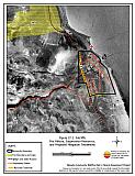
Figure 27-1Sutcliffe Fire History, Suppression Resources and Proposed Mitigation Treatments |
 |