![]()
![]()
28.0 Verdi
28.1 Risk and Hazard Assessment
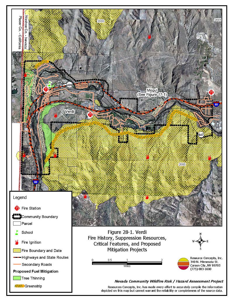
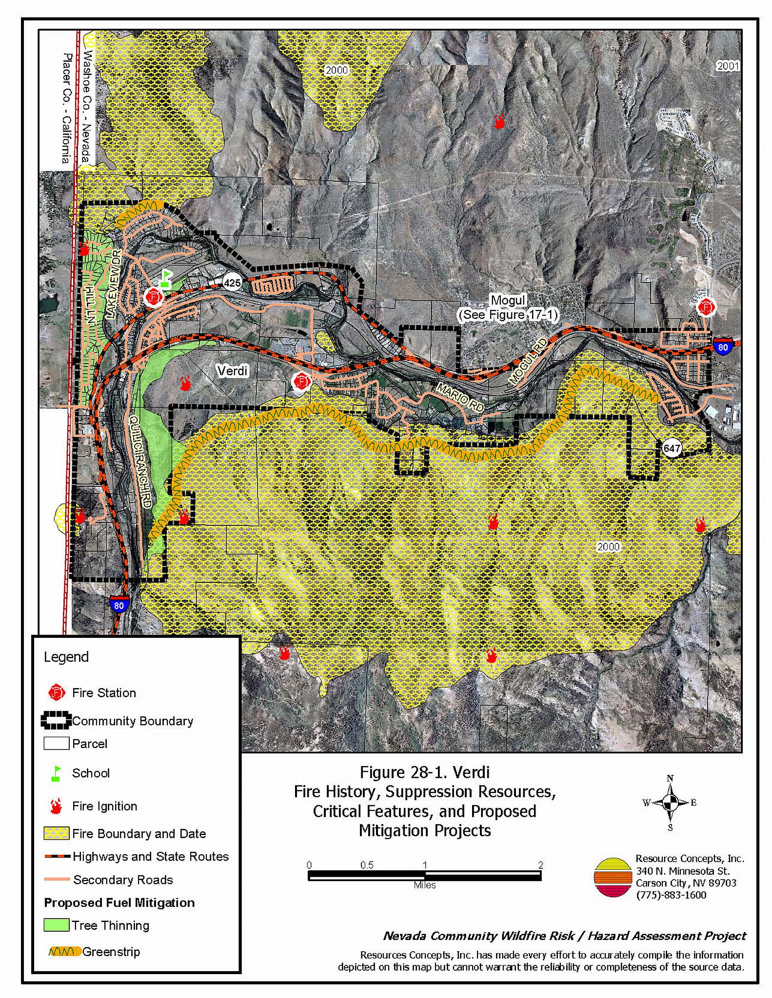
Verdi is located adjacent to the California state line west of Reno-Northwest along Interstate 80. The community is situated in the canyon between Peavine Peak and the northern extent of the Carson Range. The community boundary is shown in Figure 28-1. The community hazard assessment resulted in classifying Verdi in the Moderate Hazard Category (54 points). A summary of factors that contributed to the hazard rating is included in Table 28-3. Primary factors that determined the hazard rating in Verdi included the potential fire behavior based on fuel hazards and topographic conditions in the community.
28.1.1 Community Design
The wildland-urban interface area in Verdi is described as an intermix condition. There is no clear line of demarcation between wildland fuels and the residential structures in the community. Approximately sixty percent of residences are located on lots less than one acre in size and forty percent are located on lots between one and ten acres in size.
- Access: Bridge Street, South Verdi Road, and Quilici Ranch Road are the primary transportation routes providing access to and from the community. The roads are greater than 24 feet wide and provide adequate space for two-way vehicular travel and for fire suppression equipment to maneuver. Secondary roads in the majority of the community have road grades less than five percent with adequate turn around space for fire suppression apparatus.
- Signage: Almost all of the street signs in the community are easily visible. Ninety-six percent of the residential addresses are easily visible from the road. Clear and visible street signs and residential addresses are important in locating homes during low visibility conditions that occur during a wildfire.
- Utilities:All utilities are above ground. Power lines have not been properly maintained in all areas of the community. Proper maintenance minimizes the possibility that arcing may start fires in nearby vegetation. In some areas of the community, the recommended ten feet of vegetation clearance does not exist around propane tanks.
28.1.2 Construction Materials
Almost all of the homes in the interface are built with non-combustible or ignition resistant siding such as medium density fiberboard, stucco, or brick. Ninety-five percent of the residences have roofs of non-combustible material such as tile, metal, or composition. Approximately seventeen percent of the homes observed have unenclosed balconies, porches, decks, or other architectural features that can create drafty areas where sparks and embers can be trapped, smolder, ignite, and rapidly spread fire to the house.
28.1.3 Defensible Space
Approximately 93 percent of the homes surveyed in Verdi have landscaping that meets defensible space guidelines to protect the home from damage or loss during a wildfire.
28.1.4 Suppression Capabilities
Wildfire Protection Resources
The Verdi community is included in the Nevada Division of Forestry Sierra Forest Fire Protection District that includes Verdi Station 5, staffed by three career personnel daily with three additional seasonal firefighters during the fire season, and the Verdi Volunteer Fire Department Station 51. The Verdi VFD reported having 22 volunteer members at the time interviews were conducted for this project. Resources within the community for response to a reported wildland fire are summarized in Table 28-1. Reno Fire Department responds with additional resources from the closest available career staffed station according to their standard wildland fire dispatch. Other local, state, and federal resources are available upon request through mutual agreements as described in Section 4.1.1.
| Type of Resource | Amount of Equipment | Cooperating Partner (Resource Location) |
|---|---|---|
| Engine Type 3 Water Tender Type 1 |
2 1 |
Nevada Division of Forestry (Station 5 -Verdi) |
| Engine Type 3 Engine Type 4 Water Tender Type 1 |
2 1 1 |
Verdi Volunteer Fire Department (NDF Station 51 - Verdi) |
| Source: Brent Harper, Chief Verdi VFD, Joe Reinhardt ,BC, Nevada Division of Forestry; Marty Scheuerman DC, Reno Fire Department; Roy Slate Volunteer Coordinator Reno Fire Department. | ||
Water Sources and Infrastructure
Water available for fire suppression in Verdi includes fire hydrants with a minimum flow capacity of 1,000 gallons per minute within 1,000 feet of structures in parts of the community. The water system includes several storage tanks and operates by gravity and eclectic pumps. There are emergency back-up generators to refill water storage tanks in the case of a power outage. The Quilici Ranch Road area does not have hydrants.
Detection and Communication
Fires are reported in Washoe County through the 911 system, which connects the call with the Washoe County 911 Center. Washoe County 911 notifies the Sierra Front Interagency Dispatch Center of wildland fires. The Sierra Front Interagency Dispatch Center notifies the Volunteer Fire Departments, the Nevada Division of Forestry, the Bureau of Land Management, and the US Forest Service of fires through the use of pagers and radios.
Communication frequencies are currently compatible between agencies. When the federal agencies go to narrow band digital radios, the volunteers will no longer be able to communicate with the Bureau of Land Management and US Forest Service.
Fire Protection Personnel Qualifications
All volunteer firefighters are trained to the State Fire Marshal Entry Level Firefighter and Firefighter I standards. Nevada Division of Forestry provides all volunteer, career, and seasonal firefighters with Basic Wildland Firefighting training that meets NWCG 310-1 standards. Nevada Division of Forestry career firefighters also receive State Fire Marshal’s Firefighter I and II training
Work Load
The Verdi VFD responded to 114 calls in 2003 that included twenty wildland/brush calls.
Financial Support
Financial support for the Verdi VFD is provided through a pay-per-call program of the Nevada Division of Forestry Sierra Fire Protection District (NRS 473) and a contract with Sierra County, CA. Western Region Nevada Division of Forestry receives funding form the Sierra Fire District (NRS 473) and sales tax revenue.
28.1.5 Factors Affecting Fire Behavior
The community of Verdi is situated in the Truckee River canyon. The terrain varies from flat near the Truckee River to slopes between eight and twenty percent with all aspects. The prevailing wind direction is from the west and southwest. Strong down-canyon winds through the Truckee River canyon are common during summer afternoons.
Areas around Quilici Ranch Road, Hill Lane, and Garson Road are characterized by Jeffrey pine forest associated with mountain mahogany, bitterbrush, big sagebrush, and rabbitbrush. Cheatgrass, perennial grasses, pine needles, and pinecones are the primary ground fuels. The fuel loads in the forested areas within and around the community were estimated to range between six and eighteen tons per acre depending upon the slope and the tree and shrub density. The fuel hazard was considered moderate to extreme. The heaviest fuel loadings occur on interior lots.
28.1.6 Fire Behavior Worst-Case Scenario
The worst-case scenario for this area would be a dry lightning storm late on a summer afternoon, during a year with above normal precipitation and abundant cheatgrass production. Multiple fire ignitions combined with strong erratic winds, greater than twenty miles per hour, could push fires into the community from the southwest and north. Prevailing west winds in the Truckee River canyon would slow fire spread from the east. Hazardous fuels in the interior of the community characterized by dense brush, overstocked stands of timber, and thick stands of mountain mahogany are be vulnerable to long range fire brand ignitions and increase the potential for spot fires within the community. These interior areas of the community are at risk for structure loss from spot fires.
The distribution of two state-listed noxious weeds, tall whitetop and yellow star thistle, are already present in the community and could expand into burned areas.
28.1.7 Ignition Risk Assessment
The ignition risk in Verdi is high due to the tendency for summer afternoon thunderstorms and the high public use of the area. The area has a history of multiple ignitions and large fires.
28.2 Risk and Hazard Reduction Recommendations
The responsibility to keep a community fire safe falls not only on the local fire protection district but also on the residents of the community and local governments. The recommendations for the Verdi area focus on fuel reduction treatments aimed at thinning trees, and reducing brushy ladder fuels, and the implementation of other defensible space treatments around private residences.
28.2.1 Defensible Space Treatments
Defensible space treatments are an essential first line of defense for residential structures. The goal of the treatments is to significantly reduce or remove flammable vegetation within a prescribed distance from structures. (Refer to Appendix E for the recommended defensible space area). Defensible space reduces the fire intensity and improves firefighter and homeowner chances for successfully defending a structure against oncoming wildfire.
Property Owner Recommendations
- Remove, reduce, and replace vegetation to create defensible space around homes according to the guidelines in Appendix E. This area should be kept:
- Lean: There are only small amount of flammable vegetation.
- Clean: There is no accumulation of dead vegetation or other flammable debris.
- Green: Existing plants are healthy and green during the fire season.
- Store firewood a minimum distance of thirty feet from structures.
- Clear all dead plant material and combustible materials a minimum of five feet from the exterior of all structures.
- Mow or remove brush growing against fences in the community. The minimum distance for clearance should be ten feet in grass and 25 feet in brush.
- Enclose areas under wood decks and porches when possible or maintain these areas to be free of weeds and other flammable debris. Box in eves and cover ventilation openings with very fine metal wire mesh to prevent embers from entering the attic and crawl spaces.
- Clear all vegetation and combustible materials around propane tanks for a minimum of ten feet.
- Clear weeds and brush to a width of ten feet along both sides of the driveways.
- Maintain a minimum clearance of thirty feet from the crown of trees that remain within the defensible space zone. Keep this area free of smaller trees, shrubs, and other ladder fuels.
- Trim and remove tree branches a minimum of fifteen feet from the ground, but not more than one-third the height of the tree, to reduce ladder fuels on all deciduous and coniferous trees within the defensible space zone. Prune all dead and diseased branches.
- Prune all tree branches to a minimum distance of fifteen feet from buildings, paying special attention around chimneys.
- Install spark arrestors on chimneys.
- Replace wood shake roofs with fire resistant roofing materials.
- Mow grass within the defensible space zone to maintain a maximum height of four inches.
- Thin sagebrush and other shrubs to a spacing between shrubs that is equal to twice the shrub height.
- Replace ornamental junipers in landscaped areas with fire resistant species.
- Immediately dispose of cleared vegetation when implementing defensible space treatments. This material dries quickly and poses a fire hazard if left on site.
- Where possible, irrigate all trees and large shrubs that remain in close proximity to structures to increase their fire resiliency. This is especially important during drought conditions.
- Where cheatgrass has become dominant within the defensible space zone, areas should be mowed prior to seed maturity or treated with an application of a pre-emergent herbicide.[17] Treatments may need to be repeated for several years to ensure that the seed bank of unwanted annual grass seeds has been depleted. Refer to Appendix E for a recommended seed mixture and planting guidelines that can be used in conjunction with cheatgrass removal.
- Maintain the defensible space as needed.
28.2.2 Fuel Reduction Treatments
Fuel reduction treatments are applied on a larger scale than defensible space treatments. Permanently changing the fuel characteristics over large blocks of land to one of a lower volume and altered distribution reduces the risk of a catastrophic wildfire in the treated area. Reducing vegetation along roadways and driveways could reduce the likelihood of blocking access and escape routes, help contain the fire perimeter, and improve firefighter access and safety for protecting homes.
Utility Company Recommendation
- Reduce and remove vegetation to maintain clearance around power lines. Clear vegetation within fifteen feet of utility poles near the community. Remove all trees from under power lines. Reduce and remove vegetation to maintain a minimum clearance of thirty feet from fences around power substations.
Washoe County Roads Department and Nevada Department of Transportation Recommendation
- Reduce vegetation and maintain roads by mowing all vegetation to a height of no more than four inches for a distance of twenty feet from the edge of the pavement on both sides of the road. Remove biomass and dispose at an appropriate site. Reseed treated areas with fire resistant species such as recommended in Appendix E to minimize cheatgrass and noxious weed invasion.
Union Pacific Railroad Recommendation
- Mow or reduce vegetation within a minimum distance of twenty feet on both sides of the railroad tracks. Reseed according to the recommendations in Appendix E, if necessary to prevent cheatgrass or other noxious weed invasion. Maintain low growing, low-density fuel volumes within the railroad corridors to reduce the wildfire ignition risk and hazard.
US Forest Service and Property Owner Recommendation
- Construct a greenstrip 100 to 200 feet wide seeded with crested wheatgrass adjacent to structures in burned areas around the community as shown in Figure 28-1.
- Thin Jeffrey pine trees to a basal area of 80 to 100 square feet per acre. Remove ladder fuels in the understory along both sides of the Truckee River. Refer to Appendix E for basal area thinning guidelines.
28.2.3 Fire Suppression Resources and Training
Verdi Volunteer Fire Department and Nevada Division of Forestry Recommendation
- Meet annually with the US Forest Service to review pre-attack plans and to coordinate firefighting resources and response procedures including testing radio compatibility and coverage. Upgrade radios to new narrowband/digital technologies as needed to maintain communications with the federal agencies.
28.2.4 Community Coordination
Property Owners
- Form a local chapter of the Nevada Fire Safe Council. The Nevada Fire Safe Council facilitates solutions to reduce the loss of lives and property from wildfire in Nevada’s communities. Through the establishment of a local Chapter, local communities will become part of a large network for sharing information including notification of programs and funding opportunities for fire mitigation projects such as those listed in this report. The Nevada Fire Safe Council will accept and manage grants and contracts on the Chapter’s behalf through its non-profit status. The Nevada Fire Safe Council will provide assistance and support to communities to complete fire safe plans, set priorities, educate and train community members, and promote success stories of its members. To form a local Chapter or for more information contact the:
Nevada Fire Safe Council
1187 Charles Drive
Reno, Nevada 89509
www.nvfsc.org - Assure that address signs are visible from the road. Address characters should be at least four inches high, reflective, and composed of non-flammable material. Improving visibility of addresses will make it easier for those unfamiliar with the area to navigate under smoky conditions during a wildland fire.
Washoe County Recommendations
- Continue to require all future development in the County to meet the National Fire Codes with regard to community design, building construction and spacing, road construction and design, water supply, and emergency access. Refer to Appendix F for an example of fire safe recommendations for planning new developments.
- Develop and enforce ordinances regarding fuel reduction and defensible space requirements for wildland-urban interface areas. Require defensible space implementation and maintenance on all developed lots and fuel reduction on all vacant lots within the interface area. Require approval by the appropriate fire agency of completed fuel reduction treatments prior to issuance of building permits for new wildland-urban interface developments.
- Facilitate coordinated and collaborative efforts at the County and State levels for consistency in fire safe community planning and enforcement of fire safe ordinances in a unified manner.
Nevada Division of Forestry and Verdi Volunteer Fire Department
- Prepare an evacuation plan and post or otherwise distribute this plan to residents. This plan should include information regarding evacuation routes, evacuation procedures, designated fire safe zones, and procedures for sheltering in place in case evacuation becomes infeasible during a fast moving firestorm.
28.2.5 Public Education
A public education program that explains fire safe measures in clear and emphatic terms will have an impact on residents of the wildland-urban interface. Informed community members will be more inclined to make efforts to effectively reduce wildfire hazards around their homes and neighborhoods.
Nevada Division of Forestry and Verdi Volunteer Fire Department
- Distribute copies of the publication “Living with Fire” to all property owners. This publication is free of charge. Copies can be requested from the University of Nevada Cooperative Extension.
Property Owner Recommendation
- As an evacuation plan becomes available, citizens should read and become fully knowledgeable of evacuation procedures, fire safety zones, and safety procedures for sheltering in place in the event that evacuation is not possible.
28.3 Summary of Recommendations
| Involved Party | Recommended Treatment | Recommendation Description |
|---|---|---|
| Property Owners | Defensible Space | Remove, reduce, and replace vegetation around homes according to the defensible space guidelines in Appendix E. |
| Community Coordination | Form a local chapter of the Nevada Fire Safe Council. Improve address visibility from the road. Participate in public education opportunities and become knowledgeable of emergency evacuation procedures. |
|
| Fuels Reduction | Coordinate with US Forest Service to create a crested wheatgrass greenstrip in burned areas adjacent to structures. Thin trees to a basal area of 80-100 square feet per acre and remove ladder fuels on both sides of the Truckee River. |
|
| Washoe County Nevada Department of Transportation |
Fuels Reduction | Reduce and remove vegetation in road right-of-ways to maintain an average four-inch vegetation height. Reseed treated areas to minimize cheatgrass and noxious weed invasion. |
| Union Pacific Railroad | Fuels Reduction | Reduce and remove vegetation within twenty feet on both sides of railroad tracks. |
| Utility Company | Fuels Reduction | Remove trees and thin shrubs beneath power lines and utility poles. Maintain fifteen feet of clearance around utility poles. |
| Washoe County | Community Coordination | Continue to require all future development in the County to meet the national fire codes with regard to community design, building construction, road construction, water supply, and emergency access. Develop and/or enforce laws and regulations for defensible space and fuels reduction that include absentee homeowners, vacant lots, and new subdivisions. Facilitate coordinated and collaborative efforts at the County and State levels for consistency in fire safe community planning and enforcement of fire safe ordinances in a unified manner. |
| Nevada Division of Forestry Verdi Volunteer Fire Department |
Resources and Training | Meet annually with the US Forest Service to discuss pre-attack plans for the community and test radio compatibility. |
| Community Coordination | Develop an emergency evacuation plan for Verdi area. | |
| Public Education | Distribute copies of the publication “Living with Fire” to all property owners. | |
| US Forest Service | Fuels Reduction | Coordinate with property owners to construct a crested wheatgrass greenstrip in burned areas adjacent to structures. Thin trees to a basal area of 80-100 square feet per acre and remove ladder fuels on both sides of the Truckee River. |
Table 28-3Verdi Wildfire Hazard Rating Summary |
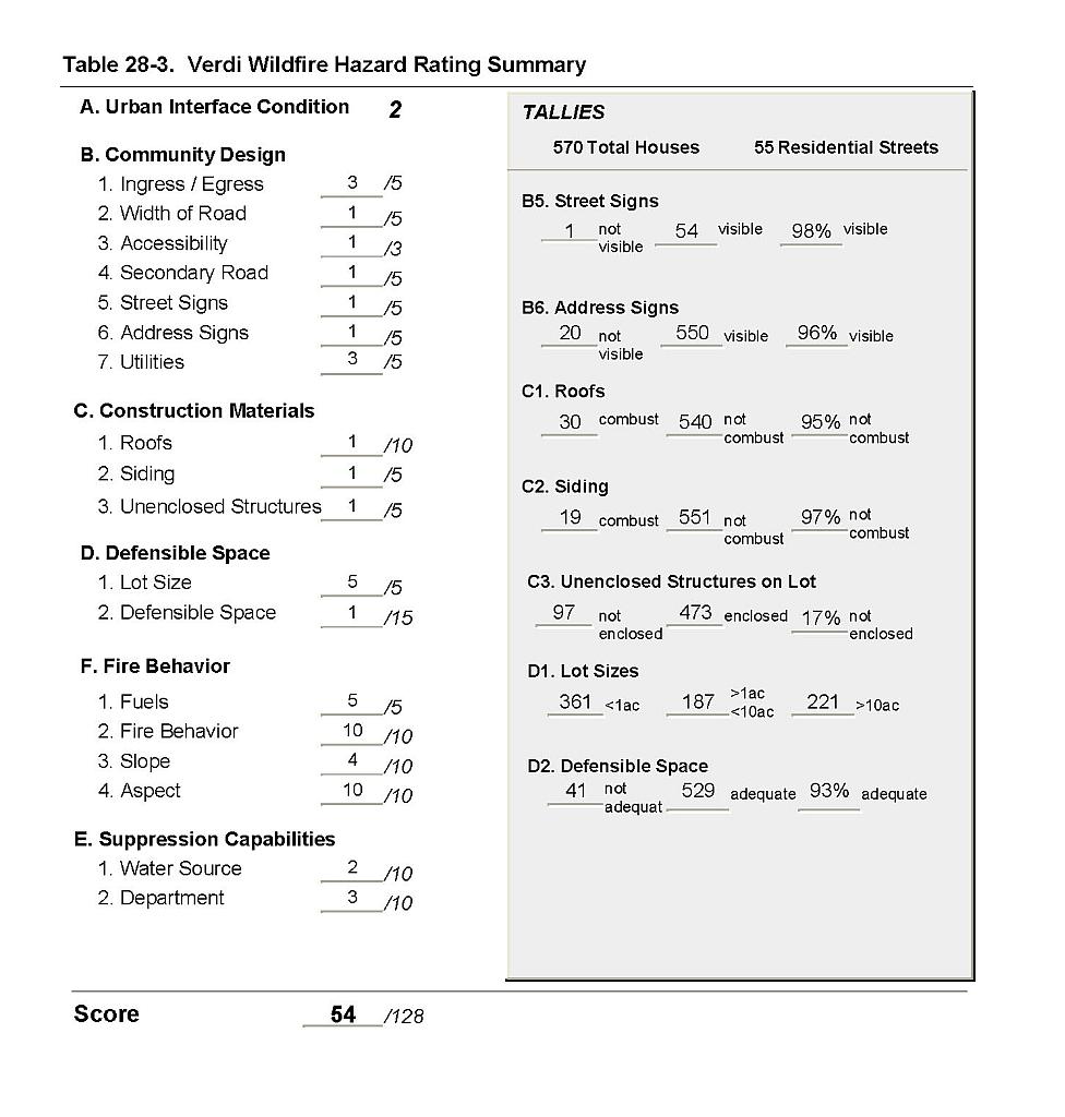 |
Figure 28-1Verdi Fire History, Suppression Resources, Critical Features, and Proposed Mitigation Projects |
 |