![]()
![]()
31.0 Empire
31.1 Risk and Hazard Assessment
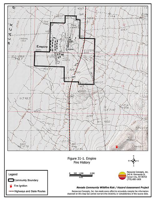
Empire is located approximately fifty miles north of Nixon (95 miles northeast of Sparks) and five miles south of Gerlach along State Route 447. The community is situated in the Black Rock Desert and the toe of the west-facing slopes of the Selenite Range. The community boundary is shown in Figure 31-1. The community hazard assessment resulted in classifying Empire in the Low Hazard Category (38 points). A summary of factors that contributed to the hazard rating is included in Table 31-3. Primary factors that determined the hazard rating in Empire include the low hazard fuel loads and limited fire suppression resources.
31.1.1 Community Design
The wildland-urban interface area in Empire is characterized as an intermix condition where there is no clear line of demarcation between wildland fuels and the residential structures in the community. Most of the residences in the community are located on lots between one and ten acres in size.
- Access: State Route 447 is the primary transportation route providing access to and from the community. The road is greater than 24 feet wide and provides adequate space for two-way vehicular travel and for fire suppression equipment to maneuver. Secondary roads in the majority of the community have road grades less than five percent with adequate turn around areas for fire suppression apparatus.
- Signage: All of the street signs in the community are easily visible. Approximately 85 percent of the residential addresses are easily visible from the road. Clear and visible street signs and residential addresses are important in locating homes during low visibility conditions that occur during a wildfire.
- Utilities: All utilities are above ground. Power lines have not been properly maintained in all areas of the community. Proper maintenance minimizes the possibility that arcing may start fires in nearby vegetation. In some areas of the community, the recommended ten feet of vegetation clearance does not exist around propane tanks.
31.1.2 Construction Materials
Almost all of the homes in the interface are built with non-combustible or ignition resistant siding such as medium density fiberboard, stucco, or brick. All of the residences have roofs of non-combustible material such as tile, metal, or composition. Approximately eleven percent of the homes observed had unenclosed balconies, porches, decks, or other architectural features that create drafty areas where sparks and embers can be trapped, smolder, ignite, and rapidly spread fire to the house.
31.1.3 Defensible Space
All of the homes surveyed in Empire have landscaping that meets defensible space guidelines to protect the home from damage or loss during a wildfire.
31.1.4 Suppression Capabilities
Wildfire Protection Resources
There are no fire department or suppression resources in the community of Empire. The closest fire resources would respond from the Gerlach Volunteer Fire Department as summarized in Table 31-1. Reno Fire Department responds with additional resources from the closest available career staffed station according to their standard wildland fire dispatch. Other local, state, and federal resources are available upon request through mutual agreements as described in Section 4.1.1.
| Type of Resource | Amount of Equipment | Cooperating Partner (Resource Location) |
|---|---|---|
| Engine Type 2 Engine Type 4 Water Tender 4,000 gals. |
1 1 1 |
Gerlach Volunteer Fire Department (Truckee Meadows Station 42) |
| Source: Bill Gooch, Fire Chief Gerlach VFD | ||
Detection and Communication
Fires are reported in Washoe County through the 911 system, which connects the call with the Washoe County 911 Center. Washoe County 911 notifies the Sierra Front Interagency Dispatch Center of wildland fires. The Sierra Front Interagency Dispatch Center notifies the Volunteer Fire Departments, the Nevada Division of Forestry, the Bureau of Land Management, and the US Forest Service of fires through the use of pagers and radios.
Communication frequencies are currently compatible between agencies. When the federal agencies go to narrow band digital radios, the volunteers will no longer be able to communicate with the Bureau of Land Management and US Forest Service.
Water Sources and Infrastructure
Empire has fire hydrants in some areas of the community. The hydrants are gravity fed from a community water storage tank that is filled using an electric pump. There is no emergency backup generator. There are two additional water tanks at the USG drywall factory, which is located within the community boundary. The estimated round trip time, from areas without hydrants, to additional water supplies to refill fire apparatus is approximately twenty minutes away.
Community Preparedness
Empire is included in the Washoe County All-Risk Emergency Plan.
31.1.5 Factors Affecting Fire Behavior
The terrain around Empire is mostly flat (less than eight percent slopes) with a slight west facing aspect. The prevailing wind direction is from the south or southwest. On the north, east, and south sides of the community the vegetation consists of winterfat, sagebrush, horsebrush, shadscale, bud sagebrush, and greasewood. The shrubs are generally one to two feet in height. The fuel load was estimated at one ton per acre and was considered a low fuel hazard. On the west side of the community greasewood, shadscale, horsebrush, and budsage are the dominant species. The shrubs in this area are generally two to four feet tall with moderate density levels. The fuel load in this area was estimated at two tons per acre and considered a moderate fuel hazard.
31.1.6 Fire Behavior Worst-Case Scenario
The worst-case scenario would be a fire starting along the northwest corner of the community with wind from the northwest pushing the fire through the landing strip area and into the northwest part of the community. The threat to homes would be low due to existing defensible space. Tumbleweed accumulations in the community could cause increased fire spread and spot fires within the community.
31.1.7 Ignition Risk Assessment
The community of Empire has a moderate ignition risk due to the sparse fuels around the community, and the low population density in the area. There is a history of fire in the area. The primary ignition source is lightning. Moderate highway traffic along the east side of the community is an additional risk.
31.2 Risk and Hazard Reduction Recommendations
The responsibility to keep a community fire safe falls not only on the local fire protection district but also on the residents of the community, businesses, and local governments.
31.2.1 Defensible Space Treatments
Defensible space treatments are an essential first line of defense for residential structures. The goal of the treatments is to significantly reduce or remove flammable vegetation within a prescribed distance from structures. (Refer to Appendix E for the recommended defensible space area). Defensible space reduces the fire intensity and improves firefighter and homeowner chances for successfully defending a structure against oncoming wildfire.
Property Owner Recommendations
- Remove, reduce, and replace vegetation to create defensible space around homes according to the guidelines in Appendix E. This area should be kept:
- Lean: There are only small amount of flammable vegetation.
- Clean: There is no accumulation of dead vegetation or other flammable debris.
- Green: Existing plants are healthy and green during the fire season.
- Store firewood a minimum distance of thirty feet from structures.
- Mow or remove brush growing against fences in the community. The minimum distance for clearance should be ten feet in grass and 25 feet in brush.
- Enclose areas under wood decks and porches when possible or maintain these areas to be free of weeds and other flammable debris. Box in eves and cover ventilation openings with very fine metal wire mesh to prevent embers from entering the attic and crawl spaces.
- Clear all vegetation and combustible materials around propane tanks for a minimum of ten feet.
- Thin sagebrush and other shrubs to a spacing between shrubs that is equal to twice the shrub height.
- Remove debris and flammable materials (tumbleweeds) from within the defensible space area.
- Immediately dispose of cleared vegetation when implementing defensible space treatments. This material dries quickly and poses a fire hazard if left on site.
- Where possible, irrigate all trees and large shrubs that remain in close proximity to structures to increase their fire resiliency. This is especially important during drought conditions.
- Maintain the defensible space as needed.
31.2.2 Fuels Reduction Treatments
Fuel reduction treatments are applied on a larger scale than defensible space treatments. Permanently changing the fuel characteristics over large blocks of land to one of a lower volume and altered distribution reduces the risk of a catastrophic wildfire in the treated area. Reducing vegetation along roadways and driveways could reduce the likelihood of blocking access and escape routes, help contain the fire perimeter, and improve firefighter access and safety for protecting homes.
Utility Company Recommendation
- Reduce and remove vegetation to maintain clearance around power lines. Clear vegetation within fifteen feet of utility poles near the community. Remove all trees from beneath power lines.
31.2.3 Community Coordination
Property Owner Recommendation
- Ensure that residential addresses are visible from the road. Address characters should be at least four inches high, reflective, and composed of non-flammable material. Improving visibility of addresses will make it easier for those unfamiliar with the area to navigate under smoky conditions caused by a wildland fire.
Washoe County Recommendations
- Continue to require all future development in the County to meet the National Fire Codes with regard to community design, building construction and spacing, road construction and design, water supply, and emergency access. Refer to Appendix F for an example of fire safe recommendations for planning new developments.
- Facilitate coordinated and collaborative efforts at the County and State levels for consistency in fire safe community planning and enforcement of fire safe ordinances in a unified manner.
31.2.4 Public Education
A public education program that explains fire safe measures in clear and emphatic terms will have an impact on residents of the wildland-urban interface. Informed community members will be more inclined to make efforts to effectively reduce wildfire hazards around their homes and neighborhoods.
Gerlach Volunteer Fire Department
- Distribute copies of the publication “Living with Fire” to all property owners. This publication is free of charge. Copies can be requested from the University of Nevada Cooperative Extension.
31.3 Summary of Recommendations
| Involved Party | Recommended Treatment | Recommendation Description |
|---|---|---|
| Property Owners |
Defensible Space Treatments | Remove, reduce, and replace vegetation around homes according to the defensible space guidelines in Appendix E. |
| Community Coordination | Assure that residential addresses are visible from the road. | |
| Utility Company | Fuels Reduction | Reduce and maintain vegetation in power line corridors. Maintain fifteen feet of clearance around utility poles. |
| Washoe County | Community Coordination | Continue to require all future development in the County to meet the National Fire Codes with regard to community design, building construction and spacing, road construction, water supply, and emergency access. Facilitate coordinated and collaborative efforts at the County and State levels for consistency in fire safe community planning and enforcement of fire safe ordinances in a unified manner. |
| Gerlach Volunteer Fire Department | Public Education | Distribute copies of the publication “Living with Fire” to all property owners. |
Table 31-3Empire Wildfire Hazard Rating Summary |
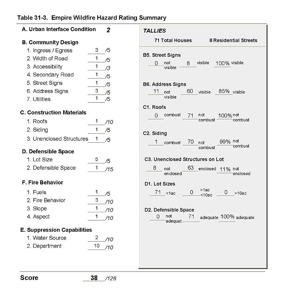 |
Figure 31-1Empire Fire History |
 |