![]()
![]()
33.0 Sparks (Reno - Northeast)
33.1 Risk and Hazard Assessment
The City of Sparks is located generally east of US Highway 395, north of the Truckee River, and south of the Sun Valley and Spanish Springs communities. The community is situated in the valley bottom of the Truckee Meadows and adjacent to the west-facing slopes of Canoe Hill and the Pah Rah Range.
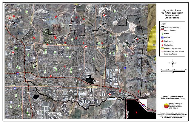
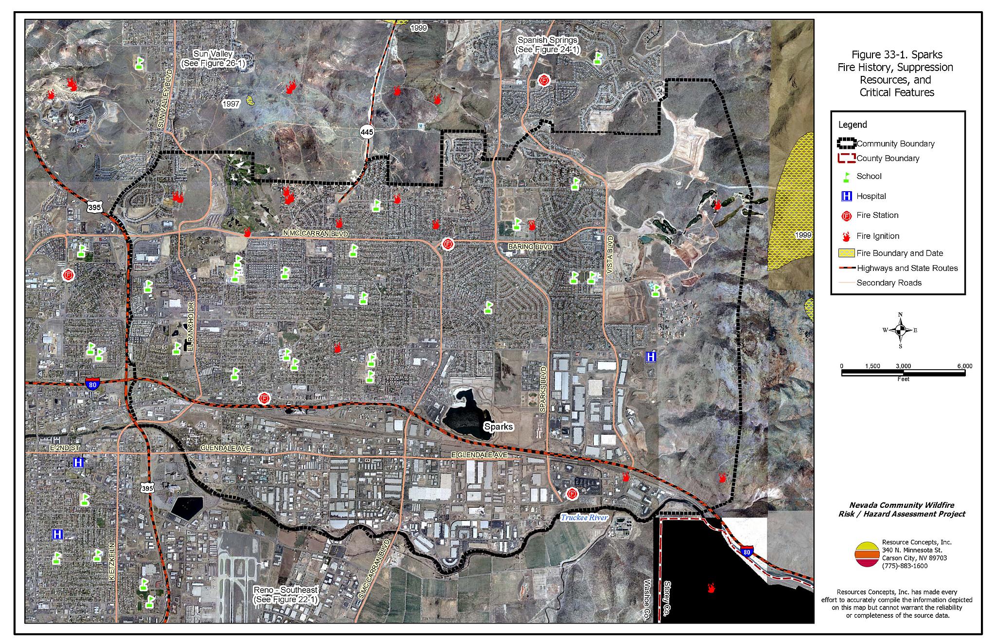
The Sparks community boundary is shown in Figure 33-1. The community boundary encompasses geographically diverse conditions, varied fuel conditions, and a wide range of urban development styles. The results reported for this project represent a general overview of the entire urban-interface condition. The community hazard assessment resulted in classifying Sparks in the Low Hazard Category (40 points). A summary of factors that contributed to the hazard rating is included in Table 33-3. Primary factors that determined the hazard rating in Sparks included the high availability of career-level fire suppression resources throughout the community, adequate access and address signage throughout the community, and the high number of homes constructed with flame-resistant materials.
Portions of Sparks are rapidly expanding and community boundaries shown in this report will need to be updated on a regular basis. More detailed analyses of smaller neighborhoods within the communities could better reflect community risk and hazard conditions at the local level.
33.1.1 Community Design
The wildland-urban interface area in Sparks is characterized as the classic interface condition. There is a clear line of demarcation between wildland fuels and the residential structures in the community. Most of the residences are located on lots less than one acre in size.
- Access: US Highway 395, Interstate 80, McCarran Boulevard, Sparks and Vista Boulevards are some of the primary transportation routes providing access to and from the community. The roads are greater than 24 feet wide and provide adequate space for two-way vehicular travel and for fire suppression equipment to maneuver.
- Signage: All of the street signs in the community are easily visible. Ninety-five percent of the residential addresses are easily visible from the road. Clear and visible street signs and residential addresses are important in locating homes during low visibility conditions that occur during a wildfire.
- Utilities: Utilities are both above ground and below ground. Power lines have been properly maintained in all areas of the community. Proper maintenance minimizes the possibility that arcing may start fires in nearby vegetation.
33.1.2 Construction Materials
Almost all of the homes in the interface are built with non-combustible or ignition resistant siding such as medium density fiberboard, stucco, or brick. Ninety-five percent of the homes have roofs of non-combustible material such as tile, metal, or composition. Approximately seven percent of the homes observed have unenclosed balconies, porches, decks, or other architectural features that create drafty areas where sparks and embers can be trapped, smolder, ignite, and rapidly spread fire to the house.
33.1.3 Defensible Space
Approximately 77 percent of the homes surveyed in the City of Sparks have landscaping that meets defensible space guidelines to protect the home from damage or loss during a wildfire.
33.1.4 Suppression Capabilities
Wildfire Protection Resources
The Sparks Fire Department provides fire suppression resources for the City of Sparks fire protection. The Department has four fire stations, with a fifth station due to open in May 2005. The standard Sparks Fire Department dispatch for a wildland fire is shown in Table 33-1. Reno Fire Department assists with additional resources from the closest available career staffed station according to their standard wildland fire dispatch. Other local, state, and federal resources are available upon request through mutual agreements as described in Section 4.1.1.
| Type of Resource | Amount of Equipment | Cooperating Partner (Resource Location) |
|---|---|---|
| Engine Type 3 Engine Type 1 Truck Water Tender Battalion Chief |
2 2 1 1 1 |
Spark Fire Department (Closest available resources) |
| Source: Andy Flock, Sparks Fire Department | ||
Detection and Communication
Fires are reported in Washoe County through the 911 system. The City of Sparks Fire Department resources are dispatched through Sparks Police and Fire Dispatch in Sparks. The Reno Fire Department is dispatched through Reno Dispatch in Reno. Washoe County 911 notifies the Sierra Front Interagency Dispatch Center of wildland fires. The Sierra Front Interagency Dispatch Center notifies the Volunteer Fire Departments, the Nevada Division of Forestry, the Bureau of Land Management, and the US Forest Service of fires through the use of pagers and radios.
Communication frequencies are currently compatible between agencies. When the federal agencies go to narrow band digital radios, the Sparks Fire Department may no longer be able to communicate with the Bureau of Land Management and US Forest Service.
Water Sources and Infrastructure
The City of Sparks has fire hydrants with a minimum flow capacity of 500 gallon per minute within 500 feet of structures. The hydrant system is gravity fed and supplied by several water storage tanks. They system has an emergency diesel generator backup power source to refill tanks during a power outage. The Marina Lake and several golf course ponds within the city can be used as helicopter dip-sites.
Fire Protection Personnel Qualifications
All members of the Sparks Fire Department meet the NWCG 310-1 requirements for wildland fire training. They are required to complete the forty-hour basic wildland firefighting course and attend an eight-hour refresher course annually. All Captains are trained to the level of Engine Boss, and all Battalion Chiefs are trained to the level of Strike Team Leader. The red card system is used for individual certification.
Financial Support
The Sparks Fire Department is funded through the City of Sparks General Fund.
Community Preparedness
The City of Sparks has an All-Risk Emergency Operations Plan. The last update was in 1998 with the intentions of incorporating the recommendations from this report into the City plan. The community is also included in the Washoe County All-Risk Emergency Plan.
33.1.5 Factors Affecting Fire Behavior
The terrain along the wildland-urban interface areas of Sparks is generally flat with west-facing hillsides east of the community. Slopes generally range between twenty and thirty percent in these hilly areas. The prevailing wind direction is from the south and southwest and high wind speeds are common during summer afternoons.
In the unburned areas on the east side of the city, the vegetative fuels consist of big sagebrush, rabbitbrush, Mormon tea, and greasewood. Cheatgrass, bottlebrush squirreltail, and Russian thistle occupy the interspaces between shrubs. In this vegetation type the fuel load was estimated at two tons per acre and was considered a moderate fuel hazard. In the burned areas on the east side of Sparks, the fuel load was estimated at less than one ton per acre and was considered a low fuel hazard.
33.1.6 Fire Behavior Worst-Case Scenario
The worst-case wildfire scenario for Sparks would be a wind-driven fire starting on the north side of Interstate 80, east of Sparks. On a high hazard day with a south-southwest winds greater than twenty miles per hour, the fire would be wind and threaten custom and track homes located on the west facing slopes.
33.1.7 Ignition Risk Assessment
The ignition risk within the wildland-urban interface area around the City of Sparks is low. There is a history of wildland fires and the area is prone to summer lightning activity. The ignition risk would be greater during years with high cheatgrass growth.
33.2 Risk and Hazard Reduction Recommendations
The responsibility to keep a community fire safe falls not only on the local fire protection district but also on the residents of the community, businesses, and local governments. The hazard reduction recommendations for the City of Sparks focus on maintaining defensible space.
33.2.1 Defensible Space Treatments
Defensible space treatments are an essential first line of defense for residential structures. The goal of the treatments is to significantly reduce or remove flammable vegetation within a prescribed distance from structures. (Refer to Appendix E for the recommended defensible space area). Defensible space reduces the fire intensity and improves firefighter and homeowner chances for successfully defending a structure against oncoming wildfire.
Property Owner Recommendations
- Remove, reduce, and replace vegetation to create defensible space around homes according to the guidelines in Appendix E. This area should be kept:
- Lean: There are only small amount of flammable vegetation.
- Clean: There is no accumulation of dead vegetation or other flammable debris.
- Green: Existing plants are healthy and green during the fire season.
- Store firewood a minimum distance of thirty feet from structures.
- Mow or remove brush growing against fences in the community. The minimum distance for clearance should be ten feet in grass and 25 feet in brush.
- Enclose areas under wood decks and porches when possible or maintain these areas to be free of weeds and other flammable debris. Box in eves and cover ventilation openings with very fine metal wire mesh to prevent embers from entering the attic and crawl spaces.
- Clear all vegetation and combustible materials around propane tanks for a minimum of ten feet.
- Clear weeds and brush to a width of ten feet along both sides of the driveways.
- Trim and remove tree branches a minimum of four feet from the ground to reduce ladder fuels on all deciduous and coniferous trees within the defensible space zone. Prune all dead and diseased branches.
- Prune all tree branches to a minimum distance of fifteen feet from buildings, paying special attention around chimneys.
- Install spark arrestors on chimneys.
- Mow grass within the defensible space zone to maintain a maximum height of four inches.
- Immediately dispose of cleared vegetation when implementing defensible space treatments. This material dries quickly and poses a fire hazard if left on site.
- Where possible, irrigate all trees and large shrubs that remain in close proximity to structures to increase their fire resiliency. This is especially important during drought conditions.
- Maintain the defensible space as needed.
- Remove debris and flammable materials within defensible space.
33.2.2 Fuels Reduction Treatments
Fuel reduction treatments are applied on a larger scale than defensible space treatments. Permanently changing the fuel characteristics over large blocks of land to one of a lower volume and altered distribution reduces the risk of a catastrophic wildfire in the treated area. Reducing vegetation along roadways and driveways could reduce the likelihood of blocking access and escape routes, help contain the fire perimeter, and improve firefighter access and safety for protecting homes.
Sparks Fire Department Recommendation
- Develop and enforce brush clearance and biomass disposal programs.
33.2.3 Fire Suppression Resources and Training
Sparks Fire Department Recommendation
- Meet annually with the Nevada Division of Forestry, the Reno/Truckee Meadows Fire Department, and the Bureau of Land Management, to review pre-attack plans and to coordinate firefighting resources and response procedures including testing radio compatibility and coverage. Upgrade radios to new narrowband/digital technologies as needed to maintain communications with the federal agencies.
33.2.4 Community Coordination
City of Sparks Recommendation
- Continue to require all future development in the County to meet the National Fire Codes with regard to community design, building construction and spacing, road construction and design, water supply, and emergency access. Refer to Appendix F for an example of fire safe recommendations for planning new developments.
- Facilitate coordinated and collaborative efforts at the local, county and state levels for consistency in fire safe community planning and enforcement of fire safe ordinances in a unified manner.
Sparks Fire Department Recommendation
- Conduct more detailed analyses of smaller neighborhoods within the community to better reflect community risk and hazard conditions at the local level.
33.2.5 Public Education
A public education program that explains fire safe measures in clear and emphatic terms will have an impact on residents of the wildland-urban interface. Informed community members will be more inclined to make efforts to effectively reduce wildfire hazards around their homes and neighborhoods.
Sparks Fire Department Recommendation
- Distribute copies of the publication “Living with Fire” to all property owners. This publication is free of charge. Copies can be requested from the University of Nevada Cooperative Extension.
33.3 Summary of Recommendations
| Involved Party | Recommended Treatment | Recommendation Description |
|---|---|---|
| Property Owners | Defensible Space Treatments | Remove, reduce, and replace vegetation around homes according to the defensible space guidelines in Appendix E. |
| City of Sparks | Community Coordination | Continue to require all future development in the City meet the National Fire Codes with regard to community design, building construction and spacing, road construction, water supply, and emergency access. Facilitate coordinated and collaborative efforts at the local, County, and State levels for consistency in fire safe community planning and enforcement of fire safe ordinances in a unified manner. |
| City of Sparks Fire Department | Resources and Training | Meet annually with neighboring fire departments to discuss and update pre-attack plans for the community and test radio compatibility. |
| Community Coordination | Consider the need for more detailed risk and hazard assessment of smaller neighborhoods. | |
| Public Education | Distribute copies of the publication “Living with Fire” to all property owners. | |
| Fuels Reduction | Develop community brush clearance and biomass disposal programs. |
Table 33-3Sparks Wildfire Hazard Rating Summary |
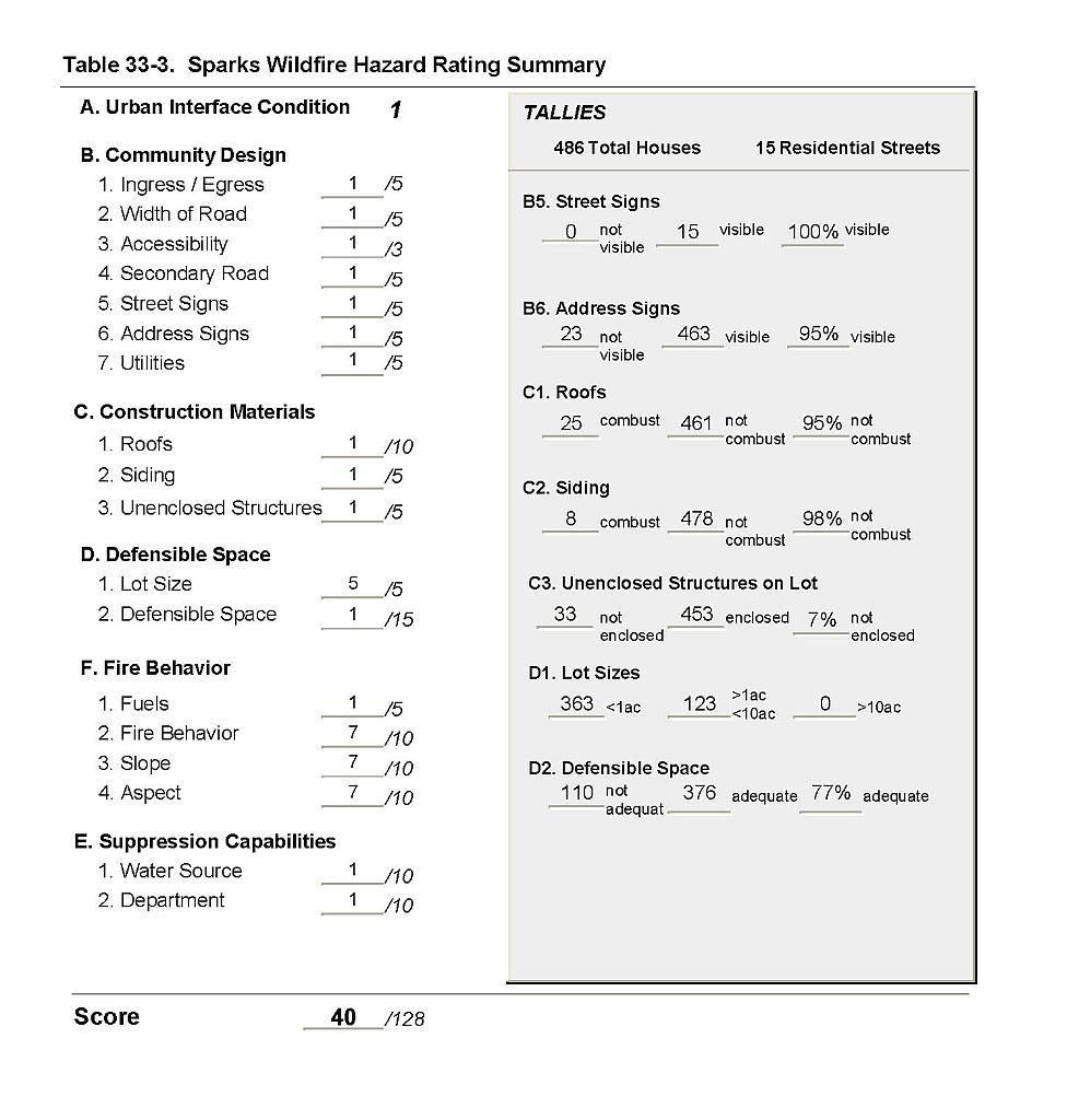 |
Figure 33-1Sparks Fire History, Suppression Resources, and Critical Features |
 |