![]()
![]()
12.0 Lund
12.1 Risk and Hazard Assessment
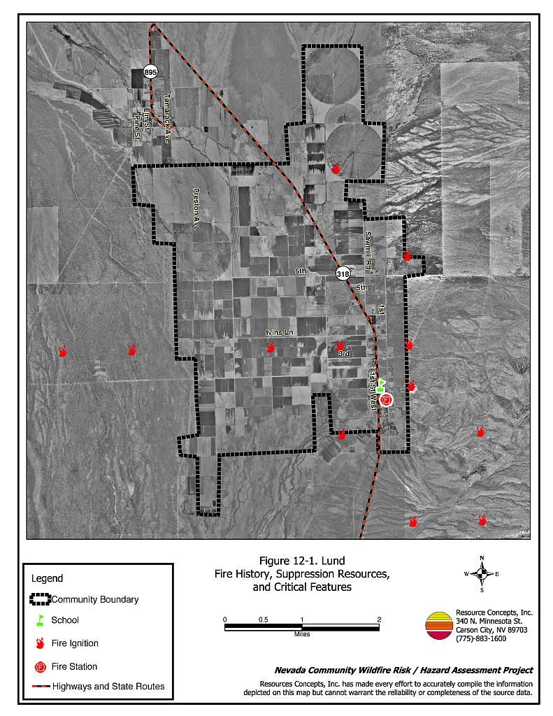
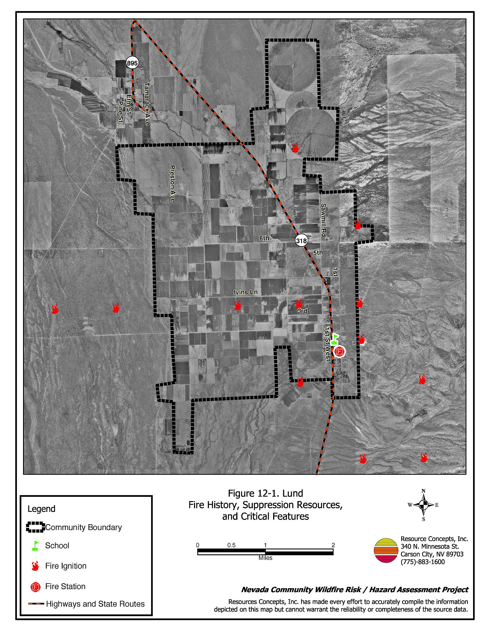
The community of Lund is located in the White River Valley along State Route 318 in southern White Pine County (see Figure 12-1). The hazard assessment resulted in classifying Lund in the Moderate Hazard Category (44 points). A summary of factors that contributed to the hazard rating is included in Table 12-3. Primary factors that determined the hazard rating for Lund were inadequate defensible space, inadequate signage, and limited fire suppression resources.
12.1.1 Community Design
The wildland-urban interface area around Lund can best be characterized as a classic interface condition. While structures abut wildland fuels, there is a clear line of demarcation between wildland fuels and residential structures. Of the 74 homes observed during the assessment, 44 were on lots of less than one acre in size and 30 were on lots of between one and ten acres.
- Access: State Route 318 is the major transportation route through Lund. The road is paved with a width of at least 24 feet. Most of the observed secondary roads were of adequate width and gradient to allow two-way vehicle passage and fire suppression maneuverability.
- Signage: Only 30 percent of the streets have signs that are easily visible from the road, and only 34 percent of homes have clearly posted address signs.
- Utilities: Utilities are all above ground, including propane tanks. Power lines have not been properly maintained to minimize the possibility that arcing may start fires in nearby vegetation.
12.1.2 Construction Materials
Eighty-four percent of the homes in the interface were built with non-combustible or ignition resistant siding material such as medium density fiberboard. Ninety-seven percent of the homes had fire resistant roofing materials such as composition, tile, or metal. Twenty percent of the homes observed had unenclosed balconies, porches, decks, or other architectural features that can create drafty areas where sparks and embers can be trapped, smolder, ignite, and rapidly spreading fire to the house.
12.1.3 Defensible Space
About seventy-five percent of the homes surveyed in Lund have landscaping that meets the minimum defensible space requirement to help protect the home from damage or loss during a wildfire.
12.1.4 Suppression Capabilities
Wildfire Protection Resources
The Lund Volunteer Fire Department provides fire protection to the Lund community. The VFD reported having eighteen members at the time that interviews were conducted for this report. The BLM Ely Field Office, the NDF Ely Conservation Camp, and the Great Basin National Park can provide additional resources as described in Section 4.1.1. Table 12-1 lists the types of wildfire resources and equipment available for initial response to a wildland fire near Lund.
| Type of Equipment | Amount of Equipment | Resource Location |
|---|---|---|
| Engine Type 3 Engine Type 6 Water Tender Type 3 Water Tender Type 1 |
1 2 1 1 |
Lund Volunteer Fire Department |
| Source: Personal communication with Chief Laine Hendrix, Lund Volunteer Fire Department. | ||
Water Sources and Infrastructure
Water availability for fire suppression in Lund includes:
- Eleven dry hydrants, and
- One water storage tank of 48,000-gallon capacity.
The water system operates by gravity. Dry hydrants must be filled manually from fire engines or tenders.
Fire Protection Personnel Qualifications
Lund VFD firefighters receive training to meet the State Fire Marshal structure firefighting training standards and NDF Basic Wildland Firefighter training standards. The Lund VFD does not utilize the Red Card system for individual qualifications. Red Card certification is part of a fire qualifications management system used by many state and all federal wildland fire management agencies. This certification indicates that an individual is qualified to fight wildland fires.
Work Load
The Lund Volunteer Fire Department responded to 47 calls in 2003: forty emergency medical calls, five wildland/brush fire calls, and two structure fire calls.
Financial Support
Funding for the Lund Volunteer Fire Department comes from the Lund Community Fund and the NDF White Pine County Fire Protection District authorized under NRS 473.
Community Preparedness
White Pine County has a Local Emergency Planning Committee that covers hazardous materials response. Lund is included in that plan. A pre-attack plan is developed by the Fire Protection District and updated annually. The Lund VFD reviews development plans for the community.
12.1.5 Factors Affecting Fire Behavior
Lund is situated in a north-south oriented valley bottom with mostly flat terrain. The predominant wind direction is from the west/southwest in the late afternoon. The fuel hazard in the Lund interface area was considered low to moderate, with fuel loads estimated at one to two tons per acre. The west side of the community is generally agricultural lands. Wildland vegetation consists primarily of a greasewood, sagebrush, and rabbitbrush, with perennial grasses, cheatgrass, and halogeton. Russian thistle occurs in disturbed areas. Numerous vacant lots within the community have accumulations of shrubs and weeds that add to the fire hazard. If an ignition occurs in one of these lots, the fire could extend into the community due to the accumulation of vegetation.
12.1.6 Fire Behavior Worst Case Scenario
The worst-case scenario for Lund would begin as a dry lightning strike during the summer of a high precipitation year with abundant cheatgrass growth. An ignition anywhere around the community could be driven by erratic winds in any direction, burning through fine fuels and shrubs. A fire could exceed first alarm resources, especially if there were multiple ignitions during normal working hours when volunteer response could be limited. Mutual aid resources more than an hour away.
12.1.7 Ignition Risk Assessment
Lund has a low ignition risk rating based on past fire and ignition history and fuel conditions. The primary ignition risk is lightning, although human caused ignitions can occur at any time.
12.2 Risk and Hazard Reduction Recommendations
The responsibility to keep a community fire safe falls not only on the local fire department but also on residents, businesses, and local governments. Lund risk and hazard reduction recommendations focus on improving defensible space and fuel reduction treatments throughout the community. Other recommendations pertain to community coordination efforts that could be initiated to enhance the fire safe nature of Lund.
12.2.1 Defensible Space Treatments
Defensible space treatments are an essential first line of defense for residential structures. Significantly reducing or removing vegetation within a prescribed distance from structures (30 feet to 200 feet depending upon slope and vegetative fuel type) reduces fire intensity and improves firefighter and homeowner chances for successfully defending a structure against an oncoming wildfire.
Property Owners Recommendations
- Remove, reduce, and replace vegetation around homes according to guidelines provided in Appendix E. This area should be kept:
- Lean: There are only small amounts of flammable vegetation.
- Clean: There is no accumulation of dead vegetation or other flammable debris.
- Green: Existing plants are healthy and green during the fire season.
- Maintain defensible space annually.
- Immediately remove cleared vegetation to an approved disposal site. This material dries quickly and poses a fire risk if left on site. Refer to the Defensible Space fact sheet in Appendix E for clearance guidelines.
- Keep the area beneath unenclosed porches and decks free of accumulated vegetation or other flammable debris. Enclose these areas wherever possible.
- Store woodpiles at least thirty feet from any structure.
- Clear all vegetation and combustible materials around propane tanks for a minimum distance of ten feet.
- Cheatgrass or other annual grasses that have become dominant within the defensible space zone should be mowed or treated with an application of pre-emergent herbicide prior to seed set. Treatments may need to be repeated the following year to ensure that the seed bank of unwanted grasses has been depleted. Refer to Appendix E for approved seed mixes and planting guidelines that can be used in conjunction with removal of this annual grass.
- Remove brush within thirty feet and grass within ten feet of fences in the community.
- Install spark arrestors on chimneys.
12.2.2 Fuels Reduction Treatments
Fuel reduction treatments are applied on a larger scale than defensible space treatments, typically along roads, railroads, vacant lots, power line corridors, or the outer boundaries of a community. Permanently lowering the amount of available fuel over a large block of land reduces the risk of a catastrophic wildfire in the treated area. Fuelbreaks can stop or slow the advance of a wildfire. They also give firefighters a place to stand against an oncoming fire.
White Pine County
- Reduce vegetation by mowing it to a height of not more than four inches for a distance of 25 feet from the edge of the pavement, along both sides of county roads. Seed or treat the cleared areas as necessary to control cheatgrass.
Electric Utility Company
Power line corridors and transformer sites should be kept clear of flammable vegetation, as fires have been known to start from arcing power lines during windy conditions. Fire damage to power lines often creates power failures that can be especially dangerous in communities without a backup energy source. Energized power lines can also fall during a wildfire creating additional hazards for citizens and firefighters.
- Maintain utility right-of-ways by removing trees from beneath power lines and thinning shrubs a minimum of fifteen feet around power line transformers.
Property Owners
- Clean up areas in the community where shrubs are overgrown and where dry tumbleweeds have accumulated including in vacant lots, along ditches, and along town roads.
12.2.3 Community Coordination
Many of the most effective activities aimed at reducing the threat of wildfire for the Lund community requires that individual property owners coordinate with each other and with local fire authorities. Defensible space, for example, is more effective in small communities when applied uniformly throughout entire neighborhoods. Public education and awareness, neighbors helping neighbors, and proactive individuals setting examples for others to follow are just a few of the approaches that will be necessary to meet the fire safe goals in the community.
Property Owners
- Assure that address signs are visible from the road. Address characters should be at least four inches high, reflective, and composed of non-flammable material. Improving visibility of addresses will make it easier for those unfamiliar with the area to navigate under smoky conditions during a wildland fire.
Lund Volunteer Fire Department
- Distribute copies of the publication “Living With Fire” to all property owners who live in Lund. This publication is free of charge and copies can be requested from the University of Nevada Cooperative Extension.
| Involved Party | Recommended Treatment | Recommendation Description |
|---|---|---|
| Property Owners | Defensible Space Treatments | Remove, reduce, and replace vegetation around homes according to the guidelines in Appendix E. Maintain defensible space as needed to keep the space lean, clean, and green. |
| Community Coordination | Post addresses so they are clearly visible. Clean up overgrown shrubs and tumbleweeds that have accumulated vegetation in vacant lots, along ditches, and along town roads. |
|
| Utility Company | Fuel Reduction Treatment | Reduce and remove vegetation around power lines and utility poles. Maintain a minimum of fifteen feet of clearance around power line transformers. |
| Lund Volunteer Fire Department | Community Coordination | Distribute copies of the publication “Living With Fire” to all property owners. |
| White Pine County | Fuel Reduction Treatment | Mow vegetation for a distance of 25-feet on each side of community roads. |
Table 12-3Lund Wildfire Hazard Rating Summary |
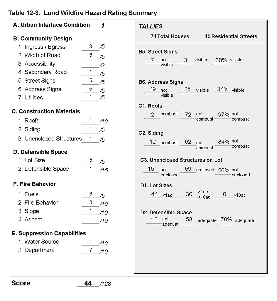 |
Figure 12-1Lund Fire History, Suppression Resources, and Critical Features |
 |