![]()
![]()
11.0 Lackawanna
11.1 Risk and Hazard Assessment
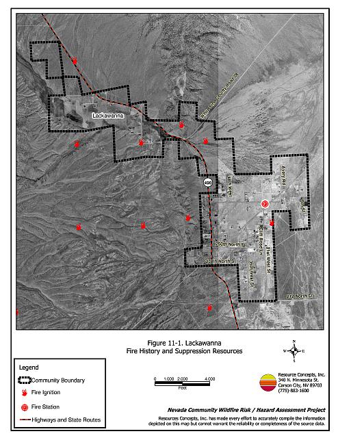
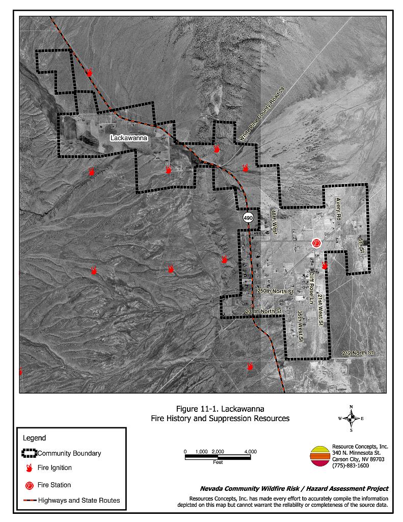
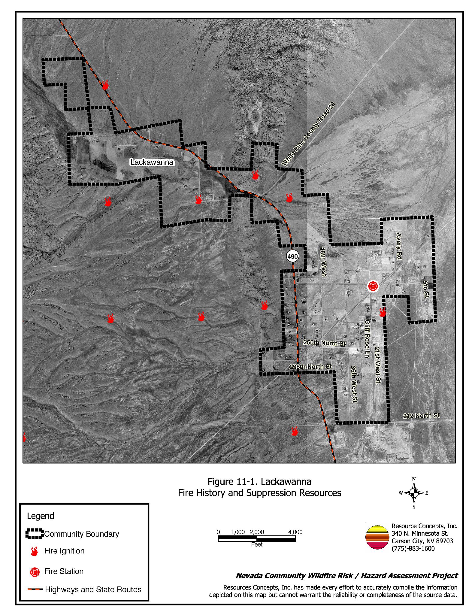
Lackawanna is located approximately one mile north of Ely (see Figure 11-1). The hazard assessment resulted in classifying Lackawanna in the Moderate Hazard Category (50 points). A summary of factors that contributed to the hazard rating is included in Table 11-3. The primary factors that determined the hazard rating for Lackawanna were inadequate signage, numerous homes with unenclosed architectural features, inadequate defensible space, and limited fire suppression resources and water.
11.1.1 Community Design
The wildland-urban interface area around Lackawanna can best be characterized as a intermix interface condition. The intermix condition is described as structures scattered throughout the wildland area with no clear line of demarcation between wildland fuels and residential structures in the community. A total off 144 homes were assessed. Nearly all of these (139) are on lots of between one and ten acres in size.
- Access: Lackawanna is accessed via State Route 490. State Route 490 is paved and at least 24 feet in width, wide enough for two-way vehicle passage and fire suppression equipment maneuverability. Secondary streets in Lackawanna are of adequate width and gradient for fire suppression equipment to maneuver.
- Signage: Just over half of the streets have easily visible signs posted in the community. Only 31 percent of the surveyed homes have easily visible address signage.
- Utilities: Utilities are all above ground. Power lines have not been properly maintained to minimize the possibility that arcing may start fires in nearby vegetation.
11.1.2 Construction Materials
Eighty-nine percent of the homes observed in the interface were built with non-combustible siding materials such as medium density fiberboard. Ninety-nine percent of the homes had fire resistant roofing materials such as composition roof or metal. Forty-three percent of the homes observed have unenclosed balconies, porches, decks, or other architectural features that can create drafty areas where sparks and embers can be trapped, smolder, ignite, and rapidly spreading fire to the home.
11.1.3 Defensible Space
Eighty percent of the homes surveyed in Lackawanna have landscaping that meets the minimum recommended distance depending upon slope and vegetative fuel type to help protect the home from damage or loss during a wildfire.
11.1.4 Suppression Capabilities
Wildfire Protection Resources
Fire protection in Lackawanna is provided by the Lackawanna Volunteer Fire Department who reported having twenty members at the time that interviews were conducted for this report. Additional resources are available through other local volunteer fire departments, the BLM Ely Field Office, the NDF Ely Conservation Camp, and the Great Basin National Park. Equipment needs at the Lackawanna VFD include acquisition of a Type 3 brush engine. Table 11-1 lists the types of wildfire resources, cooperating partners, and equipment available to Lackawanna in the event of a reported wildfire.
| Type of Equipment | Amount of Equipment | Cooperating Partner |
|---|---|---|
| Engine Type 6 Water Tender 2000-gallon |
1 1 |
Lackawanna Volunteer Fire Department |
| Engine Type 1 Engine Type 3 Engine Type 4 Water Tender |
1 1 1 4 |
City of Ely Fire Department |
| Engine Type 1 Engine Type 2 Rescue Unit |
1 1 2 |
McGill Volunteer Fire Department |
| Engine Type 1 Engine Type 4 Water Tender Rescue Unit |
1 1 1 2 |
Ruth Volunteer Fire Department |
| Source: Chief Bill Ward, Lackawanna Volunteer Fire Department; White Pine County Community Wildfire Hazard/Risk Assessment June 2003 (RCI). | ||
Water Sources and Infrastructure
The community of Lackawanna does not have a community water system or storage tanks with hydrants. Water for residents is supplied by individual wells. Lackawanna received a community block grant to test their existing well for fire suppression. It was determined that the well does not provide an adequate water supply. The town is currently developing a new well that will provide 300-350 gpm. The well site will include a pump, a hydrant, and an overhead fill station for fire engines and water tenders.
Fire Protection Personnel Qualifications
Lackawanna volunteer firefighters receive training to meet the State Fire Marshal structure firefighting and NDF Basic Wildland Firefighter standards. The Lackawanna VFD has used utilized the Red Card system in the past, but it has not utilized it for the last two years. Red Card certification is part of a fire qualifications management system used by many state and all federal wildland fire management agencies. This certification indicates that an individual is qualified to fight wildland fires.
Work Load
The Lackawanna VFD responded to twelve calls in 2003: five wildland/brush fire calls, six emergency medical calls, and one other call.
Financial Support
Funding for the Lackawanna VFD is derived from organization of the Lackawanna Fire Protection District, authorized under NRS 473, Fire Protection Districts Receiving Federal Aid. The Lackawanna VFD also receives funding from the White Pine County general fund and from fundraisers.
Community Preparedness
White Pine County has a Local Emergency Planning Committee that oversees the county emergency hazardous materials plan and the disaster plan. Lackawanna is included in that plan. The Lackawanna VFD has a pre-attack plan for fire response that is updated annually as part of their annual fire training. The VFD does not review development plans.
11.1.5 Factors Affecting Fire Behavior
The community extends across the northwest portion of Steptoe Valley and west into Smith Valley. The terrain is generally flat but consists of some moderate slopes at Hercules Gap. Winds are predominantly from the west to southwest in the late afternoons. Vegetative fuel loading in the Lackawanna interface area varied from one to three tons per acre around most of the community. West of Hercules Gap fuel loads were estimated at four to six tons per acre. Vegetation on the west side of the community consists primarily of a shrub overstory of big sagebrush, rabbitbrush, and greasewood. The understory consists primarily of annual grasses, such as cheatgrass, and some perennial grasses. Several abandoned agricultural fields near the fire station have reverted to shrubs, halogeton, cheatgrass, and some bottlebrush squirreltail. Annual kochia has become established along the edges of roadways and around buildings. Vegetation on the east side of the community consists primarily of sagebrush with some winterfat, halogeton, and cheatgrass. The fuel hazard was considered moderate surrounding most of the Lackawanna community boundary, but it was considered high in Hercules Gap where slopes and vegetation density increase.
11.1.6 Fire Behavior Worst Case Scenario
The worst-case scenario for Lackawanna would likely occur during a dry lightning storm with multiple lightning-strike fire ignitions near the community. If the fire occurred in the afternoon of a high fire hazard day during June, July, or August, high-speed, erratic winds could push the fire into the community from any direction. In years with higher than normal precipitation, annual grass growth will increase, thereby increasing the fine fuel loads in the vicinity of and within the community. Higher fuel loads and steeper slopes near Hercules Gap, adds to the fire behavior risk because fire moves faster upslope with longer flame lengths.
11.1.7 Ignition Risk Assessment
Lackawanna has a moderate ignition risk based on its previous ignition history. There have been no large wildfires in recent records, but there is no ignition history from dry lightning strikes and some history of small fires. The primary ignition risk in Lackawanna is lightning, although human caused ignitions can occur at any time.
11.2 Risk and Hazard Reduction Recommendations
The responsibility to keep a community fire safe falls not only on the local fire department but also on residents, businesses, and local governments. Lackawanna risk and hazard reduction recommendations focus primarily on implementing and maintaining defensible space, fuel reduction treatments along roads, power line corridors, and the electrical transfer stations, and improvement of fire suppression equipment and resources.
11.2.1 Defensible Space Treatments
Defensible space treatments are an essential first line of defense for residential structures. Significantly reducing or removing vegetation within a prescribed distance from structures (30 feet to 200 feet depending upon slope and vegetative fuel type) reduces fire intensity and improves firefighter and homeowner chances for successfully defending a structure against an oncoming wildfire.
Property Owners Recommendations
- Remove, reduce, and replace vegetation around homes according to guidelines provided in Appendix E. This area should be kept:
- Lean: There are only small amounts of flammable vegetation.
- Clean: There is no accumulation of dead vegetation or other flammable debris.
- Green: Existing plants are healthy and green during the fire season.
- Immediately remove cleared vegetation to an approved disposal site. This material dries quickly and poses a fire risk if left on site. Refer to the Defensible Space fact sheet in Appendix E for clearance guidelines.
- Keep the area beneath unenclosed porches and decks free of accumulated vegetation or other flammable debris. Enclose these areas wherever possible.
- Store woodpiles at least thirty feet from any structure.
- Clear all vegetation and combustible materials around propane tanks for a minimum distance of ten feet.
- Cheatgrass or other annual grasses that have become dominant within the defensible space zone should be mowed or treated with an application of pre-emergent herbicide prior to seed set. Treatments may need to be repeated the following year to ensure that the seed bank of unwanted grasses has been depleted. Refer to Appendix E for approved seed mixes and planting guidelines that can be used in conjunction with removal of this annual grass.
- Remove brush growing within thirty feet and mow grass within ten feet of fences in the community.
- Install spark arrestors on chimneys.
- Maintain this defensible space as needed to keep the space lean, clean, and green.
- Improve street and residential signage.
- Remove, or board up windows and doors in empty trailers or other structures to prevent sparks from a wildfire entering and igniting the structure.
11.2.2 Fuel Reduction Treatments
Fuel reduction treatments are applied on a larger scale than defensible space treatments. By permanently changing the fuel structure over large blocks of land to one of lower volume or reduced flammability (a fuel reduction treatment), the expected result in the event of a catastrophic wildfire would be one of reduced risk for uncontrolled spread through the treatment area. Reducing vegetation along roadways and driveways could reduce the likelihood of wildfire spreading across roads and improve firefighter access and safety for protecting homes.
White Pine County
- Reduce vegetation by mowing it to a height of not more than four inches for a distance of 25 feet from the edge of the pavement, along both sides of county roads. Seed or treat the cleared areas as necessary to control cheatgrass.
Nevada Department of Transportation
- Reduce vegetation by mowing to a height of not more than four inches for a distance of 25 feet from the edge of the pavement along both sides of State Route 490. Treat the cleared areas as necessary to control cheatgrass.
Electric Utility Company
- Maintain utility right-of-ways by removing trees from beneath power lines and thinning shrubs a minimum of fifteen feet around power line transformers.
11.2.3 Fire Suppression Resources
Adequate training, equipment, and water drafting supplies are critical to all firefighters, whether they are first responders, volunteer fire department personnel, or agency personnel. These matters are also of special importance to all communities, especially those located in remote portions of the county. The following recommendations are related to actions the county and fire departments can take to increase the quality of fire suppression response in their community.
Lackawanna Volunteer Fire Department, Nevada Division of Forestry
- Complete the fire fill station project.
- Continue to provide all volunteer firefighters with annual wildland fire training including the use of fire shelters and State Fire Marshal structure firefighting training.
- Meet annually with the Nevada Division of Forestry, the Bureau of Land Management, and the Great Basin National Park fire management personnel to review pre-attack plans and to coordinate firefighting resources and response procedures.
White Pine County
- Coordinate with Nevada Division of Forestry to secure funding to upgrade existing fire suppression equipment including a new structure engine and a Type 3 wildland fire engine.
11.2.4 Community Coordination
Many of the most effective activities aimed at reducing the threat of wildfire in Lackawanna requires that individual property owners coordinate with each other and with local fire authorities. Defensible space, for example, is more effective in small communities when applied uniformly throughout entire neighborhoods. Public education and awareness, neighbors helping neighbors, and proactive individuals setting examples for others to follow are just a few of the approaches that will be necessary to meet the fire safe goals in the community.
Property Owners
- Assure that address signs are visible from the road. Address characters should be at least four inches high, reflective, and composed of non-flammable material. Improving visibility of addresses will make it easier for those unfamiliar with the area to navigate under smoky conditions during a wildland fire.
Lackawanna Volunteer Fire Department
- Distribute copies of the publication “Living With Fire” to all property owners who live in Lackawanna. This publication is free of charge and copies can be requested from the University of Nevada Cooperative Extension.
| Involved Party | Recommended Treatment | Recommendation Description |
|---|---|---|
| Property Owners | Defensible Space Treatments | Remove, reduce, and replace vegetation around homes according to the guidelines in Appendix E. Maintain defensible space as needed to keep the space lean, clean, and green. Mow or treat cheatgrass to deplete the seed bank. Reseed with species according to the seed mix in Appendix E. |
| Community Coordination | Post addresses so they are clearly visible. | |
| Utility Company | Fuel Reduction Treatments | Reduce and remove vegetation around power lines and utility poles. Maintain a minimum of fifteen feet of clearance around power line transformers. |
| Nevada Department of Transportation White Pine County |
Fuel Reduction Treatments | Reduce vegetation by mowing to a height of not more than four inches for a distance of 25 feet from the edge of pavement along both sides of county roads and State Route 490. |
| Fire Suppression Resources | Upgrade fire suppression equipment. | |
| Lackawanna Volunteer Fire Department | Fire Suppression Resources | Continue to obtain wildland fire training. Meet annually with BLM, NDF, and GBNP fire management personnel to review pre-attack plans. Complete construction of the fire fill station. |
| Community Coordination | Distribute copies of the publication “Living With Fire” to all property owners. |
Table 11-3Lackawanna Wildfire Hazard Rating Summary |
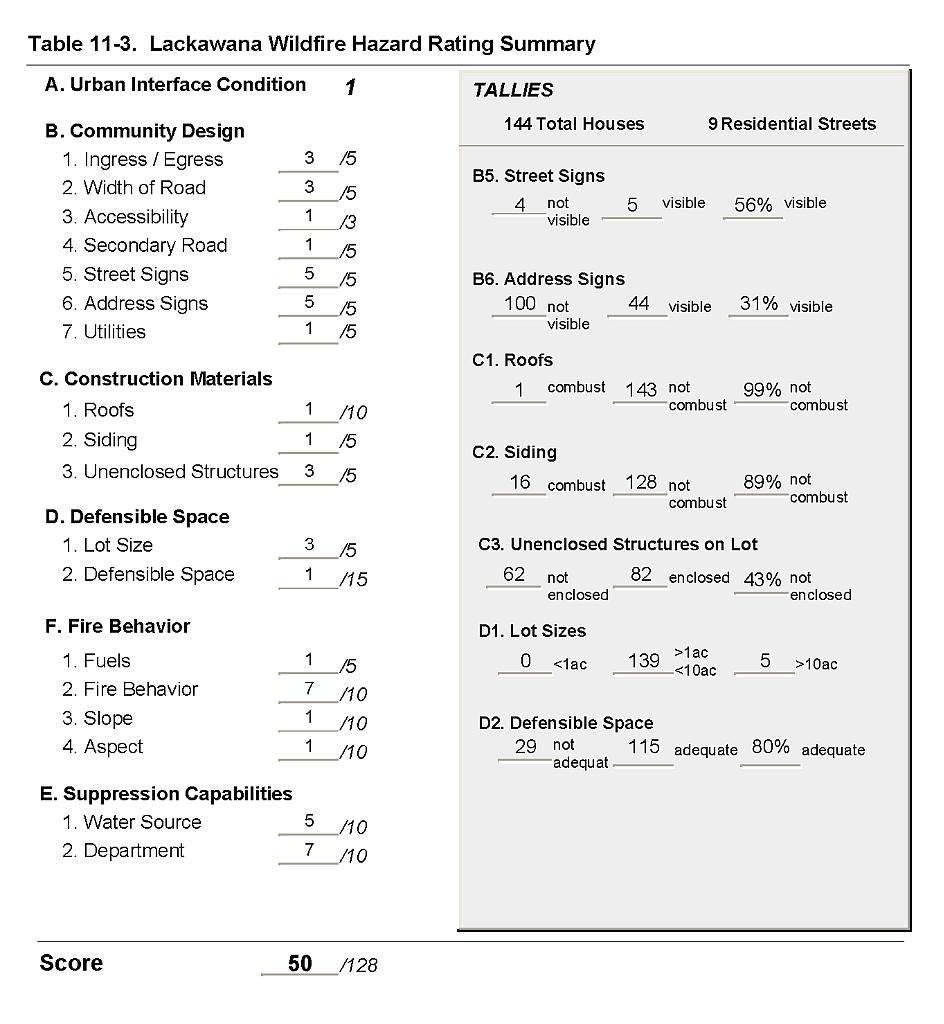 |
Figure 11-1Lackawanna Fire History and Suppression Resources |
 |