![]()
![]()
16.0 Mountain City
16.1 Risk and Hazard Assessment
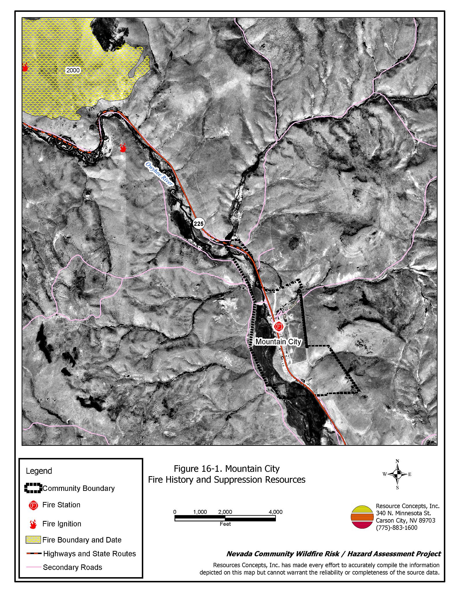
Mountain City is located on State Route 225, approximately sixteen miles south of the Idaho border. Mountain City is situated on the Owyhee River at an elevation of approximately 5,620 feet. The community hazard assessment resulted in classifying Mountain City in the High Hazard category (61 points). A summary of the factors that contributed to the hazard rating is included in Table 16-3. The primary factors that contributed to the rating were inadequate signage, inadequate defensible space, and potentially hazardous fire behavior. The community boundary identified for this report is shown in Figure 16-1.
16.1.1 Community Design
Mountain City has a classic wildland-urban interface condition. There is a clear line of demarcation between structures and wildland fuels. Of the 31 homes included in the assessment, 25 are on lots of less than one acre and six are on lots of one to ten acres.
- Access: State Route 225 is the major transportation route through Mountain City. The highway is at least 24 feet wide and has adequate turnaround space for fire suppression equipment to maneuver. Secondary roads are of adequate width and grade for two-way passage.
- Signage: Street signs are posted on four of the five streets in the community. Residential addresses are clearly visible on only 61 percent of the homes observed. Clear and visible street signs and residential addresses are important in locating homes during low visibility conditions that occur during a wildfire.
- Utilities: All of the utilities are above ground. Power line corridors have been properly maintained to minimize wildfire damage to electric utilities and reduce the possibility that sparks could start a fire in adjacent vegetation.
16.1.2 Construction Materials
Eighty-four percent of the homes observed in the interface area are built with non-combustible or highly fire resistant siding materials such as medium density fiberboard. Ninety-four percent of the homes have fire resistant roofing materials such as composition roofing, metal, or tile. Twenty-six percent of the homes have unenclosed porches, decks, or balconies that create drafts and provide areas where sparks and embers can lodge, smolder, ignite, and rapidly spread fire to the house.
16.1.3 Defensible Space
Sixty-eight percent of the homes observed in the interface meet the minimum recommended defensible space requirement to help protect the home from damage or loss during a wildfire.
16.1.4 Suppression Capabilities
Wildfire Protection Resources
The Mountain City Volunteer Fire Department, staffed by four volunteers, provides fire protection in Mountain City. Table 16-1 lists the types of local wildfire resources, cooperating partners, and equipment available for initial response to Mountain City in the event of a reported wildfire. Additional resources are available from local, state, and federal agencies through mutual aid agreements as described in Section 4.1.1.
| Type of Equipment | Amount of Equipment | Cooperating Partner (Resource Location) |
|---|---|---|
| Type 2 Engine | 1 | Mountain City VFD (Mountain City) |
| Type 6 Engine |
1 | US Forest Service
(Mountain City) |
| Type 2 Engine Type 1 Water Tender |
1 1 |
Nevada Division of Forestry (Elko) |
| Source: Sam Hicks, Nevada Division of Forestry Elko County Prevention Captain; Tom Turk, Nevada Division of Forestry Northern Region Battalion Chief; Melody Asher, US Forest Service Zone FMO. | ||
Water Sources and Infrastructure
Water available for fire suppression in Mountain City includes hydrants within 500 feet of structures; the minimum flow for these hydrants is 500 gallons per minute, operated by gravity flow into the tank from four springs at a rate of approximately 60 gpm. From one 150,000-gallon water storage tank, a single hydrant at the bottom of the hill is capable of 2,000 gpm. The Owyhee River and local ponds can be used as helicopter dip spots or draft sites.
Fire Protection Personnel Qualifications
The Mountain City volunteers have received training from the Nevada Division of Forestry and cooperating agencies to meet the minimum National Wildfire Coordinating Group basic wildland standards.
Work Load
The Mountain City VFD responded to three calls in 2003:
- Two wildland/brush fire calls.
- One other type of call.
16.1.5 Factors Affecting Fire Behavior
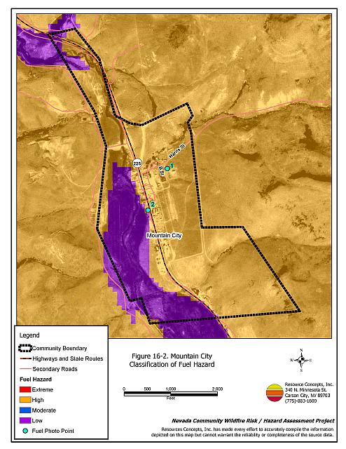
The vegetative fuel density in the Mountain City interface area is generally moderate, estimated at two to four tons per acre. The fuel hazard is low along the river corridor, but increases to a high hazard elsewhere within the community due to slope and aspect. Fuels in the community consist primarily of shrubs one to four feet high that include sagebrush and rabbitbrush, with ground fuels of basin wildrye, lupine, cheatgrass, and perennial grasses. Cheatgrass growth is dependent on annual moisture and will produce increased fuel volumes and elevate fuel hazard conditions in years of higher than average precipitation. Riparian areas along the Owyhee River are predominantly meadow grasses, willows, and sagebrush. Fuel hazard mapping is shown in Figure 16-2. Fuel hazard photo points are shown in Figure 16-3. The terrain within the community boundary is gently sloping from eight to twenty percent, with a west aspect. The prevailing wind direction is south/southwest. There is a history of afternoon thunderstorms and dry lightning strikes in the area.
16.1.6 Fire Behavior Worst Case Scenario
The worst-case scenario for a wildfire in the area surrounding Mountain City would come from a dry lightning storm late on a summer afternoon during a year of normal to above normal precipitation and high annual grass and forb production. Multiple fire ignitions in the area would spread firefighting resources thin. High erratic winds would push fires into the community.
16.1.7 Ignition Risk Assessment
Mountain City has a high ignition risk based on fire history in the area and the potential for increased fuel loading from annual grasses in high precipitation years. There is an extensive wildfire history in the public lands surrounding the community and a history of lightning strikes around the community. The primary risk of ignition in Mountain City is lightning, although human caused ignitions are unpredictable and can occur at any time.
16.2 Risk and Hazard Reduction Recommendations
The responsibility to keep a community fire safe falls not only on the local fire protection district but also on the residents, businesses, and local governments. The recommendations for the Mountain City area focus primarily on the ongoing and additional efforts to create and maintain defensible space and the community coordination and public education efforts that could be undertaken to enhance fire safety.
16.2.1 Defensible Space Treatments
Defensible space treatments are an essential first line of defense for residential structures. The goal of the treatments is to significantly reduce or remove flammable vegetation within a prescribed distance from structures. (Refer to Appendix E for the minimum recommended defensible space area). Defensible space reduces the fire intensity and improves firefighter and homeowner chances for successfully defending a structure against oncoming wildfire.
Property Owners Responsibilities
- Remove, reduce, and replace vegetation around homes according to the guidelines in Appendix E. This area should be kept:
- Lean: There are only small amounts of flammable vegetation.
- Clean: There is no accumulation of dead vegetation or other flammable debris.
- Green: Existing plants are healthy and green during the fire season.
- Store woodpiles a minimum distance of thirty feet from any structure.
- Remove all dead vegetation and other flammable materials a minimum of five feet from the exterior of the structure.
- Mow or remove brush growing against fences in the community. The minimum distance for clearance should be ten feet in grass and 25 feet in brush.
- Maintain areas under wood decks and porches free of weeds and other flammable debris. Enclose these areas when possible. Box in eves and cover attic and other ventilation openings with very fine metal wire mesh to prevent embers from entering the attic or crawl space.
- Replace wood shake roofs with fire resistant materials such as metal, tile, or composition.
- Clear all vegetation and combustible materials around propane tanks for a minimum distance of ten feet.
- Where cheatgrass has become dominant within the defensible space zone, areas should be mowed prior to seed maturity or treated with an application of a pre-emergent herbicide. Treatments may need to be repeated for several years to ensure that the seed bank of unwanted annual grass seeds has been depleted. Refer to Appendix E for a recommended seed mixture and planting guidelines that can be used in conjunction with cheatgrass removal.
- Install spark arrestors on chimneys.
- Prune limbs from fir trees to a height of fifteen feet, but not more than one-third the height of the total tree height. Prune limbs from juniper trees to a minimum height of four feet from the ground, but not more than one-third the total tree height. Pruning should be completed to reduce ladder fuels on all deciduous and coniferous trees within the defensible space zone. Prune all dead and diseased branches.
- Prune all tree branches to a minimum distance of fifteen feet from buildings, paying special attention to areas around chimneys.
- Immediately dispose of cleared vegetation when implementing defensible space treatments. This material dries quickly and poses a fire hazard if left on site.
- Maintain the defensible space as needed.
16.2.2 Fire Suppression Resources
Mountain City VFD and Nevada Division of Forestry
- Continue to meet annually with cooperating agencies to review pre-attack plans and test radio compatibility.
- Upgrade the VFD radio system to narrow band technology to ensure proper communication compatibility.
- Upgrade fire suppression apparatus.
16.2.3 Community Coordination
Property Owners
- Form a local community-based organization to take responsibility and provide leadership for community-wide fuels reduction and community fire safety. The Nevada Fire Safe Council is one option for community organization. Through the establishment of a local Nevada Fire Safe Council Chapter, local communities will become part of a large network for sharing information, including notification of programs and funding opportunities for fire mitigation projects such as those listed in this report. The Nevada Fire Safe Council will accept and manage grants and contracts on the Chapter’s behalf through its non-profit status. The Nevada Fire Safe Council will provide assistance and support to communities to complete fire safe plans, set priorities, educate and train community members, and promote success stories of its members. To form a local chapter or for more information contact the:
Nevada Fire Safe Council
210 South Roop Street Suite 101
Carson City, NV 89701
www.nvfsc.org - Ensure residential addresses are easily visible from the road. Address characters should be at least four inches high, reflective on a dark background, and made of non-flammable material. Improving visibility of addresses will make it easier for those unfamiliar with the area to navigate under smoky conditions during a wildfire.
16.2.4 Public Education
A public education program that explains fire safe measures in clear and emphatic terms will have an impact on residents of the wildland-urban interface. Informed community members will be more inclined to make efforts to effectively reduce wildfire hazards around their homes and neighborhoods.
Mountain City VFD and Nevada Division of Forestry
- Distribute copies of the publication “Living With Fire” to all property owners. This publication is free of charge. Copies can be requested from the University of Nevada Cooperative Extension.
16.3 Summary of Recommendations
| Involved Party | Recommended Treatment | Recommendation Description |
|---|---|---|
| Property Owners |
Defensible Space | Remove, reduce, and replace vegetation around homes, equipment, and hay storage areas according to the guidelines in Appendix E. Maintain the defensible space annually. |
| Community Coordination | Ensure residential addresses are easily visible from the road. Form a local community-based organization to provide leadership and be responsible for community-wide fuels reduction and community fire safety. |
|
| Mountain City VFD and Nevada Division of Forestry |
Fire Suppression Resources | Continue to meet annually with the cooperating agencies to review pre-attack plans and test radio compatibility. Upgrade the VFD radio system to narrow band technology to ensure proper communication compatibility. Upgrade fire suppression apparatus. |
| Public Education | Distribute copies of the publication “Living With Fire” to all property owners. |
Table 16-3Mountain City Wildfire Hazard Rating Summary |
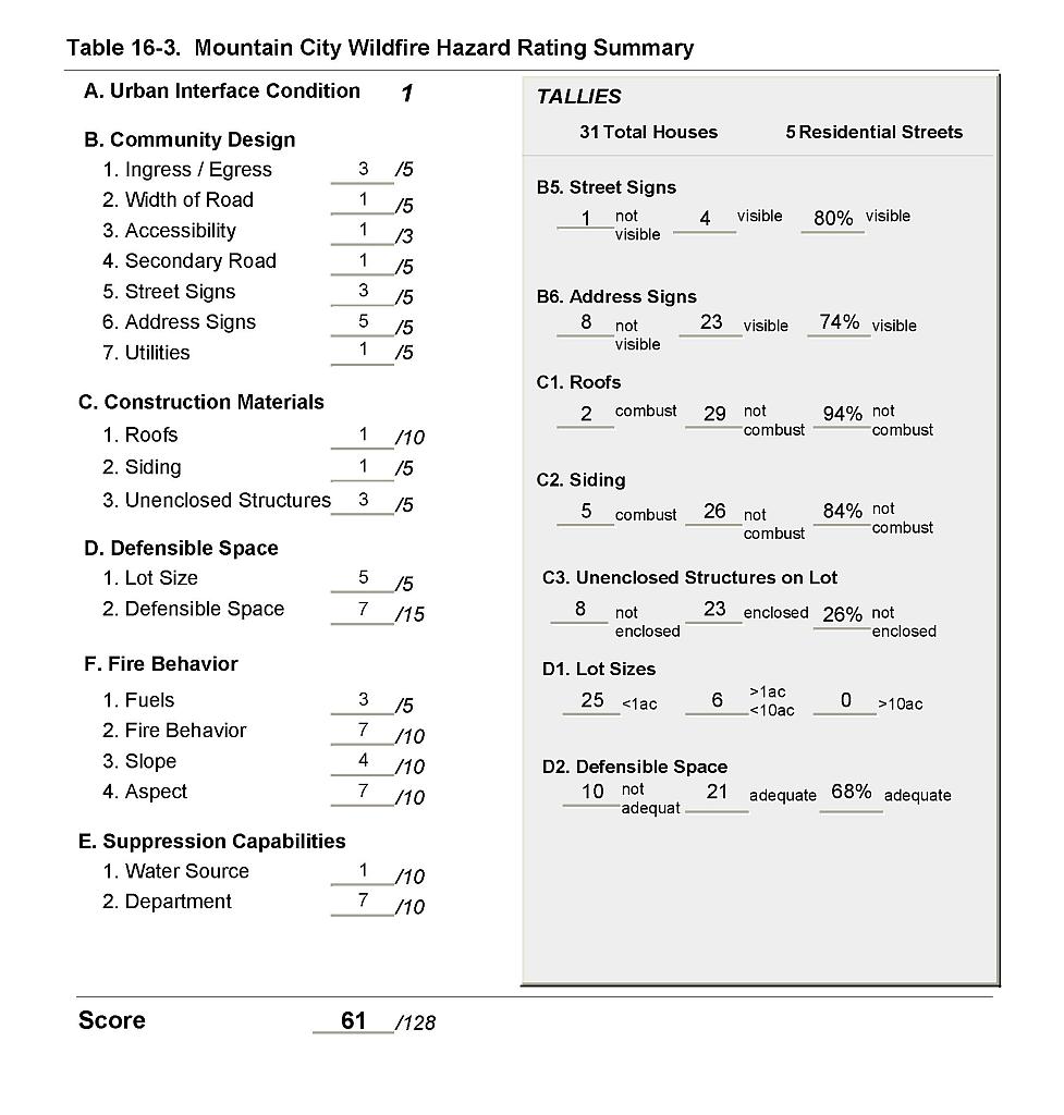 |
Figure 16-1Mountain City Fire History and Suppression Resources |
 |
Figure 16-2Mountain City Classification of Fuel Hazard |
 |
Figure 16-3. Mountain City Fuel Hazard Photo Points
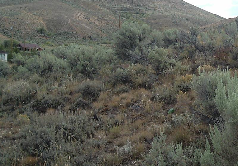
Photo Point 1. 4632453N, 586093E, 060°NE. Mountain City ground fuels include cheatgrass, basin wildrye, lupine, and perennial grasses. The shrub layer is rabbitbrush and sagebrush that is one to four feet high, with a fuel loading density of one to two tons an acre.
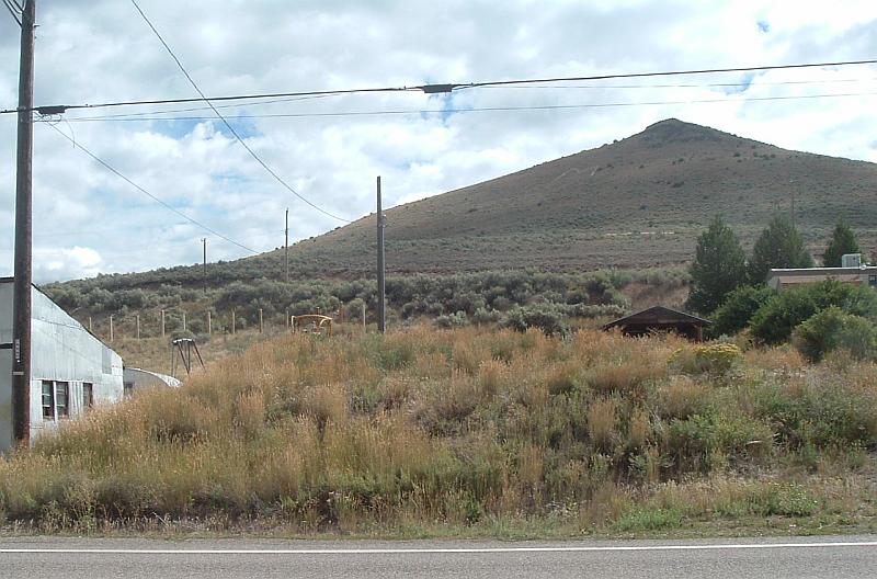
Photo Point 2. 4632183N, 585967E, 070°NE. Perennial grasses on steep slopes add to the hazard in the community if they are not mowed or grazed to reduce biomass.