![]()
![]()
17.0 Osino
17.1 Risk and Hazard Assessment
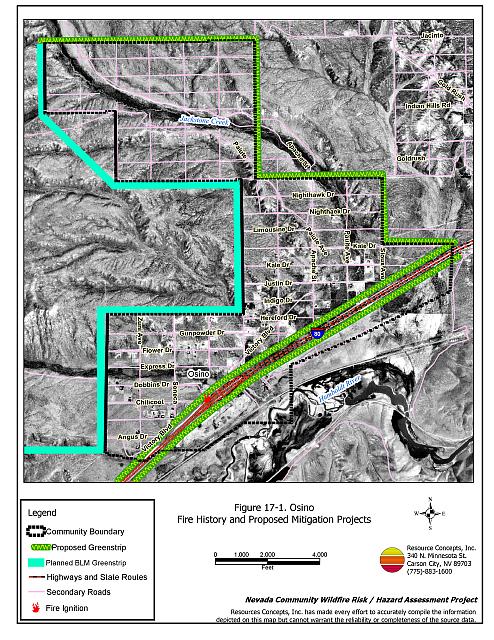
Osino is a small community located on Interstate 80 approximately ten miles east of Elko in central Elko County. Jackstone Creek flows through the community and the Humboldt River flows along the south side of I-80. Osino is situated near the base of Elko Mountain at an elevation of approximately 5,130 feet. The community hazard assessment resulted in classifying Osino in the High Hazard category (70 points). A summary of the factors that contributed to the hazard rating is included in Table 17-3. The primary factors that contributed to the high rating were poor signage, a high number of homes with unenclosed architectural features, inadequate defensible space, the potential for hazardous fire behavior factors related to fuel loading and topography, and no local fire department or water sources. The community boundary identified for this report is shown in Figure 17-1.
17.1.1 Community Design
Osino has an intermix wildland-urban interface condition. Structures are scattered throughout the community with no clear line of demarcation between structures and wildland fuels. All 206 homes included in the assessment are located on parcels one to ten acres in size.
- Access: Interstate 80 is the major transportation route through Osino. The road is at least 24 feet wide, dirt, and has adequate turnaround space for fire suppression equipment. The community roads have grades less than five percent and have adequate turnaround space for fire suppression equipment. Road are not regularly maintained, and access can be difficult due to rut formation following thunder showers.
- Signage: Few street signs are posted in Osino. Only 33 percent of residential addresses are clearly visible. Clear and visible street signs and residential addresses are important in locating homes during low visibility conditions that occur during a wildfire.
- Utilities: All of the utilities are above ground. Power line corridors need proper maintenance to minimize wildfire damage to electric utilities and reduce the possibility that sparks could start a fire in adjacent vegetation.
17.1.2 Construction Materials
Ninety-nine percent of the homes observed in the interface area are built with non-combustible or highly fire resistant siding materials such as medium density fiberboard. Eighty-nine percent of the homes have fire resistant roofing materials such as composition roofing, metal, or tile. Approximately forty percent of the homes have unenclosed porches, decks, or balconies that create drafts and provide areas where sparks and embers can be trapped, smolder, ignite, and rapidly spread fire to the house.
17.1.3 Defensible Space
Eighty-five percent of homes observed in the interface meet the minimum recommended defensible space requirement to help protect the home from damage or loss during a wildfire.
17.1.4 Suppression Capabilities
Wildfire Protection Resources
There are no local fire department or fire suppression resources in Osino. The closest community with a fire department is Ryndon or Elko, about five miles away. Table 17-1 lists the types of local wildfire resources and equipment available for initial response to Osino in the event of a reported wildfire. Additional resources are available from local, state, and federal agencies through mutual aid agreements as described in Section 4.1.1.
| Type of Equipment | Amount of Equipment | Cooperating Partner (Resource Location) |
|---|---|---|
| Type 2 Engine Type 6 Engine |
1 1 |
Ryndon VFD (Ryndon) |
| Type 3 Engine Type 1 Water Tender |
1 1 |
Nevada Division of Forestry (Elko) |
| Type 4 Engine | 1 | Bureau of Land Management (Elko) |
| Type 2 Engine Type 3 Engine |
1 1 |
Lee Engine Company (Elko) |
| Source: Sam Hicks, Nevada Division of Forestry Elko County Prevention Captain; Bill Krohn, Ryndon VFD Fire Chief; Walt Howell, Deeth/Starr Valley VFD Chief. | ||
Water Sources and Infrastructure
There is no local water system or water storage for fire suppression in Osino. Some small creeks could be used for draft sites, depending on water levels. A 30,000-gallon water storage tank across Interstate 80 could be used during an emergency.
17.1.5 Factors Affecting Fire Behavior
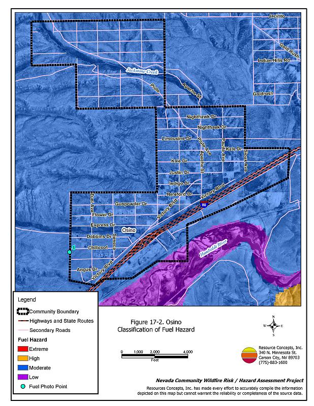
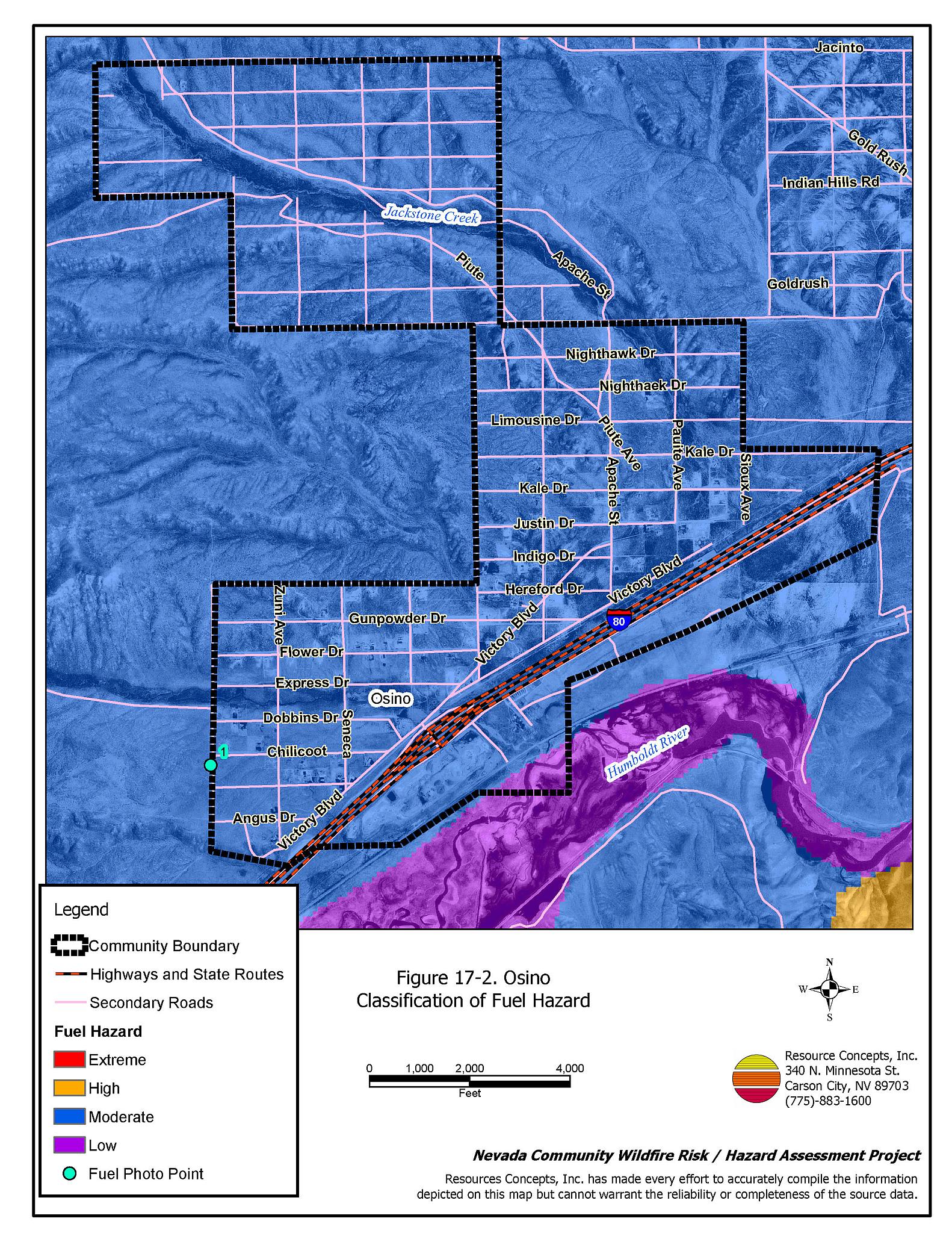
The vegetative fuel density in the Osino interface area is high, estimated at three to five tons per acre. Along the Humboldt River corridor the fuel hazard is low and in other areas of the community the fuel hazard is moderate, with the potential to increase to high in years of increased annual grass production. Fuels in the community consist primarily of shrubs three to six feet tall that include sagebrush and rabbitbrush. Ground fuels consist of halogeton, perennial grasses, and some cheatgrass. Cheatgrass growth is dependent on annual moisture and will result in higher volumes of fuel and elevated fuel hazard conditions in years of higher than average precipitation. Kochia and Russian thistle grow in vacant lots, abandoned agricultural fields, and along roadsides. Both are highly flammable when dry. The terrain within the community boundary is sloping from eight to twenty percent with a south aspect. The prevailing wind direction is from the southwest/west. There is a history of afternoon thunderstorms and dry lightning strikes in the area.
The Bureau of Land Management Elko Field Office is planning the third phase of the Elko North greenstrip along the north side of Interstate 80 from Elko to the northwest boundary of Osino. The greenstrip will be 300 feet wide for a total treatment area of approximately 285 acres and will reduce the fuel hazard for the communities of Osino and Elko.
17.1.6 Fire Behavior Worst Case Scenario
The worst-case scenario for a wildfire in the area surrounding Osino would come from a dry lightning storm on a summer day in a year with normal to above normal precipitation and high annual grass and forb production. Multiple fire ignitions south and west of the community on the north side of I-80 with predominant southwest to west winds would push fires into the community. Poor roads and some steep slopes would slow initial attack forces. There is no water system or fire hydrants to support fire suppression operations.
17.1.7 Ignition Risk Assessment
Osino has a high ignition risk based on fire history in the area and the potential for increased fuel loading from annuals in high precipitation years. There is an extensive wildfire history in the public lands surrounding the community and a history of lightning strikes around the community. The primary risk of ignition in Osino is lightning, although human caused ignitions are unpredictable and can occur at any time.
17.2 Risk and Hazard Reduction Recommendations
The responsibility to keep a community fire safe falls not only on the local fire protection district but also on the residents and local governments. The recommendations for the Osino area focus primarily on the ongoing and additional efforts to create and maintain defensible space and on the future requirements that new developments will be planned and constructed to create fire safe communities. Other recommendations pertain to community coordination and public education efforts that could be undertaken to enhance fire safety.
17.2.1 Defensible Space Treatments
Defensible space treatments are an essential first line of defense for residential structures. The goal of the treatments is to significantly reduce or remove flammable vegetation within a prescribed distance from structures. (Refer to Appendix E for the minimum recommended defensible space area). Defensible space reduces the fire intensity and improves firefighter and homeowner chances for successfully defending a structure against oncoming wildfire.
Property Owners Recommendations
- Remove, reduce, and replace vegetation around homes according to the guidelines in Appendix E. This area should be kept:
- Lean: There are only small amounts of flammable vegetation.
- Clean: There is no accumulation of dead vegetation or other flammable debris.
- Green: Existing plants are healthy and green during the fire season.
- Store firewood a minimum distance of thirty feet from structures.
- Remove all dead vegetation and other flammable materials a minimum of five feet from the exterior of the structure.
- Mow or remove brush growing against fences in the community. The minimum distance for clearance should be ten feet in grass and 25 feet in brush.
- Maintain areas under wood decks and porches free of weeds and other flammable debris. Enclose these areas when possible. Box in eves and cover attic and other ventilation openings with very fine metal wire mesh to prevent embers from entering the attic or crawl space.
- Where cheatgrass has become dominant within the defensible space zone, areas should be mowed prior to seed maturity or treated with an application of a pre-emergent herbicide. Treatments may need to be repeated for several years to ensure that the seed bank of unwanted annual grass seeds has been depleted. Refer to Appendix E for a recommended seed mixture and planting guidelines that can be used in conjunction with cheatgrass removal.
- Immediately dispose of cleared vegetation when implementing defensible space treatments. This material dries quickly and poses a fire hazard if left on site.
- Clear all vegetation and combustible materials around propane tanks for a minimum distance of ten feet.
- Where brush and Russian thistle (tumbleweed) have accumulated in vacant lots or agricultural fields, mow or use a brush hog to remove the fuel load. Mowing will need to be repeated in the following years to ensure that the seed bank has been depleted.
- Maintain the defensible space as needed.
17.2.2 Fuel Reduction Treatments
Fuel reduction treatments are applied on a larger scale than defensible space treatments. Permanently changing the fuel characteristics over large blocks of land to one of a lower volume and one of altered distribution reduces the risk of a catastrophic wildfire in the treated area. Reducing vegetation along roadways and driveways could reduce the likelihood of blocking access and escape routes, help contain the fire perimeter, and improve firefighter access and safety for protecting homes.
Elko County
- Continue to reduce vegetation and maintain roads by mowing all vegetation to a height of no more than four inches for a distance of twenty feet from the edge of the road on both sides of the road. Remove biomass and disposed of it at an appropriate site. Reseed treated areas with fire resistant species such as recommended in Appendix E to minimize cheatgrass and noxious weed invasion.
Nevada Division of Forestry and Bureau of Land Management
- Coordinate with property owners to develop a 150 foot-wide greenstrip around the entire development area and construct a greenstrip within the I-80 corridor and the old Highway 40 corridor, as shown in Figure 17-1.
Utility Company
- Reduce and remove vegetation to maintain clearance around power lines. Clear vegetation within fifteen feet of utility poles near the community.
Nevada Division of Forestry, Bureau of Land Management, Nevada Department of Transportation, and Elko County Roads Dept.
- Construct a 150 foot-wide greenstrip around the entire development area and I-80 corridor and Highway 40 corridors. The greenstrip should tie into Phase III of the Elko North greenstrip planned by the Elko BLM Field Office, as shown in Figure 17-1.
17.2.3 Fire Suppression Resources
Elko County and Nevada Division of Forestry
- Install a minimum capacity 10,000 gallon water storage tank.
17.2.4 Community Coordination
Property Owners
- Form a local community-based organization to take responsibility and provide leadership for community-wide fuels reduction and community fire safety. The Nevada Fire Safe Council is one option for community organization. Through the establishment of a local Nevada Fire Safe Council Chapter, local communities will become part of a large network for sharing information, including notification of programs and funding opportunities for fire mitigation projects such as those listed in this report. The Nevada Fire Safe Council will accept and manage grants and contracts on the Chapter’s behalf through its non-profit status. The Nevada Fire Safe Council will provide assistance and support to communities to complete fire safe plans, set priorities, educate and train community members, and promote success stories of its members. To form a local chapter or for more information contact the:
Nevada Fire Safe Council
210 South Roop Street Suite 101
Carson City, NV 89701
www.nvfsc.org - Ensure residential addresses are easily visible from the road. Address characters should be at least four inches high, reflective on a dark background, and made of non-flammable material. Improving visibility of addresses will make it easier for those unfamiliar with the area to navigate under smoky conditions during a wildfire.
Elko County
- Bring all roads up to Elko County all-weather standards.
17.3 Summary of Recommendations
| Involved Party | Recommended Treatment | Recommendation Description |
|---|---|---|
| Property Owners |
Defensible Space | Remove, reduce, and replace vegetation around homes, equipment, and hay storage areas according to the guidelines in Appendix E. Maintain the defensible space annually. |
| Community Coordination | Form a local community-based organization to provide leadership and be responsible for community-wide fuels reduction and community fire safety. Ensure residential addresses are easily visible from the road. |
|
| Utility Company | Fuels Reduction | Reduce and remove vegetation to maintain clearance around power lines. Clear vegetation within fifteen feet of utility poles near the community. |
| Nevada Division of Forestry and Bureau of Land Management and NDOT |
Fuels Reduction | Construct a 150 foot-wide greenstrip around the entire development area and I-80 corridor and Highway 40 corridors. |
| Elko County and Nevada Division of Forestry |
Fire Suppression Resources | Install a minimum capacity 10,000-gallon water storage tank. |
| Nevada Division of Forestry and Bureau of Land Management |
Fuels Reduction | Coordinate with property owners to develop a 150 foot-wide fuelbreak around the entire development area. Construct a greenstrip within the I-80 corridor and the old Highway 40 corridor as shown in Figure 17-1. |
| Elko County | Fuels Reduction | Continue to reduce vegetation and maintain roads by mowing all vegetation to a height of no more than four inches for a distance of twenty feet from the edge of the road on both sides of the road. |
| Community Coordination | Bring all roads up to Elko County all-weather standards. |
Table 17-3Osino Wildfire Hazard Rating Summary |
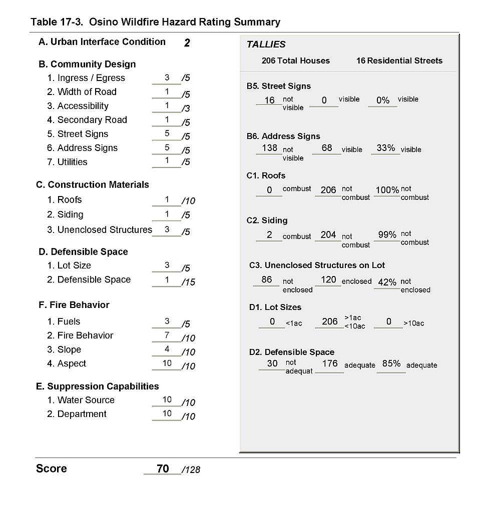 |
Figure 17-1Osino Fire History and Proposed Mitigation Projects |
 |
Figure 17-2Osino Classification of Fuel Hazard |
 |
Figure 17-3. Osino Fuel Hazard Photo Point
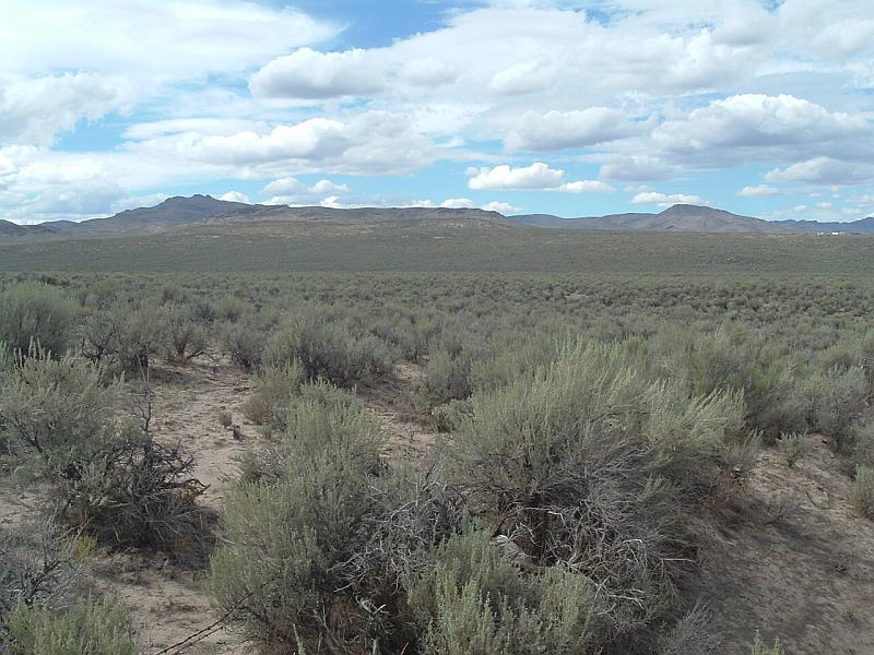
Photo Point 1. 4532071N, 0610976E, 320°NW. Vegetative fuels in the community consist primarily of shrubs three to four feet tall that include sagebrush and rabbitbrush. The fuel hazard was considered moderate on flat terrain.