![]()
![]()
18.0 Ruby Lake Estates
18.1 Risk and Hazard Assessment
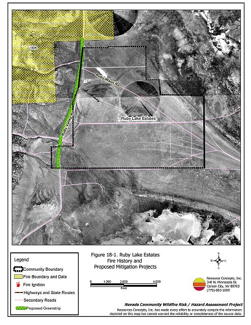
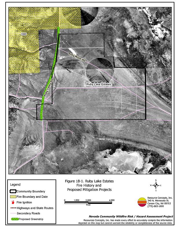
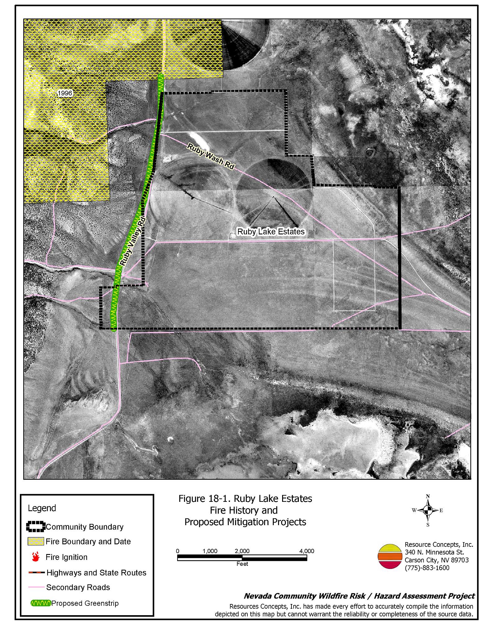
Ruby Lake Estates is located in the south portion of Ruby Valley, on the east side of Harrison Pass, and north of the junction with Ruby Valley Road. The community hazard assessment resulted in classifying the community in the High Hazard category (63 points). A summary of the factors that contributed to the hazard rating is included in Table 18-3. The primary factors that contributed to the rating were inadequate defensible space, unenclosed architectural features, and fire behavior factors related to fuels and topography. The community boundary identified for this report is shown in Figure 18-1.
18.1.1 Community Design
Ruby Lake Estates has an intermix wildland-urban interface condition. Structures are scattered throughout the community with no clear line of demarcation between structures and wildland fuels. All nine homes included in the assessment are on parcels of one to ten acres in size.
- Access: Ruby Valley Road is the only transportation route through Ruby Lake Estates. The road is twenty to 24 feet wide and has adequate turnaround space for fire suppression equipment to maneuver. There are some secondary roads in an area planned for future growth.
- Signage: Street signs are clearly posted on all streets in the community. Residential addresses are not clearly visible on any of the homes. Clear and visible street signs and residential addresses are important in locating homes during low visibility conditions that occur during a wildfire.
- Utilities: All of the utilities are above ground. Power line corridors have been properly maintained to minimize wildfire damage to electric utilities and reduce the possibility that sparks could start a fire in adjacent vegetation.
18.1.2 Construction Materials
Eighty-nine percent of the homes observed in the interface area are built with non-combustible or highly fire resistant siding materials such as medium density fiberboard, and fire resistant roofing materials such as composition roofing, metal, or tile. Just over half of the homes had unenclosed porches, decks, or balconies that create drafts and provide areas where sparks and embers can be trapped, smolder, ignite, and rapidly spread fire to the house.
18.1.3 Defensible Space
Nearly half of the homes in the community do not meet the minimum recommended defensible space requirement to help protect the home from damage or loss during a wildfire.
18.1.4 Suppression Capabilities
Wildfire Protection Resources
Fire protection in Ruby Lake Estates is provided by the Ruby Valley Volunteer Fire Department. The department has several stations situated throughout the valley with seventeen volunteers and one chief. The Ruby Valley National Wildlife Refuge has three full time staff and three seasonal paid staff members. The Nevada Department of Wildlife Gallagher Fish Hatchery has equipment and trained staff as well. Additional resources are available through the Bureau of Land Management Elko Field Office and the Nevada Division of Forestry as requested. Table 18-1 lists the types of wildfire resources, cooperating partners, and equipment available for initial response to Ruby Lake Estates in the event of a reported wildfire. Additional resources are available from local, state, and federal agencies through mutual aid agreements as described in Section 4.1.1.
| Type of Equipment | Amount of Equipment | Cooperating Partner (Resource Location) |
|---|---|---|
| Type 6 Engine | 2 | Ruby Valley VFD (Secret Pass) |
| Type 3 Engine Water Tender |
1 1 |
Ruby Valley VFD School Station (Ruby Valley) |
| Type 6 Engine Type 3 Engine |
1 1 |
Nevada Department of Wildlife (Gallagher Fish Hatchery) |
| Type 4 Engine Water Tender |
1 1 |
Ruby Valley National Wildlife Refuge (Ruby Valley) |
| Type 2 Engine | 1 | Spring Creek VFD (Station #1) |
| Type 6 Engine | 1 | Nevada Division of Forestry (Wells - seasonal) |
| Type 4 Engine | 1 | Bureau of Land Management (Wells) |
| Type 6 Engine | 1 | US Forest Service (Wells) |
| Source: Sam Hicks, Nevada Division of Forestry Elko County Prevention Captain; Larry Burton, Ruby Valley VFD Fire Chief. | ||
Water Sources and Infrastructure
Water available for fire suppression resources for Ruby Lake Estates includes three 10,000-gallon underground water storage tanks with one drafting hydrant for a total of 30,000-gallons. Several irrigation wells and wheel lines in the valley are equipped with fire hose connections to fill fire apparatus.
Fire Protection Personnel Qualifications
The Ruby Valley volunteers have received training from the Nevada Division of Forestry and cooperating agencies to meet the minimum National Wildfire Coordinating Group basic wildland standards.
Work Load
In a typical year the Ruby Valley VFD responds to the following annual calls:
- Three to four emergency medical calls.
- Six to twelve wildland/brush fire calls.
- Six other calls.
18.1.5 Factors Affecting Fire Behavior
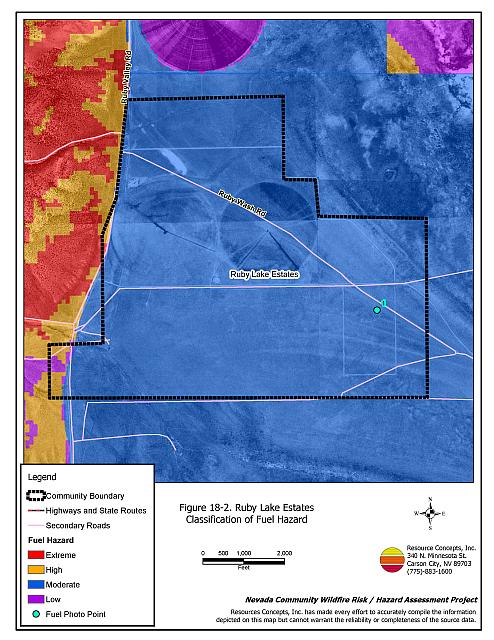
The vegetative fuel hazard in the Ruby Lake Estates interface area is generally low to moderate, with fuel loads estimated at one to four tons per acre. Fuels in the community consist primarily of a shrub layer of big sagebrush and rabbitbrush. Ground fuels consist of perennial grasses and cheatgrass, an invasive annual grass that establishes on burned sites. Cheatgrass production is dependent on annual moisture and will increase in years of high precipitation. On slopes west of the community, the presence of pinyon and juniper trees increase the fuel load to between six and eight tons per acre. The fuel hazard was considered high to extreme on the west side of Ruby Valley Road.
The terrain within the community boundary is steep to the west of the community where Harrison Pass opens into Ruby Valley. Several canyons and drainages extend out of the mountains in close proximity to the community. The prevailing winds are downslope from the mountains and are erratic with unpredictable direction. There is a history of afternoon thunderstorms and dry lightning strikes in the area.
18.1.6 Fire Behavior Worst Case Scenario
The worst-case scenario for a wildfire in the area surrounding Ruby Lake Estates would be a dry lightning storm west of the community upslope in pinyon-juniper and annual grass fuels. Erratic downslope winds would drive the fire toward residences. The community is somewhat protected because it is situated on the east side of the County Road and the road creates a fuel break. Initial response from fire suppression resources could be an hour or more away dependent on availability during normal working hours.
18.1.7 Ignition Risk Assessment
Ruby Lake Estates was determined to have a high risk of ignition based on fire history in the area and the potential for increased fuel loading from annual grass in high precipitation years. There is some wildfire history surrounding the community and a history of lightning strikes around the community. The primary risk of ignition in Ruby Lake Estates is lightning, although human caused ignitions are unpredictable and can occur at any time.
18.2 Risk and Hazard Reduction Recommendations
The responsibility to keep a community fire safe falls not only on the local fire protection district but also on the residents and local governments. The recommendations for the Ruby Lake Estates area focus primarily on the ongoing and additional efforts to create and maintain defensible space and on the community coordination and public education efforts that could be undertaken to enhance fire safety.
18.2.1 Defensible Space Treatments
Defensible space treatments are an essential first line of defense for residential structures. The goal of the treatments is to significantly reduce or remove flammable vegetation within a prescribed distance from structures. (Refer to Appendix E for the minimum recommended defensible space area). Defensible space reduces the fire intensity and improves firefighter and homeowner chances for successfully defending a structure against an oncoming wildfire.
Property Owners Recommendations
- Remove, reduce, and replace vegetation around homes according to the guidelines in Appendix E. This area should be kept:
- Lean: There are only small amounts of flammable vegetation.
- Clean: There is no accumulation of dead vegetation or other flammable debris.
- Green: Existing plants are healthy and green during the fire season.
- Store firewood a minimum distance of thirty feet from structures.
- Remove all dead vegetation and other flammable materials a minimum of five feet from the exterior of the structure.
- Maintain areas under wood decks and porches free of weeds and other flammable debris. Enclose these areas when possible. Box in eves and cover attic and other ventilation openings with very fine metal wire mesh to prevent embers from entering the attic or crawl space.
- Clear all vegetation and combustible materials around propane tanks for a minimum distance of ten feet.
- Immediately dispose of cleared vegetation when implementing defensible space treatments. This material dries quickly and poses a fire hazard if left on site.
- Where cheatgrass has become dominant within the defensible space zone, areas should be mowed prior to seed maturity or treated with an application of a pre-emergent herbicide. Treatments may need to be repeated for several years to ensure that the seed bank of unwanted annual grass seeds has been depleted. Refer to Appendix E for a recommended seed mixture and planting guidelines that can be used in conjunction with cheatgrass removal.
- Install spark arrestors on chimneys.
- Create defensible space around all wellheads for easy access and to protect the wellhead from damage in the event of a wildfire.
18.2.2 Fuels Reduction Treatments
Fuel reduction treatments are applied on a larger scale than defensible space treatments. Permanently changing the fuel characteristics over large blocks of land to one of a lower volume and one of altered distribution reduces the risk of a catastrophic wildfire in the treated area. Reducing vegetation along roadways and driveways could reduce the likelihood of blocking access and escape routes, help contain the fire perimeter, and improve firefighter access and safety for protecting homes.
Elko County
- Clear and maintain free of vegetation a minimum space of fifty feet from the edge of road on both sides of Smith Canyon Drive by mowing to a height of four inches on both sides of road. This fuel reduction treatment is to extend from the County road east to Griswold.
- Construct a greenstrip by clearing vegetation 100 feet from the edge of the road on the west side and fifty feet on the east side of Ruby Valley Road for a distance of approximately 1.5 miles as shown in Figure 18-1.
- Reduce vegetation and maintain community roads by mowing all vegetation to a height of no more than four inches for a distance of twenty feet from the edge of the road on both sides of the road.
Nevada Division of Forestry
- Create a defensible space zone of 100 feet around the wellhead of the irrigation well used as a fire suppression water source (located one mile east of the community at County Road and CCC Road intersection). Clearly mark the standpipe for easy visibility.
18.2.3 Fire Suppression Resources
Ruby Valley VFD Nevada Division of Forestry
- Continue to provide wildland firefighting training and Firefighter I training for all volunteers.
- Work with Elko County and the State of Nevada to create incentives for recruiting and retaining volunteers.
- Upgrade the VFD radio system to narrow band technology to ensure proper communication compatibility with cooperating agencies.
- Clearly mark and map all underground tanks and drafting hydrants in the community including the agricultural well.
18.2.4 Community Coordination
Property Owners
- Form a local community-based organization to take responsibility and provide leadership for community-wide fuels reduction and community fire safety. The Nevada Fire Safe Council is one option for community organization. Through the establishment of a local Nevada Fire Safe Council Chapter, local communities will become part of a large network for sharing information, including notification of programs and funding opportunities for fire mitigation projects such as those listed in this report. The Nevada Fire Safe Council will accept and manage grants and contracts on the Chapter’s behalf through its non-profit status. The Nevada Fire Safe Council will provide assistance and support to communities to complete fire safe plans, set priorities, educate and train community members, and promote success stories of its members. To form a local chapter or for more information contact the:
Nevada Fire Safe Council
210 South Roop Street Suite 101
Carson City, NV 89701
www.nvfsc.org - Ensure residential addresses are easily visible from the road. Address characters should be at least four inches high, reflective on a dark background, and made of non-flammable material. Improving visibility of addresses will make it easier for those unfamiliar with the area to navigate under smoky conditions during a wildfire.
18.2.5 Public Education
A public education program that explains fire safe measures in clear and emphatic terms will have an impact on residents of the wildland-urban interface. Informed community members will be more inclined to make efforts to effectively reduce wildfire hazards around their homes and neighborhoods.
Ruby Valley VFD and Nevada Division of Forestry
- Distribute copies of the publication “Living With Fire” to all property owners. This publication is free of charge. Copies can be requested from the University of Nevada Cooperative Extension.
18.3 Summary of Recommendations
| Involved Party | Recommended Treatment | Recommendation Description |
|---|---|---|
| Property Owners |
Defensible Space | Remove, reduce, and replace vegetation around homes, equipment, and hay storage areas according to the guidelines in Appendix E. Maintain the defensible space annually. |
| Community Coordination | Form a local community-based organization to provide leadership and be responsible for community-wide fuels reduction and community fire safety. Ensure residential addresses are easily visible from the road. |
|
| Elko County | Fuels Reduction | Clear and maintain free of vegetation a minimum space of fifty feet from the edge of the road on both sides of Smith Canyon Drive by mowing to a height of four inches on both sides of the road. This fuel reduction treatment is to extend from the County road east to Griswold, as detailed on Figure 18-1. Clear vegetation 100 feet from the edge of the road on the west side and fifty feet on the east side of Ruby Valley Road as it runs through the community. Reduce vegetation and maintain community roads by mowing all vegetation to a height of no more than four inches for a distance of twenty feet from the edge of the road on both sides of the road. |
| Ruby Valley VFD and Nevada Division of Forestry |
Fuels Reduction | Create a defensible space zone of 100 feet around the wellhead of the irrigation well used as a fire suppression water source. Clearly mark the standpipe for easy visibility. |
| Fire Suppression Resources | Continue to provide wildland firefighting training and Firefighter I training for all volunteers. Work with Elko County and the State of Nevada to create incentives for recruiting and retaining volunteers. Upgrade the VFD radio system to narrow band technology to ensure proper communication compatibility with cooperating agencies. Clearly mark and map all underground tanks and drafting hydrants in the community including the agricultural well. |
|
| Public Education | Distribute copies of the publication “Living With Fire” to all property owners. |
Table 18-3Ruby Lake Estates Wildfire Hazard Rating Summary |
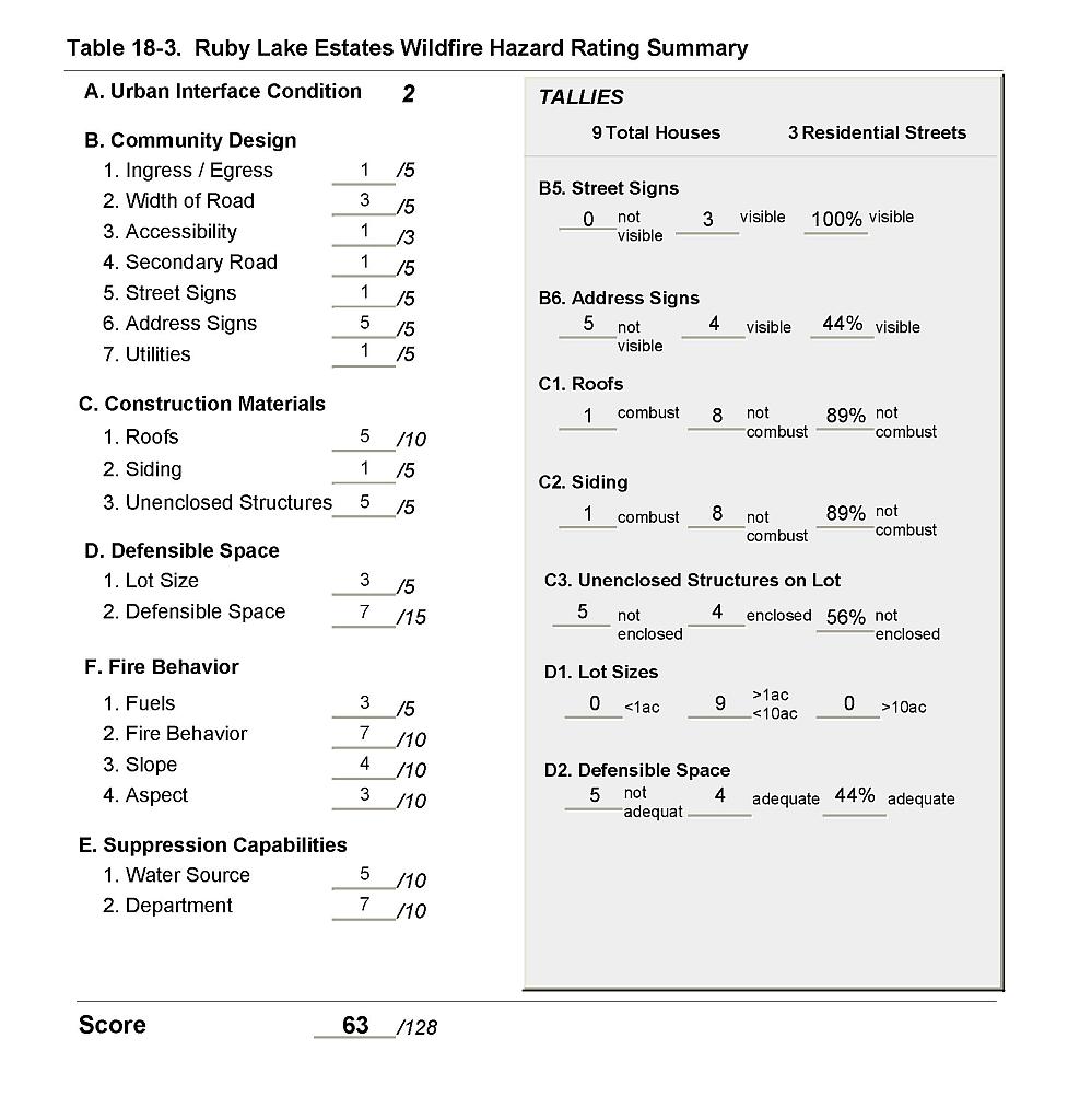 |
Figure 18-1Ruby Lake Estates Fire History and Proposed Mitigation Projects |
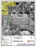 |
Figure 18-2Ruby Lake Estates Classification of Fuel Hazard |
 |
Figure 18-3. Ruby Lake Estates Fuel Hazard Photo Point
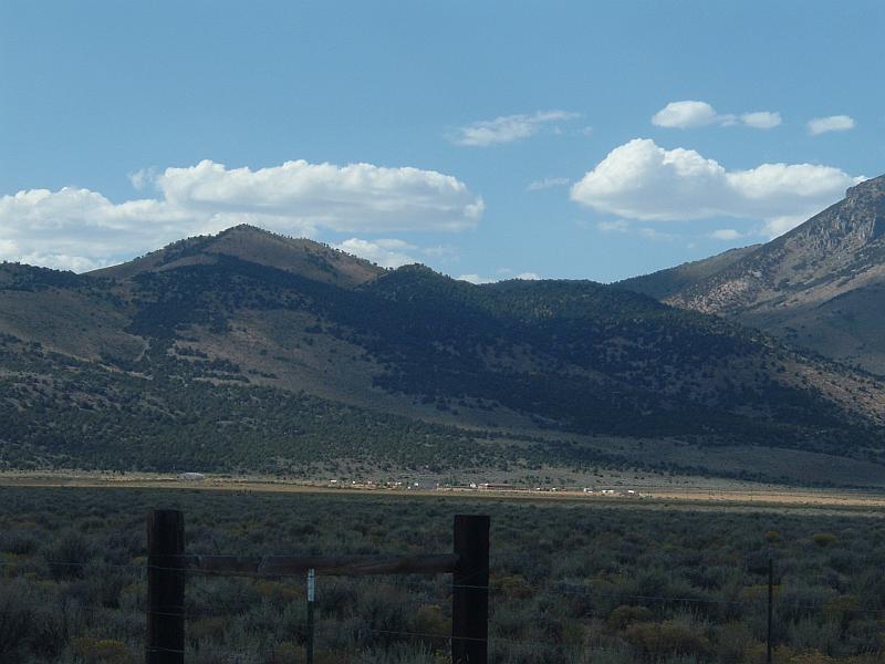
Photo Point 1. 446393N, 0632091E, 290°NW. Vegetative fuels in the community consist primarily of big sagebrush, rabbitbrush, perennial grasses, and cheatgrass. The fuel hazard was considered moderate and fuel loads estimated at one to four tons per acre.