![]()
![]()
19.0 Ten Mile
19.1 Risk and Hazard Assessment
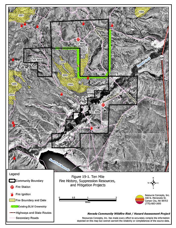
Ten Mile is a small community located west of State Route 228 approximately ten miles south of Elko. It is situated at an elevation of approximately 5,000 feet on the north side of South Fork Reservoir at the South Fork State Recreation Area. The community hazard assessment resulted in classifying Ten Mile in the High Hazard category (66 points). A summary of the factors that contributed to the hazard rating is included in Table 19-3. The primary factors that contributed to the rating were the lack of street and address signage, fire behavior factors related to fuels and topography, and limited fire suppression resources. The community boundary identified for this report is shown in Figure 19-1.
19.1.1 Community Design
Ten Mile has an intermix wildland-urban interface condition. The community is made up of homes on parcels that are one acre or larger. Structures are scattered throughout the community with no clear line of demarcation between structures and wildland fuels. There were 67 homes included in the assessment.
- Access: Ten Mile is accessed by small community roads that lead from State Route 228. Some of the secondary roads are inadequate for fire suppression equipment access and two-vehicle passage.
- Signage: Street signs are not visibly posted in Ten Mile. Addresses are not clearly visible on any of the homes. Clear and visible street signs and residential addresses are important in locating homes during low visibility conditions that occur during a wildfire.
- Utilities: All of the utilities are above ground. Power line corridors need proper maintenance to minimize wildfire damage to electric utilities and reduce the possibility that sparks could start a fire in adjacent vegetation.
19.1.2 Construction Materials
Ninety-nine percent of the homes observed in the interface area are built with non-combustible or highly fire resistant siding materials such as medium density fiberboard. Ninety-seven percent of the homes have fire resistant roofing materials such as composition roofing, metal, or tile. Twenty-one percent of the homes have unenclosed porches, decks, or balconies that create drafts and provide areas where sparks and embers can be trapped, smolder, ignite, and rapidly spread fire to the house.
19.1.3 Defensible Space
Less than seventy percent of homes observed in the interface meet the minimum recommended defensible space requirement to help protect the home from damage or loss during a wildfire.
19.1.4 Suppression Capabilities
Wildfire Protection Resources
Fire protection in Ten Mile is provided by the Ten Mile Volunteer Fire Department. The VFD has two stations and thirteen volunteers. Table 19-1 lists the types of local wildfire resources, cooperating partners, and equipment available to Ten Mile in the event of a reported wildfire. Additional resources are available from local, state, and federal agencies through mutual aid agreements as described in Section 4.1.1.
| Type of Equipment | Amount of Equipment | Cooperating Partner (Resource Location) |
|---|---|---|
| Type 2 Engine Type 4 Engine Type 6 Engine Type 2 Water Tender Type 1 Water Tender |
2 1 2 1 2 |
Ten Mile VFD (Ten Mile) |
| Type 2 Engine |
1 |
Spring Creek Station 1 (Spring Creek) |
| Source: Sam Hicks, Nevada Division of Forestry Elko County Prevention Captain; Blake O’Donnell, Ten Mile VFD Fire Chief. | ||
Water Sources and Infrastructure
Water available for fire suppression in Ten Mile includes community wells. Additional drafting sites for fire suppression include Ten Mile Creek, South Fork Reservoir, and a pond one mile away. There is one hydrant located at the South Fork State Park and one dry hydrant on Ten Mile Creek.
Fire Protection Personnel Qualifications
The Ten Mile volunteers have received training from the Nevada Division of Forestry and cooperating agencies to meet the minimum National Wildfire Coordinating Group basic wildland standards.
Work Load
In a typical year the Ten Mile VFD responds to the following annual calls:
- Ten to fifteen emergency medical calls.
- Fifteen to twenty wildland/brush fire calls.
19.1.5 Factors Affecting Fire Behavior
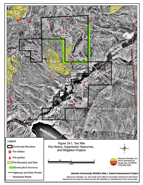
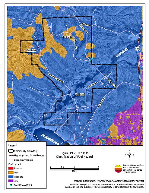
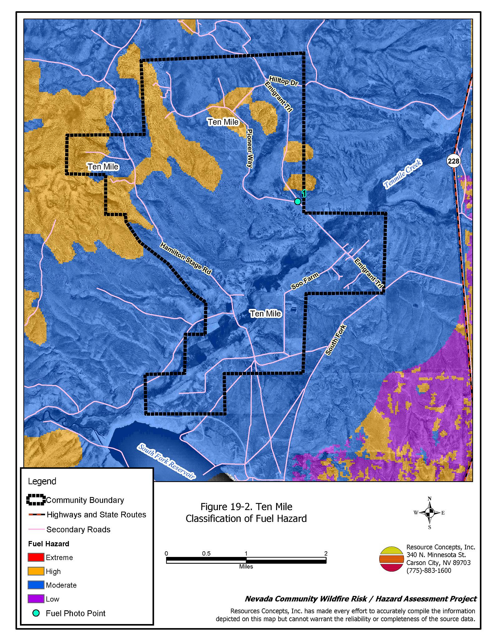
The vegetative fuel density and fuel hazard throughout much of the Ten Mile interface area is generally moderate, estimated at two to four tons per acre. Fuels in the community consist primarily of sagebrush, and rabbitbrush. Ground fuels include perennial grasses, halogeton, and cheatgrass. Cheatgrass growth is dependent on annual moisture and will produce increased fuel volumes in years of higher than average precipitation. Higher fuel hazards are attributed to an increased occurrence of juniper at higher elevations. In areas that have previously burned, crested wheatgrass is the dominant species intermixed with sagebrush and rabbitbrush. The terrain within the community boundary is generally gently sloping, although some slopes reach twenty percent. The prevailing wind direction is from the south/southwest. There is a history of afternoon thunderstorms and dry lightning strikes in the area and a history of large fires.
The Bureau of Land Management Elko Field Office constructed a greenstrip along the southwest and east sides of the Ten Mile community in 2004 (Figure 19-1). Sagebrush fuels were removed within a minimum 300-foot wide treatment area. The treatment area was seeded with perennial grass species. During the summer of 2005, the BLM maintained the greenstrip by mowing the quickly established seeding.
19.1.6 Fire Behavior Worst Case Scenario
The worst-case scenario for a wildfire in the area surrounding Ten Mile would come from a dry lightning storm on a summer day in a year with normal to above normal precipitation and high annual grass and forb production. Multiple fire ignitions south and west of the community area with strong erratic winds could push fires through the community.
19.1.7 Ignition Risk Assessment
Ten Mile has a high ignition risk based on fire history in the area, and the potential for increased fuel loading from annuals in high precipitation years. There is an extensive wildfire history in the public lands surrounding the community and a history of lightning strikes around the community. The primary risk of ignition in Ten Mile is lightning, although human caused ignitions are unpredictable and can occur at any time.
19.2 Risk and Hazard Reduction Recommendations
The responsibility to keep a community fire safe falls not only on the local fire protection district but also on the residents and local governments. The recommendations for the Ten Mile area focus primarily on the ongoing and additional efforts to create and maintain defensible space and on the community coordination and public education efforts that could be undertaken to enhance fire safety.
19.2.1 Defensible Space Treatments
Defensible space treatments are an essential first line of defense for residential structures. The goal of the treatments is to significantly reduce or remove flammable vegetation within a prescribed distance from structures. (Refer to Appendix E for the minimum recommended defensible space area). Defensible space reduces the fire intensity and improves firefighter and homeowner chances for successfully defending a structure against oncoming wildfire.
Property Owners Recommendations
- Remove, reduce, and replace vegetation around homes, outbuildings, and equipment and hay storage areas, according to the guidelines in Appendix E. This area should be kept:
- Lean: There are only small amounts of flammable vegetation.
- Clean: There is no accumulation of dead vegetation or other flammable debris.
- Green: Existing plants are healthy and green during the fire season.
- Store firewood a minimum distance of thirty feet from structures.
- Remove all dead vegetation and other flammable materials a minimum of five feet from the exterior of the structure.
- Clear all vegetation and combustible materials around propane tanks for a minimum distance of ten feet.
- Mow or remove brush growing against fences in the community. The minimum distance for clearance should be ten feet in grass and 25 feet in brush.
- Immediately dispose of cleared vegetation when implementing defensible space treatments. This material dries quickly and poses a fire hazard if left on site.
- Where cheatgrass has become dominant within the defensible space zone, areas should be mowed prior to seed maturity or treated with an application of a pre-emergent herbicide. Treatments may need to be repeated for several years to ensure that the seed bank of unwanted annual grass seeds has been depleted. Refer to Appendix E for a recommended seed mixture and planting guidelines that can be used in conjunction with cheatgrass removal.
- Maintain the defensible space as needed.
19.2.2 Fuel Reduction Treatments
Fuel reduction treatments are applied on a larger scale than defensible space treatments. Permanently changing the fuel characteristics over large blocks of land to one of a lower volume and one of altered distribution reduces the risk of a catastrophic wildfire in the treated area. Reducing vegetation along roadways and driveways could reduce the likelihood of blocking access and escape routes, help contain the fire perimeter, and improve firefighter access and safety for protecting homes.
Ten Mile VFD and Nevada Division of Forestry
- Coordinate additional shrub thinning treatments on private lands throughout the community, especially in areas that have not previously burned. Thin shrubs to reduce overall shrub density by fifty percent.
Elko County
- Continue to reduce vegetation and maintain roads by mowing all vegetation to a height of no more than four inches for a distance of twenty feet from the edge of the road on both sides of the road. Remove and dispose of biomass at an appropriate site. Reseed treated areas with fire resistant species such as recommended in Appendix E to minimize cheatgrass and noxious weed invasion.
Utility Company
- Reduce and remove vegetation to maintain clearance around power lines. Clear vegetation within fifteen feet of utility poles near the community.
19.2.3 Fire Suppression Resources
Ten Mile VFD and Nevada Division of Forestry
- Upgrade the VFD radio system to narrow band technology to ensure proper communication compatibility.
- Continue to meet annually with the cooperating agencies to review pre-attack plans for the area.
19.2.4 Community Coordination
Property Owners
- Ensure residential addresses are easily visible from the road. Address characters should be at least four inches high, reflective on a dark background, and made of non-flammable material. Improving visibility of addresses will make it easier for those unfamiliar with the area to navigate under smoky conditions during a wildfire.
19.2.5 Public Education
A public education program that explains fire safe measures in clear and emphatic terms will have an impact on residents of the wildland-urban interface. Informed community members will be more inclined to make efforts to effectively reduce wildfire hazards around their homes and neighborhoods.
Ten Mile VFD
- Distribute copies of the publication “Living With Fire” to all property owners. This publication is free of charge. Copies can be requested from the University of Nevada Cooperative Extension.
19.3 Summary of Recommendations
| Involved Party | Recommended Treatment | Recommendation Description |
|---|---|---|
| Property Owners |
Defensible Space | Remove, reduce, and replace vegetation around homes, equipment, and hay storage areas according to the guidelines in Appendix E. Maintain the defensible space as needed. |
| Community Coordination | Ensure residential addresses are easily visible from the road. | |
| Elko County | Fuels Reduction | Continue to reduce vegetation and maintain roads by mowing all vegetation to a height of no more than four inches for a distance of twenty feet from the edge of the road on both sides of the road. |
| Electric Utility | Fuels Reduction | Reduce and remove vegetation to maintain clearance around power lines. Clear vegetation within fifteen feet of utility poles near the community. |
| Ten Mile VFD and Nevada Division of Forestry | Fire Suppression Resources | Continue to meet annually with the cooperating agencies to discuss pre-attack plans for the community. Upgrade the VFD radio system to narrow band technology to ensure proper communication compatibility. |
| Public Education | Distribute copies of the publication “Living With Fire” to all property owners. |
Table 19-3Ten Mile Wildfire Hazard Rating Summary |
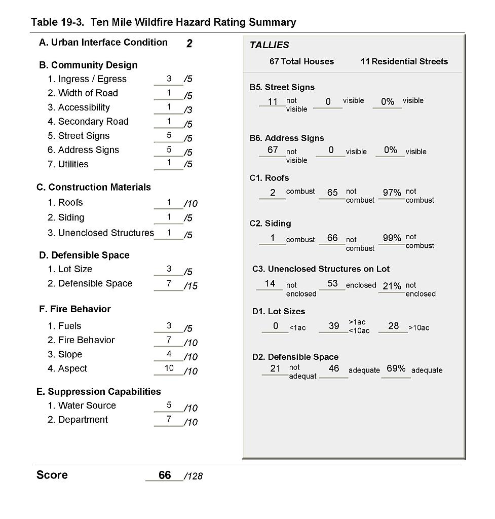 |
Figure 19-1Ten Mile Fire History, Suppression Resources, and Mitigation Projects |
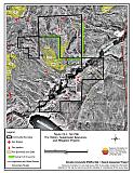 |
Figure 19-2Ten Mile Classification of Fuel Hazard |
 |
Figure 19-3. Ten Mile Fuel Hazard Photo Point
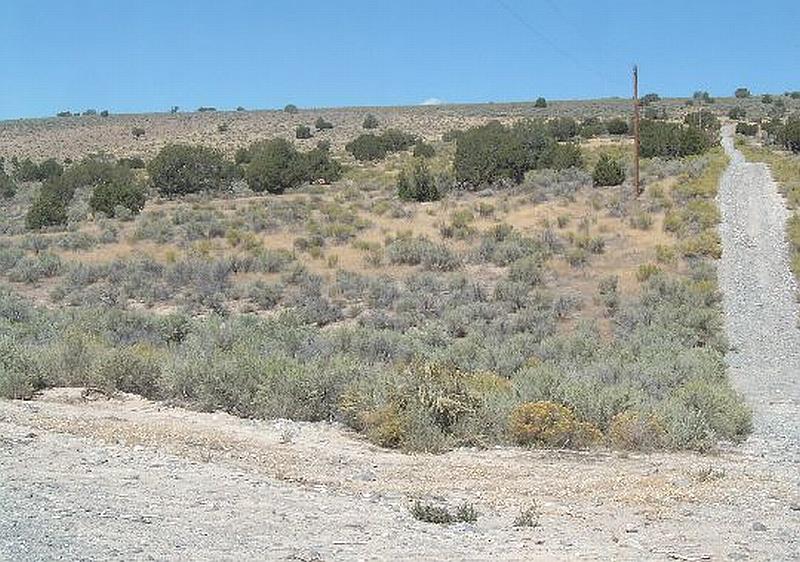
Photo Point 1. 4509121N, 606517E, 350°NE. Vegetative fuel loads in Ten Mile were considered a moderate hazard. Ground fuels in the community consist of cheatgrass, perennial grasses, and halogeton. Sagebrush and rabbitbrush are the dominant species in the shrub layer.