![]()
![]()
20.0 Tuscarora
20.1 Risk and Hazard Assessment
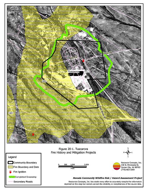
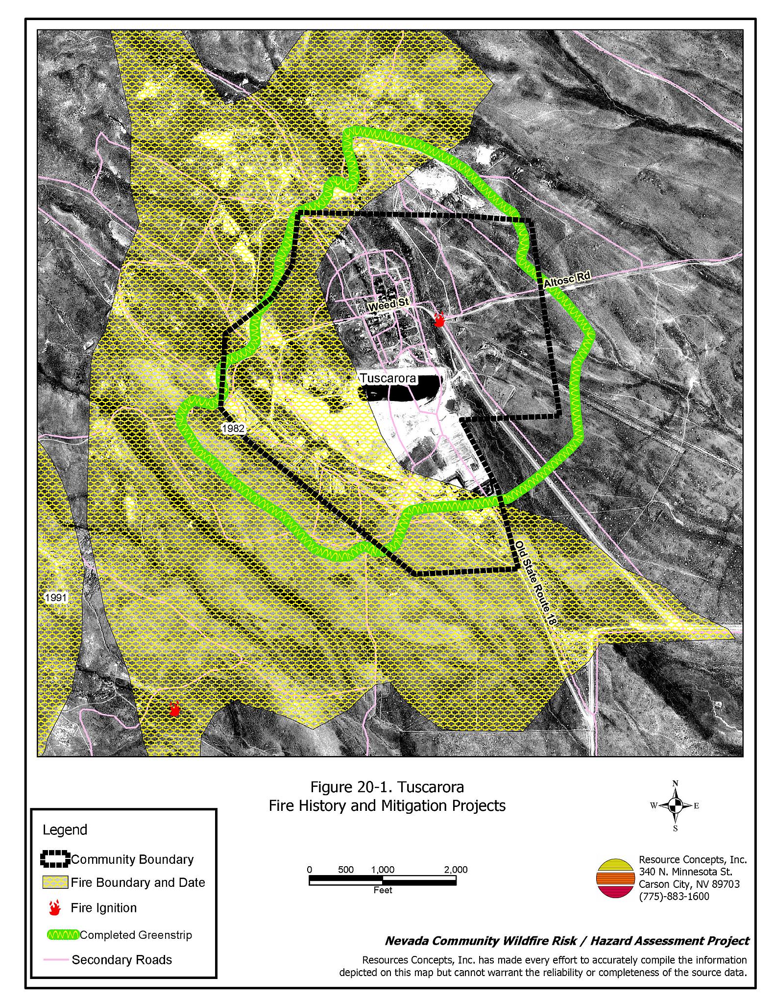
Tuscarora is a small community located approximately eight miles west of State Route 226 in Independence Valley which is in northwest Elko County. Tuscarora is situated at an elevation of approximately 6,100 feet. Tuscarora was founded as a mining town in 1867. Approximately twenty people currently reside in the community. The community hazard assessment resulted in classifying Tuscarora in the High Hazard category (67 points). A summary of the factors that contributed to the hazard rating is included in Table 20-3. The primary factors that contributed to the rating were inadequate signage and defensible space, limited fire protection, some construction factors, and topography. The community boundary identified for this report is shown in Figure 20-1.
20.1.1 Community Design
Tuscarora has an intermix wildland-urban interface condition. Structures are scattered throughout the community and in wildland fuels with no clear line of demarcation between structures and wildland fuels. All 27 homes included in the assessment are on lots of one acre or less.
- Access: Tuscarora is accessed by roads leading from State Route 226. The roads are between twenty to 24 feet wide and have adequate turnaround space for fire suppression equipment, although the majority of the roads are steeper than five percent grade.
- Signage: Street signs are clearly posted on two of the three community roads. Only one residence has a clearly visible address. Clear and visible street signs and residential addresses are important in locating homes during low visibility conditions that occur during a wildfire.
- Utilities: All of the utilities are above ground. Power line corridors need proper maintenance to minimize wildfire damage to electric utilities and reduce the possibility that sparks could start a fire in adjacent vegetation.
20.1.2 Construction Materials
Seventy percent of the homes observed in the interface area are built with non-combustible or highly fire resistant siding materials such as medium density fiberboard. All of the homes have fire resistant roofing materials such as composition roofing, metal, or tile. Fifteen percent of the homes have unenclosed porches, decks, or balconies that create drafts and provide areas where sparks and embers can be trapped, smolder, ignite, and rapidly spread fire to the house.
20.1.3 Defensible Space
Seventy percent of the homes observed meet the minimum recommended defensible space requirement to help protect the home from damage or loss during a wildfire. The greatest fuel threat within the community is from homes with inadequate defensible space and from the numerous old, weathered buildings in town.
20.1.4 Suppression Capabilities
Wildfire Protection Resources
Fire protection in Tuscarora is provided by the Independence Valley Volunteer Fire Department, staffed by ten volunteers. Table 20-1 lists the types of local wildfire resources and equipment available for initial response to Tuscarora in the event of a reported wildfire. Additional resources are available from local, state, and federal agencies through mutual aid agreements as described in Section 4.1.1.
| Type of Equipment | Amount of Equipment | Cooperating Partner (Resource Location) |
|---|---|---|
| Type 3 Engine Type 6 Engine |
1 1 |
Independence Valley VFD (Independence Valley) |
| Type 3 Engine Type 1 Water Tender |
1 1 |
Nevada Division of Forestry (Elko) |
| Type 4 Engine | 1 | Bureau of Land Management (Elko) |
| Type 6 Engine | 1 | US Forest Service (Mountain City) |
| Source: Sam Hicks, Nevada Division of Forestry Elko County Prevention Captain; Jay Wright, Independence Valley VFD Fire Chief. | ||
The Independence Valley VFD has some old, outdated equipment (1977 Dodge 4x4 and a 1974 6x6). It is important that fire suppression equipment be adequate and in proper working condition in order for fire protection personnel to be able to protect the community in the event of a wildfire.
Water Sources and Infrastructure
Water available for fire suppression in Tuscarora includes:
- Hydrants within 500 feet of structures with a flow of approximately 300gpm.
- One well at the Independence Valley Fire Station.
- Two gravity-fed water storage tanks totaling 129,000 gallons.
Ranch ponds in the area could be used as draft sources. There is also a large mine pond at the south end of the community.
Fire Protection Personnel Qualifications
The Independence Valley VFD firefighters have received training from the Nevada Division of Forestry and cooperating agencies to meet the minimum National Wildfire Coordinating Group basic wildland standards.
Work Load
The Independence Valley VFD responds to an annual average of two to three wildland/brush fire calls.
20.1.5 Factors Affecting Fire Behavior
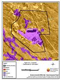
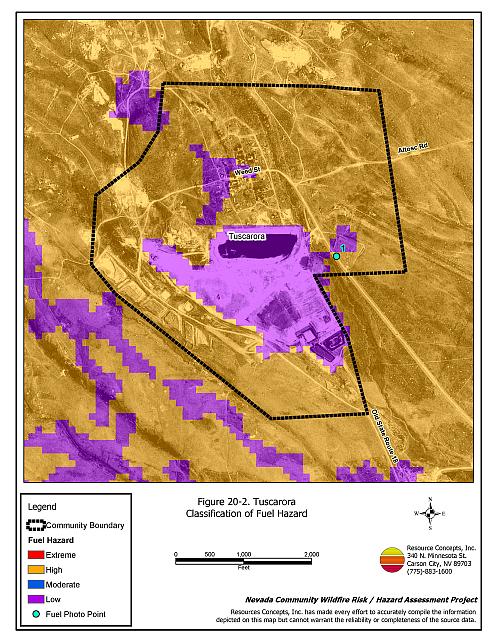
The vegetative fuel density in the Tuscarora interface area is light to moderate, with fuel loads estimated at one to three tons per acre. The fuel hazard is generally high within the community and surrounding the community. Fuels in the community consist primarily of big sagebrush and rabbitbrush, with perennial grasses and cheatgrass. Cheatgrass growth is dependent on annual moisture and will produce increased fuel volumes and elevated fuel hazard conditions in years of higher than average precipitation. Fuel hazard mapping is shown in Figure 20-2. Fuel hazard photo points are shown in Figure 20-3. Within the community boundary the topography varies from flat with south aspect slopes on the east side reaching twenty percent. The prevailing wind direction is from the south/southwest. There is a history of afternoon thunderstorms and dry lightning strikes in the area.
The Nevada Division of Forestry in conjunction with the Bureau of Land Management, Elko Field Office completed a 300-foot wide greenstrip near Tuscarora, as shown in Figure 20-1. The project implementation began in 2001 and was completed in June of 2003. Brush was removed using both mechanical mastication equipment and hand treatments. A rangeland drill was used to seed the greenstrip with crested wheatgrass. Control of whitetop (or Hoary cress) (Cardaria draba) using herbicide treatments was also completed.
20.1.6 Fire Behavior Worst Case Scenario
The worst-case scenario for a wildfire in the area surrounding Tuscarora would come from a dry lightning storm on a summer day in a year with normal to above normal precipitation and high annual grass and forb production. Multiple fire ignitions and strong erratic winds could push fires into the community from any direction. This historic community is at risk due to poor defensible space, old weathered historic buildings, an old water system, and additional suppression resources over two hours away.
20.1.7 Ignition Risk Assessment
Tuscarora has a high ignition risk based on fire history in the area and the potential for increased fuel loading from annuals in high precipitation years. There is an extensive wildfire history in the public lands surrounding the community and a history of lightning strikes around the community. The primary risk of ignition in Tuscarora is lightning, although human caused ignitions are unpredictable and can occur at any time.
20.2 Risk and Hazard Reduction Recommendations
The responsibility to keep a community fire safe falls not only on the local fire protection district but also on the residents and local governments. The recommendations for the Tuscarora area focus primarily on the ongoing and additional efforts to create and maintain defensible space and on the community coordination and public education efforts that could be undertaken to enhance fire safety.
20.2.1 Defensible Space Treatments
Defensible space treatments are an essential first line of defense for residential structures. The goal of the treatments is to significantly reduce or remove flammable vegetation within a prescribed distance from structures. (Refer to Appendix E for the minimum recommended defensible space area). Defensible space reduces the fire intensity and improves firefighter and homeowner chances for successfully defending a structure against oncoming wildfire.
Property Owners Recommendations
- Remove, reduce, and replace vegetation around homes according to the guidelines in Appendix E. This area should be kept:
- Lean: There are only small amounts of flammable vegetation.
- Clean: There is no accumulation of dead vegetation or other flammable debris.
- Green: Existing plants are healthy and green during the fire season.
- Store firewood a minimum distance of thirty feet from structures.
- Remove all dead vegetation and other flammable materials a minimum of five feet from the exterior of the structure.
- Clear all vegetation and combustible materials around propane tanks for a minimum distance of ten feet.
- Maintain areas under wood decks and porches free of weeds and other flammable debris. Enclose these areas when possible. Box in eves and cover attic and other ventilation openings with very fine metal wire mesh to prevent embers from entering the attic or crawl space.
- Immediately dispose of cleared vegetation when implementing defensible space treatments. This material dries quickly and poses a fire hazard if left on site.
- Where cheatgrass has become dominant within the defensible space zone, areas should be mowed prior to seed maturity or treated with an application of a pre-emergent herbicide. Treatments may need to be repeated for several years to ensure that the seed bank of unwanted annual grass seeds has been depleted. Refer to Appendix E for a recommended seed mixture and planting guidelines that can be used in conjunction with cheatgrass removal.
- Maintain the defensible space as needed.
20.2.2 Fuels Reduction Treatments
Fuel reduction treatments are applied on a larger scale than defensible space treatments. Permanently changing the fuel characteristics over large blocks of land to one of a lower volume and one of altered distribution reduces the risk of a catastrophic wildfire in the treated area. Reducing vegetation along roadways and driveways could reduce the likelihood of blocking access and escape routes, help contain the fire perimeter, and improve firefighter access and safety for protecting homes.
Elko County
- Reduce vegetation and maintain roads by mowing all vegetation to a height of no more than four inches for a distance of twenty feet from the edge of the road on both sides of the road. Remove and dispose of biomass at an appropriate site. Reseed treated areas with fire resistant species such as recommended in Appendix E to minimize cheatgrass and noxious weed invasion.
Electric Utility Company
- Reduce and remove vegetation to maintain clearance around power lines. Clear vegetation within fifteen feet of utility poles near the community.
20.2.3 Fire Suppression Resources
Independence Valley VFD and Nevada Division of Forestry
- Continue to meet annually with the cooperating agencies to review pre-attack plans for the area.
- Upgrade the VFD radio system to narrow band technology to ensure proper communication compatibility.
- Upgrade fire apparatus for the VFD.
20.2.4 Community Coordination
Property Owners
- Form a local community-based organization to take responsibility and provide leadership for community-wide fuels reduction and community fire safety. The Nevada Fire Safe Council is one option for community organization. Through the establishment of a local Nevada Fire Safe Council Chapter, local communities will become part of a large network for sharing information, including notification of programs and funding opportunities for fire mitigation projects such as those listed in this report. The Nevada Fire Safe Council will accept and manage grants and contracts on the Chapter’s behalf through its non-profit status. The Nevada Fire Safe Council will provide assistance and support to communities to complete fire safe plans, set priorities, educate and train community members, and promote success stories of its members. To form a local chapter or for more information contact the:
Nevada Fire Safe Council
210 South Roop Street Suite 101
Carson City, NV 89701
www.nvfsc.org - Ensure residential addresses are easily visible from the road. Address characters should be at least four inches high, reflective on a dark background, and made of non-flammable material. Improving visibility of addresses will make it easier for those unfamiliar with the area to navigate under smoky conditions during a wildfire.
20.2.5 Public Education
A public education program that explains fire safe measures in clear and emphatic terms will have an impact on residents of the wildland-urban interface. Informed community members will be more inclined to make efforts to effectively reduce wildfire hazards around their homes and neighborhoods.
Independence Valley VFD
- Distribute copies of the publication “Living With Fire” to all property owners. This publication is free of charge. Copies can be requested from the University of Nevada Cooperative Extension.
20.3 Summary of Recommendations
| Involved Party | Recommended Treatment | Recommendation Description |
|---|---|---|
| Property Owners |
Defensible Space | Remove, reduce, and replace vegetation around homes, equipment, and hay storage areas according to the guidelines in Appendix E. Maintain the defensible space annually. |
| Community Coordination | Form a local community-based organization to provide leadership and be responsible for community-wide fuels reduction and community fire safety. Ensure residential addresses are easily visible from the road. |
|
| Elko County | Fuels Reduction | Reduce vegetation and maintain roads by mowing all vegetation to a height of no more than four inches for a distance of twenty feet from the edge of the road on both sides of the road. |
| Utility Company | Fuels Reduction | Reduce and remove vegetation to maintain clearance around power lines. Clear vegetation within fifteen feet of utility poles near the community. |
| Independence Valley VFD and Nevada Division of Forestry | Fire Suppression Resources | Continue to meet annually with the cooperating agencies to discuss pre-attack plans for the community. Upgrade VFD radio system to narrow band technology to ensure proper communication compatibility. Upgrade fire apparatus. |
| Public Education | Distribute copies of the publication “Living With Fire” to all property owners. |
Table 20-3Tuscarora Wildfire Hazard Rating Summary |
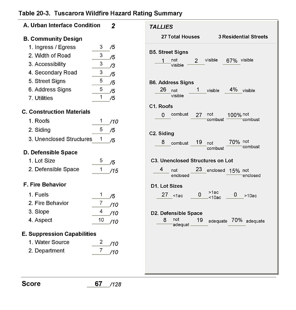 |
Figure 20-1Tuscarora Fire History and Mitigation Projects |
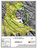 |
Figure 20-2Tuscarora Classification of Fuel Hazard |
 |
Figure 20-3. Tuscarora Fuel Hazard Photo Point
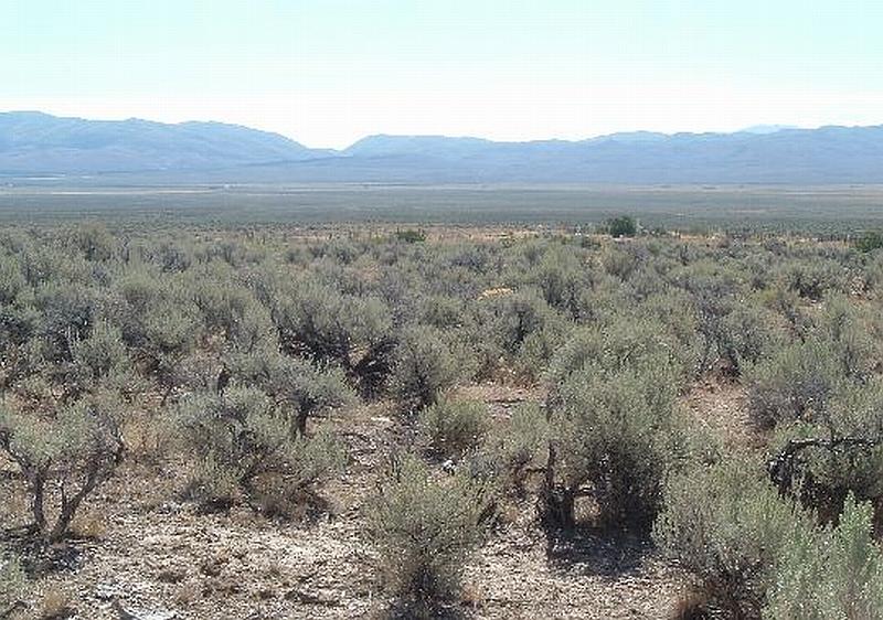
Photo Point 1. 4573614N, 565396E, 170°SE. Fuels in the community consist of sagebrush, rabbitbrush, cheatgrass, and perennial grasses that are two to four feet tall. The fuel loading is estimated at three tons per acre.