![]()
![]()
21.0 Carlin
21.1 Risk and Hazard Assessment
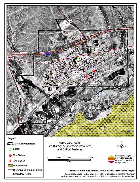
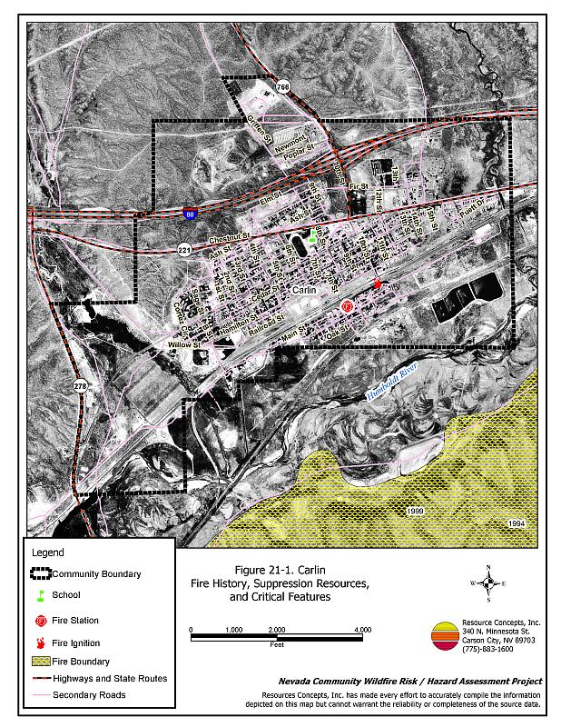
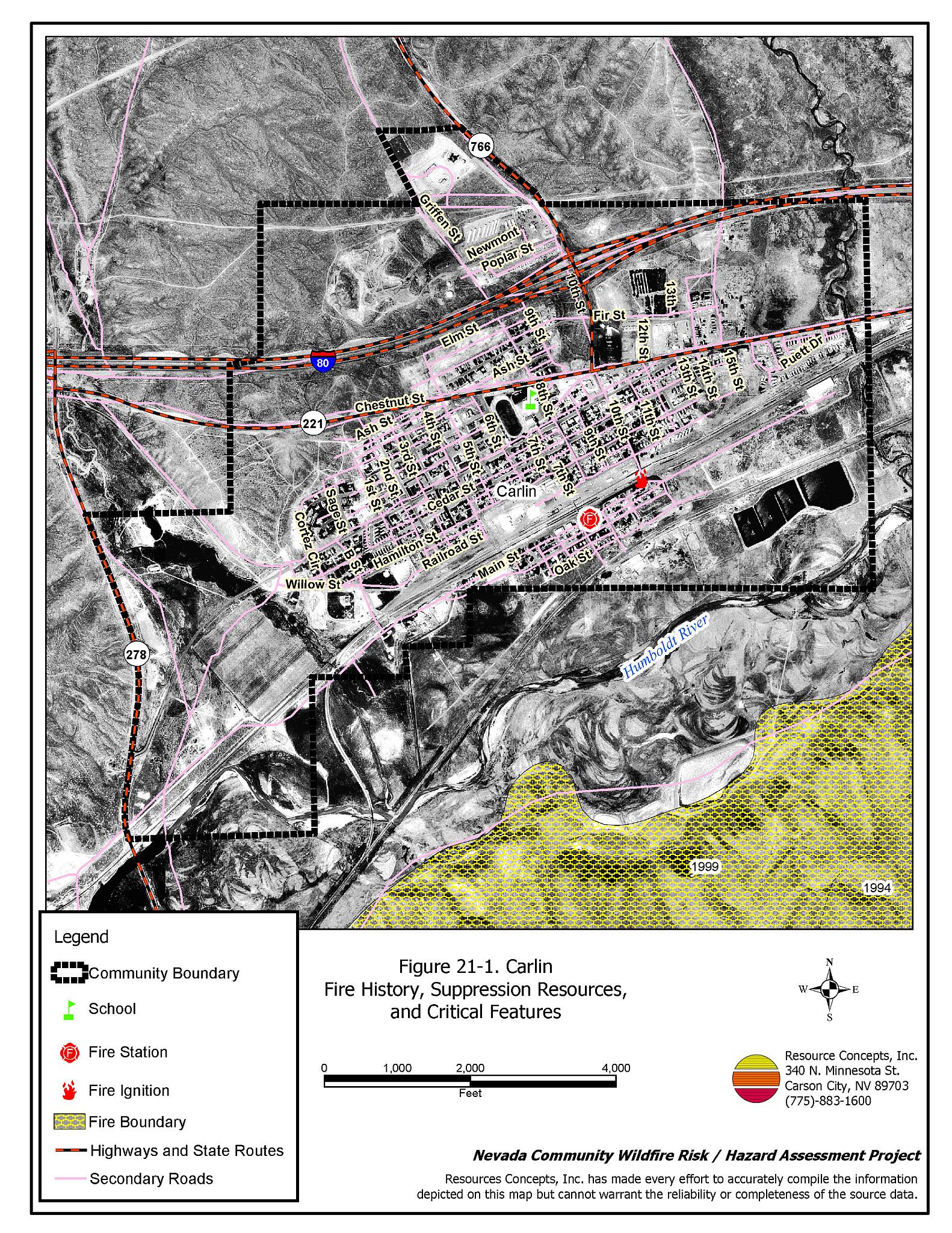
Carlin is a small community located in northeast Nevada, 23 miles west of Elko along Interstate 80, situated at an elevation of approximately 4,900 feet. The community hazard assessment resulted in classifying Carlin in the Moderate Hazard category (50 points). A summary of the factors that contribute to this hazard rating is included in Table 21-3. The moderate rating is primarily attributed to inadequate address visibility, inadequate defensible space, and the potential for difficult fire control resulting from high fire intensity. Fuel hazard mapping was reviewed for Carlin and the community was found to have areas of high or extreme fuel hazards. The community boundary identified for this report is shown in Figure 21-1.
21.1.1 Community Design
The wildland-urban interface surrounding Carlin is a classic interface condition: where property and structures abut wildland fuels a clear line of demarcation exists between residential areas and wildland fuels. Roads and back fences characteristically mark this type of interface and wildland fuels do not typically continue into developed areas. There were 172 homes included in the assessment. All of the homes are on parcels of one acre or less in size.
- Access: Interstate 80, State Route 766, and State Route 221 are the primary transportation routes to Carlin. There are numerous access routes into the community from these primary roads. All of the primary roads are at least 24 feet wide, paved, and have adequate turnaround space for fire suppression equipment.
- Signage: Street signs are clearly posted on all streets and addresses are clearly visible on three-quarters of the homes. Clear signage assists firefighters in locating homes during low visibility conditions that can occur during a wildfire.
- Utilities: All of the utilities are above ground. Power line corridors need proper maintenance to minimize wildfire damage to electric utilities and reduce the possibility that sparks could start a fire in adjacent vegetation.
21.1.2 Construction Materials
Ninety-seven percent of the homes observed in the interface area are built with non-combustible or highly fire resistant siding materials such as medium density fiberboard. All of the homes have fire resistant roofing materials such as composition roofing, metal, or tile. Approximately half of the homes have unenclosed porches, decks, or balconies that create drafts and provide areas where sparks and embers can be trapped, smolder, ignite, and rapidly spread fire to the house.
21.1.3 Defensible Space
Approximately one quarter of the homes do not meet the minimum recommended defensible space requirement to help protect the home from damage or loss during a wildfire.
21.1.4 Suppression Capabilities
Wildfire Protection Resources
Fire protection in Carlin is provided by the Carlin Volunteer Fire Department, which is staffed by 31 volunteers. Table 21-1 lists the types of local wildfire resources, cooperating partners, and equipment available for initial response to Carlin in the event of a reported wildfire. Additional resources are available from local, state, and federal agencies through mutual aid agreements as described in Section 4.1.1.
| Type of Equipment | Amount of Equipment | Cooperating Partner (Resource Location) |
|---|---|---|
| Type 3 Engine Type 6 Engine Water Tender |
2 1 1 |
Carlin VFD (Carlin) |
| Type 4 Engine | 3 | Bureau of Land Management (Carlin Station) |
| Type 6 Engine | 1 | Nevada Division of Forestry (Eureka County) |
| Source: Sam Hicks, Nevada Division of Forestry Elko County Prevention Captain; William Johnston, Carlin VFD Chief | ||
Water Sources and Infrastructure
Water available for fire suppression in Carlin includes fire hydrants within 500 feet of structures with minimum flow capacity of 500 gallons per minute. There are also four water storage tanks totaling over one million gallons, and a 200,000-gallon water tank at the UNR Fire Training Academy.
The community water system operates on gravity and electrical pumps. There are backup emergency generators to run the pumps in the event of an electrical power outage.
Fire Protection Personnel Qualifications
The Carlin volunteers have received training from the Nevada Division of Forestry and cooperating agencies to meet the minimum National Wildfire Coordinating Group basic wildland standards.
Work Load
The Carlin VFD responded to 225 calls in 2003:
- 150 emergency medical calls.
- 50 wildland/brush fire calls.
- 25 other calls.
21.1.5 Factors Affecting Fire Behavior
Fuels in the community primarily consist of rabbitbrush, sagebrush, cheatgrass, and Russian thistle in disturbed areas. Fuel loading is estimated at two to four tons per acre, with the heavier density fuels located in drainages west of the community and along the railroad. The fuel hazard is generally moderate; however, in the heavier density fuel areas the fuel hazard is high. Cheatgrass growth is dependent on annual moisture and will produce increased fuel volumes and elevate fuel hazard conditions in years of higher than average precipitation. The terrain within the community boundary is mostly flat with little or no slope; however, there are mountains to the south and north of the community. The prevailing wind direction is from the southwest and west. There is a history of afternoon thunderstorms and dry lightning strikes in the area.
21.1.6 Fire Behavior Worst Case Scenario
The worst-case scenario for a wildfire in the area surrounding Carlin would be a fire starting southwest of town along the railroad tracks with strong southwest winds pushing the fire through brush, annual grasses, and invasive weeds into structures. The town has many areas with heavy vegetation and extensive debris that could carry fire and threaten structures.
21.1.7 Ignition Risk Assessment
Carlin has a high risk of ignition based on fire history in the area and the potential for increased fuel loading from annual grasses in high precipitation years. The primary risks of ignition in Carlin are lightning, highway traffic, and the railroad.
21.2 Risk and Hazard Reduction Recommendations
The responsibility to keep a community fire safe falls not only on the local fire protection district but also on the residents, businesses, and local governments. The recommendations for the Carlin area focus primarily on the ongoing and additional efforts to create and maintain defensible space and on the community coordination and public education efforts that could be undertaken to enhance fire safety.
21.2.1 Defensible Space Treatments
Defensible space treatments are an essential first line of defense for residential structures. The goal of the treatments is to significantly reduce or remove flammable vegetation within a prescribed distance from structures. (Refer to Appendix F for the minimum recommended defensible space area). Defensible space reduces the fire intensity and improves firefighter and homeowner chances for successfully defending a structure against an oncoming wildfire.
Property Owners Recommendations
- Remove, reduce, and replace vegetation around homes according to the guidelines in Appendix E. This area should be kept:
- Lean: There are only small amounts of flammable vegetation.
- Clean: There is no accumulation of dead vegetation or other flammable debris.
- Green: Existing plants are healthy and green during the fire season.
- Store firewood a minimum distance of thirty feet from structures.
- Remove all dead vegetation and other flammable materials a minimum of five feet from the exterior of the structure.
- Mow or remove brush growing against fences in the community. The minimum distance for clearance should be ten feet in grass and 25 feet in brush.
- Maintain areas under wood decks and porches free of weeds and other flammable debris. Enclose these areas when possible. Box in eves and cover attic and other ventilation openings with very fine metal wire mesh to prevent embers from entering the attic or crawl space.
- Clear all vegetation and combustible materials around propane tanks for a minimum distance of ten feet.
- Immediately dispose of cleared vegetation when implementing defensible space treatments. This material dries quickly and poses a fire hazard if left on site.
- Where possible, irrigate all trees and large shrubs that remain in close proximity to structures to increase their fire resiliency. This is especially important during drought conditions.
- Trim and remove tree branches a minimum of four feet from the ground to reduce ladder fuels on all deciduous and coniferous trees within the defensible space zone. Prune all dead and diseased branches.
- Prune all tree branches to a minimum distance of fifteen feet from buildings, paying special attention to areas around chimneys.
- Mow grass within the defensible space zone to maintain a maximum height of four inches.
- Where cheatgrass has become dominant within the defensible space zone, areas should be mowed prior to seed maturity or treated with an application of a pre-emergent herbicide. Treatments may need to be repeated for several years to ensure that the seed bank of unwanted annual grass seeds has been depleted. Refer to Appendix E for a recommended seed mixture and planting guidelines that can be used in conjunction with cheatgrass removal.
- Install spark arrestors on chimneys.
- Board up or remove abandoned trailers and other structures to prevent ignition from sparks or firebrands.
21.2.2 Fuel Reduction Treatment
Fuel reduction treatments are applied on a larger scale than defensible space treatments. Permanently changing the fuel characteristics over large blocks of land to one of a lower volume and one of altered distribution reduces the risk of a catastrophic wildfire in the treated area. Reducing vegetation along roadways and driveways could reduce the likelihood of blocking access and escape routes, help contain the fire perimeter, and improve firefighter access and safety for protecting homes.
Carlin VFD and Nevada Division of Forestry
- Mow or otherwise remove all vegetation within ten feet of all fire hydrants to improve visibility and access for fire personnel.
- Develop and enforce brush clearance and biomass disposal programs.
Utility Company
- Reduce and remove vegetation to maintain clearance around power lines. Clear vegetation within fifteen feet of utility poles near the community.
Union Pacific Railroad
- Mow or reduce vegetation within a minimum distance of twenty feet on both sides of the railroad tracks. Reseed according to the recommendations in Appendix E, if necessary, to prevent cheatgrass or other noxious weed invasion. Maintain low growing, low-density fuel volumes within the railroad corridors to reduce the wildfire ignition risk and hazard.
- Clear all vegetation between the railroad tracks and structures along the railroad right-of-way.
21.2.3 Fire Suppression Resources
Carlin VFD and Nevada Division of Forestry
- Upgrade the VFD communication system to narrow band technology to assure communication compatibility.
- Continue to meet annually with the cooperating agencies to discuss pre-attack plans for the community.
- Develop a mutual aid agreement with the UNR Fire Training Academy in Carlin for response with a Type 1 engine.
21.2.4 Community Coordination
Carlin VFD and Nevada Division of Forestry
- Conduct courtesy inspections of defensible space condition and defensible space treatments on private property.
City of Carlin
- Continue to require all future development in the community to meet the National Fire Codes with regard to community design, building construction and spacing, road construction and design, water supply and emergency access. Refer to Appendix F for an example of fire safe recommendations for planning new developments.
- Promote cooperation between the Assessor’s Office and the Roads Department to ensure that all new development roads are named, mapped, signed, and identified with GPS locations.
Property Owners
- Ensure residential addresses are easily visible from the road. The best place to post an address is where the driveway meets the road. Address characters should be at least four inches tall and reflective on a dark background. Improving the visibility of addresses will facilitate the navigation of unfamiliar neighborhoods for rescue and suppression personnel during a wildfire event.
21.2.5 Public Education
A public education program that explains fire safe measures in clear and emphatic terms will have an impact on residents of the wildland-urban interface. Informed community members will be more inclined to make efforts to effectively reduce wildfire hazards around their homes and neighborhoods.
Carlin VFD and Nevada Division of Forestry
- Distribute copies of the publication “Living With Fire” to all property owners. This publication is free of charge. Copies can be requested from the University of Nevada Cooperative Extension.
| Involved Party | Recommended Treatment | Recommendation Description |
|---|---|---|
| Property Owners |
Defensible Space | Remove, reduce, and replace vegetation around homes according to the guidelines in Appendix E. Maintain the defensible space annually. |
| Community Coordination | Ensure residential addresses are easily visible from the road. | |
| Utility Company | Fuels Reduction | Reduce and remove vegetation to maintain clearance around power lines. Clear vegetation within fifteen feet of utility poles near the community. |
| Union Pacific Railroad | Fuels Reduction | Mow or reduce vegetation within a minimum distance of twenty feet on both sides of the railroad tracks. Clear all vegetation between the railroad tracks and structures along the railroad right-of-way. |
| City of Carlin | Community Coordination | Promote cooperation between the Assessor’s Office and the Roads Department to ensure that all new development roads are named, mapped, signed, and identified with GPS locations. Continue to require all future development in the County to meet the National Fire Codes with regard to community design, building construction and spacing, road construction and design, water supply and emergency access. |
| Carlin VFD and Nevada Division of Forestry | Fuels Reduction | Mow or otherwise remove all vegetation within ten feet of all fire hydrants to improve visibility and access for fire personnel. |
| Fire Suppression Resources | Upgrade the VFD communication system to narrow band technology to assure communication compatibility. Continue to meet annually with the cooperating agencies to discuss their pre-attack plan for the community. Develop a mutual aid agreement with the UNR Fire Training Academy in Carlin for response with a Type 1 engine. |
|
| Community Coordination | Conduct courtesy inspections of defensible space condition and defensible space treatments on private property. | |
| Public Education | Distribute copies of the publication “Living With Fire” to all property owners. |
Table 21-3Carlin Wildfire Hazard Rating Summary |
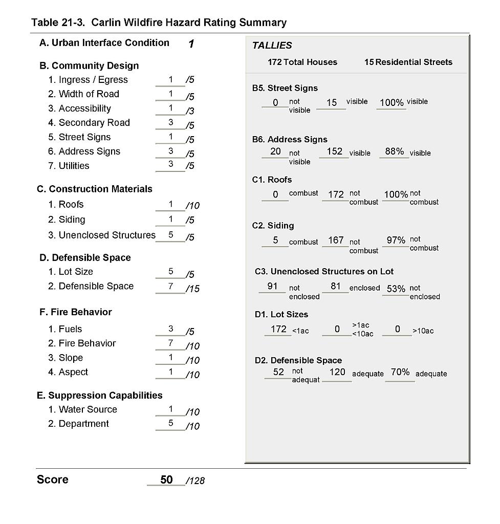 |
Figure 21-1Carlin Fire History, Suppression Resources, and Critical Features |
 |