![]()
![]()
22.0 Currie
22.1 Risk and Hazard Assessment
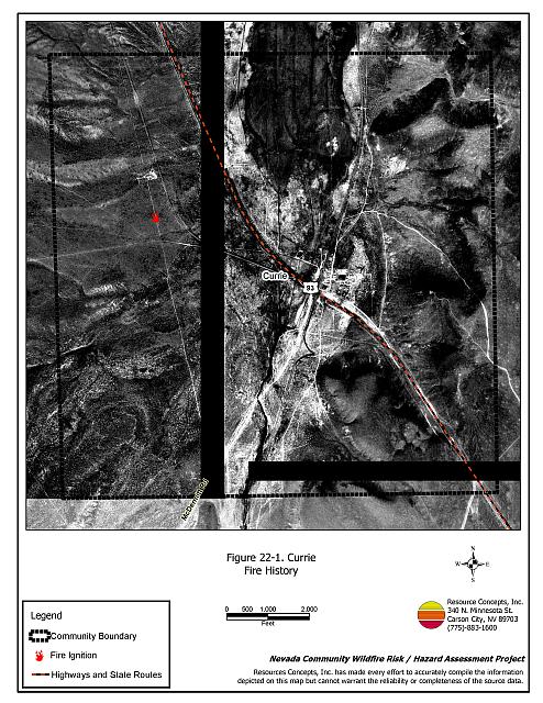
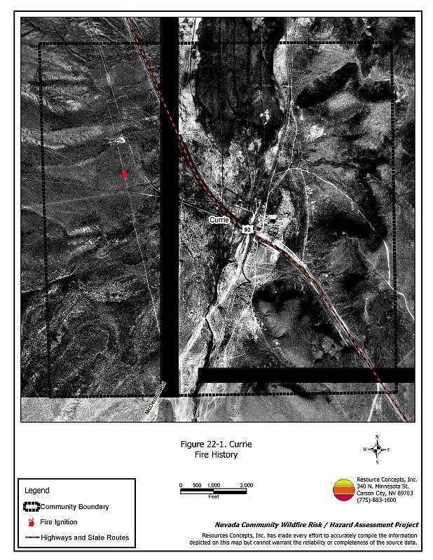
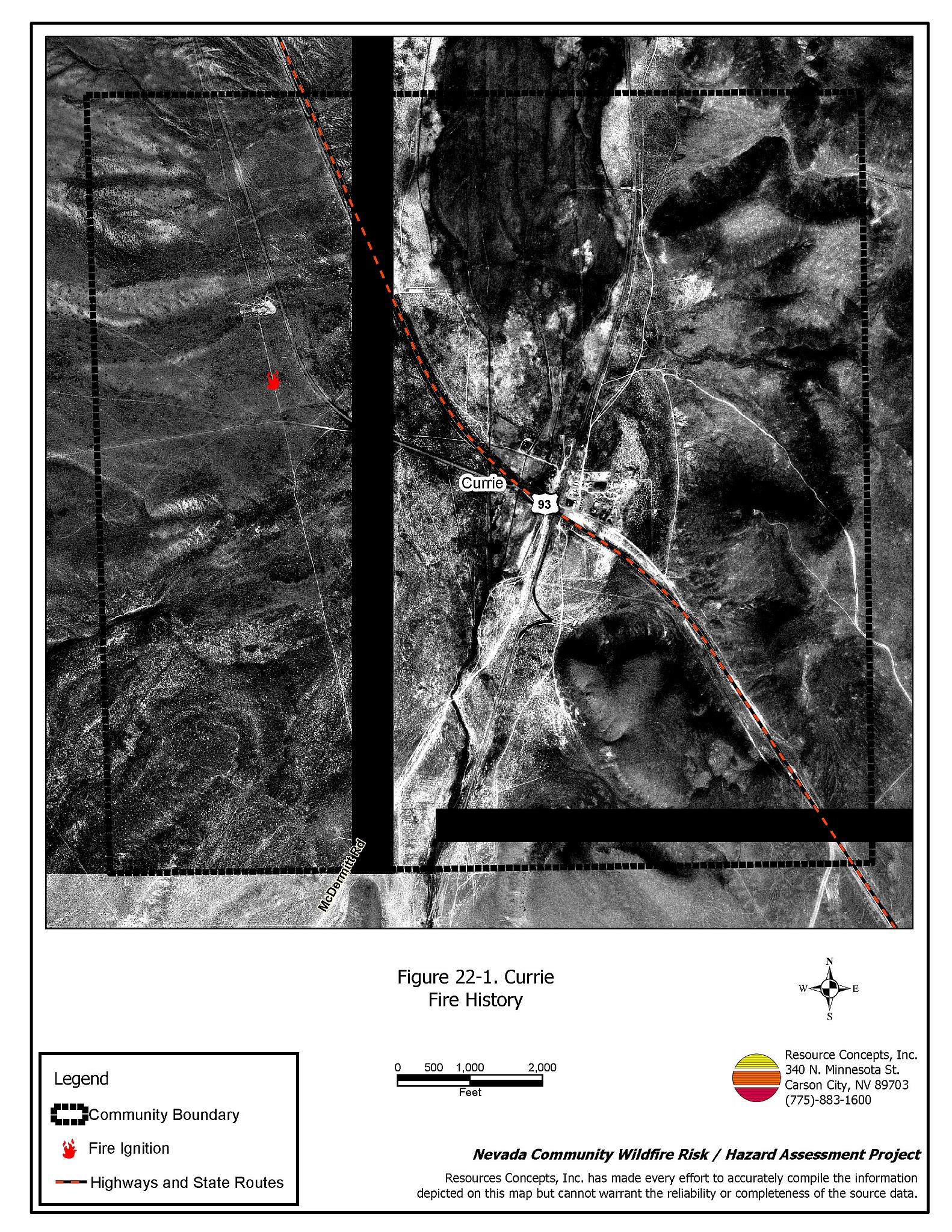
Currie is located in southeast Elko County along Highway 93, between the Cherry Creek Range and Dolly Varden Mountains. Currie is situated at approximately 5,800 feet in elevation. The community hazard assessment resulted in classifying Currie in the Moderate Hazard category (50 points). A summary of the factors that contribute to this hazard rating is included in Table 22-3. The primary factors that contribute to the moderate rating are poor access, lack of water for fire suppression, and no local fire department. The community boundary identified for this report is shown in Figure 22-1.
22.1.1 Community Design
The wildland-urban interface surrounding Currie is an intermix condition: structures and wildland fuels are scattered throughout the community, with no clear line of demarcation separating structures and wildland fuels. Four homes were included in the assessment; all of the homes are on parcels less than one acre in size.
- Access: US Highway 93 is the primary transportation route through Currie. The highway is at least 24 feet wide, paved, and has adequate turnaround space for fire suppression equipment.
- Signage: Street signs and residential addresses were not heavily weighted in the assessment for the four homes located along the highway in Currie. While clear and visible street signs and residential addresses are important in locating homes during low visibility conditions that occur during a wildfire, it is unlikely that fire protection personnel would be unable to rapidly locate any home in the community threatened by wildfire.
- Utilities: All of the utilities are above ground. Power line corridors need proper maintenance to minimize wildfire damage to electric utilities and reduce the possibility that sparks could start a fire in adjacent vegetation.
22.1.2 Construction Materials
All of the homes observed in the interface area are built with non-combustible or highly fire resistant siding materials such as medium density fiberboard and fire resistant roofing materials made of composition materials, metal, or tile. Half of the homes have unenclosed porches, decks, or balconies that can create drafts and provide areas where sparks and embers can lodge, smolder, ignite, and rapidly spread fire to the house.
22.1.3 Defensible Space
One of the homes observed in the interface does not meet the minimum defensible space requirement recommended to help protect the home from damage or loss during a wildfire.
22.1.4 Suppression Capabilities
Wildfire Protection Resources
There is no organized fire department in Currie. The closest suppression resources are at the Cherry Creek Volunteer Fire Department in White Pine County. Table 22-1 lists the types of wildfire resources, cooperating partners and equipment available for initial response to Currie in the event of a reported wildfire. Additional resources are available from local, state, and federal agencies through mutual aid agreements as described in Section 4.1.1.
| Type of Equipment | Amount of Equipment | Cooperating Partner (Resource Location) |
|---|---|---|
| Type 4 Engines SEAT |
1 1 |
Bureau of Land Management (Wells) |
| Type 3 Engine Type 6 Engine Water Tender (2,000 gallon) |
1 1 1 |
Steptoe/Cherry Creek VFD (Cherry Creek) |
| Type 3 Helicopter Air Attack Platform |
1 1 |
Bureau of Land Management (Elko Helibase) |
| Source: Sam Hicks, Nevada Division of Forestry Elko County Prevention Captain; Joe Freeland, Bureau of Land Management Elko Fire Management Officer; Kevin Hall, Nevada Division of Forestry Northern Region FMO; Tom Turk, Nevada Division of Forestry Northern Region Battalion Chief; Melody Asher, US Forest Service Zone FMO; John Evans, Steptoe/Cherry Creek VFD Chief. | ||
Water Sources and Infrastructure
There is no designated water source for fire suppression. Water may be available from local wells, ponds, and streams.
22.1.5 Factors Affecting Fire Behavior
The community lies at the south end of a north-south valley with mountains to the west, east and south. The terrain within the community boundary is generally flat. The prevailing wind direction is from the south and southwest. There is a history of afternoon thunderstorms and dry lightning strikes in the area. The vegetative fuel density in the Currie interface area is generally moderate, estimated at two to three tons per acre and considered a moderate fuel hazard. Fuels in the community consist primarily of basin wildrye, greasewood, rabbitbrush, perennial grasses, halogeton, and other annuals. In the hills east of Currie, the fuel loading of sagebrush and halogeton is less than one ton per acre with a low fuel hazard.
22.1.6 Fire Behavior Worst Case Scenario
The worst-case scenario for a wildfire in the area surrounding Currie would start from a dry lightning storm on a summer day in a year with normal to above normal precipitation and high annual grass and forb production. Erratic winds from thunderstorms could drive the fire into the community from any direction and threaten structures before suppression resources could arrive.
22.1.7 Ignition Risk Assessment
Currie has a high risk of ignition based on fire history in the area and the potential for increased fuel loading from annuals in high precipitation years. There is a moderate wildfire history in the public lands surrounding the community and a history of lightning strikes around the community. The primary risk of ignition in Currie is lightning, although human caused ignitions are unpredictable and can occur at any time.
22.2 Risk and Hazard Reduction Recommendations
The responsibility to keep a community fire safe falls not only on the local fire protection district but also on the residents and local governments. The recommendations for Currie focus primarily on the ongoing and additional efforts to create and maintain defensible space, and on the community coordination and public education efforts that could be undertaken to enhance fire safety.
22.2.1 Defensible Space Treatments
Defensible space treatments are an essential first line of defense for residential structures. The goal of the treatments is to significantly reduce or remove flammable vegetation within a prescribed distance from structures (Refer to Appendix E for the minimum recommended defensible space area). Defensible space reduces the fire intensity and improves firefighter and homeowner chances for successfully defending a structure against an oncoming wildfire.
Property Owners Recommendations
- Remove, reduce, and replace vegetation around homes according to the guidelines in Appendix E. This area should be kept:
- Lean: There are only small amounts of flammable vegetation.
- Clean: There is no accumulation of dead vegetation or other flammable debris.
- Green: Existing plants are healthy and green during the fire season.
- Store firewood a minimum distance of thirty feet from structures.
- Remove all dead vegetation and other flammable materials a minimum of five feet from the exterior of the structure.
- Immediately dispose of cleared vegetation when implementing defensible space treatments. This material dries quickly and poses a fire hazard if left on site.
- Clear all vegetation and combustible materials around propane tanks for a minimum distance of ten feet.
- Mow or remove brush growing against fences in the community. The minimum distance for clearance should be ten feet in grass and 25 feet in brush.
- Maintain the defensible space as needed.
22.2.2 Fuel Reduction Treatments
Fuel reduction treatments are applied on a larger scale than defensible space treatments. Permanently changing the fuel characteristics over large blocks of land to one of a lower volume and one of altered distribution reduces the risk of a catastrophic wildfire in the treated area. Reducing vegetation along roadways and driveways could reduce the likelihood of blocking access and escape routes, help contain the fire perimeter, and improve firefighter access and safety for protecting homes.
Nevada Department of Transportation
- Reduce vegetation and maintain Highway 93 by mowing all vegetation to a height of no more than four inches for a distance of twenty feet from the edge of the road on both sides of the road. Remove and dispose of biomass at an appropriate site. Reseed treated areas with fire resistant species such as recommended in Appendix E to minimize cheatgrass and noxious weed invasion.
Utility Company
- Reduce and remove vegetation to maintain clearance around power lines. Clear vegetation within fifteen feet of utility poles near the community.
22.2.3 Fire Suppression Resources
Nevada Division of Forestry
- Install a minimum capacity 10,000-gallon water tank in the community for fire suppression.
| Involved Party | Recommended Treatment | Recommendation Description |
|---|---|---|
| Property Owners |
Defensible Space | Remove, reduce, and replace vegetation around homes according to the guidelines in Appendix E. Maintain the defensible space as needed. |
| Nevada Department of Transportation | Fuels Reduction | Reduce vegetation and maintain Highway 93 by mowing all vegetation to a height of no more than four inches for a distance of twenty feet from the edge of the road on both sides of the road. |
| Utility Company | Fuels Reduction | Reduce and remove vegetation to maintain clearance around power lines. Clear vegetation within fifteen feet of utility poles near the community. |
| Nevada Division of Forestry | Fire Suppression | Install a minimum capacity 10,000-gallon water tank in the community for fire suppression. |
Table 22-3Currie Wildfire Hazard Rating Summary |
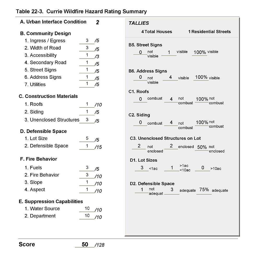 |
Figure 22-1Currie Fire History |
 |