![]()
![]()
23.0 Elburz
23.1 Risk and Hazard Assessment
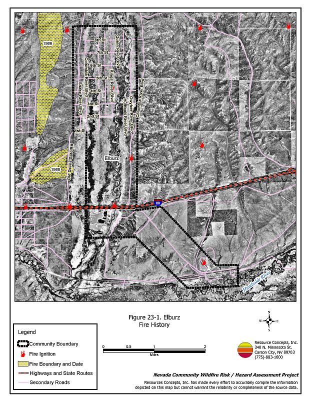
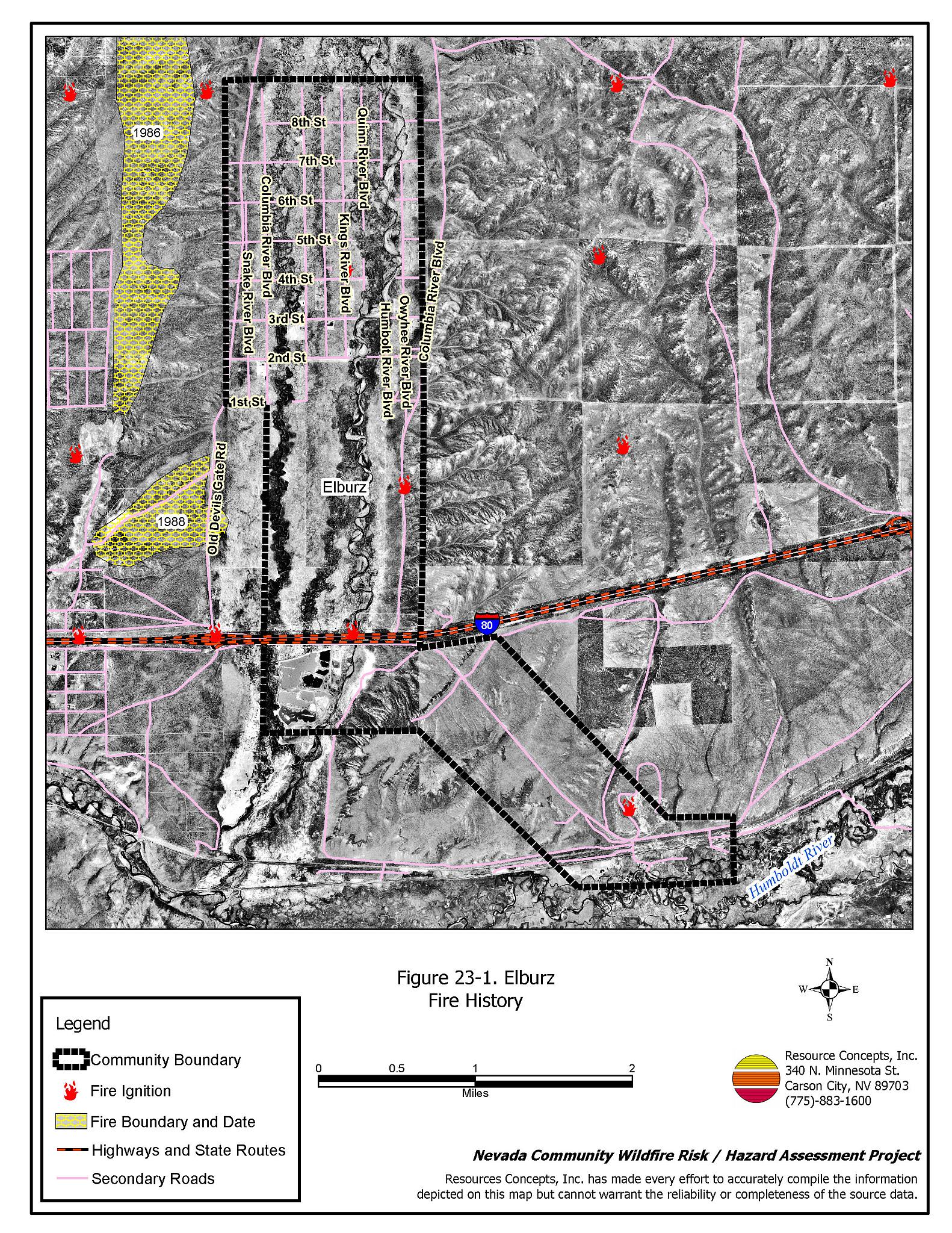
Elburz is located approximately twenty miles east of Elko along Interstate 80 at an elevation of approximately 5,210 feet. The community hazard assessment resulted in classifying Elburz in the Moderate Hazard category (52 points). A summary of the factors that contribute to this hazard rating is included in Table 23-3. The moderate rating is primarily attributed to inadequate street and address signage, lack of fire protection resources, and scant water availability. The community boundary identified for this report is shown in Figure 23-1.
23.1.1 Community Design
The wildland-urban interface surrounding Elburz is an intermix condition: structures and wildland fuels are scattered throughout the community, with no clear line of demarcation separating structures and wildland fuels. Forty homes were included in this assessment. Thirty-eight of those homes are on parcels of one to ten acres in size; the remaining homes are on lots of one acre or less.
- Access: Old Devil’s Gate Road and Columbia River Boulevard are the access routes to Elburz from Interstate 80. The roadways are at least 24 feet wide and have adequate turnaround space for fire suppression equipment to maneuver.
- Signage: Street signs are not visible on any of the streets in Elburz. Only fifteen percent of the residential addresses are visible. Clear and visible street signs and residential addresses are important in locating homes during low visibility conditions that occur during a wildfire.
- Utilities: All of the utilities are above ground. Power line corridors need proper maintenance to minimize wildfire damage to electric utilities and reduce the possibility that sparks could start a fire in adjacent vegetation.
23.1.2 Construction Materials
Ninety percent of the homes observed in the interface area are built with non-combustible or highly fire resistant siding materials such as medium density fiberboard. All of the homes have fire resistant roofing of composition materials, metal, or tile. A third of the homes have unenclosed porches, decks, or balconies that create drafts and provide areas where sparks and embers can lodge, smolder, ignite, and rapidly spread fire to the house.
23.1.3 Defensible Space
Eighty-five percent of the homes observed met the minimum defensible space requirement recommended to help protect the home from damage or loss during a wildfire.
23.1.4 Suppression Capabilities
Wildfire Protection Resources
Fire protection for Elburz is provided by the Ryndon Volunteer Fire Department, which is located six miles west of the community. Table 23-1 lists the types of local wildfire resources and equipment available for initial response to Elburz in the event of a reported wildfire. Additional resources are available from local, state, and federal agencies through mutual aid agreements as described in Section 4.1.1.
| Type of Equipment | Amount of Equipment | Cooperating Partner (Resource Location) |
|---|---|---|
| Type 3 Engine Type 6 Engine |
1 1 |
Ryndon VFD (Ryndon) |
| Type 4 Engine | 1 | Bureau of Land Management (Elko) |
| Type 3 Engine Type 1 Water Tender |
1 1 |
Nevada Division of Forestry (Elko) |
| Type 2 Engine | 1 | Lee Engine Company (Elko) |
| Source: Sam Hicks, Nevada Division of Forestry Elko County Prevention Captain; Bill Krohn, Ryndon VFD Chief | ||
Water Sources and Infrastructure
There are water resources designated for fire suppression in Elburz. While there are some private wells in the area, reliable water sources are generally farther than 45 minutes away, round trip. Though the Humboldt River is nearby, the flow can be very low in this reach of the river during the summer months.
23.1.5 Factors Affecting Fire Behavior
The vegetative fuel density in the Elburz interface area is generally light, estimated at one to two tons per acre and considered a moderate fuel hazard. Fuels in the community and interface area consist primarily of big sagebrush, rabbitbrush, greasewood, cheatgrass, squirreltail, and basin wildrye. Cheatgrass growth is dependent on annual moisture and will produce increased fuel volumes and elevated fuel hazard conditions in years of higher than average precipitation. The terrain within the community boundary is mostly flat. The prevailing wind direction is from the south and southwest. There is a history of afternoon summer thunderstorms and dry lightning strikes in the area.
23.1.6 Fire Behavior Worst Case Scenario
The worst-case scenario for a wildfire in the area surrounding Elburz would start south of Elburz and north of I-80 with strong winds, greater than twenty miles per hour, from the south/southwest. Mobile homes in the area could be quickly threatened before suppression resources could arrive.
23.1.7 Ignition Risk Assessment
Elburz has a moderate risk of ignition based on fire history in the area and the potential for increased fuel loading from annual grasses in high precipitation years. There is a history of lightning strikes around the community. The primary risks of ignition in Elburz are lightning, auto accidents on I-80 that could spark nearby vegetation, railroad sparks, and other human caused ignitions that can occur at any time.
23.2 Risk and Hazard Reduction Recommendations
The responsibility to keep a community fire safe falls not only on the local fire protection district but also on the residents and local governments. The recommendations for the Elburz area focus primarily on the ongoing and on additional efforts to create and maintain defensible space and on the community coordination and public education efforts that could be undertaken to enhance fire safety.
23.2.1 Defensible Space Treatments
Defensible space treatments are an essential first line of defense for residential structures. The goal of the treatments is to significantly reduce or remove flammable vegetation within a prescribed distance from structures. (Refer to Appendix E for the minimum recommended defensible space area). Defensible space reduces the fire intensity and improves firefighter and homeowner chances for successfully defending a structure against an oncoming wildfire.
Property Owners Recommendations
- Remove, reduce, and replace vegetation around homes according to the guidelines in Appendix E. This area should be kept:
- Lean: There are only small amounts of flammable vegetation.
- Clean: There is no accumulation of dead vegetation or other flammable debris.
- Green: Existing plants are healthy and green during the fire season.
- Store firewood a minimum distance of thirty feet from structures.
- Remove all dead vegetation and other flammable materials a minimum of five feet from the exterior of the structure.
- Mow or remove brush growing against fences in the community. The minimum distance for clearance should be ten feet in grass and 25 feet in brush.
- Maintain areas under wood decks and porches free of weeds and other flammable debris. Enclose these areas when possible. Box in eves and cover attic and other ventilation openings with very fine metal wire mesh to prevent embers from entering the attic or crawl space.
- Where cheatgrass has become dominant within the defensible space zone, areas should be mowed prior to seed maturity or treated with an application of a pre-emergent herbicide. Treatments may need to be repeated for several years to ensure that the seed bank of unwanted annual grass seeds has been depleted. Refer to Appendix E for a recommended seed mixture and planting guidelines that can be used in conjunction with cheatgrass removal.
- Clear all vegetation and combustible materials around propane tanks for a minimum distance of ten feet.
- Mow grass within the defensible space zone to maintain a maximum height of four inches.
- Prune all tree branches to a minimum distance of fifteen feet from buildings, paying special attention to areas around chimneys.
- Install spark arrestors on chimneys.
- Board up or remove abandoned trailers and other structures to prevent ignition from sparks or firebrands.
23.2.2 Fuel Reduction Treatments
Fuel reduction treatments are applied on a larger scale than defensible space treatments. Permanently changing the fuel characteristics over large blocks of land to one of a lower volume and one of altered distribution reduces the risk of a catastrophic wildfire in the treated area. Reducing vegetation along roadways and driveways could reduce the likelihood of blocking access and escape routes, help contain the fire perimeter, and improve firefighter access and safety for protecting homes.
Union Pacific Railroad
- Mow or reduce vegetation within a minimum distance of twenty feet on both sides of the railroad tracks. Reseed according to the recommendations in Appendix E if necessary to prevent cheatgrass or other noxious weed invasion. Maintain low growing, low-density fuel volumes within the railroad corridors to reduce the wildfire ignition risk and hazard.
Elko County and Nevada Department of Transportation
- Reduce vegetation and maintain roads by mowing all vegetation to a height of no more than four inches for a distance of twenty feet from the edge of the road on both sides of the road. Remove biomass and disposed of it at an appropriate site. Reseed treated areas with fire resistant species such as recommended in Appendix E to minimize cheatgrass and noxious weed invasion.
Utility Company
- Reduce and remove vegetation to maintain clearance around power lines. Clear vegetation within fifteen feet of utility poles near the community. Remove all trees from beneath power lines.
23.2.3 Fire Suppression Resources
Nevada Division of Forestry
- Install a minimum capacity 10,000-gallon water tank in the north Elburz area for fire suppression.
23.2.4 Community Coordination
Nevada Division of Forestry
- Work with the residents to develop and enforce a brush clearance and biomass disposal program to include cleaning weeds and debris from around structures and fences in the community.
Elko County
- Promote cooperation between the Assessor’s Office and the Roads Department to ensure that all new development roads are named, mapped, signed, and identified with GPS locations.
- Continue to require all future development in the County to meet the National Fire Codes with regard to community design, building construction and spacing, road construction and design, water supply and emergency access. Refer to Appendix F for an example of fire safe recommendations for planning new developments.
Property Owners
- Ensure residential addresses are easily visible from the road. The best place to post an address is where the driveway meets the road. Address characters should be at least four inches tall and reflective on a dark background. Improving the visibility of addresses will facilitate the navigation of unfamiliar neighborhoods for rescue and suppression.
- Coordinate through the ROWE Group (Ryndon, Osino, White Rock, Elburz) to form a local community-based organization to take responsibility and provide leadership for community-wide fuels reduction and community fire safety. The Nevada Fire Safe Council is one option for community organization. Through the establishment of a local Nevada Fire Safe Council Chapter, local communities will become part of a large network for sharing information, including notification of programs and funding opportunities for fire mitigation projects such as those listed in this report. The Nevada Fire Safe Council will accept and manage grants and contracts on the Chapter’s behalf through its non-profit status. The Nevada Fire Safe Council will provide assistance and support to communities to complete fire safe plans, set priorities, educate and train community members, and promote success stories of its members. To form a local chapter or for more information contact the:
Nevada Fire Safe Council
210 South Roop Street Suite 101
Carson City, NV 89701
www.nvfsc.org
23.2.5 Public Education
A public education program that explains fire safe measures in clear and emphatic terms will have an impact on residents of the wildland-urban interface. Informed community members will be more inclined to make efforts to effectively reduce wildfire hazards around their homes and neighborhoods.
Nevada Division of Forestry
- Distribute copies of the publication “Living With Fire”. This publication is free of charge. Copies can be requested from the University of Nevada Cooperative Extension.
23.3 Summary of Recommendations
| Involved Party | Recommended Treatment | Recommendation Description |
|---|---|---|
| Property Owners |
Defensible Space | Remove, reduce, and replace vegetation around homes according to the guidelines in Appendix E. Maintain the defensible space as needed. |
| Community Coordination | Coordinate through the ROWE Group to form a local community-based organization to provide leadership and be responsible for community-wide fuel reduction treatments and community fire safety. | |
| Elko County Nevada Department of Transportation |
Fuels Reduction | Reduce vegetation and maintain roads by mowing all vegetation to a height of no more than four inches for a distance of twenty feet from the edge of the road on both sides of the road. |
| Utility Company | Fuels Reduction | Reduce and remove vegetation to maintain clearance around power lines. Clear vegetation within fifteen feet of utility poles near the community. Remove all trees from beneath power lines. |
| Union Pacific Railroad | Fuels Reduction | Mow or reduce vegetation within a minimum distance of twenty feet on both sides of the railroad tracks. |
| Elko County | Community Coordination | Promote cooperation between the Assessor’s Office and the Roads Department to ensure that all new development roads are named, mapped, signed, and identified with GPS locations. Continue to require all future development in the County to meet the National Fire Codes with regard to community design, building construction and spacing, road construction and design, water supply and emergency access. Refer to Appendix F for an example of fire safe recommendations for planning new developments. |
| Nevada Division of Forestry | Community Coordination | Develop and enforce a brush clearance and biomass disposal program to include cleaning weeds and debris from around structures and fences in the community. |
| Fire Suppression Resources | Install a minimum capacity 10,000-gallon water tank in the community for fire suppression. | |
| Public Education | Obtain copies of the publication “Living With Fire”. This publication is free of charge. |
Table 23-3Elburz Wildfire Hazard Rating Summary |
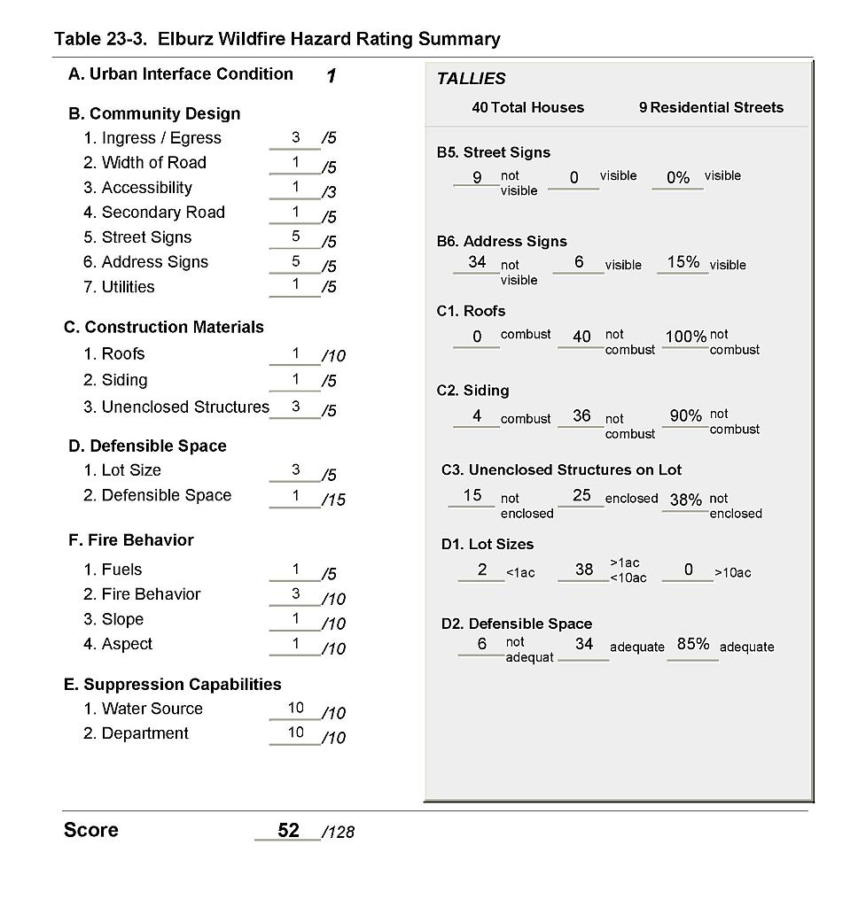 |
Figure 23-1Elburz Fire History |
 |