![]()
![]()
24.0 Elko
24.1 Risk and Hazard Assessment
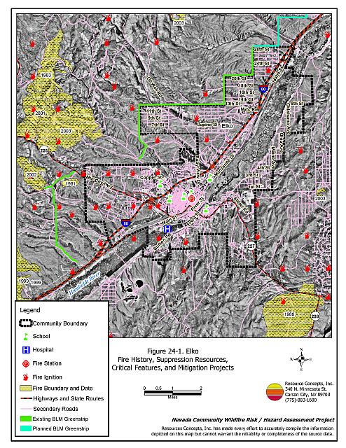
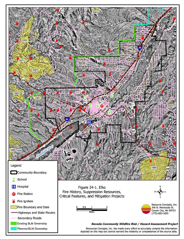
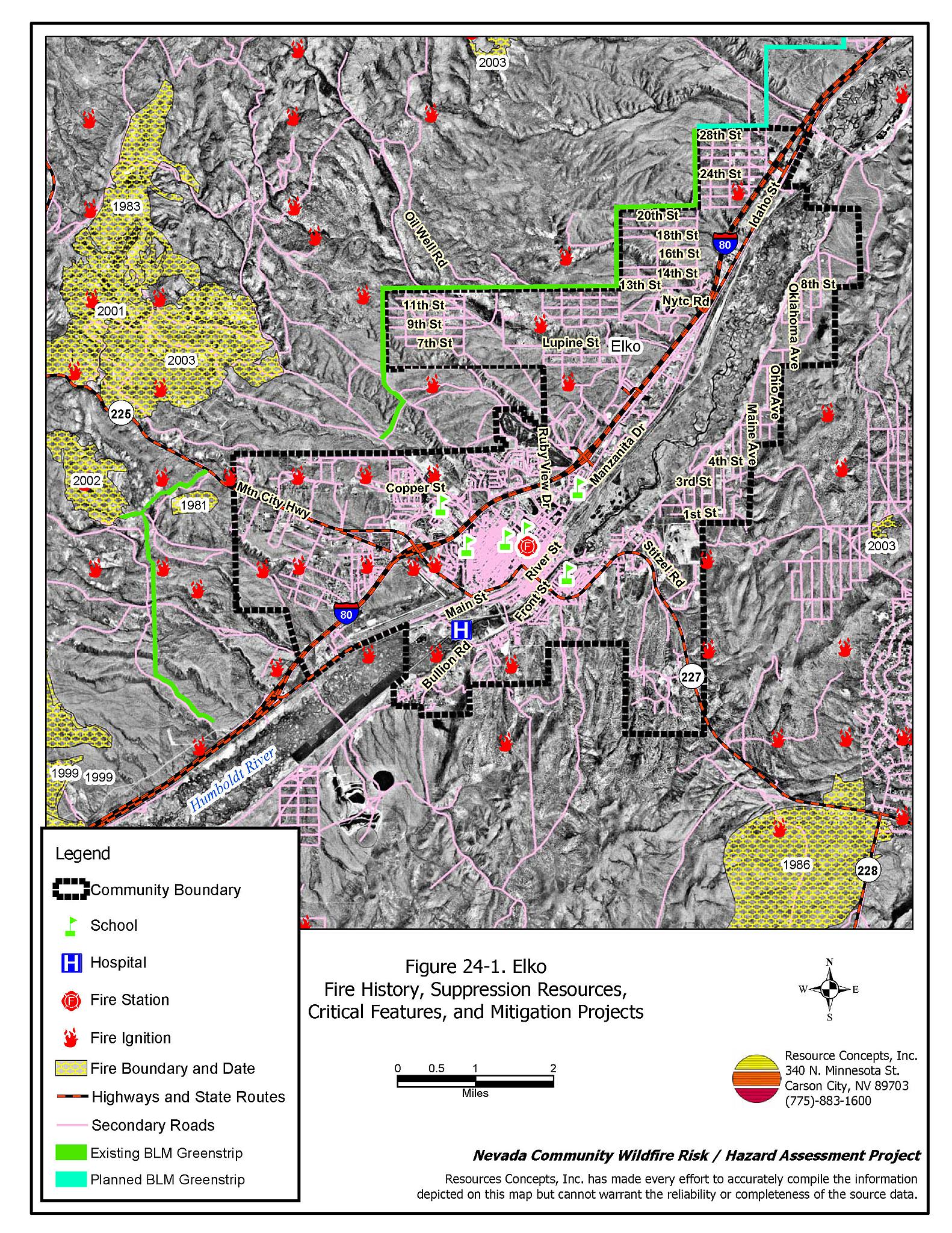
The city of Elko is the County seat of Elko County with a population of approximately 18,400 people. It is located on Interstate 80 at an elevation of approximately 4,500 feet. The Humboldt River runs through the town. The community hazard assessment resulted in classifying Elko in the Moderate Hazard category (58 points). A summary of the factors that contribute to this hazard rating is included in Table 24-3. The rating is primarily attributed to inadequate defensible space and potentially erratic fire behavior and high fire intensity that could result in difficult fire control conditions. The community boundary identified for this report is shown in Figure 24-1.
24.1.1 Community Design
The Elko wildland-urban interface has a mix of classic and intermix interface conditions. In most of the community, clear boundary between structures and wildland fuels exists. In other areas structures and wildland fuels are scattered throughout the community, with no clear separation between structures and wildland fuels. A total of 973 homes were included in the assessment: 720 on lots of one acre or less in size, 249 on parcels of one to ten acres; and four on parcels of over ten acres in size.
- Access: Interstate 80 is the major transportation route through Elko. The highway is at least 24 feet wide, paved, and has adequate turnaround space for fire suppression equipment. Some of the rural roads are narrow, steep, and in poor condition. This is especially true for the northwest side of town.
- Signage: Ninety-two percent of the streets have clearly posted signs and approximately two-thirds of the homes have clearly visible addresses. Clear and visible street signs and residential addresses are important in locating homes during low visibility conditions that occur during a wildfire.
- Utilities: Utilities are both above and below ground. Power line corridors need proper maintenance to minimize wildfire damage to electric utilities and reduce the possibility that sparks could start a fire in adjacent vegetation.
24.1.2 Construction Materials
Ninety-six percent of the homes observed in the interface area are built with non-combustible or highly fire resistant siding materials such as medium density fiberboard. Ninety-nine percent of the homes have fire resistant roofing made of composition materials, metal, or tile. One-third of the homes have unenclosed porches, decks, or balconies that create drafts and provide areas where sparks and embers can lodge, smolder, ignite, and rapidly spread fire to the house.
24.1.3 Defensible Space
Only two-thirds of the homes observed in the interface meet the minimum defensible space requirement recommended to help protect the home from damage or loss during a wildfire.
24.1.4 Suppression Capabilities
Wildfire Protection Resources
The Elko Fire Department consists of the career department staffed by seventeen career firefighters and the Lee Company volunteers with 35 volunteer firefighters. Table 24-1 lists the types of local wildfire resources, cooperating partners, and equipment available for initial response to Elko in the event of a reported wildfire. Additional resources are available from local, state, and federal agencies through mutual aid agreements as described in Section 4.1.1.
| Type of Equipment | Amount of Equipment | Cooperating Partner (Resource Location) |
|---|---|---|
| Type 1 Engine Type 3 Engine Type 4 Engine Type 5 Engine Water Tender |
4 3 1 2 1 |
Elko Fire Department/Lee Company (Elko) |
| Type 4 Engine | 1 | Bureau of Land Management (Elko) |
| Type 3 Engine Type 1 Water Tender |
1 1 |
Nevada Division of Forestry (Elko) |
| Source: Sam Hicks, Nevada Division of Forestry Elko County Prevention Captain; Alan Kightlinger, Elko Fire Department Chief | ||
Water Sources and Infrastructure
Water resources available to the community for fire suppression include hydrants within 500 feet of structures with minimum flows of 500 gpm. There are nine storage tanks in the area with a total capacity of 23 million gallons. The water system is powered by gravity and electric pumps. There are emergency generators for the water system in the event of a power outage.
Fire Protection Personnel Qualifications
All Elko Fire Department and Lee Company firefighters have a minimum of State Fire Marshal Entry Level firefighting training and Nevada Division of Forestry Basic Wildland Firefighting training.
Work Load
The Elko Fire Department responded to approximately 1500 calls in 2003:
- 980 emergency medical calls.
- 30 wildland/brush fire calls.
- Over 400 other calls.
Financial Support
Funding for the Elko Fire Department is provided through the City of Elko Emergency Funds, the Elko County General Fund, and through agreements with the Nevada Division of Forestry and the Bureau of Land Management.
Community Preparedness
Elko County has an active Local Emergency Planning Committee and has adopted an emergency plan that includes a hazardous materials response plan and an all-risk disaster response plan, which is updated annually. The City of Elko maintains an Emergency Plan, a Pre-attack Plan, and an emergency evacuation plan. The Elko Fire Department reviews development plans and has an enforced brush clearance program. The Elko Fire Department strictly enforces the fire code and the city ordinance for minimum clearance around structures.
24.1.5 Factors Affecting Fire Behavior
The vegetative fuel density in the Elko interface area is generally moderate, estimated at two to three tons per acre. The fuel hazard is moderate. Fuels consist primarily of two to four feet tall sagebrush and rabbitbrush, with an understory of cheatgrass, squirreltail, crested wheatgrass, basin wildrye, and other annuals. In the southeast area of the community pinyon and juniper trees increase the fuel loading to five to eight tons per acre, resulting in a high fuel hazard. The terrain within the community boundary is gently rolling with slopes of eight to twenty percent. The prevailing wind direction is from the south and southwest. There is a history of summer afternoon thunderstorms and dry lightning strikes in the area.
The Bureau of Land Management Elko Field Office has been actively planning and implementing fuels reduction treatments near Elko and along Interstate 80 between Elko and the Osino area. Phases I and II of the Elko North greenstrip have been completed in 2004 and 2005 respectively. The greenstrips were constructed using mechanical mastication equipment to remove sagebrush fuels. Approximately 387 acres were treated. A third phase of the greenstrip is planned for construction on the north side of Interstate 80 from Elko to the northwest boundary of Osino. The greenstrip will be 300 feet wide for a total treatment area of approximately 285 acres.
24.1.6 Fire Behavior Worst Case Scenario
The worst-case scenario for a wildfire in the area surrounding Elko would start southwest of town in a year with high cheatgrass production. A strong southwest wind would drive the fire towards town, fueled by annual grasses. The fire could spot across the firebreak and spread through the brush, threatening homes in the community.
24.1.7 Ignition Risk Assessment
Elko has a moderate ignition risk based on fire history in the area and the potential for increased fuel loading from annuals in high precipitation years. The primary risk of ignition in Elko is lightning, although human caused ignitions are unpredictable and can occur at any time.
24.1.8 Completed Fuels Reduction Treatments
The Bureau of Land Management Elko Field Office has been actively planning and implementing fuels reduction treatments near Elko and along Interstate 80 between Elko and the Osino/Ryndon area. Phases I and II of the Elko North greenstrip were completed in 2004 and 2005 respectively. The City of Elko also maintains a 75 to 150 foot wide firebreak around portions of the city.
24.2 Risk and Hazard Reduction Recommendations
The responsibility to keep a community fire safe falls not only on the local fire protection district but also on the residents, businesses, and local governments. The recommendations for the Elko area focus primarily on the ongoing and additional efforts to create and maintain defensible space and on the future requirements that new developments will be planned and constructed to create fire safe communities. Other recommendations pertain to community coordination and public education efforts that could be undertaken to enhance fire safety.
24.2.1 Defensible Space Treatments
Defensible space treatments are an essential first line of defense for residential structures. The goal of the treatments is to significantly reduce or remove flammable vegetation within a prescribed distance from structures. (Refer to Appendix E for the recommended defensible space area). Defensible space reduces the fire intensity and improves firefighter and homeowner chances for successfully defending a structure against an oncoming wildfire.
Property Owners Recommendations
- Remove, reduce, and replace vegetation around homes according to the guidelines in Appendix E. This area should be kept:
- Lean: There are only small amounts of flammable vegetation.
- Clean: There is no accumulation of dead vegetation or other flammable debris.
- Green: Existing plants are healthy and green during the fire season.
- Store firewood a minimum distance of thirty feet from structures.
- Remove all dead vegetation and other flammable materials a minimum of five feet from the exterior of the structure.
- Mow or remove brush growing against fences in the community. The minimum distance for clearance should be ten feet in grass and 25 feet in brush.
- Maintain areas under wood decks and porches free of weeds and other flammable debris. Enclose these areas when possible. Box in eves and cover attic and other ventilation openings with very fine metal wire mesh to prevent embers from entering the attic or crawl space.
- Clear all vegetation and combustible materials around propane tanks for a minimum distance of ten feet.
- Where cheatgrass has become dominant within the defensible space zone, areas should be mowed prior to seed maturity or treated with an application of a pre-emergent herbicide. Treatments may need to be repeated for several years to ensure that the seed bank of unwanted annual grass seeds has been depleted. Refer to Appendix E for a recommended seed mixture and planting guidelines that can be used in conjunction with cheatgrass removal.
- Immediately dispose of cleared vegetation when implementing defensible space treatments. This material dries quickly and poses a fire hazard if left on site.
- Clear weeds and brush to a width of ten feet along both sides of the driveways.
- Install spark arrestors on chimneys.
- Board up or remove abandoned trailers and other structures to prevent ignition from sparks or firebrands.
- Mow grass within the defensible space zone to maintain a maximum height of four inches.
- Where possible, irrigate all trees and large shrubs that remain in close proximity to structures to increase their fire resiliency. This is especially important during drought conditions.
- Prune all tree branches to a minimum distance of fifteen feet from buildings, paying special attention to areas around chimneys.
24.2.2 Fuel Reduction Treatments
Fuel reduction treatments are applied on a larger scale than defensible space treatments. Permanently changing the fuel characteristics over large blocks of land to one of a lower volume and one of altered distribution reduces the risk of a catastrophic wildfire in the treated area. Reducing vegetation along roadways and driveways could reduce the likelihood of blocking access and escape routes, help contain the fire perimeter, and improve firefighter access and safety for protecting homes.
Elko County and Nevada Department of Transportation
- Reduce vegetation and maintain roads by mowing all vegetation to a height of no more than four inches for a distance of twenty feet from the edge of the road on both sides of the road. Remove and dispose of biomass at an appropriate site. Reseed treated areas with fire resistant species such as recommended in Appendix E to minimize cheatgrass and noxious weed invasion.
Utility Company
- Reduce and remove vegetation to maintain clearance around power lines. Clear vegetation within fifteen feet of utility poles near the community. Remove all trees from beneath power lines. Reduce and remove vegetation to maintain a minimum clearance of fifty feet from fences around power substations.
24.2.3 Fire Suppression Resources
Elko Fire Department
- Upgrade the communication system to narrow band technology to assure communication compatibility and include additional repeaters for adequate communication.
- Continue to meet annually with the cooperating agencies to discuss pre-attack plans for the community.
24.2.4 Community Coordination
Elko Fire Department
- Continue to conduct courtesy inspections of defensible space condition and defensible space treatments on private property.
- Coordinate with the appropriate agencies to improve street sign visibility.
Elko County
- Continue to require all future development in the County to meet the National Fire Codes with regard to community design, building construction and spacing, road construction and design, water supply and emergency access. Refer to Appendix F for an example of fire safe recommendations for planning new developments.
Property Owners
- Ensure residential addresses are easily visible from the road. The best place to post an address is where the driveway meets the road. Address characters should be at least four inches tall and reflective on a dark background. Improving the visibility of addresses will facilitate the navigation of unfamiliar neighborhoods for rescue and suppression personnel during a wildfire event.
24.2.5 Public Education
A public education program that explains fire safe measures in clear and emphatic terms will have an impact on residents of the wildland-urban interface. Informed community members will be more inclined to make efforts to effectively reduce wildfire hazards around their homes and neighborhoods.
Elko Fire Department
- Distribute copies of the publication “Living With Fire” to all property owners. This publication is free of charge. Copies can be requested from the University of Nevada Cooperative Extension.
24.3 Summary of Recommendations
| Involved Party | Recommended Treatment | Recommendation Description |
|---|---|---|
| Property Owners |
Defensible Space | Remove, reduce, and replace vegetation around homes according to the guidelines in Appendix E. Maintain the defensible space as needed. |
| Community Coordination | Ensure residential addresses are easily visible from the road. | |
| Utility Company | Fuels Reduction | Reduce and remove vegetation to maintain clearance around power lines. Clear vegetation within fifteen feet of utility poles near the community. Remove all trees from beneath power lines. Reduce and remove vegetation to maintain a minimum clearance of fifty feet from fences around power substations. |
| Elko County Nevada Department of Transportation |
Fuels Reduction | Reduce vegetation and maintain roads by mowing all vegetation to a height of no more than four inches for a distance of twenty feet from the edge of the road on both sides of the road. |
| Elko Fire Department | Fire Suppression Resources | Upgrade the communication system to narrow band technology for communication compatibility. Continue to meet annually with the cooperating agencies to review their pre-attack plans for the community. |
| Community Coordination | Continue to conduct courtesy inspections of defensible space condition and defensible space treatments on private property. Coordinate with the appropriate agencies to improve street sign visibility. |
|
| Public Education | Distribute copies of the publication “Living With Fire” to all property owners. This publication is free of charge. Copies can be requested from the University of Nevada Cooperative Extension. | |
| Elko County | Community Coordination | Continue to require all future development in the County to meet the National Fire Codes with regard to community design, building construction and spacing, road construction and design, water supply and emergency access. Refer to Appendix F for an example of fire safe recommendations for planning new developments. |
Table 24-3Elko Wildfire Hazard Rating Summary |
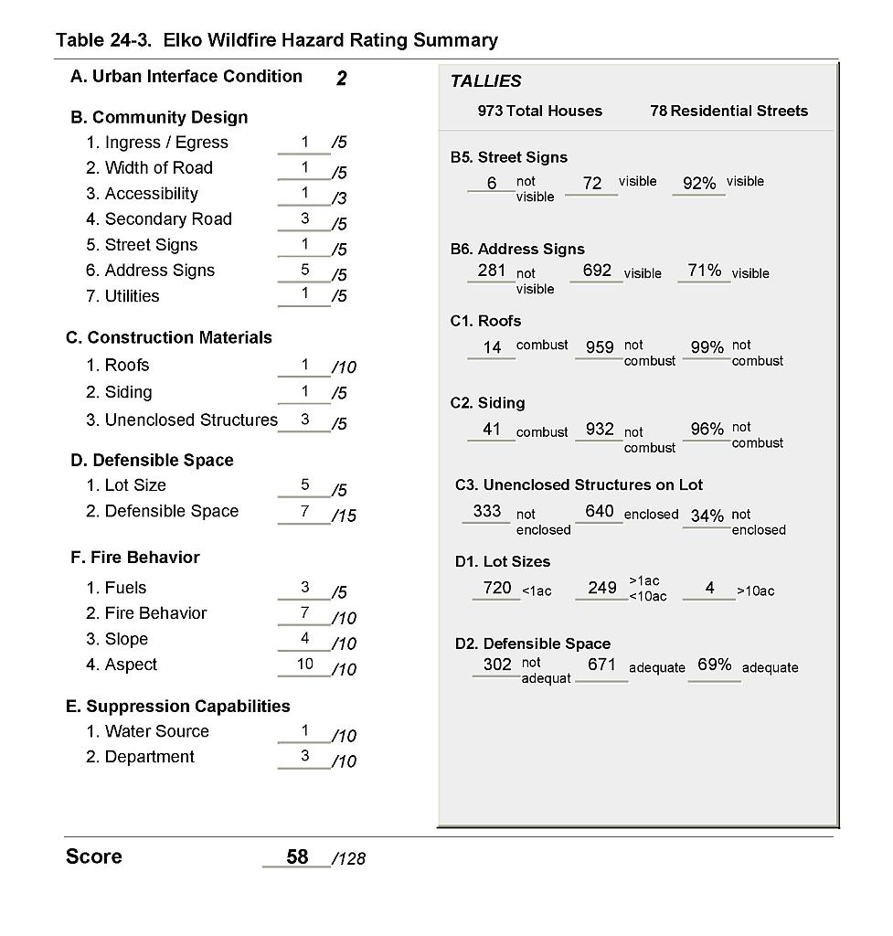 |
Figure 24-1Elko Fire History, Suppression Resources, Critical Features, and Mitigation Projects |
 |