![]()
![]()
25.0 Gold Creek
25.1 Risk and Hazard Assessment
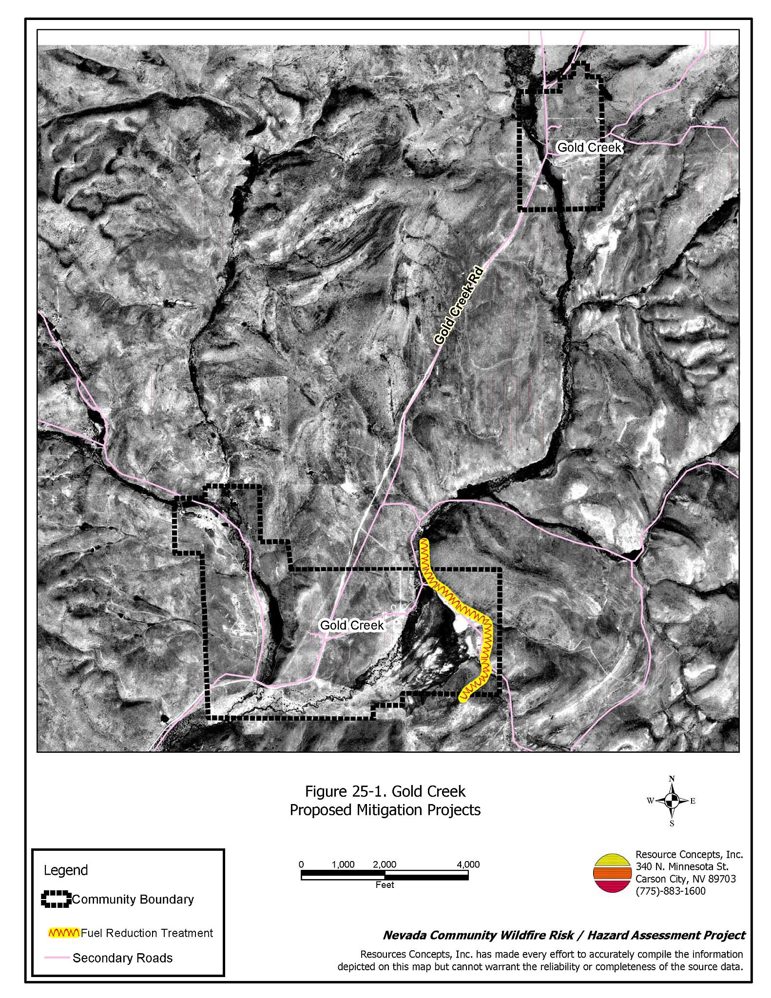
Gold Creek is a former mining town located in northern Elko County on Forest Service Road 037. Gold Creek is situated near the confluence of Gold Creek and Martin Creek, approximately six miles northeast of Wild Horse Reservoir. The community hazard assessment resulted in classifying Gold Creek in the Moderate Hazard category (50 points). A summary of the factors that contribute to this hazard rating is included in Table 25-3. The moderate rating is primarily attributed to limited access, the potential for hazardous fire behavior, and the lack of an active fire department. The community boundary identified for this report is shown in Figure 25-1.
25.1.1 Community Design
The wildland interface in Gold Creek is an intermix condition: structures and wildland fuels are scattered throughout the community, with no clear separation between wildland fuels and developed properties. The community consists of a few homes, two ranches and a US Forest Service Guard Station. Sixteen homes were included in the assessment. Two of the homes are on parcels less than one acre in size and eleven of the homes are on parcels larger than ten acres.
- Access: Gold Creek Road (County Road 037) is the only access in and out of Gold Creek. This narrow road does not provide adequate access, evacuation room, or turnaround space for fire suppression equipment.
- Signage: Street signs and residential addresses were not heavily weighted in the assessment for the few homes and the Guard Station located in Gold Creek. While clear and visible street signs and residential addresses are important in locating homes during low visibility conditions that occur during a wildfire, it is unlikely that fire protection personnel would be unable to rapidly locate any home or structure in the community threatened by wildfire.
- Utilities: All of the utilities are above ground. Power line corridors need proper maintenance to minimize wildfire damage to electric utilities and reduce the possibility that sparks could start a fire in adjacent vegetation.
25.1.2 Construction Materials
All of the homes observed in the interface area are built with non-combustible or highly fire resistant siding materials such as medium density fiberboard and fire resistant roofing materials such as composition roofing, metal, or tile. None of the homes have unenclosed porches, decks, or balconies that create drafts and provide areas where sparks and embers can lodge, smolder, ignite, and rapidly spread fire to the house.
25.1.3 Defensible Space
All of the homes observed in the interface meet the minimum defensible space requirement recommended to help protect the home from damage or loss during a wildfire.
25.1.4 Suppression Capabilities
Wildfire Protection Resources
There is no organized fire department or suppression resources in Gold Creek. Table 25-1 lists the types of wildfire resources, cooperating partners, and equipment available for initial response to Gold Creek in the event of a reported wildfire. Additional resources are available from local, state, and federal agencies through mutual aid agreements as described in Section 4.1.1.
| Type of Equipment | Amount of Equipment | Cooperating Partner (Resource Location) |
|---|---|---|
| Type 6 Engine | 1 | US Forest Service (Mountain City) |
| Type 2 Engine Type 1 Water Tender |
1 1 |
Nevada Division of Forestry (Elko) |
| Type 4 Engine | 1 | Bureau of Land Management (Elko) |
| Source: Sam Hicks, Nevada Division of Forestry Elko County Prevention Captain; Joe Freeland, Bureau of Land Management Elko Fire Management Officer; Kevin Hall, Nevada Division of Forestry Northern Region FMO; Tom Turk, Nevada Division of Forestry Northern Region Battalion Chief; Melody Asher, US Forest Service Zone FMO. | ||
Water Sources and Infrastructure
Water available for fire suppression resources in Gold Creek is limited to ranch ponds and private wells.
25.1.5 Factors Affecting Fire Behavior
The vegetative fuel density in the Gold Creek interface area is low to medium, varying in different areas of the community. On the west side fuel loading is estimated at less than one ton per acre with a low fuel hazard. Northeast of the meadow area fuel loading is estimated at four to six tons per acre with a high fuel hazard, due to the increase in moisture and moisture-dependent grasses and annuals. Fuels throughout the community consist primarily of sagebrush, rabbitbrush, and bitterbrush in some areas, cheatgrass, basin wildrye, and other annuals. The terrain within the community boundary is gently rolling. The prevailing wind direction is from the south and southwest. There is no history of fires in the immediate area.
25.1.6 Fire Behavior Worst Case Scenario
The worst-case scenario for a wildfire in the area surrounding Gold Creek would come from a dry lightning storm on a late summer afternoon with multiple fire ignitions, during an above normal precipitation year and high annual grass and forb production. Strong erratic winds from thunderstorms could push fires from any direction through the Gold Creek area. With fire suppression resources more than thirty minutes away, a wildfire could exceed initial attack resources and spread rapidly.
25.1.7 Ignition Risk Assessment
Gold Creek has a low to moderate risk of ignition based on fire history in the area. The primary risk of ignition in Gold Creek is lightning, although human caused ignitions are unpredictable and can occur at any time.
25.2 Risk and Hazard Reduction Recommendations
The responsibility to keep a community fire safe falls not only on the local fire protection district but also on the residents and local governments. The recommendations for Gold Creek focus primarily on the ongoing and additional efforts to create and maintain defensible space and on the community coordination and public education efforts that could be undertaken to enhance fire safety.
25.2.1 Defensible Space Treatments
Defensible space treatments are an essential first line of defense for residential structures. The goal of the treatments is to significantly reduce or remove flammable vegetation within a prescribed distance from structures. (Refer to Appendix E for the minimum recommended defensible space area). Defensible space reduces the fire intensity and improves firefighter and homeowner chances for successfully defending a structure against oncoming wildfire.
Property Owners Recommendations
- Remove, reduce, and replace vegetation around homes according to the guidelines in Appendix E. This area should be kept:
- Lean: There are only small amounts of flammable vegetation.
- Clean: There is no accumulation of dead vegetation or other flammable debris.
- Green: Existing plants are healthy and green during the fire season.
- Store firewood a minimum distance of thirty feet from structures.
- Remove all dead vegetation and other flammable materials a minimum of five feet from the exterior of the structure.
- Maintain areas under wood decks and porches free of weeds and other flammable debris. Enclose these areas when possible. Box in eves and cover attic and other ventilation openings with very fine metal wire mesh to prevent embers from entering the attic or crawl space.
- Immediately dispose of cleared vegetation when implementing defensible space treatments. This material dries quickly and poses a fire hazard if left on site.
- Clear all vegetation and combustible materials around propane tanks for a minimum distance of ten feet.
- Maintain the defensible space as needed.
- Install spark arrestors on chimneys.
25.2.2 Fuel Reduction Treatments
Fuel reduction treatments are applied on a larger scale than defensible space treatments. Permanently changing the fuel characteristics over large blocks of land to one of a lower volume and one of altered distribution reduces the risk of a catastrophic wildfire in the treated area. Reducing vegetation along roadways and driveways could reduce the likelihood of blocking access and escape routes, help contain the fire perimeter, and improve firefighter access and safety for protecting homes.
Property Owners
- Construct a 200-foot wide fuel reduction treatment in the big sagebrush fuel type on the southern aspects of Little Island Mountain around ranch structures. The brush should be masticated a minimum distance of 200 feet wide around structures.
Forest Service and Elko County
- Reduce vegetation and maintain Gold Creek Road (Forest Service 037) by mowing all vegetation to a height of no more than four inches for a distance of twenty feet from the edge of both sides of the road. Remove and disposed of biomass at an appropriate site. Reseed treated areas with fire resistant species such as recommended in Appendix E to minimize cheatgrass and noxious weed invasion.
25.2.3 Fire Suppression Resources
US Forest Service
- Station a Type 6 Engine and fire crew at the Gold Creek Guard Station during the fire season for seven-day coverage.
25.3 Summary of Recommendations
| Involved Party | Recommended Treatment | Recommendation Description |
|---|---|---|
| Property Owners |
Defensible Space | Remove, reduce, and replace vegetation around homes according to the guidelines in Appendix E. Maintain the defensible space condition annually. |
| Fuels Reduction | Construct a 200-foot wide fuel reduction treatment in the big sagebrush fuel type on the southern aspects of Little Island Mountain around ranch structures. The brush should be masticated a minimum distance of 200 feet wide around structures. | |
| US Forest Service Elko County |
Fuels Reduction | Reduce vegetation and maintain Gold Creek Road by mowing all vegetation to a height of no more than four inches for a distance of twenty feet from the edge of both sides of the road. |
| US Forest Service | Fire Suppression Resources | Station a Type 6 Engine and fire crew at the Gold Creek Guard Station during the fire season. |
Table 25-3Gold Creek Wildfire Hazard Rating Summary |
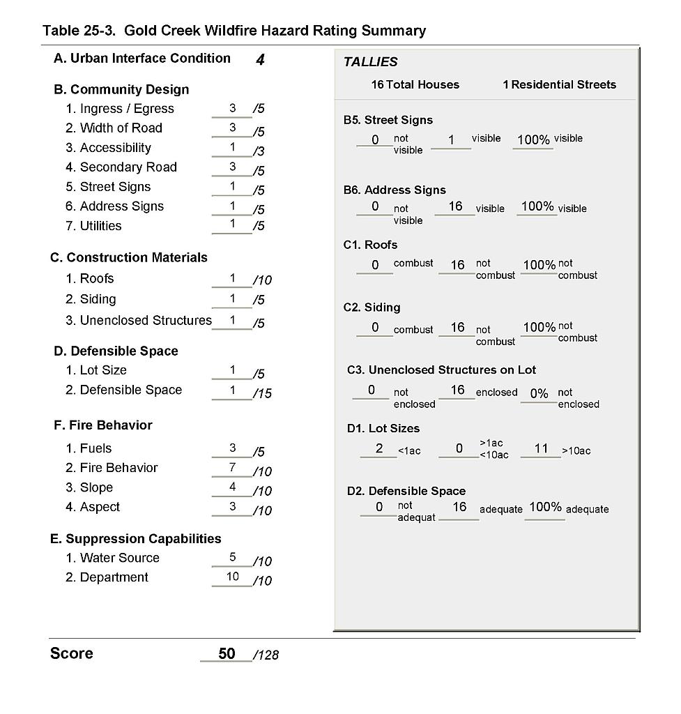 |
Figure 25-1Gold Creek Proposed Mitigation Projects |
 |