![]()
![]()
5.0 Denio
5.1 Risk and Hazard Assessment
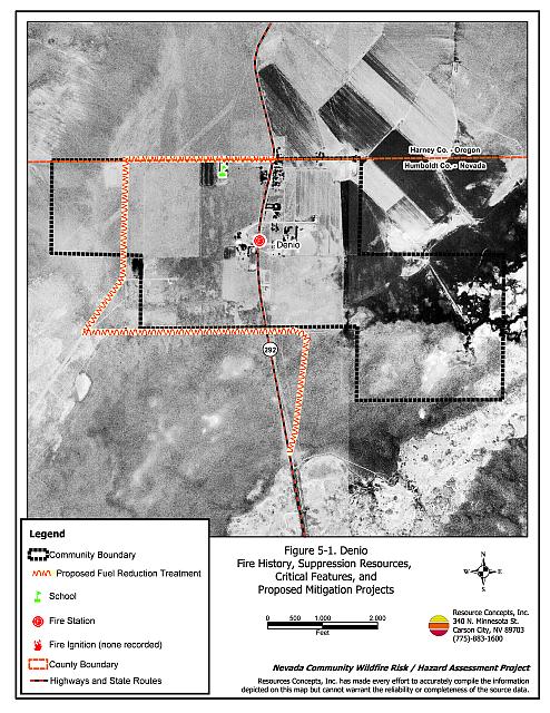
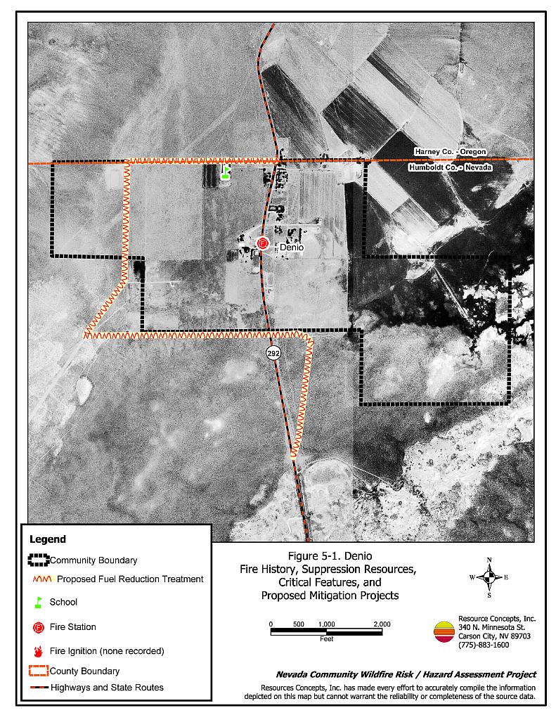
Denio is located in northwest Humboldt County on the Nevada-Oregon border. Denio is accessed via State Route 292, off of State Route 140. The town lies in a valley with steep mountains to the west, and has a large agricultural component. The community hazard assessment resulted in classifying Denio in the Moderate Hazard category (52 points). The moderate rating is attributed to good community design and fire resistant building materials, but the community has limited fire protection resources and limited water available for fire suppression. A summary of the community hazard rating is included in Table 5-3.
5.1.1 Community Design
The area surrounding Denio is classified as an intermix urban interface condition. The RCI Project Team observed a total of 27 homes in the community with no clear line of demarcation between structures and wildland fuels. Nearly all of the homes observed (21) were on parcels between one and ten acres in size; the remaining ones were on lots of one acre or less in size.
- Roads: State Route 292 is the major transportation route through Denio. The highway is at least 24 feet wide, paved, and has adequate turnaround space for fire suppression equipment.
- Signage: Denio is a small community and all of the homes are located along the highway. All of the homes are easily visible from the single access road into the community. There would be little chance of fire suppression personnel being unable to locate a particular structure that needed protection even under the low visibility conditions that may occur during a wildfire.
- Utilities: Electric utilities are all above ground. Power line corridors need proper maintenance to minimize potential ignition risks.
5.1.2 Construction Materials
All but one of the homes observed in the interface area were built with non-combustible or fire-resistant siding materials. All but three of the homes had fire resistant roofing materials such as composition, metal, or tile. None of the homes had unenclosed porches, decks, or balconies that can create drafts and provide areas where firebrands and embers can accumulate, smolder, and ignite, rapidly spreading fire to the house.
5.1.3 Defensible Space
Of the 27 homes observed in the interface, eight did not meet the minimum recommendations for defensible space to help protect the home and minimize damage or loss during a wildfire. Refer to Appendix E or the “Living With Fire” publication for defensible space specifications.
5.1.4 Suppression Capabilities
Wildfire Protection Resources
The Denio Volunteer Fire Department, part of the Pueblo Fire Protection District, provides fire suppression services for Denio. At the time the interviews were conducted for this report, the Denio VFD consisted of eighteen volunteers. Table 5-1 lists wildfire suppression resources available for initial attack to a wildland fire call in Denio. The Denio VFD Fire Station is too small to house all of their fire apparatus. A larger building is needed.
| Type of Equipment | Amount of Equipment | Cooperating Partner (Resource Location) |
|---|---|---|
| Type 1 Engine Type 4 Engine Type 6 Engine Type 2 Water Tender Type 3 Water Tender |
1 1 2 1 1 |
Denio Volunteer Fire Department (Denio) |
| Source: Personal conversation with Chief Dan Ranf, Denio VFD; Tim Duferrena, Pueblo FPD | ||
Denio also receives mutual aid from the Fields-Andrews Fire Protection District in neighboring Harney County, Oregon. During the wildfire season, the Fish and Wildlife Service stations suppression equipment on the Sheldon National Wildlife Refuge Sub-headquarters at Dufurrena on Highway 140, approximately 20 minutes from Denio. The Fish and Wildlife Service and can activate a mutual aid agreement to assume incident command for a fire on federal land that threatens the community and also for fires that start within the community and are moving toward federal land. Bureau of Land Management wildfire suppression resources are available to all Humboldt County communities through cooperative agreements with local fire departments. The equipment listed in Table 4-2 represents resources assigned to the BLM Winnemucca Field Office, available for dispatch within ten to fifteen minutes of notification of a wildfire. The closest available resources at the time of the dispatch would respond.
Water Sources and Infrastructure
Water available for fire suppression in Denio includes:
- Community wells, and
- One 10,000-gallon water storage tank.
The community water system operates on gravity and electrical pumps. There is no backup emergency generator to run the pumps in the event of an electrical power outage.
Detection and Communication
The Humboldt County Sheriff’s Office notifies the Denio VFD and the Central Nevada Interagency Dispatch Center of wildfires reported by 911 calls. The Central Nevada Interagency Dispatch Center dispatches both Bureau of Land Management and US Forest Service resources in Humboldt County. The Central Nevada Interagency Dispatch Center also contacts the Lakeview Interagency Fire Center, part of the South Central Oregon Fire Management Partnership, who dispatches resources for US Fish and Wildlife Service.
Fire Protection Personnel Qualifications
All Denio VFD firefighters have been trained according to the Pueblo Fire Protection District standards for structure protection and receive BLM Basic Wildland Firefighter training. The Denio VFD does not utilize the Red Card system for wildfire training. A Red Card certification is part of a fire qualifications management system used by many state and all federal wildland fire management agencies that indicates an individual’s qualifications to fight wildfires.
Work Load
The Denio VFD responded to 11 calls in 2003:
- 6 emergency medical calls,
- 3 wildland/brush fire calls, and
- 2 haystack fires.
Financial Support
Funding for the Denio VFD comes through the Pueblo Fire Protection District, authorized under NRS 474. Fire protection districts receive funding through ad valorem and other tax revenues.
Community Preparedness
Denio is included in the Humboldt County all-risk disaster response plan that is updated annually.
Humboldt County performs right-of-way clearance on county roads. The Denio VFD works with the Humboldt County Roads Department and Nevada Division of Forestry Rose Creek Honor Camp crews for Russian thistle abatement.
5.1.5 Factors Affecting Fire Behavior
Irrigated agricultural fields on the east side of the community are a low fuel hazard. The fuel hazard in the remainder of the Denio interface area is generally moderate, estimated at four to five tons per acre and consisting primarily of big sagebrush, rabbitbrush, fourwing saltbush, cheatgrass, and Russian thistle. On some lots within the community, the sagebrush exceeds six feet in height. An abandoned agricultural field west of the community has been overtaken with Russian thistle (tumbleweed). As Russian thistle dries and blows away, it commonly collects against fences and buildings. This build up of fine fuels is highly susceptible to ignition. The terrain within Denio is mostly flat. As the foothills become steeper to the west of the community, the fuel hazard increases from moderate to high. The predominant wind direction is unpredictable and erratic.
5.1.6 Worst-Case Wildfire Scenario
The worst-case scenario for a major wildfire in the area surrounding Denio would come from dry lightning storms on a summer afternoon. An ignition west of the community, or multiple ignitions from lightning strikes, would be driven in every direction by erratic winds. The severity of the wildfire behavior would become worse in wet years that favored high production of cheatgrass and other annual weeds. Numerous ignitions from multiple lightning strikes would quickly exceed the capabilities of the initial attack resources. Additional resources would be more than one hour away.
5.1.7 Ignition Risk Assessment
Denio was considered as having a high risk of ignition based upon an extensive wildfire history on adjacent public lands, the record of lightning strikes around the community, and the potential for increased fuel loading from annual grass and weeds in high precipitation years. The primary risk of ignition in Denio is lightning, although human caused ignitions are unpredictable and can occur at any time.
5.2 Hazard Reduction Recommendations, Roles, and Responsibilities
The responsibility to keep a community fire safe falls not only on the local fire protection district, but also on the residents of the community, businesses, and local governments. The recommendations to reduce wildfire hazards in Denio focus on defensible space, fuel reduction, and improving fire suppression resources and training.
5.2.1 Defensible Space Treatments
Vegetation density, type of fuel, and slope gradient around a home affect the potential fire exposure levels to the home. The first goal of defensible space is to reduce the risk of property loss from wildfire by eliminating flammable vegetation near the home, thereby lowering the potential to burn. The second goal of defensible space is to provide firefighters a safer working area from which to defend the home or outbuildings during a wildland fire. Guidelines for improving defensible space around residences and structures are described in detail in Appendix E.
Property Owner Responsibilities
- Remove, reduce, and replace vegetation around homes according to the guidelines in Appendix E. The defensible space zone
- Lean: There are only small amounts of flammable vegetation.
- Clean: There is no accumulation of dead vegetation or other flammable debris including woodpiles.
- Green: Existing plants are healthy and green during the fire season.
- Clear all vegetation and combustible materials around propane tanks for a minimum distance of ten feet.
- Where cheatgrass or other annual grasses have become dominant within the defensible space zone, areas should be mowed prior to seed set or treated with an application of pre-emergent herbicide. Prescribed treatments may need to be repeated for several years to ensure that the bank of unwanted annual plant seeds has been depleted. Refer to Appendix E for a recommended seed mixture and planting guidelines that can be used in conjunction with cheatgrass or Russian thistle removal.
- Immediately remove cleared vegetation to an approved disposal site when implementing defensible space treatments. This material dries quickly and presents a fire hazard if left on site.
- Maintain defensible space as needed to keep the space lean, clean, and green.
Humboldt County Responsibilities
- Revise county codes and ordinances regarding fuel reduction and defensible space for wildland-urban interface areas to:
- Require defensible space or fuel reduction treatments on all developed and undeveloped lots within interface areas. If landowners do not complete defensible space treatments or fuel reduction within an allotted time frame, the landowner should be charged for defensible space services through property tax levies.
- Require fuel reduction treatments and provisions for continued maintenance of the fuel reduction treatments as a condition of approval for new wildland-urban interface subdivisions.
5.2.2 Fuel Reduction Treatments
Permanently reducing the fuel structure and fuel volume over large, continuous blocks of land reduces the risk of a catastrophic wildfire and increases firefighter safety.
Property Owner Responsibilities
- Where brush and Russian thistle have accumulated in vacant lots or agricultural fields, mow or use a brush hog to reduce the fuel load. Repeat this treatment as necessary to maintain fuel reduction.
Bureau of Land Management and Humboldt County Responsibilities
- Continue to clear and maintain a minimum distance of twenty feet from the edge of roads so that they are free of dense, flammable vegetation by mowing to a height of four inches on both sides of road to create a wider fuelbreak and reduce the fuel hazard.
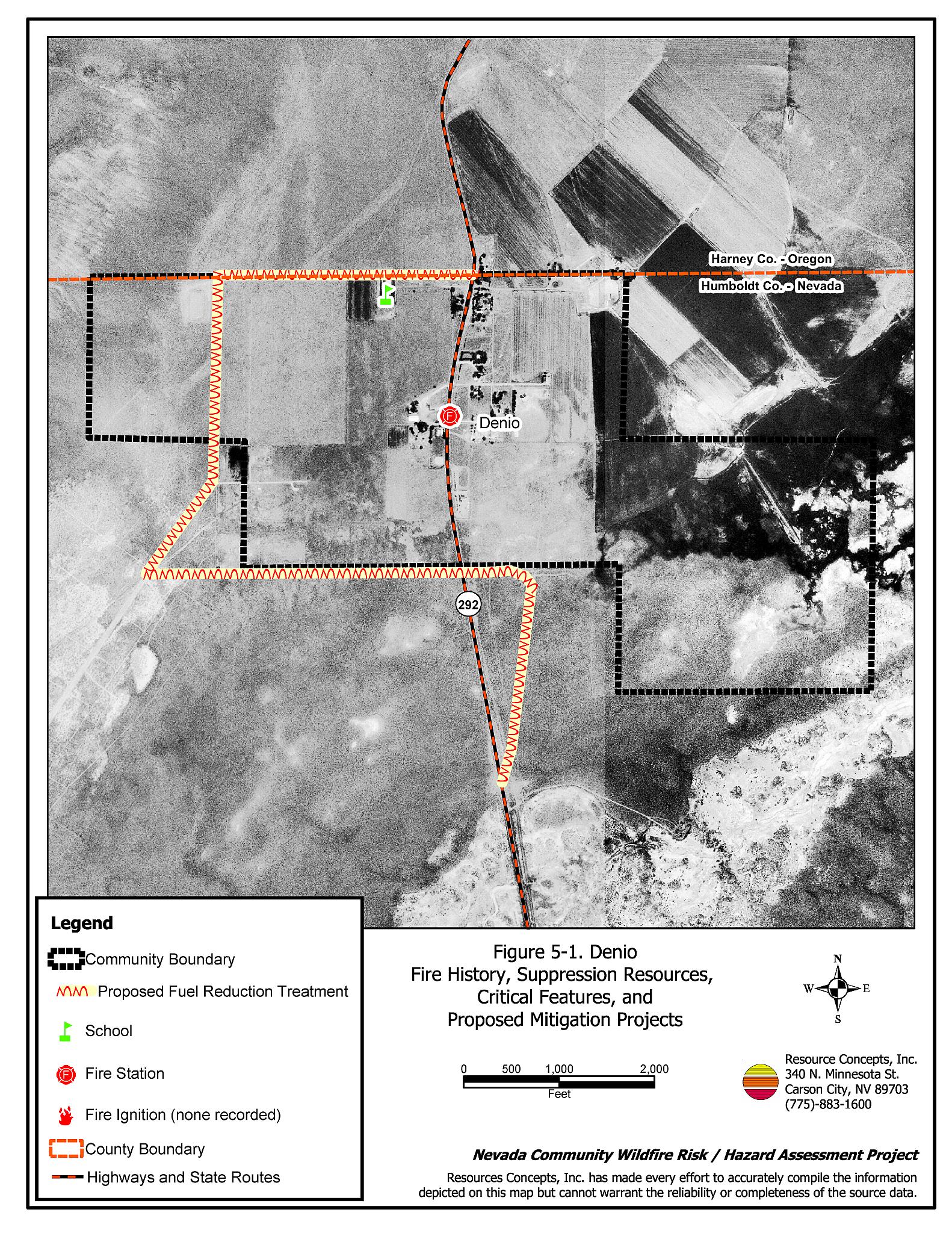
- Extend the roadside fuel reduction treatment to include the north, west, and south perimeter roads as shown in Figure 5-1.
Bureau of Land Management
- Permit livestock grazing prior to seed maturity to reduce cheatgrass. Balance annual stocking rates with annual cheatgrass grass productivity.
Utility Company Responsibilities
- Maintain a minimum fifteen-foot clearance around utility poles and transformers within power line corridors and right-of-ways.
5.2.3 Training and Equipment
Adequate training and equipment are critical to volunteer fire departments, especially those located in remote geographic regions of Humboldt County such as Denio.
Nevada State Fire Marshall
- Provide structure firefighting training to all volunteer fire personnel to meet the minimum State of Nevada Fire Marshal standards.
Humboldt County and Pueblo Fire Protection District
- Seek grant funding for improvements to construct a new fire station at the south end of the Fire Protection District to house fire suppression equipment that is currently kept outside on a local ranch. The Nevada Fire Safe Council can assist with identifying funding opportunities.
Bureau of Land Management and Nevada Division of Forestry
- Assist Pueblo Fire Protection District and Denio Volunteer Fire Department with administration of the Red Card System.
- Provide wildland firefighting training to meet the minimum standards for Red Card qualifications including Wildland Safety Training and fire shelter use.
5.2.4 Community Coordination and Public Education
Many of the most effective activities aimed at reducing the threat of wildfire for the Denio community require that individual property owners coordinate with each other and with local fire authorities. Public education and awareness, neighbors helping neighbors, and proactive individuals setting examples for others to follow are just some of the approaches that will be necessary to meet the fire safe goals in the community.
Property Owner Responsibility
- Coordinate with the community of Denio Junction to form a local chapter of the Nevada Fire Safe Council. The Nevada Fire Safe Council facilitates solutions to reduce the loss of lives and property from wildfire in Nevada’s communities. Through the establishment of a local Chapter, local communities will become part of a large network for sharing information, including notification of programs and funding opportunities for fire mitigation projects such as those listed in this report. The Nevada Fire Safe Council will accept and manage grants and contracts on the Chapter’s behalf through its non-profit status. The Nevada Fire Safe Council will provide assistance and support to communities to complete fire safe plans, set priorities, educate and train community members and promote success stories of its members. To form a local Chapter or for more information contact the:
Nevada Fire Safe Council
1187 Charles Drive
Reno, Nevada 89509
(775) 322-2413
www.nvfsc.org
Denio Volunteer Fire Department
- Distribute copies of the publication Living with Fire to all property owners. This publication is free of charge and copies can be requested from the University of Nevada Cooperative Extension.
- Contact the Bureau of Land Management Winnemucca Field Office and the University of Nevada Cooperative Extension for assistance with public education.
5.3 Summary of Recommendations
| Responsible Party |
Recommended Treatment |
Recommendation Description |
|---|---|---|
| Property Owners | Defensible Space | Remove, reduce, and replace vegetation around homes according to the defensible space guidelines in Appendix E. |
| Fuels Reduction | Remove Russian thistle in vacant lots and maintain reduced fuels. | |
| Community Coordination and Education | Coordinate with the community of Denio Junction to form a local chapter of the Nevada Fire Safe Council. | |
| Bureau of Land Management | Fuels Reduction | Permit livestock grazing prior to seed maturity to reduce cheatgrass. Balance annual stocking rates with annual cheatgrass grass productivity. |
| Bureau of Land Management Nevada Division of Forestry |
Training and Equipment | Assist Pueblo Fire Protection District and Denio VFD with administration of the Red Card System. Provide wildland firefighting training to meet the minimum standards for Red Card qualifications. |
| Bureau of Land Management Humboldt County |
Fuels Reduction | Continue to mow or remove vegetation within 20 feet of both sides of roads. Extend roadside fuels reduction treatments along the north, west and south perimeter roads (see Figure 5-1). |
| Humboldt County | Defensible Space | Revise codes and ordinances to require and enforce defensible space treatments on all lots in the interface area. Require provisions for fuel reduction treatment implementation and maintenance as a condition of new subdivision approval in the interface areas. |
| Training and Equipment | Pursue grant funding for new fires station construction at the south end of the Pueblo Fire Protection District. | |
| Utility Company | Fuels Reduction | Reduce and remove vegetation with 15 feet of poles and transformers. |
| Nevada State Fire Marshal | Training and Equipment | Provide structure firefighting training to all volunteer fire fighters to meet minimum State standards. |
| Denio Volunteer Fire Department | Public Education | Distribute copies of “Living With Fire” to property owners. Contact the BLM Winnemucca Field Office and University of Nevada Cooperative Extension for assistance with public education. |
Figure 5-1Denio Fire History, Suppression Resources, Critical Features, and Proposed Mitigation Projects |
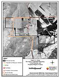 |
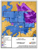
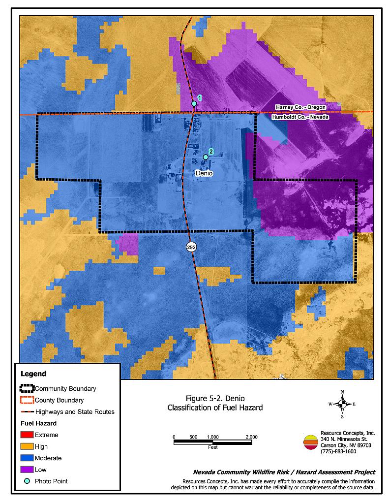
Figure 5-2Denio Classification of Fuel Hazard |
 |
Figure 5-3. Denio Fuel Hazard Photo Points
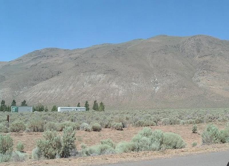
Photo Point 1. 4650391N, 364595E, 290°NW. North of Denio, the fuel load is approximately four to five tons per acre dominated by three-foot tall sagebrush and rabbitbrush shrubs, with a fine fuel component of cheatgrass. As slope increases to the west, the fuel hazard increases from moderate to high.
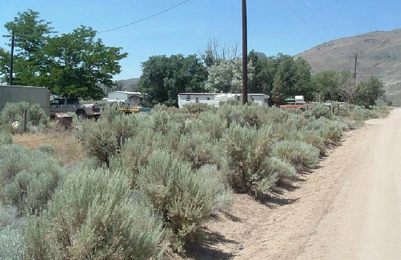
Photo Point 2. 4649972N, 364685E, 240°SW. This photo in Denio shows an example of dense sagebrush within the community and the need for fuel reduction and defensible space treatments.
Table 5-3Denio Wildfire Hazard Rating Summary |
 |