![]()
![]()
6.0 Denio Junction
6.1 Risk and Hazard Assessment
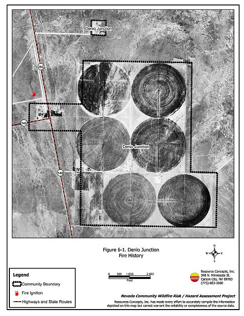
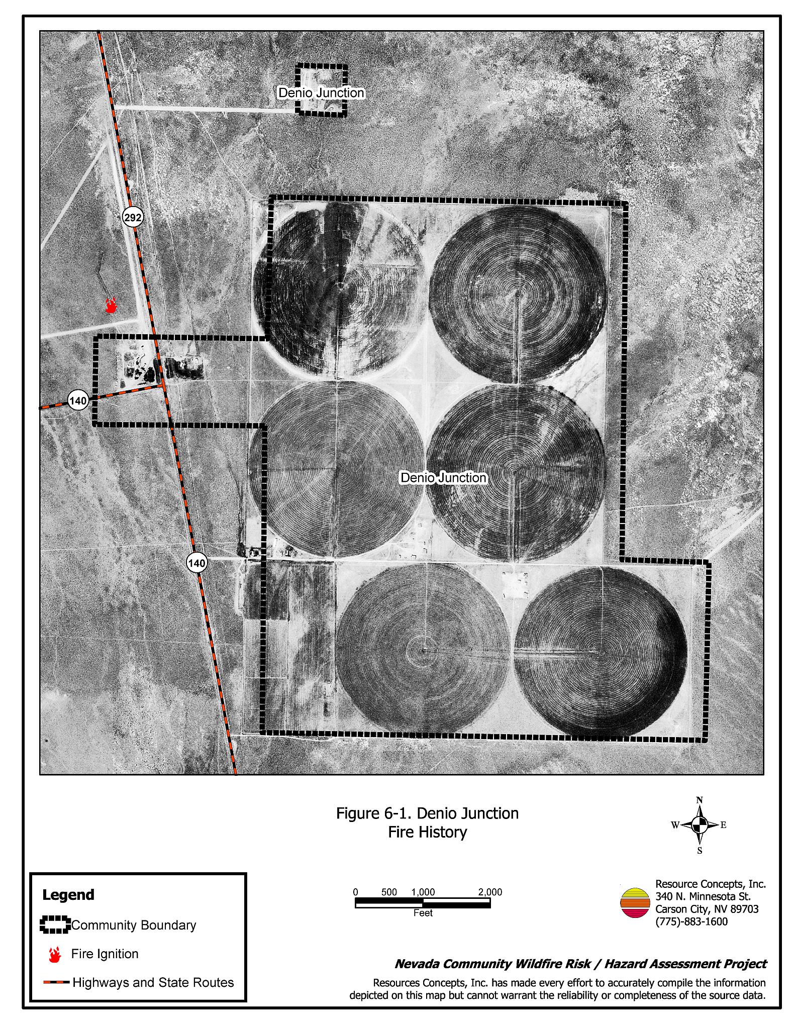
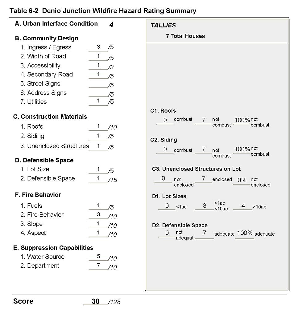
Denio Junction is located in northern Humboldt County at the junction of State Routes 140 and 292, just south of the Nevada-Oregon border. Denio Junction is situated in a valley surrounded by steep slopes. The community is mostly on flat terrain with irrigated agricultural fields to the east and the south. Seven residences were observed during the assessment, which resulted in classifying Denio Junction in the Low Hazard category (30 points). Denio Junction was determined to have good defensible space, non-flammable building materials, and sparse fuels in the urban interface area. A summary of the factors that contributed to the community hazard rating is included in Table 6-2.
6.1.1 Community Design
Denio Junction has a classic wildland-urban interface condition with a clear line of demarcation between wildland fuels and the residential structures in the community. Three of the lots assessed were on parcels of less than one acre; four parcels were between one and ten acres in size.
- Roads: State Routes 140 and 292 are the major transportation routes through Denio Junction. Both roads are paved and are at least 24 feet in width, providing adequate space for two-vehicle passage and for fire suppression equipment to maneuver.
- Signage: Denio Junction is a very small community. All of the homes are located along the highway and are easily visible from the community access roads. There would be little chance of fire suppression personnel being unable to locate a particular structure that needed protection even under the low visibility conditions that may occur during a wildfire.
- Utilities: All electric utilities in the community are above ground. Power line corridors have been properly maintained to reduce the ignition risk from sparking power lines.
6.1.2 Construction Materials
All of the homes in the interface were built with non-combustible or ignition resistant siding such as medium density fiberboard (MDF), and non-combustible tile, metal, or composition roofing materials.
None of the homes observed had unenclosed balconies, porches, decks or other architectural features that create drafty areas where firebrands and embers can accumulate, smolder and ignite, rapidly spreading fire to the home.
6.1.3 Defensible Space
All of the homes assessed had the minimum recommended defensible space to help protect the home and minimize damage or loss during a wildfire.
6.1.4 Suppression Capabilities
Wildfire Protection Resources
The Denio Volunteer Fire Department, whose fire station is located three miles to the north, protects Denio Junction. At the time the interviews were conducted for this report, the Denio VFD consisted of eighteen volunteers. Table 5-1 lists wildfire suppression resources available for initial attack to a wildland fire call in Denio Junction. Firefighter qualifications and financial support for the Pueblo Fire Protection District are described in Section 5.1.4.
Bureau of Land Management wildfire suppression resources are available to all Humboldt County communities through cooperative agreements with local fire departments. The equipment listed in Table 4-2 represents resources assigned to the BLM Winnemucca Field Office that are available for dispatch within ten to fifteen minutes of notification of a wildfire. The closest available resources at the time of the dispatch would respond.
Water Sources and Infrastructure
Water availability for fire suppression in Denio Junction includes:
- Community wells, and
- One 10,000-gallon water storage tank.
The water system operates on gravity and electrical pumps. There is no backup emergency generator.
Detection and Communication
The Humboldt County Sheriff’s Office notifies the Denio VFD and the Central Nevada Interagency Dispatch Center of wildfires reported by 911 calls. The Central Nevada Interagency Dispatch Center dispatches both Bureau of Land Management and US Forest Service resources in Humboldt County.
6.1.5 Factors Affecting Fire Behavior
The terrain around Denio Junction is mostly flat. The fuel hazard is low in areas that have previously burned and on irrigated agricultural lands. However, previously burned areas are dominated by cheatgrass, halogeton, and Russian thistle that can result in heavy fuel loads and an increased fire hazard in wet years. Unburned areas in the interface consist primarily of big sagebrush and rabbitbrush with an understory of fine fuels consisting of mustards, cheatgrass, halogeton, and Russian thistle. The fuel load in the burned areas was estimated at less than one ton per acre. The fuel load for the shrublands was estimated at four to five tons per acre.
6.1.6 Worst-Case Wildfire Scenario
The worst-case scenario for Denio Junction would be a dry lightning caused ignition west or southwest of the community that would be driven by high winds through moderately dense fuels into the community. The community relies on firefighting resources from three miles away in Denio, and BLM resources from much further away in Winnemucca. The scenario would be worse if mutual aid resources were dispatched to previous emergency incidents or because of limited volunteer response.
6.1.7 Ignition Risk Assessment
Denio Junction was determined to have a high potential for ignition. There is extensive wildfire history in the area surrounding the community and a high frequency of historic lightning strikes. The primary ignition risk in Denio Junction is lightning, although human caused ignitions are unpredictable and can occur at any time.
6.2 Hazard Reduction Recommendations, Roles, and Responsibilities
The responsibility to keep a community fire safe falls not only on the local fire department, but also on the residents of the community, businesses, and local governments. The Denio Junction risk and hazard reduction recommendations focus on annual maintenance of defensible space, fuel reduction, public education and fire suppression training and equipment for the Denio Volunteer Fire Department.
6.2.1 Defensible Space Treatments
Property Owner Responsibilities
- Continue to maintain defensible space as needed to keep areas around residences and structures lean, clean, and green.
- Immediately remove cleared vegetation to an approved disposal site when implementing defensible space treatments. This material dries quickly and presents a fire hazard if left on site.
Humboldt County Responsibilities
- Revise county codes and ordinances regarding fuel reduction and defensible space for wildland-urban interface areas to:
- Require defensible space or fuel reduction treatments on all developed and undeveloped lots within interface areas. If landowners do not complete defensible space treatments or fuel reduction within an allotted time frame, the landowner should be charged for defensible space services through property tax levies.
- Require fuel reduction treatments and provisions for continued maintenance of the fuel reduction treatments as a condition of approval for new wildland-urban interface subdivisions.
6.2.2 Fuel Reduction Treatments
Permanently reducing the fuel structure over large, continuous blocks of land to a lower volume reduces the risk of a catastrophic wildfire and increases firefighter safety.
Bureau of Land Management and Humboldt County Responsibilities
- Reduce and remove dense, flammable vegetation a minimum distance of twenty feet from the edge of roads by mowing to a height of four inches, resulting in a widened fuelbreak and reduced fuel hazard.
Bureau of Land Management
- Permit livestock grazing prior to see maturity to reduce cheatgrass. Balance annual stocking rates with annual cheatgrass grass productivity.
6.2.3 Training and Equipment
Adequate training and equipment are critical to volunteer fire departments, especially those located in remote geographic regions of Humboldt County such as Denio Junction.
Nevada State Fire Marshall
- Provide structure firefighting training to all volunteer fire personnel to meet the minimum State of Nevada Fire Marshal standards.
Bureau of Land Management and Nevada Division of Forestry
- Assist Pueblo Fire Protection District and Denio Volunteer Fire Department with administration of the Red Card System.
- Provide wildland firefighting training to meet the minimum standards for Red Card qualifications including Wildland Safety Training and fire shelter use.
6.2.4 Community Coordination and Education
Many of the most effective activities aimed at reducing the threat of wildfire for the Denio Junction community require that individual property owners coordinate with each other and with local fire authorities. Public education and awareness, neighbors helping neighbors, and proactive individuals setting examples for others to follow are just some of the approaches that will be necessary to meet the fire safe goals in the community.
Property Owner Responsibility
- Form a local chapter of the Nevada Fire Safe Council. The Nevada Fire Safe Council facilitates solutions to reduce the loss of lives and property from wildfire in Nevada’s communities. Through the establishment of a local Chapter, local communities will become part of a large network for sharing information, including notification of programs and funding opportunities for fire mitigation projects such as those listed in this report. The Nevada Fire Safe Council will accept and manage grants and contracts on the Chapter’s behalf through its non-profit status. The Nevada Fire Safe Council will provide assistance and support to communities to complete fire safe plans, set priorities, educate and train community members and promote success stories of its members. To form a local Chapter or for more information contact the:
Nevada Fire Safe Council
1187 Charles Drive
Reno, Nevada 89509
(775) 322-2413
www.nvfsc.org
Denio Volunteer Fire Department
- Distribute copies of the publication Living with Fire to all property owners. This publication is free of charge and can be requested from the University of Nevada Cooperative Extension.
- Contact the University Cooperative Extension and the BLM Winnemucca Field Office for assistance with public education.
6.3 Summary of Recommendations
| Responsible Party |
Recommended Treatment |
Recommendation Description |
|---|---|---|
| Property Owners | Defensible Space | Continue to maintain adequate defensible space as described in Appendix E. |
| Community Coordination and Education | Coordinate with the community of Denio to form a local chapter of the Nevada Fire Safe Council. | |
| Humboldt County | Defensible Space | Revise codes and ordinances to require and enforce defensible space treatments on all lots in the interface area. Require provisions for fuel reduction treatment implementation and maintenance as a condition of new subdivision approval in the interface areas. |
| Bureau of Land Management Humboldt County |
Fuels Reduction | Continue to mow or remove vegetation within 20 feet of both sides of roads. |
| Bureau of Land Management | Fuels Reduction | Permit livestock grazing prior to seed maturity to reduce cheatgrass. Balance annual stocking rates with annual cheatgrass grass productivity. |
| Bureau of Land Management Nevada Division of Forestry |
Training and Equipment | Assist Pueblo Fire Protection District and Denio VFD with administration of the Red Card System. Provide wildland firefighting training to meet the minimum standards for Red Card qualifications. |
| Denio VFD | Community Coordination and Education | Distribute copies of “Living With Fire” to property owners. Contact the BLM Winnemucca Field Office and University of Nevada Cooperative Extension for assistance with public education. |
| Nevada State Fire Marshal | Training and Equipment | Provide structure firefighting training to all volunteer fire fighters to meet minimum State standards. |
Figure 6-1Denio Junction Fire History |
 |
Table 6-2Denio Junction Wildfire Hazard Rating Summary |
 |