![]()
![]()
8.0 Grass Valley
8.1 Risk and Hazard Assessment
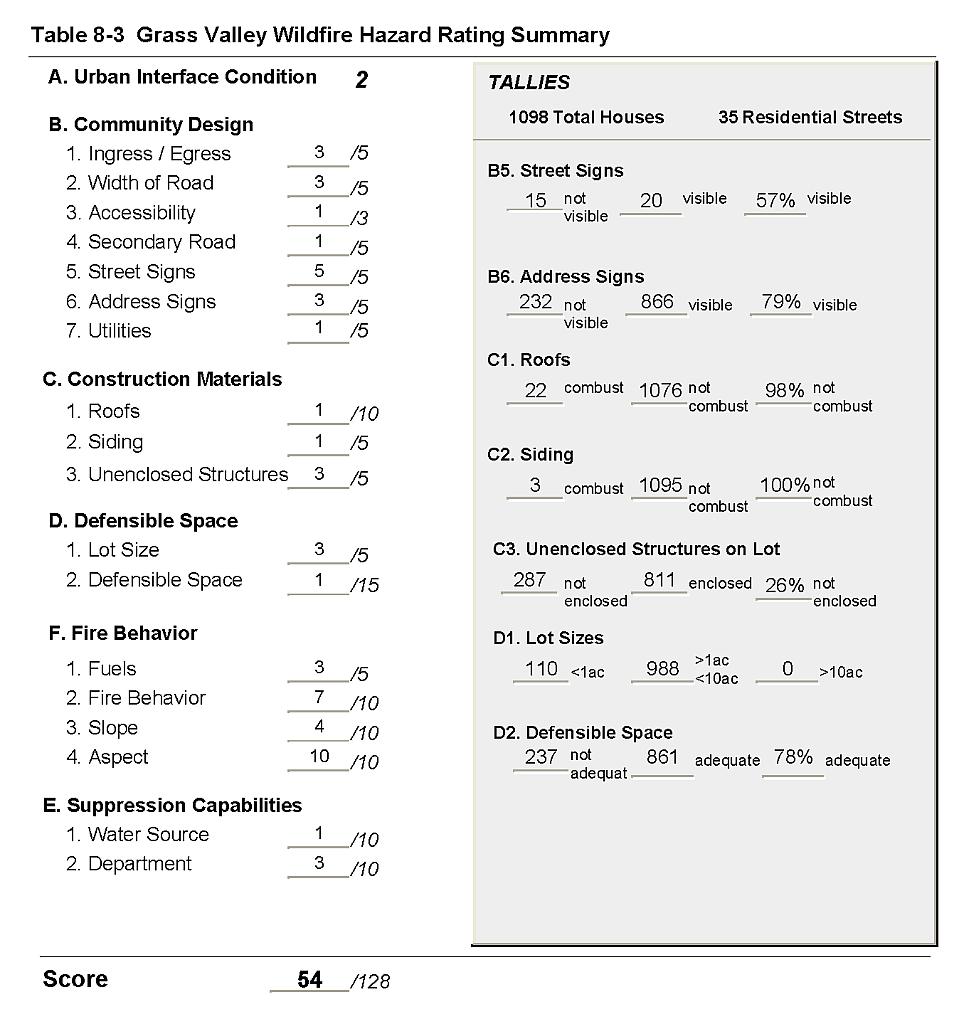
Grass Valley is located in southeast Humboldt County, south of Interstate 80 and south of Winnemucca, extending into Pershing County. Grass Valley is situated just west of Sonoma Peak and at the north end of the East Range. There is a large component of agricultural and livestock use in Grass Valley. The community hazard assessment was based upon observations of over 1,000 residences in Grass Valley and resulted in classifying the community in the Moderate Hazard category (54 points). A summary of the factors that contributed to the hazard rating is included in Table 8-3. Some of the factors that influenced the hazard rating for Grass Valley were limited signage on residences and streets, the fuel hazard within the community, and fuel hazards in the wildland-urban interface, especially on steep slopes that will increase wildfire severity.
8.1.1 Community Design
The wildland-urban interface condition surrounding Grass Valley is intermixed. Structures are scattered throughout the wildland area with no clear line of demarcation between wildland fuels, buildings, and undeveloped open space throughout the community. Approximately ninety percent of the residences observed were on parcels between one and ten acres in size; the remainder were on lots of less than one acre, indicating low density housing overall.
- Roads: State Route 294 (Grass Valley Road) from Winnemucca is the major transportation route to Grass Valley. The road is paved and is at least 24 feet in width, which will adequately accommodate two-vehicle passage and turn-around space for fire suppression equipment. The secondary roads are primarily graded dirt, have a gradient less than five percent, and have adequate width for maneuverability.
- Signage: Over half of the streets did not have easily visible street signs. Residential addresses were visible on about seventy percent of the homes.
- Utilities: All of the utilities are above ground and are well maintained.
8.1.2 Construction Materials
Essentially all of the homes observed in the interface were constructed with fire resistant siding materials such as medium density fiberboard (MDF), a material that only ignites when exposed to high temperatures for a prolonged period of time.
Nearly all of the homes had fire resistant roofing materials (composition, metal, or tile). Approximately one quarter of the homes observed had an unenclosed balcony, porch, deck, or other architectural feature that can create drafty areas where firebrands and embers can accumulate, smolder and ignite, rapidly spreading fire to the home.
8.1.3 Defensible Space
Approximately three-quarters of the homes had the minimum recommended defensible space to help protect the home from damage or loss during a wildfire.
8.1.4 Suppression Capabilities
Wildfire Protection Resources
The Winnemucca Rural Fire Department provides fire suppression for Grass Valley. At the time that interviews were conducted for this report, the Winnemucca Rural Fire Department was staffed by a career Fire Chief and 25 volunteers. Table 8-1 lists the wildfire suppression resources available to respond for initial attack to a wildland fire call in Grass Valley.
| Type of Equipment | Amount of Equipment | Cooperating Partner (Resource Location) |
|---|---|---|
| Engine Type 4 Water Tender Type 1 |
2 1 |
Winnemucca Rural FD (Grass Valley) |
| Source: Personal communication with Chief Neil Wright, Winnemucca Rural Fire Department. | ||
Bureau of Land Management wildfire suppression resources are available to all Humboldt County communities through cooperative agreements with local fire departments. The equipment listed in Table 4-2 represents resources assigned to the BLM Winnemucca Field Office that are available for dispatch within ten to fifteen minutes of notification of a wildfire. The closest available resources at the time of the dispatch would respond.
Water Sources and Infrastructure
Water availability for fire suppression in Grass Valley includes:
- Community wells,
- 500 gpm hydrants within 500 feet of structures in residential areas closer to Winnemucca,
- Draft sources such as ranch ponds in the lower density residential areas, and
- Water storage tanks.
The water system operates on electric pumps with an emergency backup diesel generator in the event of a power failure.
Detection and Communication
The Humboldt County Sheriff’s Office notifies the Winnemucca Rural Fire Department and the Central Nevada Interagency Dispatch Center of wildfires reported by 911 calls. The Central Nevada Interagency Dispatch Center dispatches both Bureau of Land Management and US Forest Service resources in Humboldt County.
Fire Protection Personnel Qualifications
All volunteer firefighters receive training to meet the State of Nevada Firefighter I and II qualifications, and annual BLM Wildland Fire training. The Winnemucca Rural Fire Department does not utilize the Red Card system for individual qualifications. A Red Card certification is part of a fire qualifications management system used by many state and all federal wildland fire management agencies that indicates an individual is qualified to fight wildfires.
Work Load
The Winnemucca Rural Fire Department responded to 54 calls in 2003 as described below:
- 12 wildland/brush fire calls, and
- 42 other calls.
The Winnemucca Rural Fire Department does not respond to emergency medical calls.
Financial Support
Funding for the Winnemucca Rural Fire Department is authorized under NRS 474. Fire protection districts receive funding through ad valorem and other tax revenues.
Community Preparedness
Grass Valley is included in the Humboldt County Local Emergency Planning Committee Emergency Plan. The Plan includes hazardous material response and an all-risk plan. The Winnemucca Rural Fire Department has a wildfire response plan that is updated annually. New development plans are reviewed by the Winnemucca Rural Fire Department to assure compliance with fire safety standards for construction and community design.
8.1.5 Factors Affecting Fire Behavior
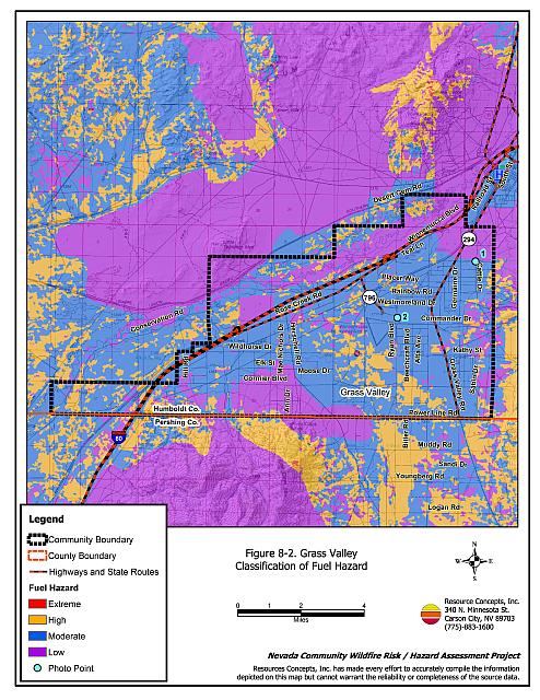
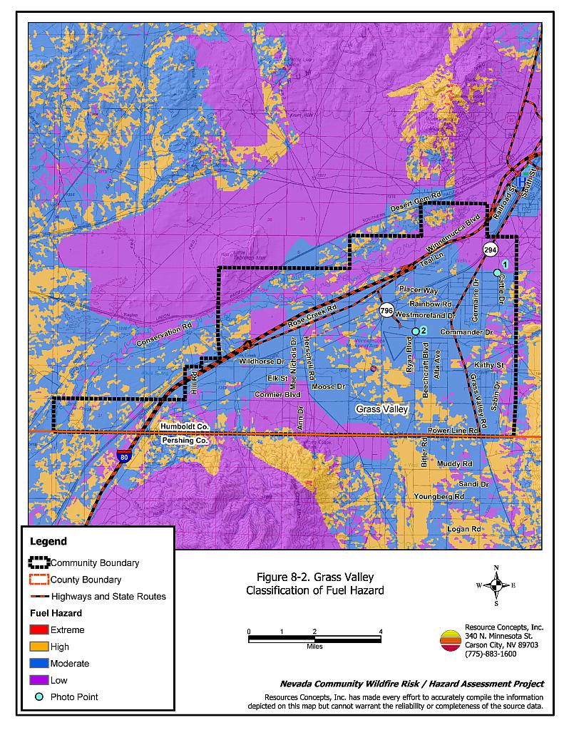
The terrain in Grass Valley varies from about an eight to twenty percent slope. The predominant winds in the late afternoon are from the west and southwest. Most of the area in the interface around Grass Valley has previously burned and is characterized by cheatgrass and some rabbitbrush. The fuel hazard was considered low for the previously burned areas and for irrigated agricultural lands. Shrublands consisted primarily of big sagebrush, rabbitbrush, fourwing saltbush, and greasewood with a fine fuel component of cheatgrass and annual mustard. The fuel load in the shrublands was estimated at three to four tons per acre and was considered a moderate fuel hazard on the flatter terrain. As slope increased, the shrub dominated fuel types transition to a high fuel hazard.
8.1.6 Worst-Case Wildfire Scenario
The worst-case scenario for Grass Valley would be a wind-driven wildfire ignited by dry lightning in late summer. Erratic winds would be expected given the topography and thunderstorm behavior. Any part of the community could be threatened. Cheatgrass would create a receptive fuel bed that would be easily ignited, rapidly spreading fire into adjacent vegetation, structures, farm equipment, or haystacks that have inadequate defensible space around them. This type of wind-driven fire fed by heavy loads of dry cheatgrass could easily exceed 1,000 acres within four to six hours and escape the initial attack resources.
8.1.7 Ignition Risk Assessment
Grass Valley was determined to have a high ignition risk. There is extensive wildfire history around Grass Valley and a regular occurrence of lightning strikes during the summer. The primary ignition risk for Grass Valley is lightning, although human caused ignitions are unpredictable and can occur at any time.
8.2 Hazard Reduction Recommendations, Roles, and Responsibilities
The Grass Valley risk and hazard reduction recommendations focus on improving defensible space and fuels reduction. Other recommendations pertain to community coordination efforts that would enhance fire safety in Grass Valley.
8.2.1 Defensible Space Treatments
Vegetation density, type of fuel, and slope gradient around a home affect the potential fire exposure levels to the home. The first goal of defensible space is to reduce the risk of property loss from wildfire by eliminating flammable vegetation near the home, thereby lowering the potential to ignite and burn in the presence of wildfire. The second goal of defensible space is to provide firefighters a safer working area from which to defend the home or outbuildings during a wildland fire. Defensible space should be the first priority wildfire risk/hazard reduction measure implemented within communities. Guidelines for improving defensible space around residences and structures are described in detail in Appendix E.
Property Owner Responsibilities
- Remove, reduce, and replace vegetation around homes according to the guidelines in Appendix E. The defensible space zone
- Lean: There are only small amounts of flammable vegetation.
- Clean: There is no accumulation of dead vegetation or other flammable debris including woodpiles.
- Green: Existing plants are healthy and green during the fire season.
- Clear all vegetation and combustible materials around propane tanks for a minimum distance of ten feet.
- Where cheatgrass or other annual grasses have become dominant within the defensible space zone, areas should be mowed prior to seed set or treated with an application of pre-emergent herbicide. Treatments may need to be repeated for several years to ensure that the bank of unwanted annual plant seeds has been depleted. Refer to Appendix E for a recommended seed mixture and planting guidelines that can be used in conjunction with cheatgrass or Russian thistle removal.
- Store firewood a minimum distance of thirty feet from structures.
- Maintain the area beneath unenclosed wood decks and porches free of weeds and flammable debris. Screen these areas wherever possible.
- Immediately remove cleared vegetation to an approved disposal site when implementing defensible space treatments. This material dries quickly and presents a fire hazard if left on site.
- Maintain defensible space as needed to keep the space lean, clean, and green.
Humboldt County Responsibilities
- Revise county codes and ordinances regarding fuel reduction and defensible space for wildland-urban interface areas to:
- Require defensible space or fuel reduction treatments on all developed and undeveloped lots within interface areas. If landowners do not complete defensible space treatments or fuel reduction within an allotted time frame, the landowner should be charged for defensible space services through property tax levies.
- Require fuel reduction treatments and provisions for continued maintenance of the fuel reduction treatments as a condition of approval for new wildland-urban interface subdivisions.
8.2.2 Fuel Reduction Treatments
County Responsibilities
- Continue fuel reduction treatments and replacement of roadside vegetation with low growing, fire resistant grasses along road right-of-ways. Mow existing vegetation to a height of four inches for a distance of twenty feet from the edge of pavement on both sides of the road to create a fuelbreak and reduce fuel hazard. Reseed with the recommended seed mixture included in Appendix E if necessary to prevent cheatgrass and other weed invasion.
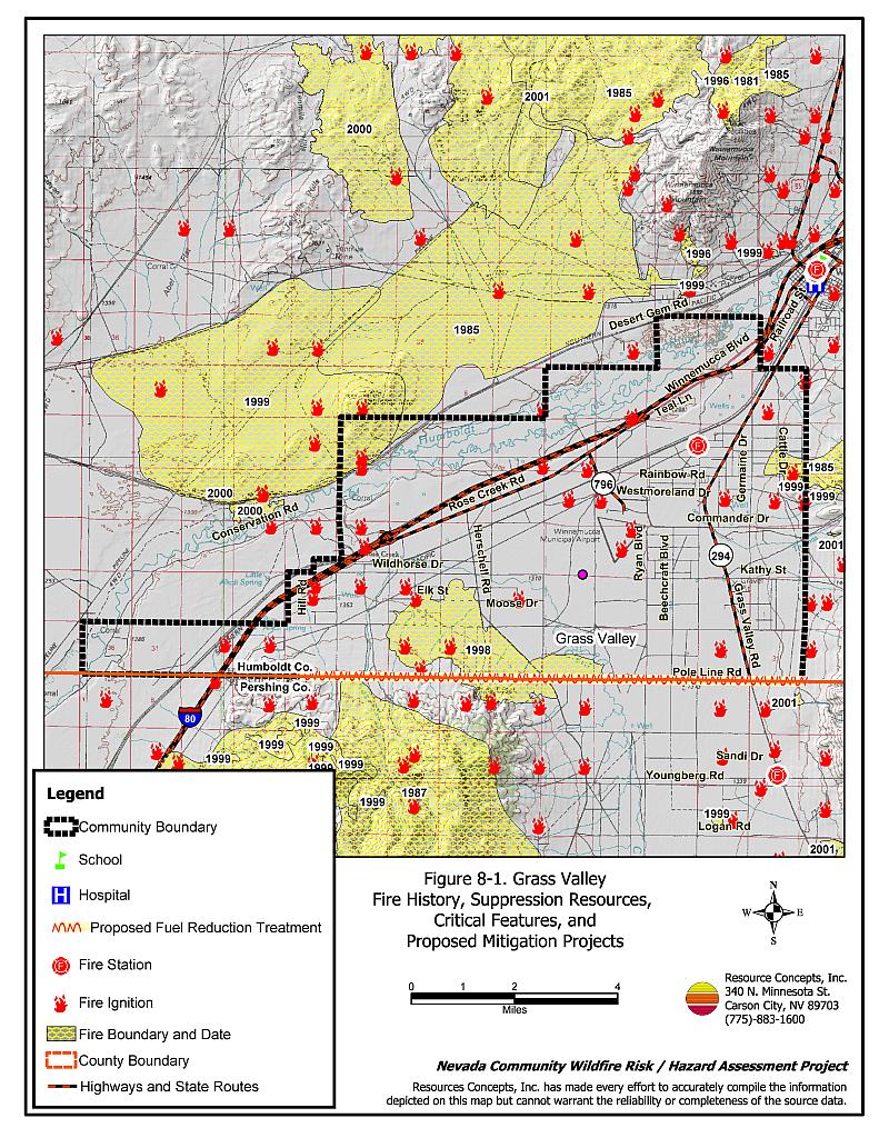
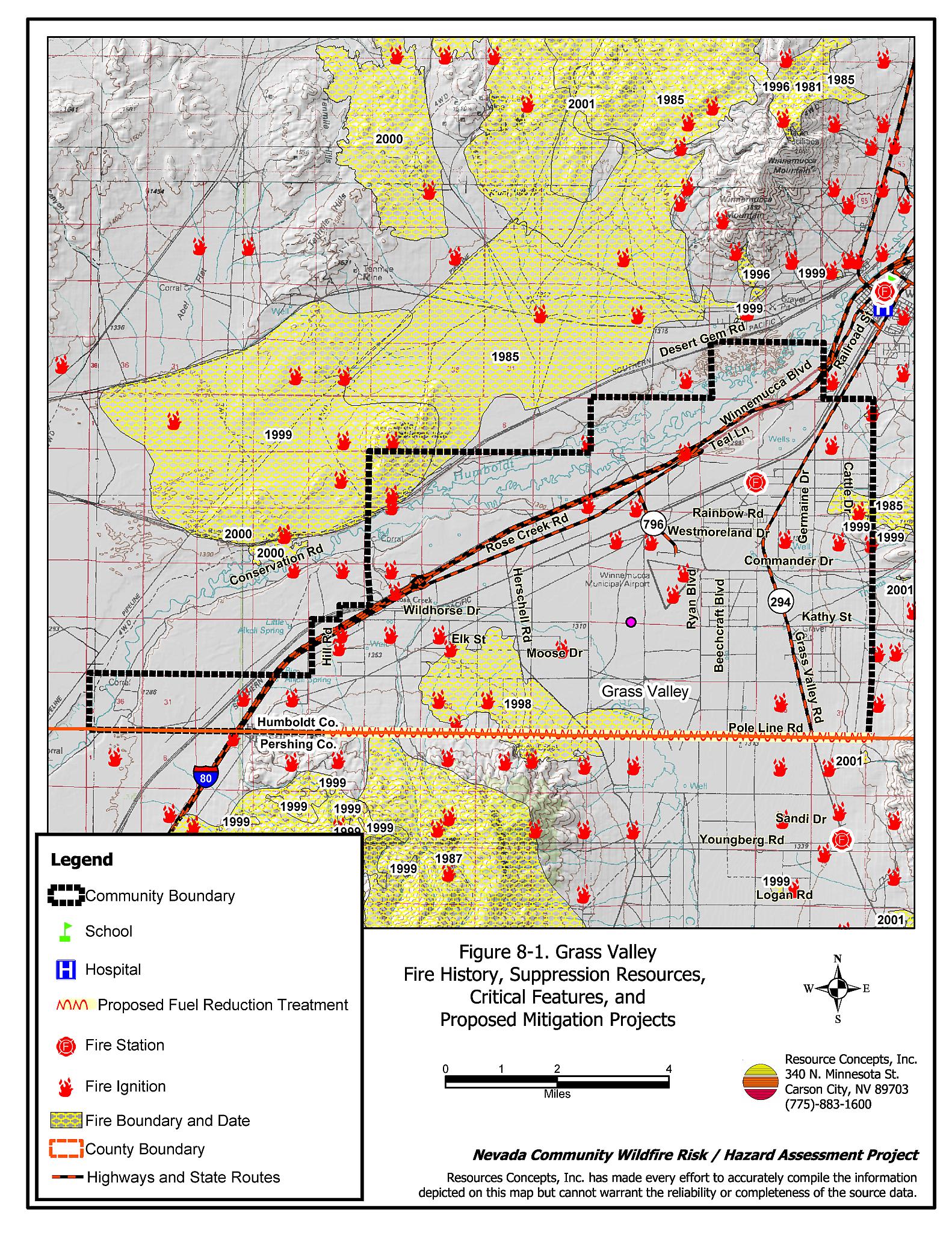
- Extend the roadside fuel reduction treatment to include approximately eleven miles along the Pole Line Road as shown in Figure 8-1.
Bureau of Land Management
- Permit livestock grazing prior to seed maturity to reduce cheatgrass. Balance annual stocking rates with annual cheatgrass grass productivity.
8.2.3 Community Coordination and Education
Many of the most effective activities aimed at reducing the threat of wildfire for the Grass Valley community require that individual property owners coordinate with each other and with local fire authorities. Public education and awareness, neighbors helping neighbors, and proactive individuals setting examples for others to follow are just some of the approaches that will be necessary to meet the fire safe goals in the community.
Property Owner Responsibilities
- Form a local chapter of the Nevada Fire Safe Council. The Nevada Fire Safe Council facilitates solutions to reduce the loss of lives and property from wildfire in Nevada’s communities. Through the establishment of a local Chapter, local communities will become part of a large network for sharing information, including notification of programs and funding opportunities for fire mitigation projects such as those listed in this report. The Nevada Fire Safe Council will accept and manage grants and contracts on the Chapter’s behalf through its non-profit status. The Nevada Fire Safe Council will provide assistance and support to communities to complete fire safe plans, set priorities, educate and train community members and promote success stories of its members. To form a local Chapter or for more information contact the:
Nevada Fire Safe Council
1187 Charles Drive
Reno, Nevada 89509
(775) 322-2413
www.nvfsc.org
- Assure that residential addresses and street signs are visible from the main roads. Address characters should be at least four inches high, reflective, and composed of non-flammable material. Improving visibility of addresses will make it easier for those unfamiliar with the area to navigate under smoky conditions in the event of a wildland fire.
- Mow or remove brush growing against all fences in the community.
Winnemucca Rural Fire Department Responsibilities
- Distribute copies of the publication Living with Fire to all property owners. This publication is free of charge and can be obtained from the University of Nevada Cooperative Extension.
- Contact the BLM Winnemucca Field Office and University of Nevada Cooperative Extension for assistance with public education.
8.3 Summary of Recommendations
| Responsible Party | Recommended Treatment | Recommendation Description |
|---|---|---|
| Property Owners | Defensible Space | Remove, reduce, and replace vegetation around homes according to the defensible space guidelines in Appendix E. |
| Community Coordination and Education | Form a local chapter of the Nevada Fire Safe Council Assure address sign visibility from the road. Mow or remove brush growing against fences. |
|
| Humboldt County | Defensible Space | Revise codes and ordinances to require and enforce defensible space treatments on all lots in the interface area. Require provisions for fuel reduction treatment implementation and maintenance as a condition of new subdivision approval in the interface areas. |
| Fuels Reduction | Continue roadside fuel reduction treatments by mowing within 20 feet of each side of the roads. Reseed when necessary to prevent cheatgrass and weed invasion. Extend roadside fuels reduction treatment along Pole Line Road (see Figure 8-1). |
|
| Bureau of Land Management | Fuels Reduction | Permit livestock grazing prior to seed maturity to reduce cheatgrass. Balance annual stocking rates with annual cheatgrass grass productivity. |
| Winnemucca Rural Fire Department | Community Coordination and Education | Distribute copies of “Living With Fire” to property owners. Contact the BLM Winnemucca Field Office and University of Nevada Cooperative Extension for assistance with public education. |
Figure 8-1Grass Valley Fire History, Suppression Resources, Critical Features, and Proposed Mitigation Projects |
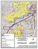 |
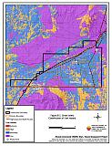
Figure -2Grass Valley Classification of Fuel Hazard |
 |
Figure 8-3. Grass Valley Fuel Hazard Photos
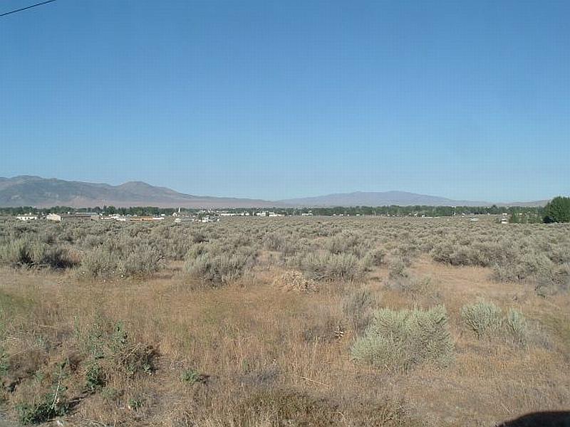
Photo Point 1. 4531193N, 437107E, 240°SW. This photo in Grass Valley shows the moderate fuel hazard associated with a sagebrush / rabbitbrush shrubland with a fine fuel component of cheatgrass.
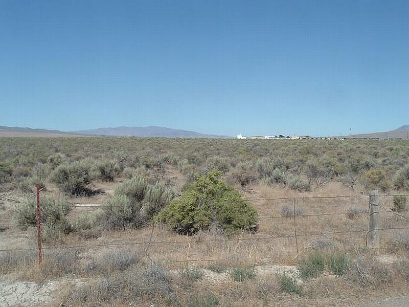
Photo Point 2. 4528334N, 433128E, 270°W. This photo, taken east of the Winnemucca Municipal Airport, illustrates the moderate fuel hazard in the interface area. This fuel load was estimated at three to four tons/acre.
Table 8-3Grass Valley Wildfire Hazard Rating Summary |
 |