![]()
![]()
9.0 McDermitt
9.1 Risk and Hazard Assessment
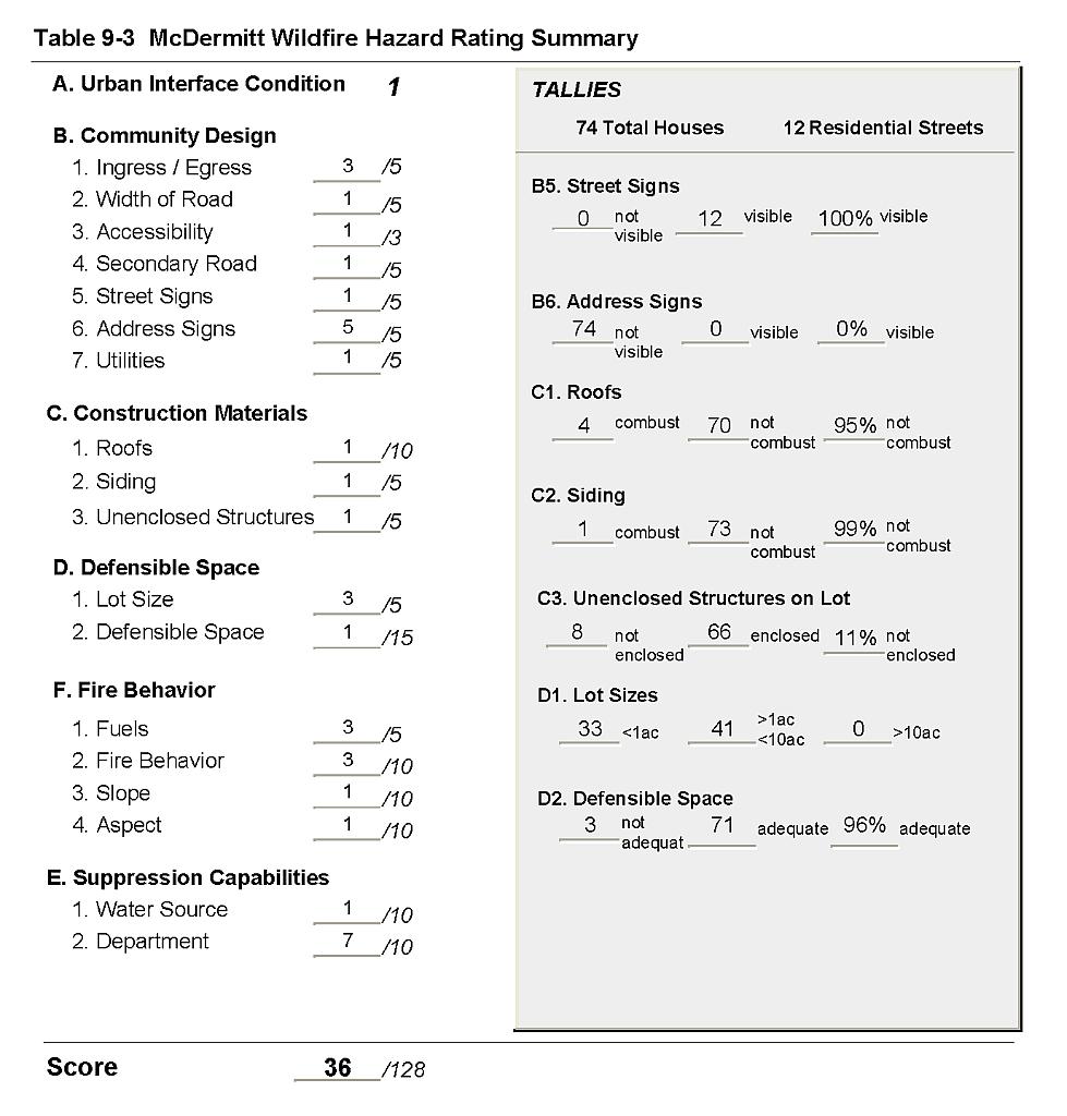
McDermitt is located in north-central Humboldt County on the Nevada-Oregon border. The risk assessment resulted in classifying McDermitt in the Low Hazard category (36 points). A summary of the factors that contributed to the hazard rating is included in Table 9-3. The primary factors that contributed to the rating were good access and flat terrain, good defensible space, and the prevalence of ignition resistant or non-combustible building materials.
9.1.1 Community Design
McDermitt has a classic interface condition where structures abut wildland with no continuation of wildland fuels into the residential area. Of the 74 homes that were assessed in the interface, 33 were on lots of one acre or less, and 41 homes were on parcels greater than one acre in size, indicating a moderate housing density.
- Roads: US Highway 95 is the only major transportation route through McDermitt. The Highway is paved and at least 24 feet in width, allowing for adequate vehicle passage and fire suppression equipment maneuverability.
- Signage: All of the streets signs were easily visible in the community. However, none of the homes observed had posted addresses.
- Utilities: Utilities were all above ground. Many areas beneath power lines are in need of vegetation clearing and thinning.
9.1.2 Construction Materials
Only one of the 74 homes observed in the interface was built with combustible siding materials. Ninety-five percent of the homes had fire resistant roofing such as composition shingles or metal. Eleven percent of the homes observed had an unenclosed balcony, porch, deck or other architectural features that can create drafty areas where firebrands and embers can accumulate, smolder and ignite, rapidly spreading fire to the home.
9.1.3 Defensible Space
Ninety-six percent of the homes in the interface met the minimum recommended defensible space required to protect the home and minimize the potential for damage or loss during a wildfire.
9.1.4 Suppression Capabilities
Wildfire Protection Resources
The McDermitt Volunteer Fire Department, through the McDermitt Fire Protection District, provides fire suppression for McDermitt. At the time that interviews were conducted for this report, the McDermitt VFD had sixteen volunteer members. Table 9-1 lists wildfire suppression resources available for initial attack on a wildland fire call in McDermitt.
| Type of Equipment | Amount of Equipment | Cooperating Partner (Resource Location) |
|---|---|---|
| Engine Type 3 Engine Type 1 Engine Type 4 |
3 1 1 |
McDermitt VFD (McDermitt) |
| Source: Personal communication with Chief Jess Jaca, McDermitt Volunteer Fire Department. | ||
The fire suppression apparatus belonging to the McDermitt VFD is old and needs to be replaced with updated equipment.
The Bureau of Land Management stations fire engines and personnel at the Fort McDermitt substation during the fire season that are available to respond for initial attack to a wildfire call near McDermitt.
Additional Bureau of Land Management wildfire suppression resources are available to all Humboldt County communities through cooperative agreements with local fire departments. The equipment listed in Table 4-2 represents resources assigned to the BLM Winnemucca Field Office that are available for dispatch within ten to fifteen minutes of notification of a wildfire. The closest available resources at the time of the dispatch would respond.
Water Sources and Infrastructure
Water availability for fire suppression in McDermitt includes:
- 500 gpm hydrants within 1,000 feet of structures,
- One 60,000 gallon water storage tank, and one 260,000-gallon capacity water tank, and
- Community wells.
The community water system operates on gravity and electrical pumps. There is an emergency backup generator to run the pumps in the event of a power failure during a wildfire.
Detection, Communication
The Humboldt County Sheriff’s Office notifies the McDermitt Volunteer Fire Department and the Central Nevada Interagency Dispatch Center of wildfires reported by 911 calls. The Central Nevada Interagency Dispatch dispatches both Bureau of Land Management and US Forest Service resources in Humboldt County.
Fire Protection Personnel Qualifications
All volunteer firefighters receive BLM Wildland Firefighting training. The McDermitt VFD does not utilize the Red Card system for individual qualifications. A Red Card certification is part of a fire qualifications management system used by many state and all federal wildland fire management agencies to indicate an individual is qualified to fight wildfires.
Work Load
The McDermitt VFD responded to five calls in 2003. Two of these were wildland/brush fire calls. The McDermitt VFD does not respond to most emergency medical calls, although they do respond to vehicle accidents.
Financial Support
Funding for the McDermitt VFD comes through the organization of the McDermitt Fire Protection District, authorized under NRS 474. Fire Protection Districts generally receive funding through ad valorem and other tax revenues.
Community Preparedness
McDermitt has no emergency or disaster plans. The McDermitt VFD reviews community development plans, and there is a brush clearance program in effect.
9.1.5 Factors Affecting Fire Behavior
McDermitt lies in the middle of a north-south oriented valley with mountains to the east and west. The terrain in the interface is mostly flat with a north aspect. Late afternoon winds are predominantly from the southwest. The fuel hazard in the McDermitt interface area varies from low in abandoned agricultural fields and burned areas, to moderate in the interface area west of town. Fuels west of the community consist primarily of big sagebrush, fourwing saltbush, and rabbitbrush with a fine fuel component of cheatgrass and annual mustards. Vegetation in the burned area consists primarily of cheatgrass and annual mustard, with some rabbitbrush. Great Basin wildrye and rabbitbrush are the prevalent fuels southwest of McDermitt.
9.1.6 Worst-Case Wildfire Scenario
The area around McDermitt has a history of dry lightning during summer thunderstorms. The worst-case scenario for the community would begin with a lightning caused ignition in the dense vegetation south to southwest of town. Prevailing winds would push the fire north into the community. In years with higher than normal precipitation, high cheatgrass production would produce extreme fire behavior that would threaten nearby structures. The scenario would be worse if mutual aid resources were dispatched to a previous incident or because volunteer response was limited.
9.1.7 Ignition Risk Assessment
The ignition risk for McDermitt was determined to be high based on previous ignition and lightning strike history in the area. The primary ignition risk in McDermitt is lightning, although human caused ignitions are unpredictable and can occur at any time.
9.2 Hazard Reduction Recommendations, Roles, and Responsibilities
The responsibility to keep a community fire safe falls not only on the local fire department but also on the residents of the community, businesses, and local governments. The McDermitt risk and hazard reduction recommendations focus primarily on implementing and maintaining defensible space, fuel reduction treatments along roads, power line corridors, electrical transfer stations, and improvement of fire suppression equipment and resources.
9.2.1 Defensible Space Treatments
Vegetation density, type of fuel, and slope gradient around a home affect the potential fire exposure levels to the home. The first goal of defensible space is to reduce the risk of property loss from wildfire by eliminating flammable vegetation near the home, thereby lowering the potential to burn. The second goal of defensible space is to provide firefighters a safer working area from which to defend the home or outbuildings during a wildland fire. Guidelines for improving defensible space around residences and structures are described in detail in Appendix E.
Property Owner Responsibilities
- Remove, reduce, and replace vegetation around homes according to the guidelines in Appendix E. The defensible space zone
- Lean: There are only small amounts of flammable vegetation.
- Clean: There is no accumulation of dead vegetation or other flammable debris including woodpiles.
- Green: Existing plants are healthy and green during the fire season.
- Clear all vegetation and combustible materials around propane tanks for a minimum distance of ten feet.
- Store firewood a minimum distance of thirty feet from structures.
- Maintain the area beneath unenclosed wood decks and porches free of weeds and flammable debris. Screen these areas wherever possible.
- Where cheatgrass or other annual grasses have become dominant within the defensible space zone, areas should be mowed prior to seed set or treated with an application of pre-emergent herbicide. Treatments may need to be repeated for several years to ensure that the bank of unwanted annual plant seeds has been depleted. Refer to Appendix E for a recommended seed mixture and planting guidelines that can be used in conjunction with cheatgrass or Russian thistle removal.
- Immediately remove cleared vegetation to an approved disposal site when implementing defensible space treatments. This material dries quickly and presents a fire hazard if left on site.
- Maintain defensible space as needed to keep the space lean, clean, and green.
Humboldt County Responsibilities
- Revise county codes and ordinances regarding fuel reduction and defensible space for wildland-urban interface areas to:
- Require defensible space or fuel reduction treatments on all developed and undeveloped lots within interface areas. If landowners do not complete defensible space treatments or fuel reduction within an allotted time frame, the landowner should be charged for defensible space services through property tax levies.
- Require fuel reduction treatments and provisions for continued maintenance of the fuel reduction treatments as a condition of approval for new wildland-urban interface subdivisions.
9.2.2 Fuels Reduction Treatments
McDermitt Volunteer Fire Department
- Mow or otherwise remove all vegetation within ten feet of all fire hydrants to improve visibility and access for fire personnel.
Humboldt County Responsibilities
- Continue fuel reduction treatments and replacement of roadside vegetation with low growing, fire resistant grasses along road right-of-ways. Mow existing vegetation to a height of four inches for a distance of twenty feet from the edge of pavement on both sides of road to create a fuelbreak and reduce fuel hazard. Reseed with the recommended seed mixture included in Appendix E if necessary to prevent cheatgrass and other weed invasion.
Utility Company Responsibilities
- Maintain a clearance of all vegetation within a minimum of thirty feet around all electrical transfer stations.
- Clear and maintain a minimum space of fifteen feet free of accumulated vegetation around utility poles and transformers within power line corridors.
Nevada Department of Transportation Responsibilities
- Continue to reduce vegetation and maintain a minimum space of twenty feet from the edge of pavement on US 95 by mowing to a height of four inches on both sides of road. The biomass should be removed to an appropriate site for disposal.
Bureau of Land Management
- Permit livestock grazing prior to seed maturity to reduce cheatgrass. Balance annual stocking rates with annual cheatgrass grass productivity.
9.2.3 Training and Equipment
McDermitt Volunteer Fire Department Responsibilities
- Pursue grants or state and federal excess property programs for equipment purchases to upgrade fire suppression equipment.
- Provide personal protective equipment approved for wildland firefighting for all volunteers.
Nevada State Fire Marshall
- Provide structure firefighting training to all volunteer fire personnel to meet the minimum State of Nevada Fire Marshal standards.
Humboldt County Responsibility
- Develop a Mutual Aid Agreement between Humboldt County and Malheur County, Oregon for fire protection of structures and wildfire response in McDermitt, Oregon.
9.2.4 Community Coordination and Education
Public education focused on increasing community fire safety is critical. A program that explains fire safe measures in clear and emphatic terms will have an impact on residents in the wildland-urban interface. Informed community members will be more inclined to take actions to effectively reduce fuels and other wildfire hazards around their home and in their neighborhoods.
Property Owner Responsibilities
- Assure that address signs are visible from the road. Address characters should be at least four inches high, reflective, and composed of non-flammable material. Improving visibility of addresses will make it easier for those unfamiliar with the area to navigate under smoky conditions during a wildland fire.
- Windows and doors in abandoned buildings should be boarded up. Abandoned trailers should be removed, or the windows and doors should be boarded up and the underneath skirted to reduce the potential for ignition from sparks or firebrands.
McDermitt Volunteer Department Responsibilities
- Distribute copies of the publication Living with Fire to all property owners. This publication is free of charge and can be obtained from the University of Nevada Cooperative Extension.
- Contact the BLM Winnemucca Field Office and University of Nevada Cooperative Extension for assistance with public education.
9.3 Summary of Recommendations
| Responsible Party | Recommended Treatment | Recommendation Description |
|---|---|---|
| Property Owners | Defensible Space | Remove, reduce, and replace vegetation around homes according to the defensible space guidelines in Appendix E. |
| Community Coordination and Education | Assure address sign visibility from the road. Board-up windows and doors of abandoned structures and skirt all trailers. |
|
| McDermitt VFD | Fuels Reduction | Mow or remove vegetation within ten feet of fire hydrants. |
| Training and Equipment | Pursue grant funding and state federal excess property programs to replace outdated equipment. Provide personal protective equipment to volunteers. |
|
| Community Coordination and Education | Distribute copies of “Living With Fire” to property owners. Contact the BLM Winnemucca Field Office and University of Nevada Cooperative Extension for assistance with public education. |
|
| Humboldt County | Defensible Space | Revise codes and ordinances to require and enforce defensible space treatments on all lots in the interface area. Require provisions for fuel reduction treatment implementation and maintenance as a condition of new subdivision approval in the interface areas. |
| Fuels Reduction | Continue roadside fuel reduction treatments by mowing within 20 feet of each side of the roads. | |
| Training and Equipment | Develop Mutual Aid Agreement between Humboldt County and Malheur County, Oregon for structure protection and wildfire response. | |
| Utility Company | Fuels Reduction | Reduce and remove vegetation with 15 feet of poles and transformers. Maintain 30 foot vegetation clearance around all electrical transfer stations. |
| Nevada Department of Transportation | Fuels Reduction | Continue mowing vegetation and maintain a minimum area of 20 feet from the edge on both sides of Highway 95. Remove and dispose of biomass at an approved site. |
| Bureau of Land Management | Fuels Reduction | Permit livestock grazing prior to seed maturity to reduce cheatgrass. Balance annual stocking rates with annual cheatgrass grass productivity. |
| Nevada State Fire Marshal | Training and Equipment | Provide structure firefighting training to all volunteer fire fighters to meet minimum State standards. |
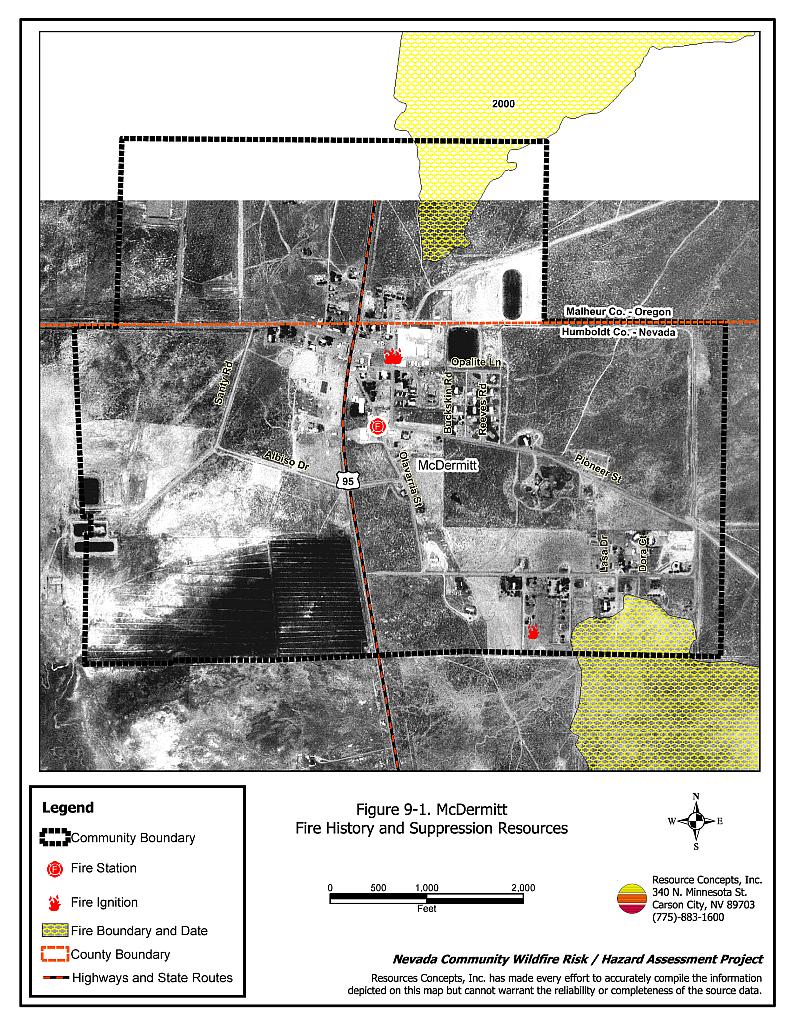
Figure 9-1McDermitt Fire History and Suppression Resources |
 |
Table 9-3McDermitt Wildfire Hazard Rating Summary |
 |