![]()
![]()
10.0 Orovada
10.1 Risk and Hazard Assessment
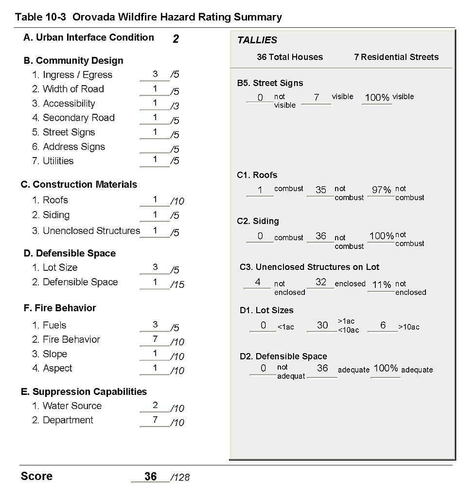
Orovada is located in north-central Humboldt County along US Highway 95, 44 miles north of Winnemucca. Assessment of 36 residences in Orovada resulted in classifying the community in the Low Hazard category (36 points). A summary of the factors that contribute to this hazard rating is included in Table 10-3. The low community hazard score is attributed to adequate defensible space, ignition-resistant or non-combustible construction materials, and good community design.
10.1.1 Community Design
The wildland-urban interface condition in Orovada is intermixed. Structures are scattered throughout the wildland area with no clear line of demarcation between wildland fuels and residential structures in the community. Of the 36 homes observed during the assessment, thirty were on lot sizes between one and ten acres, and six residences were on parcels of greater than ten acres. The low density housing implies a lower community hazard because fire would be less likely to rapidly spread from one structure to another.
- Roads: US Highway 95 is the major transportation route through the community of Orovada. US Highway 95 is a paved highway greater than 24 feet wide. Most of the secondary roads through Orovada are of adequate width and gradient to allow two-vehicle passage and fire apparatus maneuverability.
- Signage: All streets signs were easily visible throughout the community.
- Utilities: Utilities were all above ground, and include propane tanks.
10.1.2 Construction Materials
All of the homes in the interface were built with non-combustible or ignition resistant siding material such as medium density fiberboard (MDF), a fire-resistant material that can withstand prolonged periods of exposure to radiant heat.
All but one of the homes observed had fire resistant roofing such as composition shingles or metal. A small number of the homes observed had an architectural feature such as an unenclosed balcony, porch, or deck that could create drafts and provide a space where firebrands and embers can accumulate, smolder and ignite, rapidly spread fire to the home.
10.1.3 Defensible Space
All of the homes assessed had landscaping that meets the minimum requirements recommended for defensible space to help protect the home and minimize the potential for damage or loss during a wildfire. However there are outbuildings and other structures in the community, as well as equipment and hay storage areas, that do not have sufficient clearance of wildland vegetation.
10.1.4 Suppression Capabilities
Wildfire Protection Resources
The twenty-member Orovada Volunteer Fire Department. Table 10-1 lists wildfire suppression resources available for initial attack on a wildland fire call in Orovada.
| Type of Equipment | Amount of Equipment | Cooperating Partner (Resource Location) |
|---|---|---|
| Engine Type 3 Engine Type 4 Engine Type 1 Water Tender |
2 1 1 2 |
Orovada VFD (Orovada) |
| Source: Personal communication with Chief Dave Black, Orovada Volunteer Fire Department. | ||
Orovada VFD also has mutual aid agreements with the Winnemucca Rural Fire Department and the US Forest Service for initial attack on wildland fires in the Orovada Fire Protection District.
Bureau of Land Management wildfire suppression resources are available to all Humboldt County communities through cooperative agreements with local fire departments. The equipment listed in Table 4-2 represents resources assigned to the BLM Winnemucca Field Office that are available for dispatch within ten to fifteen minutes of notification of a wildfire. The closest available resources at the time of the dispatch would respond.
Water Sources and Infrastructure
Water availability for fire suppression in Orovada includes:
- Community wells,
- 500 gpm fire hydrants within 1,000 feet of structures in the Kunkel Lane subdivision,
- A fire hydrant at the Orovada Volunteer Fire Station, and
- One water storage tank with a 250,000 gallon capacity.
Ranch ponds could be used as water sources in the event of a wildfire. The water system operates on gravity and electrical pumps. There is no backup emergency generator to run the pumps in the event of a power failure during a wildfire.
Detection and Communication
The Humboldt County Sheriff’s Office notifies the Orovada Volunteer Fire Department and the Interagency Dispatch Center of wildfires reported by 911 calls. The Central Nevada Interagency Dispatch Center dispatches both Bureau of Land Management and US Forest Service resources in Humboldt County.
Fire Protection Personnel Qualifications
All Orovada VFD volunteers receive the BLM Wildland Firefighter training. The Orovada VFD does not utilize the Red Card system for individual qualifications. A Red Card certification is part of a fire qualifications management system used by many state and all federal wildland fire management agencies to indicate an individual’s qualifications to fight wildfires.
Work Load
The Orovada Volunteer Fire Department responded to thirteen calls in 2003:
- 10 wildland/brush fire calls, and
- 3 other calls.
The Orovada VFD does not respond to emergency medical calls.
Financial Support
Funding for the Orovada Volunteer Fire Department comes through the Orovada Fire Protection District, authorized under NRS 474. Fire protection districts generally receive funding through ad valorem and other tax revenues.
Community Preparedness
Humboldt County has a Local Emergency Planning Committee that covers hazardous materials response and includes Orovada. There is also an emergency evacuation plan and a countywide all risk disaster plan. Orovada has a pre-attack plan for responding to fires within the Orovada Fire Protection District that is updated annually. The Orovada VFD reviews development plans for the community.
10.1.5 Factors Affecting Fire Behavior
Orovada lies in a north-south oriented valley with mountains to the east and west. The terrain is generally flat. Predominant winds in the later afternoon are from the south-southwest. The fuel hazard in the Orovada interface area varies. Agricultural fields east of the community and previously burned areas west and south of the community currently represent a low fuel hazard with fuel densities estimated at less than one ton per acre. These areas, predominantly cheatgrass and annual mustard with some rabbitbrush, have the potential for more hazardous conditions in high precipitation years with good annual plant production. Unburned rangeland south of the community is composed of sagebrush, rabbitbrush, fourwing saltbush, and greasewood with a fine fuel component of cheatgrass and annual mustard and was considered a moderate fuel hazard.
10.1.6 Worst-Case Wildfire Scenario
The worst-case wildfire scenario for the community of Orovada would be a wind-driven wildfire, ignited by dry lightning in late summer. Erratic winds would be expected and would rapidly spread fire through cheatgrass fuels in all directions and threaten any nearby structure. Volunteer response could be limited during normal working hours, and the fire could exceed initial attack resources. However, good defensible space in the community and low fuel hazards around most of the interface lower the potential for a catastrophic event.
10.1.7 Ignition Risk Assessment
Orovada has a high potential for a wildfire ignition. There is an extensive history of lightning strikes and related wildfire activity in the area.
10.2 Hazard Reduction Recommendations, Roles, and Responsibilities
The Orovada risk and hazard reduction recommendations focus on improving defensible space around outbuildings, equipment storage areas, and haystacks, and improving fire suppression resources. Other recommendations pertain to community coordination efforts that would improve fire safety in Orovada.
10.2.1 Defensible Space Treatments
Vegetation density, type of fuel, and slope gradient around a home affect the potential fire exposure levels to the home. The first goal of defensible space is to reduce the risk of property loss from wildfire by eliminating flammable vegetation near the home, thereby lowering the potential to burn. The second goal of defensible space is to provide firefighters a safer working area from which to defend the home or outbuildings during a wildland fire. Guidelines for improving defensible space around residences and structures are described in detail in Appendix E
Property Owner Responsibilities
- Remove, reduce, and replace vegetation around homes according to the guidelines in Appendix E. The defensible space zone
- Lean: There are only small amounts of flammable vegetation.
- Clean: There is no accumulation of dead vegetation or other flammable debris including woodpiles.
- Green: Existing plants are healthy and green during the fire season.
- Clear all vegetation and combustible materials around propane tanks for a minimum distance of ten feet.
- Store firewood a minimum distance of thirty feet from structures.
- Maintain the area beneath unenclosed wood decks and porches free of weeds and flammable debris. Screen these areas wherever possible.
- Mow or remove brush growing against fences in the community.
- Where cheatgrass or other annual grasses have become dominant within the defensible space zone, areas should be mowed prior to seed set or treated with an application of pre-emergent herbicide. Treatments may need to be repeated for several years to ensure that the bank of unwanted annual plant seeds has been depleted. Refer to Appendix E for a recommended seed mixture and planting guidelines that can be used in conjunction with cheatgrass or Russian thistle removal.
- Immediately remove cleared vegetation to an approved disposal site when implementing defensible space treatments. This material dries quickly and presents a fire hazard if left on site.
- Maintain defensible space as needed to keep the area lean, clean, and green.
Humboldt County Responsibilities
- Revise county codes and ordinances regarding fuel reduction and defensible space for wildland-urban interface areas to:
- Require defensible space or fuel reduction treatments on all developed and undeveloped lots within interface areas. If landowners do not complete defensible space treatments or fuel reduction within an allotted time frame, the landowner should be charged for defensible space services through property tax levies.
- Require fuel reduction treatments and provisions for continued maintenance of the fuel reduction treatments as a condition of approval for new wildland-urban interface subdivisions.
10.2.2 Fuels Reduction Treatments
Humboldt County Responsibilities
- Continue fuel reduction treatments and replacement of roadside vegetation with low growing, fire resistant grasses along county road right-of-ways. Mow existing vegetation to a height of four inches for a distance of twenty feet from the edge of the pavement on both sides of the road to create a fuelbreak and reduce fuel hazard. Reseed with the recommended seed mixture included in Appendix E if necessary to prevent cheatgrass and other weed invasion.
Utility Company Responsibilities
- Reduce and remove vegetation to maintain a minimum clearance of fifteen feet around utility poles and transformers.
Nevada Department of Transportation and Bureau of Land Management
- Continue to maintain greenstrips 100 feet wide on both sides of US Highway 95 through the community.
Bureau of Land Management
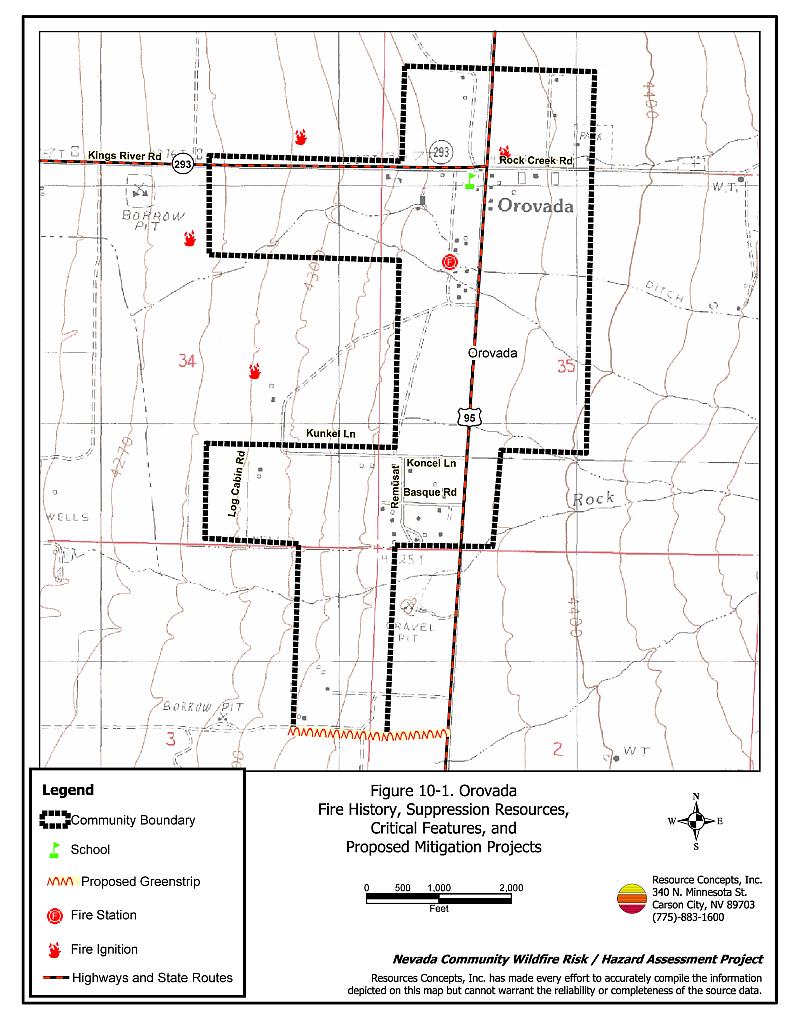
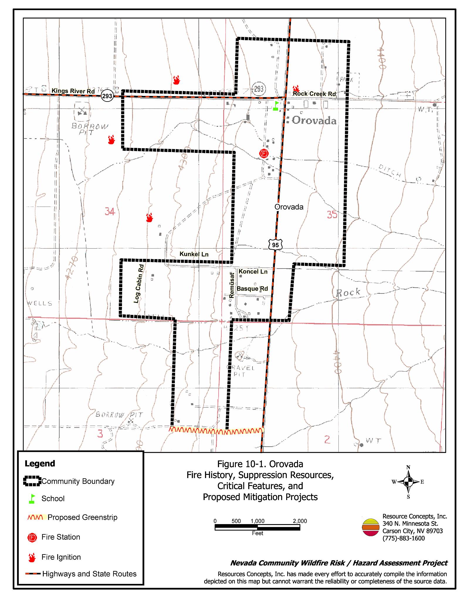
- Construct a greenstrip at least 100 feet wide on the south side of the community as shown in Figure 10-1 to reduce the fuel hazard and improve firefighter safety while defending the community and attacking the fire.
- Permit livestock grazing prior to seed maturity to reduce cheatgrass. Balance annual stocking rates with annual cheatgrass grass productivity.
10.2.3 Training and Equipment
Orovada Volunteer Fire Department
- Coordinate with the State Fire Marshall to receive structure suppression training for all volunteers.
- Coordinate with the Bureau of Land Management to maintain ongoing wildland firefighting training and work to obtain Red Card certification for all volunteers.
- Pursue grant funding and state and federal excess property programs to replace outdated fire suppression apparatus.
Bureau of Land Management Responsibilities
- Assist the Orovada Volunteer Fire Department in obtaining and administration of red card certification for wildland firefighting.
10.2.4 Public Education
Orovada Volunteer Fire Department Responsibilities
- Distribute copies of the publication Living with Fire to all property owners. This publication is free of charge and can be obtained from the University of Nevada Cooperative Extension.
- Contact the BLM Winnemucca Field Office and University of Nevada Cooperative Extension for assistance with public education.
10.3 Summary of Recommendations
| Responsible Party | Recommended Treatment | Recommendation Description |
|---|---|---|
| Property Owners | Defensible Space | Remove, reduce, and replace vegetation around homes according to the defensible space guidelines in Appendix E. |
| Humboldt County | Defensible Space | Revise codes and ordinances to require and enforce defensible space treatments on all lots in the interface area. Require provisions for fuel reduction treatment implementation and maintenance as a condition of new subdivision approval in the interface areas. |
| Fuels Reduction | Continue roadside fuel reduction treatments by mowing vegetation to a height of 4 inches within 20 feet of each side of the roads. | |
| Utility Companies | Fuels Reduction | Reduce and remove vegetation with 15 feet of poles and transformers. |
| Nevada Department of Transportation Bureau of Land Management |
Fuels Reduction | Maintain 100 foot wide greenstrips on each side of Highway-95. |
| Bureau of Land Management | Fuels Reduction | Construct and maintain a 100 foot wide greenstrip on the south side of the community (see Figure 10-1). Permit livestock grazing prior to seed maturity to reduce cheatgrass. Balance annual stocking rates with annual cheatgrass grass productivity. |
| Training and Equipment | Assist Orovada VFD volunteers in obtaining and administration of red card certification for wildland firefighting. | |
| Orovada VFD | Training and Equipment | Coordinate with the Nevada State Fire Marshal and ensure that all volunteers receive structure fire suppression training. Coordinate with BLM to maintain ongoing wildland fire training. Pursue grant funding and state federal excess property programs to replace outdated equipment |
| Public Education | Distribute copies of “Living With Fire” to property owners. Contact the BLM Winnemucca Field Office and University of Nevada Cooperative Extension for assistance with public education. |
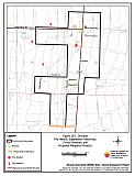
Figure 10-1Orovada Fire History, Suppression Resources, Critical Features, and Proposed Mitigation Projects |
 |
Table 10-3Orovada Wildfire Hazard Rating Summary |
 |