![]()
![]()
13.0 Quinn River
13.1 Quinn River Hazard and Risk Reduction
Quinn River is located in north-central Humboldt County along US Highway 95. The community of Quinn River is a rural ranching community composed of individual tracts of private land typically several miles apart that are interspersed with public lands. The rural ranch community type does not lend itself to the standardized community assessment procedures and is described qualitatively for defensible space, suppression resources, and fuel hazard conditions.
13.1.1 Community Design
A total of 128 residences and structures were observed in Quinn River during the assessment. Only 32 of these occurred on lot sizes smaller than ten acres.
13.1.2 Construction Materials
Nine residences were observed with flammable roofing material.
13.1.3 Defensible Space
Rural homes are generally surrounded by landscaped yards, corrals, or agricultural pastures with no wildland vegetation in close proximity to structures. These common characteristics usually contribute to a low risk of damage or direct loss of property due to wildfires. Hay and alfalfa fields, haystacks, livestock feed yards, farming equipment storage areas, and fuel tanks are assets that require special attention to defensible space for protection during a wildfire. Many of these areas would not meet the recommendations to minimize the potential for damage or loss during a wildfire.
13.1.4 Suppression Capabilities
Wildfire Protection Resources
The McDermitt and Orovada Volunteer Fire Departments provide fire protection in Quinn River. Availability of resources will depend upon time of day and possible resource allocations to in other areas at the time of the call. Table 13-1 lists wildfire suppression resources available from McDermitt and Orovada for initial attack on a wildland fire call in Quinn River.
The Denio Volunteer Fire Department also responds to fires as far south as Quinn River. A fire station at the south end of the Pueblo Fire Protection District would enable the Denio VFD to split their resources and have adequate manpower and equipment for wildfire suppression over the entire Pueblo FPD coverage area.
| Type of Equipment | Amount of Equipment | Cooperating Partner (Resource Location) |
|---|---|---|
| Engine Type 3 Engine Type 1 Engine Type 4 |
3 1 1 |
McDermitt VFD (McDermitt) |
| Engine Type 3 Engine Type 4 Engine Type 1 Water Tender |
2 1 1 2 |
Orovada VFD (Orovada) |
| Engine Type 3 | 1 | BLM (McDermitt) |
| Source: Personal communications with Chief Jess Jaca, McDermitt VFD; Chief Dave Black, Orovada VFD | ||
Bureau of Land Management wildfire suppression resources are available to all Humboldt County communities through cooperative agreements with local fire departments. The equipment listed in Table 4-2 represents resources assigned to the BLM Winnemucca Field Office that are available for dispatch within ten to fifteen minutes of notification of a wildfire. The closest available resources at the time of the dispatch would respond.
Water Sources and Infrastructure
The only sources of water for fire protection in Quinn River are wells and ranch ponds. There are no hydrants or water tanks of any notable size in the area.
Detection and Communication
The Humboldt County Sheriff’s Office notifies the Orovada and McDermitt Volunteer Fire Departments and the Central Nevada Interagency Dispatch Center of wildfires reported by 911 calls. The Central Nevada Interagency Dispatch Center dispatches both Bureau of Land Management and US Forest Service resources in Humboldt County.
Fire Protection Personnel Qualifications
All McDermitt and Orovada volunteer firefighters receive training to meet the BLM Wildland Firefighter training minimum standards. Neither VFD utilizes the Red Card system for individual qualifications. Red Card certification is part of a fire qualifications management system used by many state and all federal wildland fire management agencies that indicates an individual is qualified to fight wildfires.
Financial Support
Fire Protection Districts generally receive funding through ad valorem and other tax revenues as authorized under NRS 474.
13.1.5 Factors That Affect Fire Behavior
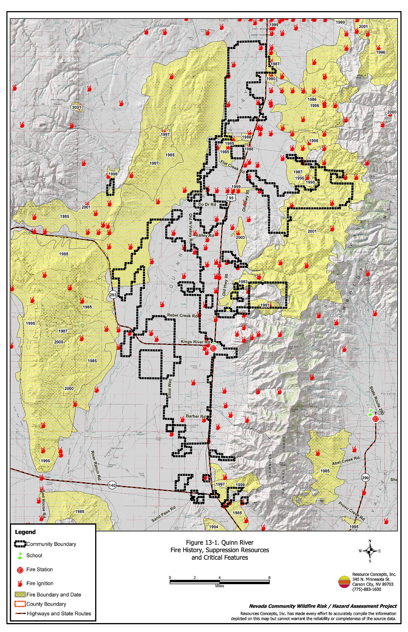
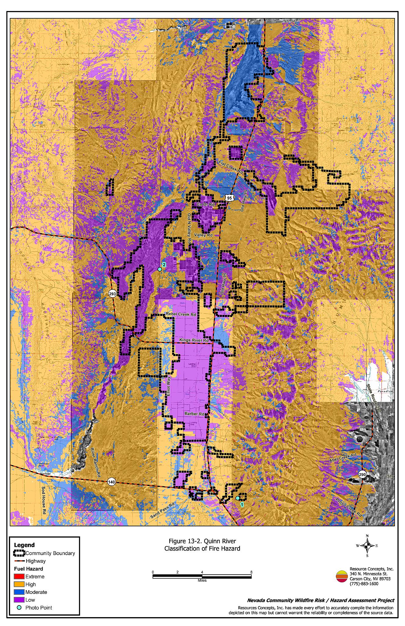
Quinn River lies in a north-south oriented valley surrounded by mountains to the east and west. The terrain is generally flat in the valley with abrupt transitions to steep mountain slopes. The predominant wind direction is from the west-southwest. Unburned shrublands in Quinn River are primarily dominated by sagebrush, or fourwing saltbush with rabbitbrush and a fine fuel component of cheatgrass or Great Basin Wildrye. The fuel load in the unburned shrublands was estimated at three to four tons per acre and was considered a moderate fuel hazard on flat terrain and a high fuel hazard on steeper slopes. Previously burned areas are dominated by cheatgrass with some rabbitbrush. The fuel load in burned areas was estimated at less than one ton per acre and was considered a low fuel hazard on flat terrain and a high fuel hazard on steeper slopes. Agricultural lands in Quinn River are irrigated and considered a low fuel hazard.
13.1.6 Worst-Case Wildfire Scenario
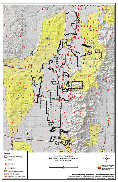
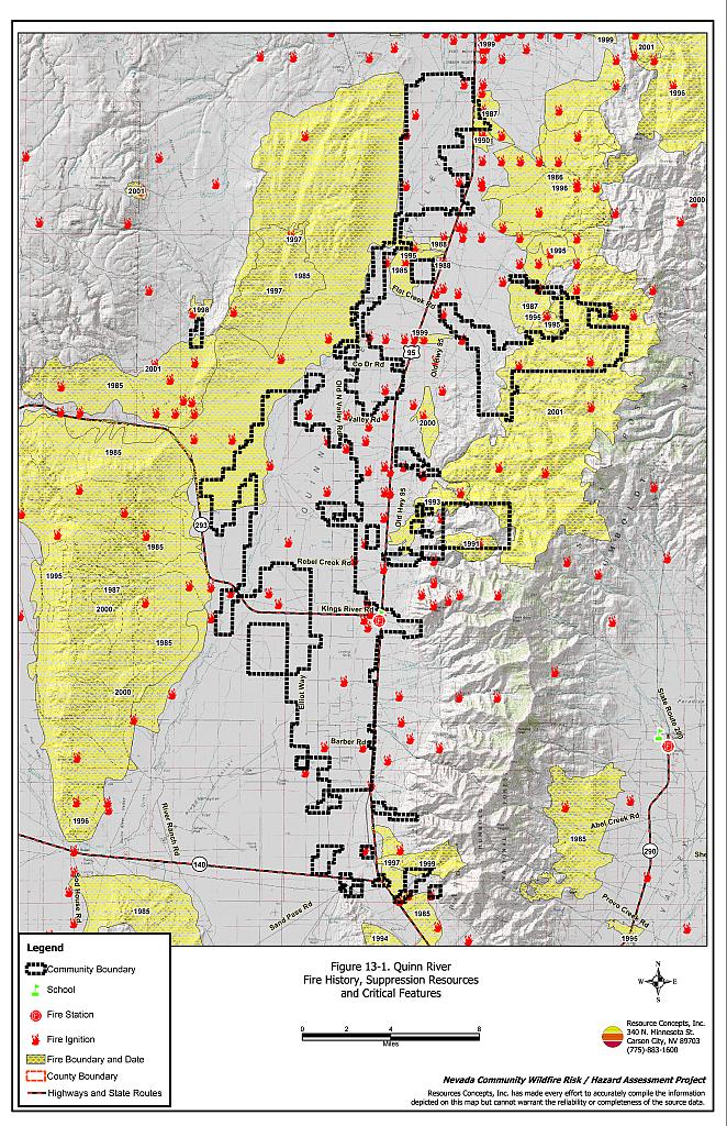
As fire history maps show, wildfires in this area can cover immense acreages before suppression crews are able to reach and contain them. The worst-case wildfire scenario in Quinn River would occur in a wet year with heavy cheatgrass production, on a windy afternoon. An ignition in the cheatgrass fuel bed would be driven by west-southwest winds through the wildland fuels. Any ranch improvements such as fences, equipment, and stockpiled commodities near wildland fuels, would be at risk of damage or loss.
13.2 Hazard Reduction Recommendations, Roles, and Responsibilities
13.2.1 Fuel Reduction Treatments
Property Owner Responsibilities
- Create a gravel firebreak for a distance of 100 feet around haystacks. Dried plant material such as stacked or baled hay is vulnerable to ignitions from internal combustion as well as from outside sources.
- Plant a fire resistant seed mixture around residential structures and ranch outbuildings. This will control cheatgrass and improve fire safety. This is especially important in these rural areas where water and suppression resources are limited and distant.
- Clear a minimum distance of ten feet around fuel tanks.
Bureau of Land Management Responsibilities
- Work cooperatively with ranchers to identify opportunities for construction of greenstrips and fuelbreaks to slow the spread of a wildfire and allow suppression resources time to arrive. Placement would take into account topography, fuels, prioritized resources, and land ownership.
- Permit livestock grazing prior to seed maturity to reduce cheatgrass. Balance annual stocking rates with annual cheatgrass grass productivity.
13.2.2 Water Supplies
Property Owner Responsibilities
- Establish backup power systems to assure functional water sources are available for fire suppression. Develop new water sources for fire protection and install hoses on existing water developments for filling water tenders.
13.2.3 Public Education
Bureau of Land Management Responsibilities
- Distribute copies of the publication Living with Fire. This publication is free of charge and copies can be requested from the University of Nevada Cooperative Extension.
- Develop a “Living with Fire” publication to address specific conditions and situations for rural ranch communities. The publication should include solutions for power back up, foaming systems, modifications to water developments for filling water tenders, fire resistant seeding recommendations, and defensible space.
13.2.4 Defensible Space
Humboldt County Responsibilities
- Revise county codes and ordinances regarding fuel reduction and defensible space for wildland-urban interface areas to:
- Require defensible space or fuel reduction treatments on all developed and undeveloped lots within interface areas. If landowners do not complete defensible space treatments or fuel reduction within an allotted time frame, the landowner should be charged for defensible space services through property tax levies.
- Require fuel reduction treatments and provisions for continued maintenance of the fuel reduction treatments as a condition of approval for new wildland-urban interface subdivisions.
13.3 Summary of Recommendations
| Responsible Party | Recommended Treatment | Recommendation Description |
|---|---|---|
| Property Owners | Fuels Reduction | Create 100 foot wide gravel firebreaks around haystacks. Plant fire resistance grasses around all structures and storage areas. Clear all vegetation with 10 feet of fuel tanks. |
| Water Supplies | Install backup power generators to power pumps during power outages Develop new water sources Install hoses on existing water improvements to fill water tenders. |
|
| Bureau of Land Management | Fuels Reduction | Cooperate with ranchers to identify, implement, and maintain greenstrips and fuelbreaks. Permit livestock grazing prior to seed maturity to reduce cheatgrass. Balance annual stocking rates with annual cheatgrass grass productivity. |
| Public Education | Distribute copies of “Living With Fire” to property owners. Develop a “Living with Fire” to address specific conditions and situations for rural ranch communities. |
|
| Humboldt County | Defensible Space | Revise codes and ordinances to require and enforce defensible space treatments on all lots in the interface area. Require provisions for fuel reduction treatment implementation and maintenance as a condition of new subdivision approval in the interface areas. |
Figure 13-1Quinn River Fire History, Suppression Resources, and Critical Features |
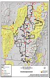 |
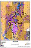
Figure 13-2Quinn River Classification of Fuel Hazard |
 |
Figure 13-3. Quinn River Fuel Hazard Photos
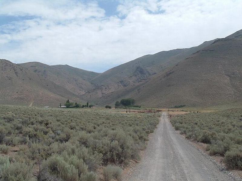
Photo Point 1. 4582076N 437782E 090°E. Shrublands in Quinn River are dominated by big sagebrush and other shrubs with a fuel load of three to four tons per acre. This condition was considered a moderate fuel hazard on flat terrain and a high fuel hazard on steep slopes.
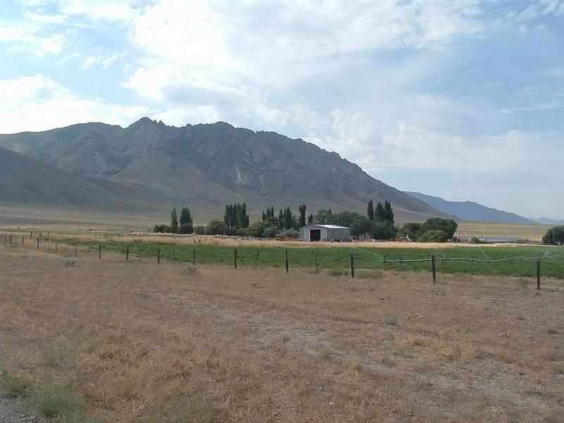
Photo Point 2. 4611977N 427611E 300°NW. Burned areas in Quinn River, dominated by cheatgrass and other annual plants, were considered a low fuel hazard on flat terrain and a high fuel hazard on steep slopes. Irrigated fields were classified as low fuel hazards and serve as fuelbreaks adjacent residences.