![]()
![]()
14.0 Valmy
14.1 Risk and Hazard Assessment
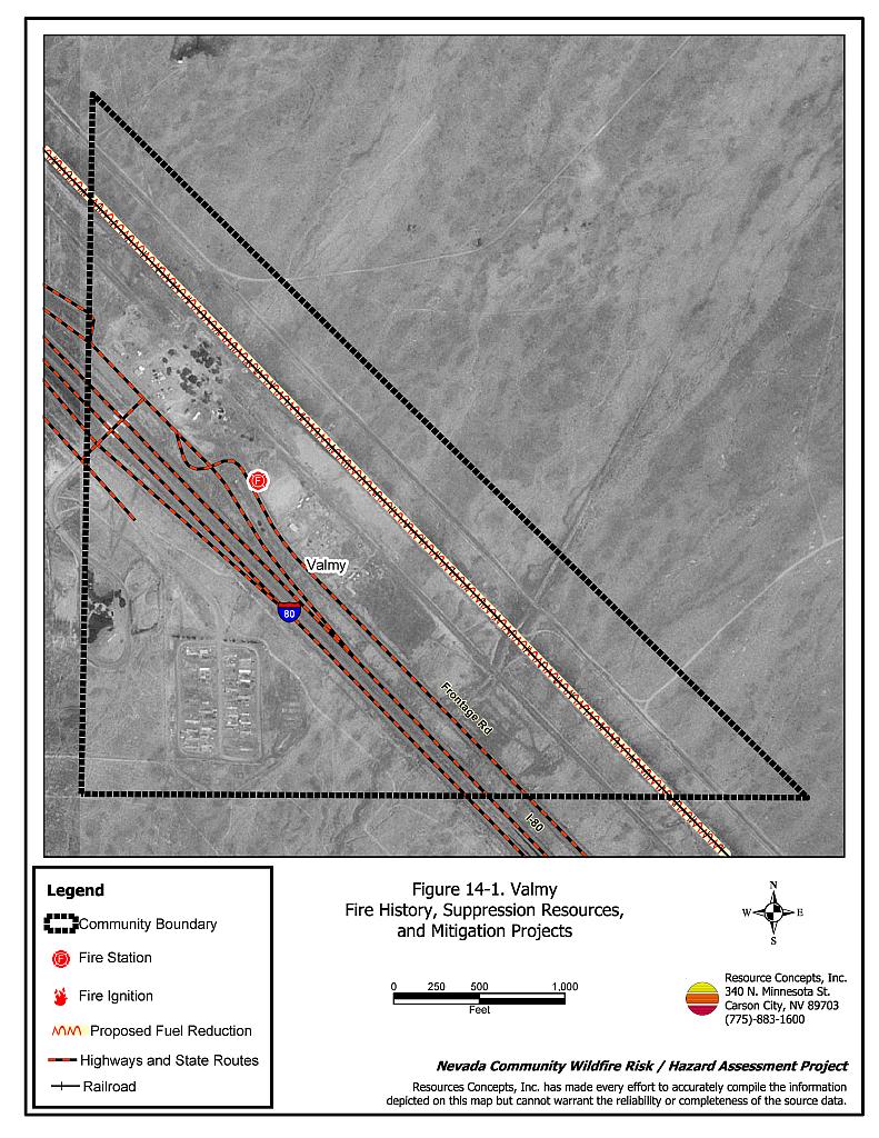
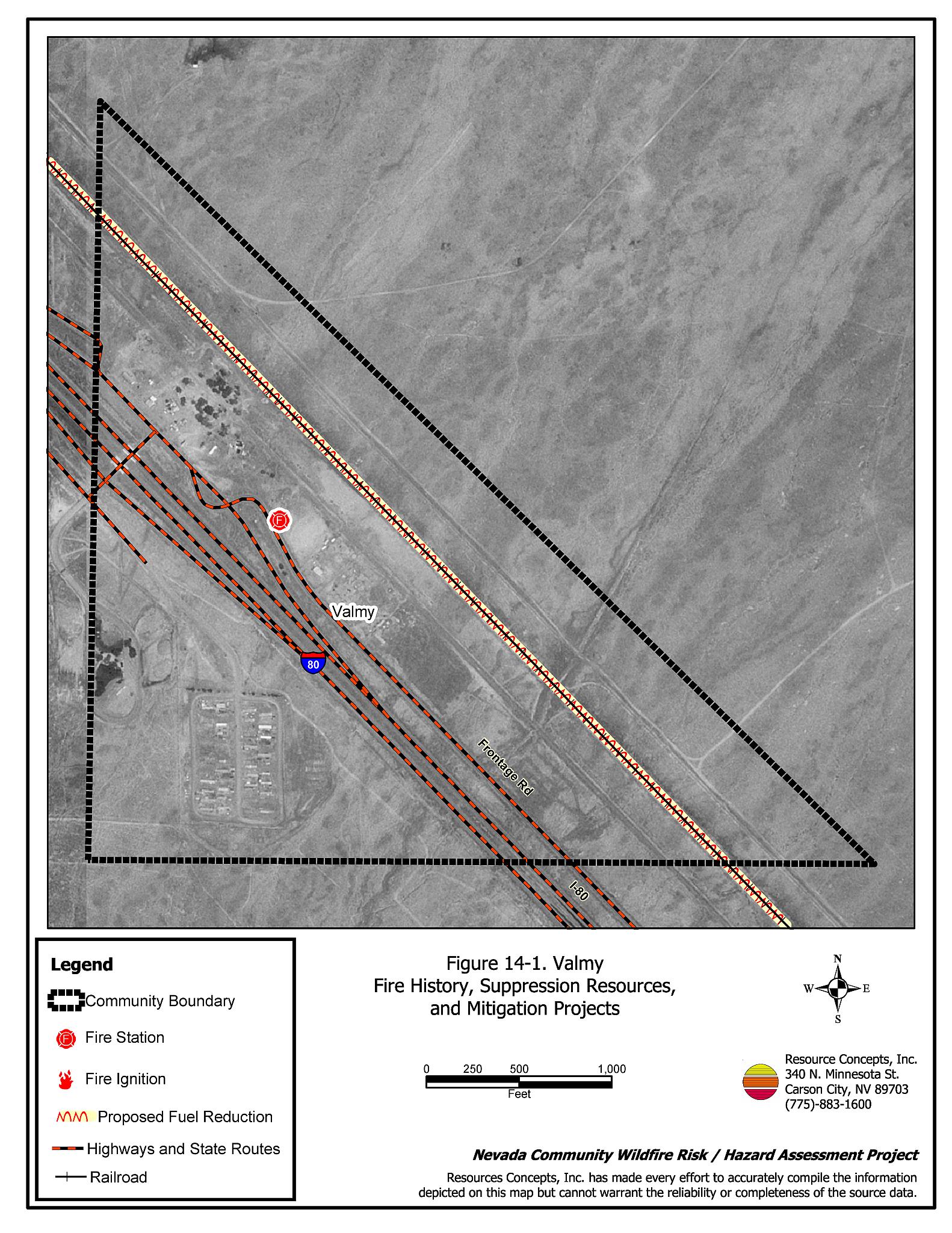
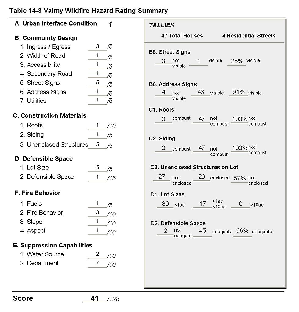
Valmy is located in southeast Humboldt County along US Interstate 80. The Union Pacific Railroad runs adjacent to I-80 and passes through the community. The community hazard assessment resulted in classifying Valmy in the Moderate Hazard category (41 points). A summary of the factors that contributed to the hazard rating is included in Table 14-3. The community hazard score for Valmy was affected by high density housing with limited visible street signs, and residential construction with a high number of hazardous architectural features.
14.1.1 Community Design
Valmy is surrounded by a classic wildland-urban interface condition. Structures abut the wildland area with a clear line of demarcation between wildland fuels and buildings. All of 47 residences observed in Valmy were on lots of less than one acre, indicating high density housing.
- Roads: US Interstate 80 is the major transportation route through the community of Valmy. The interstate is paved and wider than 24 feet. All of the roads in the community provide adequate width and gradient for two-vehicle passage or fire suppression equipment maneuverability.
- Signage: Only one street in Valmy had a posted sign that was easily visible from the road. Almost all residential addresses were easily visible from the road. Clear and visible street signs and residential addresses are important to aid firefighting personnel in locating homes during low visibility conditions that occur during a wildfire.
- Utilities: Utilities were all above ground. Many areas within power line corridors are in need of vegetation clearing and thinning.
14.1.2 Construction Materials
All of the homes in the interface were built with non-combustible or ignition resistant siding material such as medium density fiberboard (MDF), a fire-resistant material that can withstand prolonged periods of exposure to radiant heat.
All of the homes had fire resistant roofing such as composition shingles or metal. Over half of the homes observed had an unenclosed balcony, porch, deck, or other architectural features that can create drafty areas where firebrands and embers can accumulate, smolder and ignite, rapidly spreading fire to the home.
14.1.3 Defensible Space
All but two of the homes assessed had the minimum recommended defensible space to help protect the home and minimize the potential for damage or loss during a wildfire.
14.1.4 Suppression Capabilities
Wildfire Protection Resources
The community of Valmy is protected by the eleven-member Valmy Volunteer Fire Department, which is part of the Golconda Fire Protection District. Table 14-1 lists wildfire suppression resources available for initial attack on a wildland fire call in Valmy.
| Type of Equipment | Amount of Equipment | Cooperating Partner (Resource Location) |
|---|---|---|
| Engine Type 3 Engine Type 4 Water Tender |
2 1 1 |
Valmy VFD (Valmy) |
| Engine Type 6 Engine type 3 Engine Type 1 Water Tender |
2 2 1 1 |
Golconda VFD (Golconda) |
| Source: Personal communication with Chief Bill Morrison, Valmy Volunteer Fire Department. | ||
Bureau of Land Management wildfire suppression resources are available to all Humboldt County communities through cooperative agreements with local fire departments. The equipment listed in Table 4-2 represents resources assigned to the BLM Winnemucca Field Office that are available for dispatch within ten to fifteen minutes of notification of a wildfire. The closest available resources at the time of the dispatch would respond.
Water Sources and Infrastructure
Water availability for fire suppression in Valmy includes:
- Community wells,
- 500 gpm hydrants within 1,000 feet of structures, and
- Other draft sources 45 minutes or more roundtrip, at nearby mines or the Valmy Power Plant and the Humboldt River.
The water system operates on electric pumps. There is an emergency diesel backup generator to run the pumps in the event of a power failure during a wildfire.
Detection and Communication
The Humboldt County Sheriff’s Office notifies the Valmy Volunteer Fire Department and the Central Nevada Interagency Dispatch Center of wildfires reported by 911 calls. The Central Nevada Interagency Dispatch dispatches both Bureau of Land Management and US Forest Service resources in Humboldt County.
Fire Protection Personnel Qualifications
All volunteer firefighters receive training to meet the State of Nevada entry-level Firefighter qualifications and Firefighter I and II qualifications; and receive BLM Wildland Firefighter Training. The Valmy VFD utilizes the Red Card system for individual qualifications. A Red Card certification is part of a fire qualifications management system used by many state and all federal wildland fire management agencies to indicate an individual’s qualifications to fight wildfires.
Work Load
The Valmy Volunteer Fire Department responded to 28 calls in 2003:
- 4 emergency medical calls,
- 23 wildland/brush fire calls, and
- 1 structure fire.
Financial Support
Funding for the Valmy Volunteer Fire Department comes through the Golconda Fire Protection District, authorized under NRS 474. Fire Protection districts generally receive funding through ad valorem and other tax revenues.
Community Preparedness
The community of Valmy is included in Humboldt County’s Local Emergency Planning Committee hazardous materials response plan and the Humboldt County disaster plan. The Valmy VFD has a pre-attack plan that is updated every two years. The Valmy Volunteer Fire Department reviews development plans for the community, and there is currently a brush clearance program in effect that is enforced by the Valmy VFD. The Valmy VFD uses a motor grader to do roadside and other brush clearance around the community.
14.1.5 Factors Affecting Fire Behavior
The terrain in Valmy is generally flat. Predominant winds are from the west-southwest in the later afternoon. Fuels in the community interface area are sparse and consist primarily of shadscale, cheatgrass, and halogeton. There is no vertical or horizontal continuity to the fuel bed and the fuel hazard in the Valmy interface area is considered low. The fuel load was estimated at less than one ton per acre. Russian knapweed, a state-listed noxious weed, is also present.
14.1.6 Worst-Case Wildfire Scenario
The worst-case wildfire scenario for the community of Valmy would occur in a wet year with high cheatgrass production and would begin with a dry lightning ignition on the north side of Interstate 80. Erratic winds during thunderstorm events would drive a fire into the community where the biggest component of cheatgrass is located. The fire would rapidly spread into any debris or flammable material piled next to residential structures.
14.1.7 Ignition Risk Assessment
Valmy has a low ignition risk. Although there is a history of ignitions west and south of the town, there is no extensive wildfire history surrounding Valmy. The Volunteer Fire Department has conducted fuels removal and created fuelbreaks around the community. The primary ignition risk in Valmy is lightning, although human caused ignitions are unpredictable and can occur at any time.
14.2 Hazard Reduction Recommendations, Roles, and Responsibilities
The Valmy risk and hazard reduction recommendations focus on improving defensible space and promoting homeowner responsibilities. Other recommendations pertain to community coordination efforts that would enhance the fire safe nature of Valmy.
14.2.1 Defensible Space Treatments
Vegetation density, type of fuel, and slope gradient around a home affect the potential fire exposure levels to the home. The first goal of defensible space is to reduce the risk of property loss from wildfire by eliminating flammable vegetation near the home, thereby lowering the potential to burn. The second goal of defensible space is to provide firefighters a safer working area from which to defend the home or outbuildings during a wildland fire. Guidelines for improving defensible space around residences and structures are described in detail in Appendix E.
Property Owner Responsibilities
- Remove, reduce, and replace vegetation around homes according to the guidelines in Appendix E. The defensible space zone
- Lean: There are only small amounts of flammable vegetation.
- Clean: There is no accumulation of dead vegetation or other flammable debris including woodpiles.
- Green: Existing plants are healthy and green during the fire season.
- Clear all vegetation and combustible materials around propane tanks for a minimum distance of ten feet.
- Where cheatgrass or other annual grasses have become dominant within the defensible space zone, areas should be mowed prior to seed set or treated with an application of pre-emergent herbicide. Treatments may need to be repeated for several years to ensure that the bank of unwanted annual plant seeds has been depleted. Refer to Appendix E for a recommended seed mixture and planting guidelines that can be used in conjunction with cheatgrass or Russian thistle removal.
- Immediately remove cleared vegetation to an approved disposal site when implementing defensible space treatments. This material dries quickly and presents a fire hazard if left on site.
- Maintain defensible space as needed to keep the space lean, clean, and green.
- Treat areas to control Russian knapweed invasion. Refer to the Russian Knapweed Fact Sheet in Appendix E for more information regarding treatments for this noxious weed.
Humboldt County Responsibilities
- Revise county codes and ordinances regarding fuel reduction and defensible space for wildland-urban interface areas to:
- Require defensible space or fuel reduction treatments on all developed and undeveloped lots within interface areas. If landowners do not complete defensible space treatments or fuel reduction within an allotted time frame, the landowner should be charged for defensible space services through property tax levies.
- Require fuel reduction treatments and provisions for continued maintenance of the fuel reduction treatments as a condition of approval for new wildland-urban interface subdivisions.
14.2.2 Fuel Reduction Treatments
Humboldt County
- Continue treatment of areas invaded by Russian knapweed. Refer to the Russian Knapweed Fact Sheet in Appendix E for more information regarding treatments for this noxious weed.
Utility Company Responsibilities
- Reduce and remove vegetation to maintain a minimum clearance of fifteen feet around utility poles and transformers.
Union Pacific Rail Road Responsibilities
- Mow or remove vegetation within a minimum distance of fifteen feet on both sides of the railroad tracks. Maintain low density fuel volumes within the railroad corridors to reduce the wildfire ignition risk and hazard to Valmy.
Bureau of Land Management
- Permit livestock grazing prior to seed maturity to reduce cheatgrass. Balance annual stocking rates with annual cheatgrass grass productivity.
14.2.3 Community Coordination and Education
Many of the most effective activities aimed at reducing the threat of wildfire for the Valmy community require that individual property owners coordinate with each other and with local fire authorities. Public education and awareness, neighbors helping neighbors, and proactive individuals setting examples for others to follow are just some of the approaches that will be necessary to meet the fire safe goals in the community.
Valmy Volunteer Fire Department
- Distribute copies of the publication “Living with Fire” to all property owners. This publication is free of charge and copies can be requested from the University of Nevada Cooperative Extension.
- Contact the Bureau of Land Management Winnemucca Field Office and the University of Nevada Cooperative Extension for assistance with public education.
14.3 Summary of Recommendations
| Responsible Party | Recommended Treatment | Recommendation Description |
|---|---|---|
| Property Owners | Defensible Space | Remove, reduce, and replace vegetation around homes according to the defensible space guidelines in Appendix E. |
| Humboldt County | Defensible Space | Revise codes and ordinances to require and enforce defensible space treatments on all lots in the interface area. Require provisions for fuel reduction treatment implementation and maintenance as a condition of new subdivision approval in the interface areas. |
| Fuels Reduction | Continue treating Russian knapweed invasions (see Appendix E for more information). | |
| Utility Company | Fuels Reduction | Reduce and remove vegetation with 15 feet of poles and transformers. |
| Union Pacific Railroad | Fuels Reduction | Remove or mow vegetation within 15 feet of both sides of the railroad tracks. |
| Bureau of Land Management | Fuels Reduction | Permit livestock grazing prior to seed maturity to reduce cheatgrass. Balance annual stocking rates with annual cheatgrass grass productivity. |
| Valmy Volunteer Fire Department | Community Coordination and Education | Distribute copies of “Living With Fire” to property owners. Contact the BLM Winnemucca Field Office and University of Nevada Cooperative Extension for assistance with public education. |
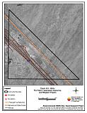
Figure 14-1Valmy Fire History and Suppression Resources |
 |
Table 14-3Valmy Wildfire Hazard Rating Summary |
 |