![]()
![]()
16.0 Fort McDermitt
16.1 Risk and Hazard Assessment
An assessment of Fort McDermitt was completed by SWCA Environmental Consultants in 2003 entitled “Wildfire Hazard Assessment and Mitigation Plan for the Primary Residential Community on the Fort McDermitt Reservation.” The following information is summarized from the SWCA report.
Fort McDermitt is an Indian reservation community located approximately two miles south of the community of McDermitt, on Highway 95. The land ownership adjacent to the community includes Fort McDermitt Indian Reservation lands, private, and public lands administered by the Bureau of Land Management. The residences are concentrated along both sides of the Quinn River drainage extending approximately six miles west of Highway 95. The SWCA assessment evaluated 124 structures and resulted in classifying the Fort McDermitt community in the High Hazard category (91 points)[2]. The high score was primarily attributed to large amounts of combustible construction materials, inadequate defensible space, and hazardous fuel loads surrounding the community.
16.1.1 Community Design
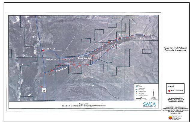
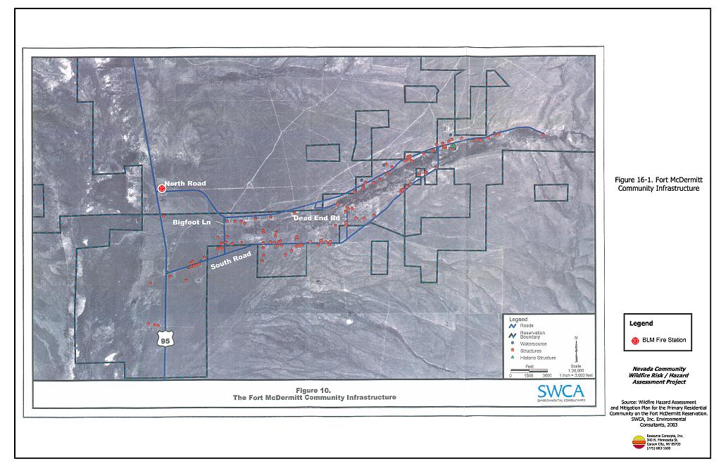
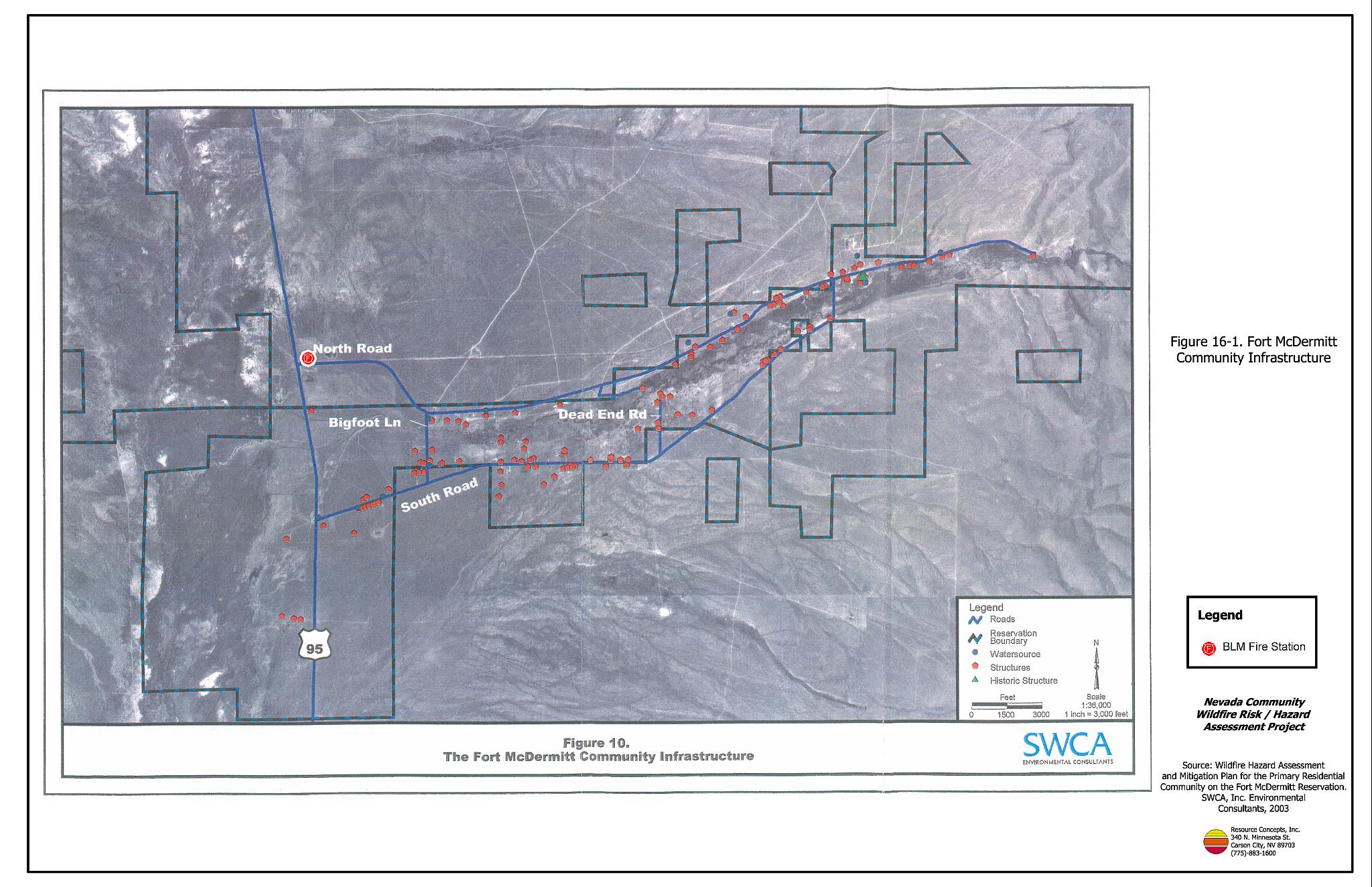
The Fort McDermitt community is characterized by an intermix wildland-urban interface condition. Structures are scattered throughout the wildland area with no clear line of demarcation between wildland fuels and residences in the community. Most structures are not spaced close together (see Figure 16-1).
- Roads: Access is limited to Highway 95 from McDermitt to the north and Winnemucca to the south. Two paved roads provide access to the community from Highway 95, North and South Reservation Roads. These roads merge approximately three miles east of the Highway. Multiple dirt roads throughout the community are unmarked.
- Signage: Residential addresses and street signs are important to aid firefighting personnel in locating homes during low visibility conditions that occur during a wildland fire. It was noted that some of the residences and roads were lacking adequate signage to be considered a firesafe community.
- Utilities: No information was provided in the SWCA report regarding the condition of the utilities.
- Historical Sites: One known historical property was identified within the community. This site is a whitewashed stone building located approximately five miles east of Highway 95 on North Reservation Road. It is a 19th century military fort. The building is currently being used as the Tribal Senior Center and is located within a cluster of administrative buildings.
16.1.2 Construction Materials
The majority of the homes in the community (78 percent) were built with class C rated wood siding, which burns in less than twenty minutes. The other homes are trailer-houses, which comprise 22 percent of the community. Most of the wood-structured homes have standard pitched roofs with wood joists. Attic spaces are vented under eves with unscreened louvered vents. All structures were recently updated to Class B roofing materials (asphalt shingles).
16.1.3 Defensible Space
Most of the structures assessed in Fort McDermitt (97 percent) did not have landscaping that would meet the minimum defensible space requirement to help protect the home from damage or loss during a wildfire.
16.1.4 Suppression Capabilities
There was no local fire department in Fort McDermitt at the time of the assessment, and no agreements with the McDermitt Volunteer Fire Department or the Bureau of Land Management to provide emergency response for structure fires. Although there are no formal cooperative agreements, BLM and McDermitt VFD have responded to various fires on the reservation in the past. Wildland fire protection is also limited on the reservation. The BLM McDermitt fire station is located in the community of McDermitt and is staffed on a year round basis. Additional wildland fire suppression resources within the general area are listed in Table 16-1. Additional resources from the BLM Winnemucca Field Office are summarized in Table 4-2 and, when available, are stationed 70 miles south of the community.
| Type of Equipment | Amount of Equipment | Cooperating Partner (Resource Location) |
|---|---|---|
| Type IV Engine* Fire Operations Supervisor* |
3 1 |
BLM Fire Station (McDermitt)* |
| Fire Specialist Type IV Engine Light Engine/Patrol Vehicle |
2 1 1 |
USFS Fire Station (Paradise Valley) |
| Sources: Personal Communication with Jeff Fedrizzi, BLM Winnemucca Fire Management Officer and Wildfire Hazard Assessment and Mitigation Plan for the Primary Residential Community on the Fort McDermitt Reservation (SWCA 2003). | ||
Water Sources and Infrastructure
Water availability for fire suppression in Fort McDermitt includes a hydrant system, but the current condition is believed to be in disrepair.
16.1.5 Factors Affecting Fire Behavior
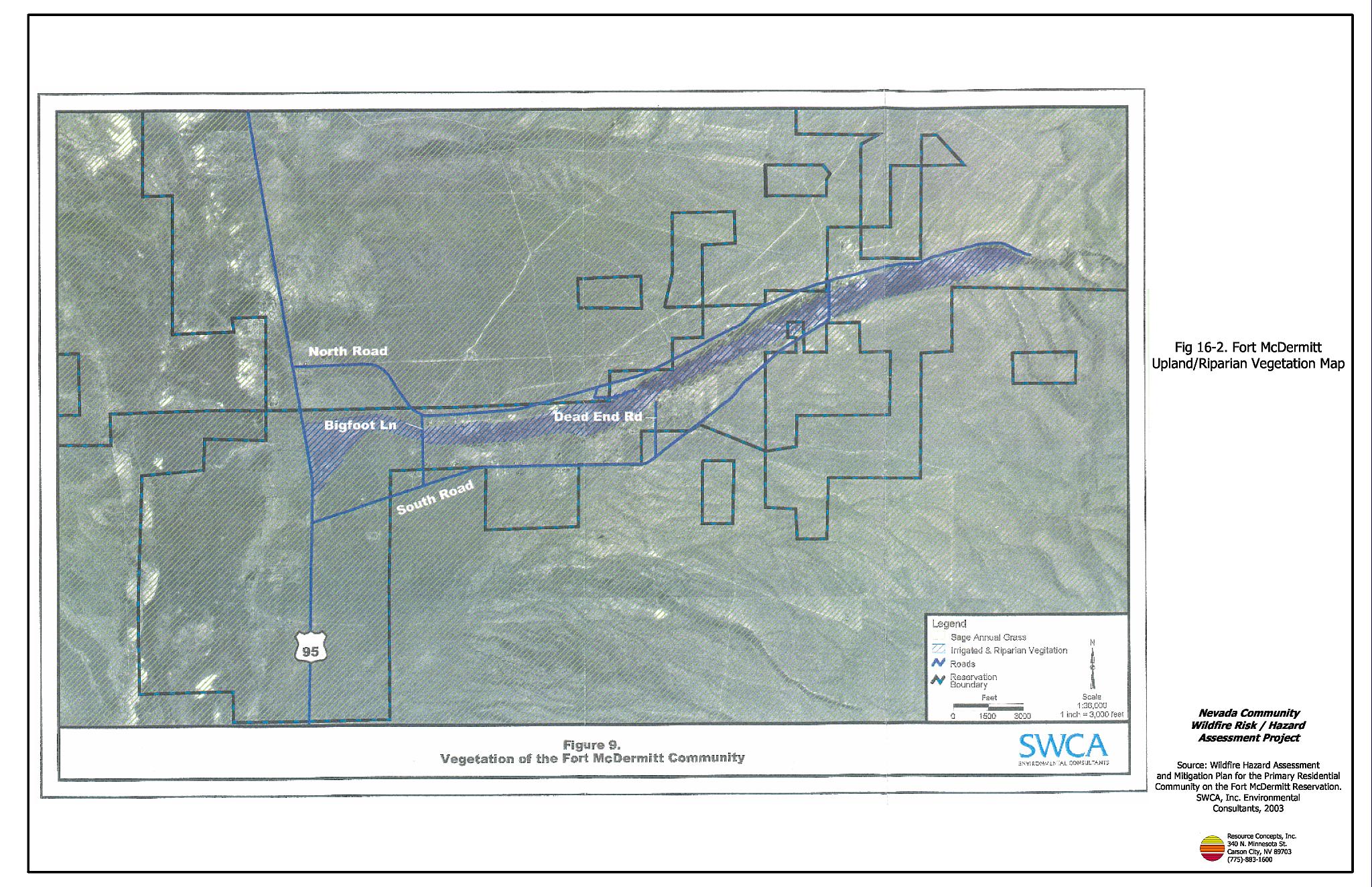
The terrain around Fort McDermitt is primarily flat. Vegetation, dead and down fuels, weather, and topography contribute to the potential fire hazard in the wildland-urban interface. The fuel hazards were mapped for Fort McDermitt and are included in Figure 16-2. The majority of the fuels around Fort McDermitt are brush types consisting of sagebrush, rabbitbrush, shadscale, cheatgrass, Indian ricegrass, needlegrass, and Sandberg bluegrass. The average vegetation ranges in height from one to three feet. The total fuel load is approximately four tons per acre and was considered a high hazard. Riparian vegetation along the Quinn River bottom and irrigated areas within close proximity to the community consist of saltbrush, cottonwood, willows, sedges, and pasture grass. These areas are generally irrigated throughout the summer months and were considered a low fuel hazard. The prevailing winds blow west to east, and generally increase later in the day. Summer temperatures, dry conditions, and afternoon winds can contribute greatly to ignition and wildfire risk within and around the community.
16.1.6 Fire Behavior and Worst Case Scenario
The RCI Project Team assessment of the worst-case scenario for the Fort McDermitt community would begin with a dry lightning ignition near the west end of the community on a high hazard day or from human activity near Highway 95. Wind gusts of 25 mph or greater from the southwest would drive the fire eastward along each side of the Quinn River into the homes, intermixed with the dense fuels. The scenario would be worsened if the BLM fire suppression resources from McDermitt were unavailable due to assignment to an emergency situation elsewhere. This worst case wildfire scenario would also be exacerbated in years with above average precipitation levels and increased grass production.
16.1.7 Ignition Risk Assessment
An extensive history of wildfires and ignitions has been recorded in and around the Fort McDermitt community. Fort McDermitt generally has an average of one structure fire, and six wildland fires per year. High ignition rates are likely due to the high fuel loads and human activities.
16.2 Risk and Hazard Reduction Recommendations, Roles, and Responsibilities
The Fort McDermitt risk and hazard reduction recommendations focus on improving defensible space and promoting homeowner responsibilities. Other recommendations pertain to community coordination efforts that could be initiated to enhance the fire safe nature of the Fort McDermitt community. SWCA (2003) recommendations are summarized below.
16.2.1 Defensible Space
Vegetation density, type of fuel, and slope gradient around a home affect the potential fire exposure levels to the home. The first goal of defensible space is to reduce the risk of property loss from wildfire by eliminating flammable vegetation near the home, thereby lowering the potential to burn. The second goal of defensible space is to provide firefighters a safer working area from which to defend the home or outbuildings during a wildland fire.
Property Owner Responsibilities
- Increase and implement defensible space around all structures to a minimum of 70 feet of clearance (SWCA 2003).
16.2.2 Fire Suppression Capabilities
Property Owner Responsibilities
- Clearly mark all residences with the appropriate address or house number.
Fort McDermitt Tribal Responsibilities
- Clearly identify all streets with signs having reflective lettering four inches in height.
- Make sure that street signs are clearly visible by emergency response vehicles and evacuees.
- Maintain and service the existing hydrant system. All hydrants should be serviced and maintained by greasing, painting, flow testing, and replacing them if they are unserviceable or nonfunctional.
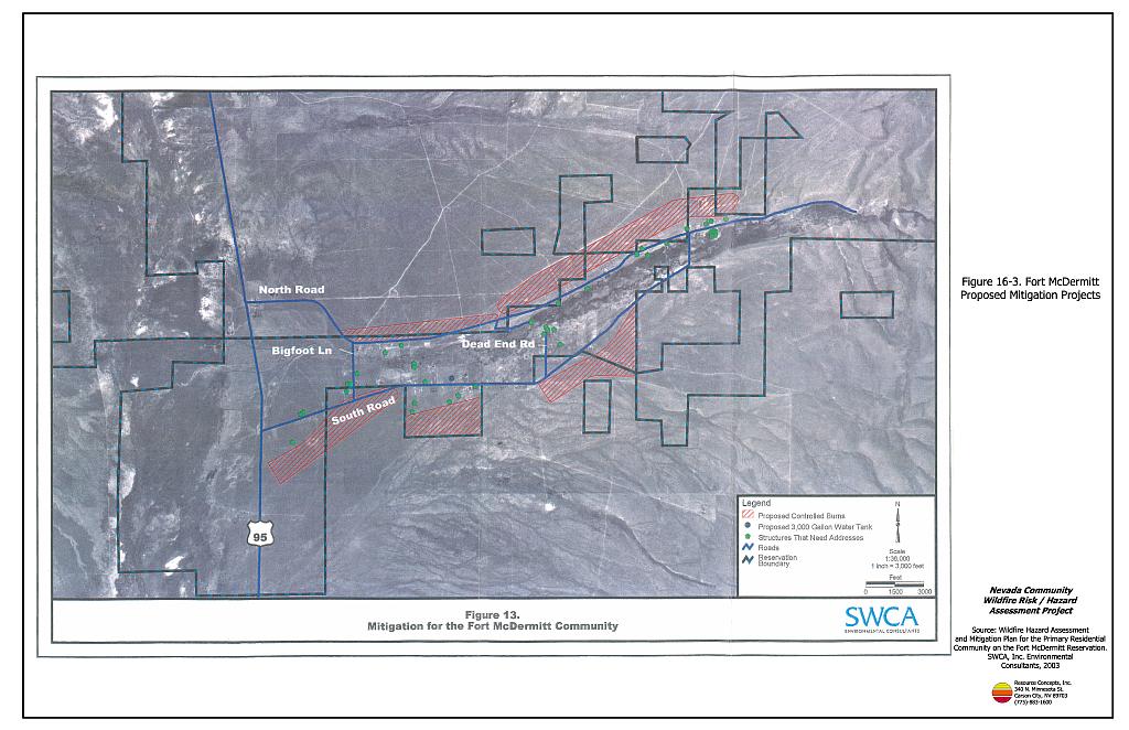
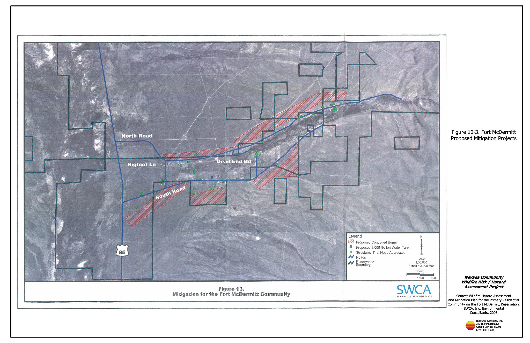
- One 3,000-gallon water storage tank should be installed in the central part of the community on South Reservation Road. This tank will provide local drafting sites for community areas where the hydrants have less than adequate spacing for community protection (see Figure 16-3).
- Develop a memorandum of agreement with another agency or volunteer fire department to provide structural fire suppression and protection for the community of Fort McDermitt.
16.2.3 Fuel Reduction Treatments
Fuels reduction treatments are aimed at reducing the risk of a catastrophic wildland fire from entering the community in an uncontrollable manner. Heavy fuel loads always present a risk to the community, and should be manipulated where possible in manner that reduces the risk to the community.
Tribe Responsibilities
Conduct a prescribed burn located along the northern and southern portions of the community to reduce high fuel loads as shown on Figure 16-3.
- Burn a total of 976 acres to reduce fuels and create a firebreak along the northern and southern portions of the community.
- Implement prescribed burns in the late fall after livestock removal from the range and optimal weather conditions occur for prescribed burning and safety.
- Reseed identified areas with native seed mix of grasses to create a mosaic that is grass dominated.
16.2.4 Community Coordination and Education
Tribe Responsibilities
- Increase individual awareness of wildfire issues through community newsletters, publications, meetings, and workshops.
- Encourage the community residents to be proactive, especially in implementing defensible space and improving home address visibility.
16.3 Summary of Recommendations
| Responsible Party | Recommended Treatment | Recommendation Description (SWCA 2003) |
|---|---|---|
| Property Owners | Defensible Space | Increase defensible space to at least 70 feet. |
| Community Coordination | Improve address visibility. Participate in public education opportunities and become knowledgeable of emergency evacuation procedures. |
|
| Fort McDermitt Tribe | Fuels Reduction | Implement prescribed burns to reduce fuel loads. |
| Fire Suppression Capabilities | Install 3,000 gallon water storage tank. Maintain and service the fire hydrant system. Place adequately visible signage on all streets. Develop memorandum of agreement or some other means to establish structural fire suppression services. |
|
| Community Coordination | Increase individual awareness of wildfire issues through community newsletters, publications, meetings, and workshops. Encourage community residents to be proactive, especially in establishing and promoting defensible space and improving home address visibility. |
Figure 16-1Fort McDermitt Community Infrastructure |
 |
Figure 16-2Fort McDermitt Upland/Riparian Vegetation Map |
 |
Figure 16-3Fort McDermitt Proposed Mitigation Projects |
 |