![]()
![]()
15.0 Winnemucca
15.1 Risk and Hazard Assessment
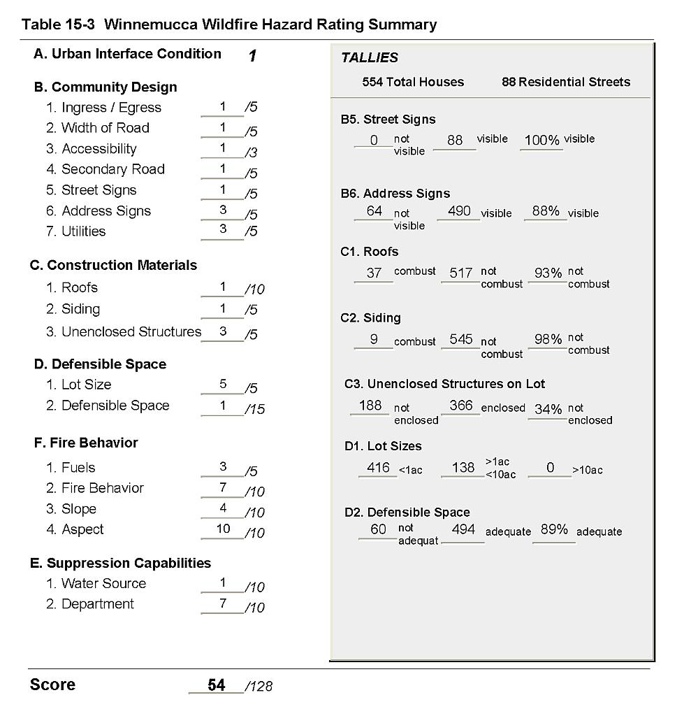
Winnemucca is located in southeast Humboldt County along US Interstate 80 and US Highway 95. The Union Pacific Railroad passes through town. The hazard assessment of 554 residences in the interface area resulted in classifying Winnemucca in the Moderate Hazard category (54 points). A summary of the factors that contributed to the hazard rating is included in Table 15-3. The factors that most influenced the hazard rating for Winnemucca were a high density of structures in the wildland-urban interface area, heavy fuels accumulations throughout the community, and less than adequate defensible space around numerous homes in the interface area.
15.1.1 Community Design
The wildland-urban interface area surrounding Winnemucca is a classic interface condition. There is a clear line of demarcation between wildland fuels and residential structures. Nearly all of the homes assessed were on lots of less than one acre.
- Roads: US Interstate 80 and US Alt. 95 are the major transportation routes through Winnemucca. These highways are paved and are wider than 24 feet. All of the community roads are of adequate width and gradient to allow for two-way vehicle passage and for fire suppression equipment maneuverability.
- Signage: All residential streets signs were easily visible from the road. Addresses were easily visible from the road on about 88 percent of the homes. Clear and visible street signs and residential addresses are important to aid firefighting personnel in locating homes during low visibility conditions that occur during a wildfire.
- Utilities: Utilities were all above ground and have been properly maintained.
15.1.2 Construction Materials
Ninety eight percent of the homes in the interface were built with non-combustible or ignition resistant siding materials. Many of the homes had siding made of medium density fiberboard (MDF), a material that typically burns only when exposed to high temperatures for a prolonged period of time.
Nearly all of the homes had fire resistant roofing such as composition shingles or metal roofs. Approximately one-third of the homes observed had an unenclosed balcony, porch, deck or other architectural features that can create drafty areas where firebrands and embers can accumulate, smolder and ignite, rapidly spreading fire to the home.
15.1.3 Defensible Space
Sixty of the homes assessed did not have the minimum requirements recommended for defensible space to help protect the home or minimize the potential for damage or loss during a wildfire.
15.1.4 Suppression Capabilities
Wildfire Protection Resources
The Winnemucca Volunteer Fire Department protects the community of Winnemucca. At the time that interviews were conducted for this report, the Winnemucca VFD had 24 volunteer members. Table 15-1 lists wildfire suppression resources available for initial attack on a wildland fire call in Winnemucca.
| Type of Equipment | Amount of Equipment | Cooperating Partner (Resource Location) |
|---|---|---|
| Engine Type 6 Engine Type 3 |
2 1 |
Winnemucca VFD |
| Source: Personal communication with Chief Walt Johnston, Winnemucca Volunteer Fire Department. | ||
Bureau of Land Management wildfire suppression resources are available to all Humboldt County communities through cooperative agreements with local fire departments. The equipment listed in Table 4-2 represents resources assigned to the BLM Winnemucca Field Office that are available for dispatch within ten to fifteen minutes of notification of a wildfire.
The Nevada Division of Forestry Honor Camp at Rose Creek, approximately 5 miles west of Winnemucca, has trained fire crews that are available for fuel reduction and fire suppression activities.
Water Sources and Infrastructure
Water availability for fire suppression in Winnemucca includes:
- Community well,
- 500 gpm hydrants within 500 feet of structures,
- Water storage tanks, and the
- The Humboldt River.
The community water system operates on gravity and electrical pumps. There is a backup emergency generator to run the pumps in the event of a power failure during a wildfire.
Detection and Communication
The Humboldt County Sheriff’s Office notifies the Winnemucca Volunteer Fire Department and the Central Nevada Interagency Dispatch Center of wildfires reported by 911 calls. The Central Nevada Interagency Dispatch dispatches both Bureau of Land Management and US Forest Service resources in Humboldt County.
Fire Protection Personnel Qualifications
All volunteer firefighters are trained to meet the State of Nevada entry-level Firefighter and Firefighter I and II qualifications; and receive BLM Wildland Firefighter training. The Winnemucca VFD does not utilize the Red Card system for individual qualifications. A Red Card certification is part of a fire qualifications management system used by many state and all federal wildland fire management agencies to indicate an individual’s qualifications to fight wildfires.
Work Load
The Winnemucca Volunteer Fire Department responded to eight calls in 2003:
- Two wildland/brush fire calls, and
- Six hazardous material spills.
The Winnemucca Volunteer Fire Department does not respond to emergency medical calls.
Financial Support
Funding for the Winnemucca Volunteer Fire Department comes from the Winnemucca General Fund.
Community Preparedness
The community of Winnemucca is included in Humboldt County’s Local Emergency Planning Committee, which includes hazardous materials response, and the Humboldt County disaster plan. The Humboldt County Sheriff’s Office manages the County emergency evacuation plan, and the Winnemucca Volunteer Fire Department manages the pre-attack plan. The Winnemucca VFD reviews development plans for the community. There is currently no brush clearance program in Winnemucca.
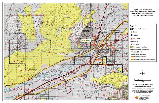
The Winnemucca BLM Field Office constructed a 300-foot wide greenstrip on the east side of Winnemucca in 2001 to help reduce the risk of wildfire threatening the east side of the community. The BLM seeded the greenstrip with forage kochia, a fire-resistant and low growing perennial forb (M. Whalen, pers. comm.). The total project length was approximately 1.75 miles.
15.1.5 Factors Affecting Fire Behavior
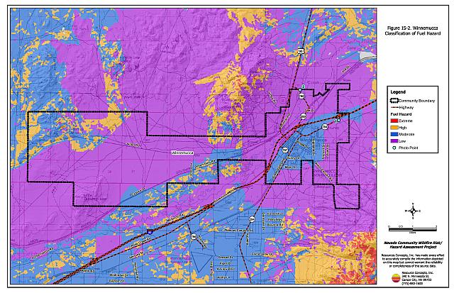
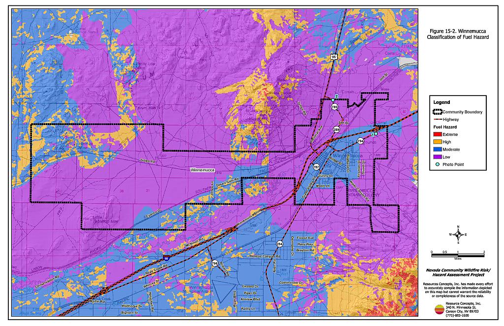
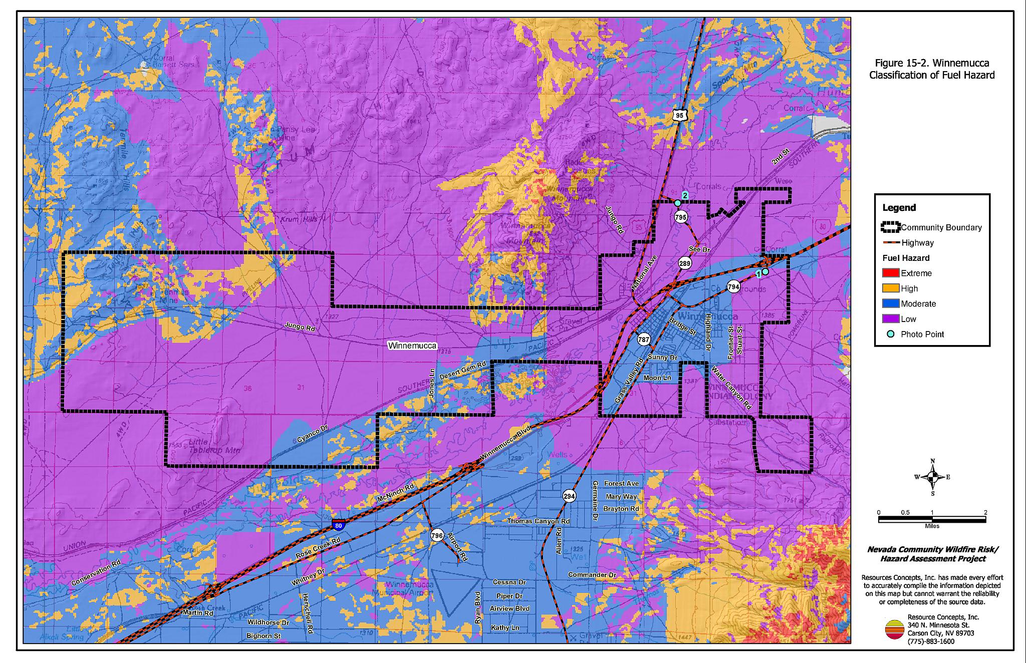
Slopes in and around the community vary from flat to twenty percent with a south aspect. Narrow mountain canyons occur directly west of the community. The predominant wind directions are from the west-southwest, although during summer thunderstorms erratic winds can come from any direction. A large part of the interface area around Winnemucca has burned repeatedly since 1985. The burned areas were reseeded and are composed of some crested wheatgrass, Sandberg bluegrass, bottlebrush squirreltail and cheatgrass. The overall fuel hazard in the burn areas of the interface was considered low. Unburned shrublands consist primarily of sagebrush, fourwing saltbush, rabbitbrush, or greasewood with squirreltail and cheatgrass ground fuels. These areas were estimated at two to four tons per acre, and considered a moderate fuel hazard on flat terrain and a high fuel hazard on steeper slopes. The fuel load along the Humboldt River was estimated at six to eight tons per acre consisting primarily of Russian olive, elms, willow, and poplar trees, with cattails and some cheatgrass.
15.1.6 Worst-Case Wildfire Scenario
The worst-case scenario for the community of Winnemucca would begin with a lightning ignition in the shrub fuel type in or around the community. Erratic winds would drive the fire through cheatgrass and into the shrub layer, with flame lengths up to fifteen feet in height and moving at a rate of approximately 1,900 to 5,300 feet per hour. This rapidly moving fire could exceed initial attack resources and spread to structures in the community.
15.1.7 Ignition Risk Assessment
The ignition risk in Winnemucca is high based on historic ignition patterns and wildfire history. The primary ignition risks in Winnemucca are lightning and ignitions from highway or railroad accidents, although human caused ignitions are unpredictable and can occur at any time.
15.2 Hazard Reduction Recommendations, Roles, and Responsibilities
The Winnemucca risk and hazard reduction recommendations focus on improving defensible space and implementing fuel reduction projects around the community. Other recommendations pertain to community coordination efforts that would enhance the fire safe nature of Winnemucca.
15.2.1 Defensible Space Treatments
Vegetation density, type of fuel, and slope gradient around a home affect the potential fire exposure levels to the home. The first goal of defensible space is to reduce the risk of property loss from wildfire by eliminating flammable vegetation near the home, thereby lowering the potential to burn. The second goal of defensible space is to provide firefighters a safer working area from which to defend the home or outbuildings during a wildland fire. Guidelines for improving defensible space around residences and structures are described in detail in Appendix E.
Property Owner Responsibilities
- Remove, reduce, and replace vegetation around homes according to the guidelines in Appendix E. The defensible space zone
- Lean: There are only small amounts of flammable vegetation.
- Clean: There is no accumulation of dead vegetation or other flammable debris including woodpiles.
- Green: Existing plants are healthy and green during the fire season.
- Clear all vegetation and combustible materials around propane tanks for a minimum distance of ten feet.
- Maintain the area beneath unenclosed wood decks and porches free of weeds and flammable debris. Screen these areas wherever possible.
- Mow or remove brush growing against wood fences in the community.
- Establish and maintain defensible space around stockpiled hay, livestock corrals, equipment storage areas, and outbuildings.
- Where cheatgrass or other annual grasses have become dominant within the defensible space zone, areas should be mowed prior to seed set or treated with an application of pre-emergent herbicide. Treatments may need to be repeated for several years to ensure that the bank of unwanted annual plant seeds has been depleted. Refer to Appendix E for a recommended seed mixture and planting guidelines that can be used in conjunction with cheatgrass or Russian thistle removal.
- Immediately remove cleared vegetation to an approved disposal site when implementing defensible space treatments. This material dries quickly and presents a fire hazard if left on site.
- Maintain defensible space as needed to keep the area lean, clean, and green.
Humboldt County Responsibilities
- Revise county codes and ordinances regarding fuel reduction and defensible space for wildland-urban interface areas to:
- Require defensible space or fuel reduction treatments on all developed and undeveloped lots within interface areas. If landowners do not complete defensible space treatments or fuel reduction within an allotted time frame, the landowner should be charged for defensible space services through property tax levies.
- Require fuel reduction treatments and provisions for continued maintenance of the fuel reduction treatments as a condition of approval for new wildland-urban interface subdivisions.
15.2.2 Fuels Reduction Treatments
Bureau of Land Management and Humboldt County Responsibilities
- Construct greenstrips around the community 100 to 200 feet wide on the northwest, south, and northeast portions of the community as shown in Figure 15-1. The proposed greenstrip treatment area is approximately 80 to 170 acres in size, however the treatment areas should be located on a site specific basis before construction begins. The purpose of the greenstrip treatments is to reduce the fuel hazard and improve firefighter safety while defending the community.
- Seed the greenstrip treatment areas with low-growing, fire-resistant perennial grasses and forbs. Where possible on private lands, incorporate use of pre-emergent herbicides to help prevent cheatgrass germination.
- Permit livestock grazing prior to seed maturity to reduce cheatgrass. Balance annual stocking rates with annual cheatgrass grass productivity.
Union Pacific Railroad Responsibilities
- Mow or remove vegetation within a minimum distance of fifteen feet on both sides of the railroad tracks. Maintain low density and reduced fuel volumes within the railroad corridors to reduce the wildfire ignition risk and hazard to Winnemucca.
15.2.3 Community Coordination and Education
Many of the most effective activities aimed at reducing the threat of wildfire for the Winnemucca community require that individual property owners coordinate with each other and with local fire authorities. Public education and awareness, neighbors helping neighbors, and proactive individuals setting examples for others to follow are just some of the approaches that will be necessary to meet the fire safe goals in the community.
Property Owner Responsibility
- Form a local chapter of the Nevada Fire Safe Council. The Nevada Fire Safe Council facilitates solutions to reduce the loss of lives and property from wildfire in Nevada’s communities. Through the establishment of a local Chapter, local communities will become part of a large network for sharing information, including notification of programs and funding opportunities for fire mitigation projects such as those listed in this report. The Nevada Fire Safe Council will accept and manage grants and contracts on the Chapter’s behalf through its non-profit status. The Nevada Fire Safe Council will provide assistance and support to communities to complete fire safe plans, set priorities, educate and train community members and promote success stories of its members. To form a local Chapter or for more information contact the:
Nevada Fire Safe Council
1187 Charles Drive
Reno, Nevada 89509
(775) 322-2413
www.nvfsc.org
Winnemucca Volunteer Fire Department
- Distribute copies of the publication “Living with Fire” to all property owners. This publication is free of charge and copies can be requested from the University of Nevada Cooperative Extension.
- Contact the Bureau of Land Management Winnemucca Field Office and the University of Nevada Cooperative Extension for assistance with public education.
15.3 Summary of Recommendations
| Responsible Party | Recommended Treatment | Recommendation Description |
|---|---|---|
| Property Owners | Defensible Space | Remove, reduce, and replace vegetation around homes according to the defensible space guidelines in Appendix E. |
| Community Coordination and Education | Form a local chapter of the Nevada Fire Safe Council. | |
| Humboldt County | Defensible Space | Revise codes and ordinances to require and enforce defensible space treatments on all lots in the interface area. Require provisions for fuel reduction treatment implementation and maintenance as a condition of new subdivision approval in the interface areas. |
| Bureau of Land Management Humboldt County |
Fuels Reduction | Construct greenstrips around the community 100 to 200 feet wide on the northwest, south, and northeast portions of the community as shown in Figure 15-1. Seed the greenstrip treatment areas with low-growing, fire-resistant perennial grasses and forbs. Permit livestock grazing prior to seed maturity to reduce cheatgrass. Balance annual stocking rates with annual cheatgrass grass productivity. |
| Union Pacific Railroad | Fuels Reduction | Remove or mow vegetation on both sides of the tracks within 15 feet. |
| Winnemucca Volunteer Fire Department | Community Coordination and Education | Distribute copies of “Living With Fire” to property owners. Contact the BLM Winnemucca Field Office and University of Nevada Cooperative Extension for assistance with public education. |
Figure 15-1Winnemucca Fire History, Suppression Resources, Critical Features, and Existing and Proposed Mitigation Projects |
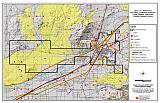 |
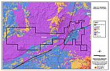
Figure 15-2Winnemucca Classification of Fuel Hazards |
 |
Figure 15-3. Winnemucca Fuel Hazard Photos
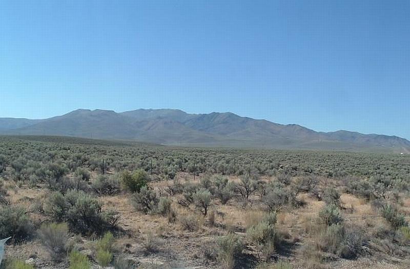
Photo Point 1. 4537305N, 441588E, 150°SE. Shrublands dominated by sagebrush and rabbitbrush with a fine fuel component of cheatgrass were considered a moderate fuel hazard.
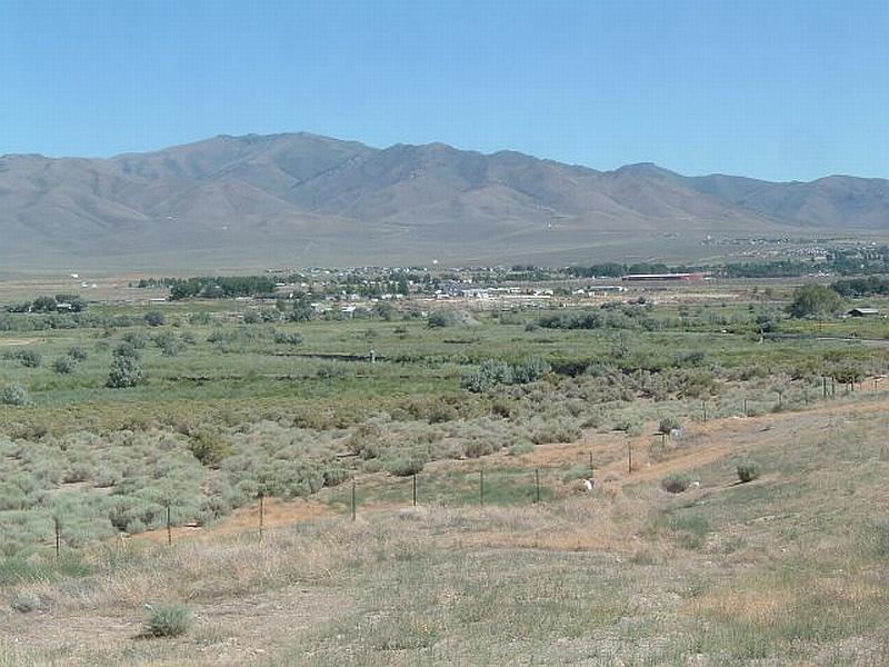
Photo Point 2. 4539367N, 438953E, 174° SE. The fuels along the Humboldt River corridor include Russian olive, tamarisk, willow, rabbitbrush, wild rose, and salt grass. Fuel loading here was estimated at six to eight tons per acre.
Table 15-3Winnemucca Wildfire Hazard Rating Summary |
 |