![]()
![]()
10.0 Mt. Wilson
10.1 Risk and Hazard Assessment
In 2002, Resource Concepts, Inc. completed an assessment entitled Community Wildfire Risk Assessment and Fuel Reduction Plan for the Mt. Wilson Guest Ranch Community in Lincoln County, Nevada on behalf of Lincoln County. The pertinent information from this report is summarized from the RCI Mt. Wilson assessment.
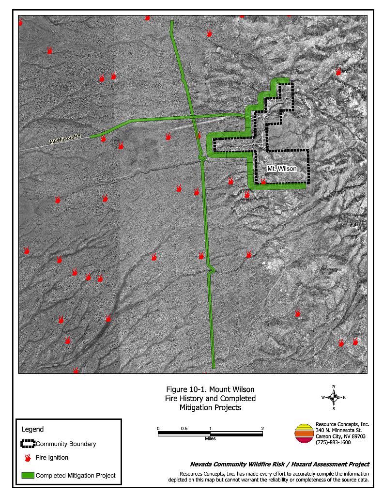
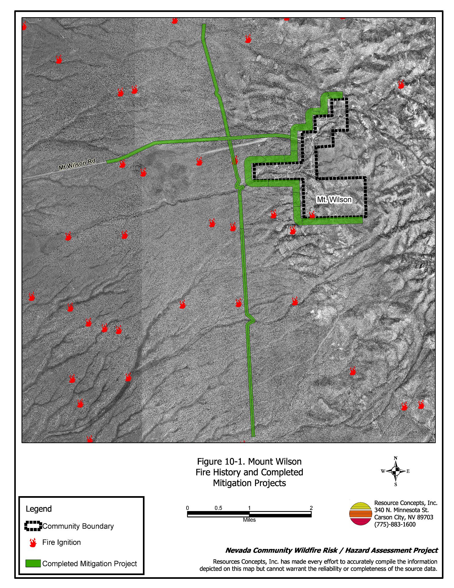
The Mt. Wilson community is located in west-central Lincoln County on U.S. Highway 93, about 25 miles north of Pioche and 85 miles south of Ely. The community is situated about nine miles from Highway 93 on Mt. Wilson Guest Ranch Road. The risk/hazard assessment resulted in classifying the Mt. Wilson community in the Extreme Hazard category. The extreme rating was attributed to inadequate defensible space; areas of extreme fuel hazard pinyon-juniper vegetation; narrow, steep, and winding roads; and the absence of a local fire department or water sources for fire suppression. Even though several large-scale fuel reduction treatments have been completed in the community, it is still at high risk because of inadequate implementation of defensible space. Figures 10-1 and 10-2 illustrate the location of the community and previously completed fuel reduction treatments.
10.1.1 Community Design
The wildland-urban interface area around Mt. Wilson is characterized as an intermix interface condition. There is no clear line of demarcation between structures and wildland fuels. Approximately fifty homes were included in the assessment. All were on parcels of five acres or greater.
- Access: U.S. Highway 93 is the major transportation route to the Mt. Wilson Guest Ranch Road and the Mt. Wilson community. The highway is at least 24 feet wide, paved and has adequate turnaround space for fire suppression equipment. The Mt. Wilson Guest Ranch Road is greater than 24 feet wide and is clear of roadside vegetation. All other secondary roads in the community are steep and narrow, with dense adjacent vegetation. None of the roads within the community have adequate turn-around space for fire suppression equipment maneuverability or two-vehicle passage for evacuation in the event of a wildfire.
- Signage: Some of the community streets have recently posted street signs. In most cases addresses could not be seen clearly on any of the homes.
- Utilities: All of the utilities are above ground. Many of the power line corridors have not been properly maintained to minimize wildfire damage to electric utilities and reduce the possibility that sparks created by arcing power lines could start a fire in adjacent vegetation.
10.1.2 Construction Materials
Ninety-four percent of the homes observed in the interface area were built with non-combustible roofing, such as metal, composition, or tile. Siding materials were not assessed. Seventy percent of the homes had unenclosed porches, decks, or balconies that create drafts and provide areas where sparks and embers can be trapped, smolder, and ignite, rapidly spreading fire to the house.
10.1.3 Defensible Space
None of the homes observed in the interface met the minimum recommended defensible space distance to help protect the home from damage or loss during a wildfire. The minimum recommended defensible space increases on slopes and with higher vegetative fuel loading. All of the homes in the Mt. Wilson community are situated on steep slopes with dense pinyon-juniper trees in close proximity to the home.
10.1.4 Suppression Capabilities
Wildfire Protection Resources
The Mt. Wilson community has no local fire department or trained fire protection personnel. Fire suppression resources are available through the Bureau of Land Management Caliente and Pony Springs Fire Stations and the Nevada Division of Forestry as described in Section 4.1.1. The volunteer fire departments in Pioche, Panaca, Caliente, and Ely can respond within thirty minutes to two hours if volunteers are available. A Single Engine Air Tanker (SEAT) is located in Panaca. Other air resources are available from Ely and Cedar City, Utah, with a one-hour minimum response time when available.
Water Sources and Infrastructure
The Mt. Wilson community has no water designated for fire suppression. There is a small spring area that could be used as a dip spot when water levels allow.
10.1.5 Previous Fire Hazard Reduction Projects
The Bureau of Land Management Ely Field Office completed the Mt. Wilson Fuels Reduction project during fiscal year 2004. The treatment involved creating 600-foot wide fuelbreaks by thinning dense stands of pinyon and juniper trees, leaving a tree density of approximately 25 large trees per acre. Approximately 740 acres of fuel reduction treatment were completed on the north, west, and south sides of the community. Fuel reduction treatment areas 100 feet wide were also completed along Mt. Wilson Guest Ranch Road and a north-south dirt road on the west side of the community as shown in Figure 10-1. Trees and slash were processed into chips and transported to a pile at the nearby landing strip. The chip pile poses a temporary fuel hazard to the community, but a contract for removal of the chips is expected to be awarded in 2005.
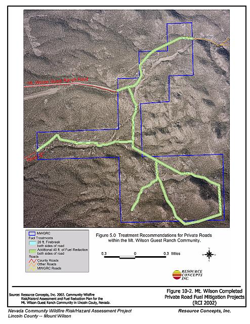
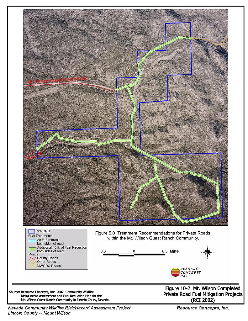
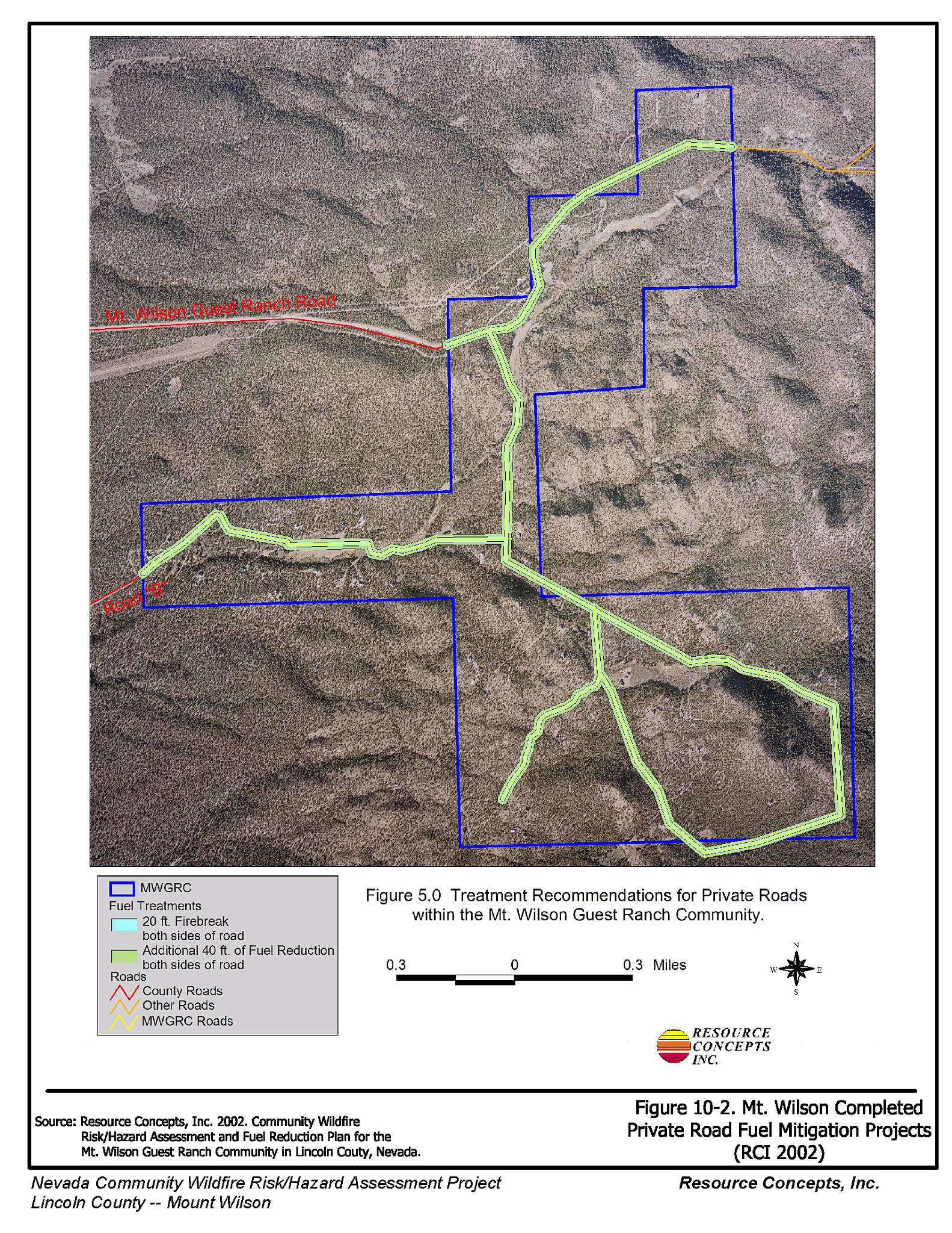
The Nevada Division of Forestry completed fuel reduction treatments along community roads during the spring and summer of 2004. Figure 10-2 illustrates the specifications and locations of the road treatments.
The Mt. Wilson Community has formed a local chapter of the Nevada Fire Safe Council. The support of the Council will promote implementation of the defensible space recommendations on private land and potentially assist with improving fire suppression capabilities in the Mt. Wilson area.
10.1.6 Factors Affecting Fire Behavior
Vegetation, dead and down fuels, and topographic features contribute to the potential fire hazard around wildland-urban interface communities. The fuel hazards maps and fuel hazard photo points are included in Figures 10-3 and 10-4.
Vegetation within the Mt. Wilson area consists primarily of dense, closed-canopy pinyon-juniper woodlands. Tree density was estimated at 400 to 450 trees per acre, tree height at thirteen to 28 feet, and canopy closure at seventy to eighty percent (RCI 2002). Ground fuels are nearly non-existent due to the heavy tree cover, although minor amounts of sagebrush, perennial grasses and cheatgrass were observed. Occasional springs on Mt. Wilson support willow, currant, rabbitbrush, and small stringer meadows. Slopes in the community reach up to thirty percent, with many homes situated at the end of long, narrow, steep driveways lined with heavy pinyon-juniper. Aspect is generally to the west. There are numerous rolling hills and drainages within the community. The steep topography and dense pinyon-juniper account for the extreme fuel hazard.
10.1.7 Fire Behavior Worst-Case Scenario
The worst-case scenario for the Mt. Wilson community would be a wind-driven fire that starts southwest of the community. A fire approaching from the west/southwest could block evacuation from the community, trapping residents. The heavy fuels and steep slopes would result in extreme fire behavior. There are no safe zones where residents could shelter. Fire suppression resources are a minimum of thirty minutes away, however any resources that could be effective in fighting a fire of the magnitude expected in the worst- case scenario are at least one hour away.
The recently completed fuelbreaks around the perimeter of the community provide an area from which firefighters can conduct an attack against an oncoming fire. However fire behavior in areas similar to the Mt. Wilson area has been documented to burn 1,000 acres per hour. The entire Mt. Wilson community is 810 acres in size. Depending on the point of ignition and under the worst-case wind conditions a catastrophic wildfire could burn through the community before suppression resources could arrive.
10.2 Risk and Hazard Reduction Recommendations
As part of this project, the RCI Project Team returned to Mt. Wilson to monitor the status of the recommendations from the 2002 report. The RCI Project Team found that several of the previously recommended fuel reduction treatments had been completed. A summary of the remaining recommendations to be completed for Mt. Wilson community is included below.
10.2.1 Defensible Space Treatments
Defensible space treatments are an essential first line of defense for residential structures. Significantly reducing or removing vegetation within a prescribed distance from structures (30 feet to 200 feet depending upon slope and vegetative fuel type) reduces fire intensity and improves firefighter and homeowner chances for successfully defending a structure against an oncoming wildfire.
Property Owner Recommendations
- Remove, reduce, and replace vegetation around homes according to guidelines provided in Appendix E. This area should be kept:
- Lean: There are only small amounts of flammable vegetation.
- Clean: There is no accumulation of dead vegetation or other flammable debris.
- Green: Existing plants are healthy and green during the fire season.
- Maintain defensible space annually.
- Maintain the area beneath unenclosed porches and decks free of accumulated vegetation or other flammable debris. Enclose these areas wherever possible.
- Store woodpiles at least thirty feet from any structure.
- Clear all vegetation and combustible materials around propane tanks for a minimum distance of ten feet.
- Remove pine needles, leaves, and debris from roofs and rain gutters.
- If a resident decides to keep some pinyon or juniper trees within the defensible space zone for aesthetic reasons, no other trees or shrubs should be within a minimum of thirty feet of the crown of the remaining tree. Limb pinyon and juniper tree branches a minimum of four feet from the ground, but not more than one-third the height of the tree. Remove all dead and diseased branches and duff from beneath the remaining trees.
- Prune tree branches to at least fifteen feet from chimneys, walls, and roofs of structures.
- Irrigate all trees and large shrubs near structures to increase their fire resiliency. This is especially important during drought conditions.
- Consider the purchase of fire suppression products such as fire blocking gels like BARRICADE®, or foams that can be applied to structures and vegetation to create an added layer of flame resistance in the event of a fire.
- Install spark arrestors on chimneys.
10.2.2 Fuels Reduction Treatments
Fuel reduction treatments are applied on a larger scale than defensible space treatments. Permanently changing the fuel characteristics over large blocks of land to a lower volume and altered distribution reduces the risk of a catastrophic wildfire in the treated area. Reducing vegetation along roadways and driveways could reduce the likelihood of wildfire spreading across roads and improve firefighter access and safety for protecting homes.
Property Owners
- Remove dense stands of rabbitbrush along Craw Creek.
Electric Utility Company
- Maintain utility right-of-ways by removing trees from beneath power lines and thinning shrubs within fifteen feet of utility poles.
Bureau of Land Management
- Remove and/or recycle the chip pile on the landing strip to reduce the fuel hazard to the community.
- Maintain the recently constructed fuel reduction treatment areas. The treated acreage and treatment prescription for the Mt. Wilson fuel reduction project was constrained by a court settlement. The original prescription for fuel reduction in the Mt. Wilson area included larger areas and more biomass removal. Fire suppression and safety for firefighters and residents would benefit from additional treatment.
10.2.3 Fire Suppression Resources
Adequate training, equipment, and water drafting supplies are critical to firefighters, be they first responders, volunteer fire department personnel, or agency personnel. These matters are of special importance to all communities, especially those located in remote portions of the county. The following recommendations are related to actions the county and fire departments can take to increase the quality of fire suppression response in their community.
Lincoln County and Mt. Wilson Fire Safe Council Chapter
- Install three 5,000-gallon water storage tanks, or one 15,000-gallon tank for fire suppression water storage in the Mt. Wilson community.
- Develop additional water sources along Craw Creek or install dry hydrants.
- Identify a minimum of four people from Mt. Wilson who would be likely to provide the initial response to a nearby ignition. Coordinate with the Bureau of Land Management or the Nevada Division of Forestry to provide them with Basic Wildland Firefighter Training.
- Purchase and station a pick-up truck and a one-piece, slip-on, 100 to 200-gallon tank and pump unit with hose and hose reel in Mt. Wilson during the fire season. This equipment, fitted properly for the size and weight limitations of the truck, can be used to provide initial attack of small ignitions.
- Allow burning only under a permit process or on designated community burn days. A sample burn permit is included in Appendix F.
Mt. Wilson Chapter Nevada Fire Safe Council Chapter
- Meet annually with the Bureau of Land Management to review their pre-attack plan for the area.
10.2.4 Community Coordination
Many of the most effective activities aimed at reducing the threat of wildfire for Mt. Wilson require that individual property owners coordinate with each other and with local fire authorities. Defensible space, for example, is more effective in small communities when applied uniformly throughout entire neighborhoods. Public education and awareness, neighbors helping neighbors, and proactive individuals setting examples for others to follow are just a few of the approaches that will be necessary to meet the fire safe goals in the community. Disposal of biomass generated from defensible space and fuel reduction treatments can sometimes be most efficiently handled through community programs.
Property Owners
- Assure that address signs are visible from the road. Address characters should be at least four inches high, reflective, and composed of non-flammable material. Improving visibility of addresses will make it easier for those unfamiliar with the area to navigate under smoky conditions during a wildland fire.
Mt. Wilson Chapter Nevada Fire Safe Council
- Distribute copies of the publication “Living With Fire.” This publication is free of charge, and copies can be requested from the University of Nevada Cooperative Extension.
Lincoln County
- Widen community roads to at least 22 feet or install turnouts every 350 feet.
- Coordinate with the Assessor’s Office and the Roads Department to ensure all roads are named, mapped, posted clearly, and identified with GPS locations.
- Require all future development in the County to meet National Fire Codes with regard to community design aspects: building construction and spacing, road construction and design, water supply, and emergency access. Require implementation of defensible space according to the requirements shown in Appendix E prior to construction. Refer to Appendix F for fire safe recommendations for planning in new developments.
| Involved Party | Recommended Treatment | Recommendation Description |
|---|---|---|
| Property Owners | Defensible Space | Remove, reduce, and replace vegetation around homes according to the guidelines in Appendix E. Maintain defensible space as needed to keep the space lean, clean, and green. |
| Fuel Reduction Treatments | Remove rabbitbrush along Craw Creek. | |
| Community Coordination | Assure that residential addresses are clearly visible from the road. Address characters should be at least four inches in height, and reflective so as to be visible at all times. | |
| Mt. Wilson Fire Safe Council Chapter | Community Coordination | Distribute copies of “Living With Fire,” available from the University of Nevada Cooperative Extension. |
| Fire Suppression Resources | Meet annually with the BLM to review their pre-attack plan for the area. | |
| Lincoln County Mt. Wilson Fire Safe Council Chapter |
Fire Suppression Resources | Install three 5,000-gallon or one 15,000-gallon water storage tank in the community. Identify a minimum of four people from Mt. Wilson who would be likely to provide the initial response to a nearby ignition. Coordinate with the Bureau of Land Management or the Nevada Division of Forestry to provide them with Basic Wildland Firefighter Training. Purchase and station a pick-up truck and a one-piece, slip-on, 100 to 200-gallon tank and pump unit with hose and hose reel in Mt. Wilson during the fire season. Allow burning only on designated days under a permit process. A sample burn permit is included in Appendix F. Develop additional water sources in Craw Creek or install dry hydrants. |
| Lincoln County | Community Coordination | Widen community roads to at least 22 feet or install turnouts every 350 feet. Collaborate with the Assessor’s Office and the Roads Department to ensure all roads are named, mapped, posted clearly, and identified with GPS locations. Ensure that all new development in the area conforms to National Fire Code community design and fire safe construction standards. |
| Utility Company | Fuel Reduction Treatments | Maintain utility right-of-ways by removing trees from beneath power lines and thinning shrubs within fifteen feet of utility poles. |
| Bureau of Land Management | Fuel Reduction Treatments | Remove the pile of wood chips from the landing strip. Maintain fuel reduction treatments and expand treatment areas if possible. |
Figure 10-1.
Figure 10-2.
Figure 10-3.
Figure 10-1Mt. Wilson Fire History and Completed Mitigation Projects |
 |
Figure 10-2Mt. Wilson Completed Private Road Fuel Mitigation Projects |
 |
Figure 10-3Mt. Wilson Fuel Hazard Classification |
 |
Figure 10-4. Mt. Wilson Fuel Hazard Photo Points
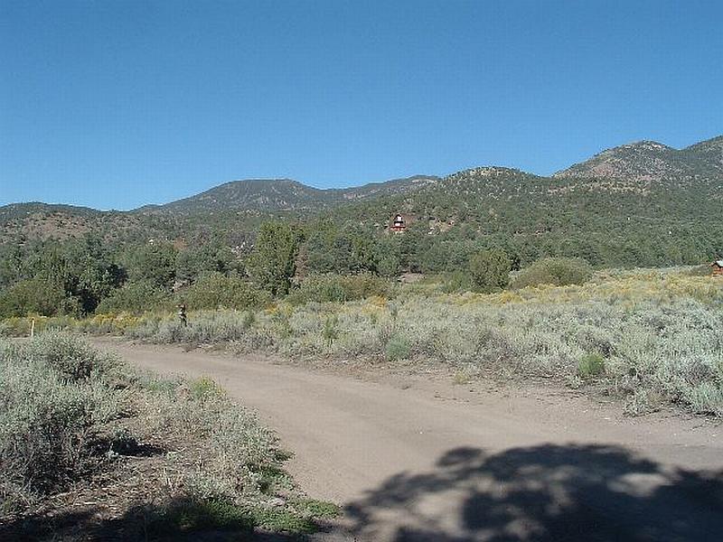
Photo Point 1. 4235547N, 724095E, 60°NE. Typical conditions in the Mt. Wilson community include narrow dirt roads located in extreme fuel hazard sagebrush and pinyon-juniper vegetation types.
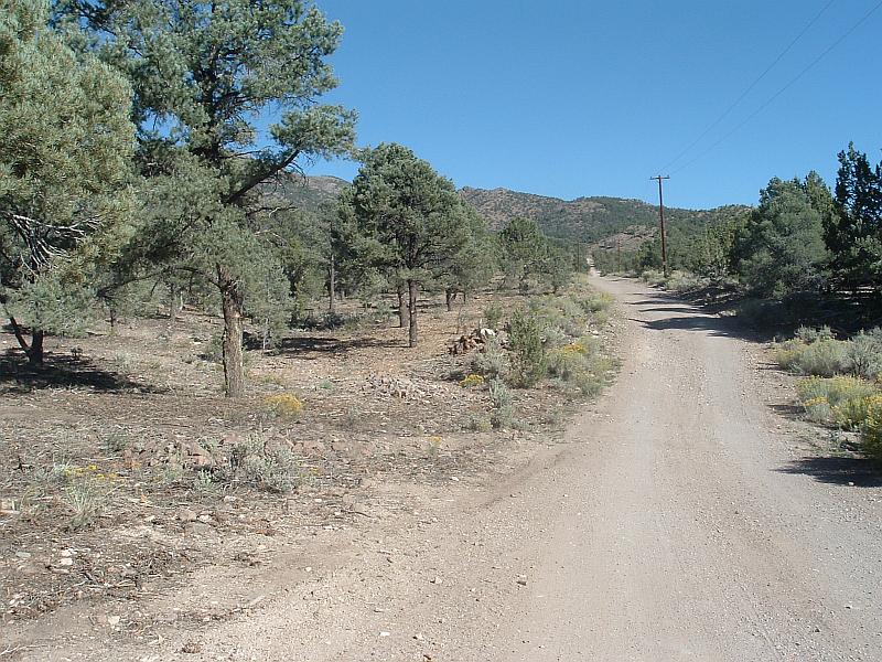
Photo Point 2. 4235957N, 723880E, 115°SE. Trees have been thinned and limbs pruned on remaining trees along private roads within the Mt. Wilson community. Before thinning tree density was estimated at 400 to 450 trees per acre.

Photo Point 3. (No coordinates available) Aerial view of Mt. Wilson looking south showing fuel reduction treatments on the north, west, and south sides of the Mt. Wilson community. The Bureau of Land Management completed the portions of project on public land; the private land portions of the project were completed by the Nevada Division of Forestry.