![]()
![]()
11.0 Panaca
11.1 Risk and Hazard Assessment
In 2002, Resource Concepts, Inc. completed an assessment entitled Community Wildfire Risk Assessment and Fuel Reduction Plan for Panaca in Lincoln County, Nevada on behalf of Lincoln County. The pertinent information for this report is summarized from the RCI Panaca assessment.
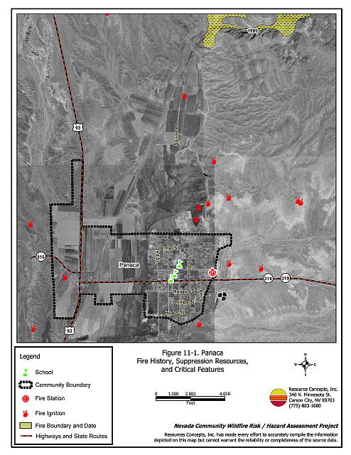
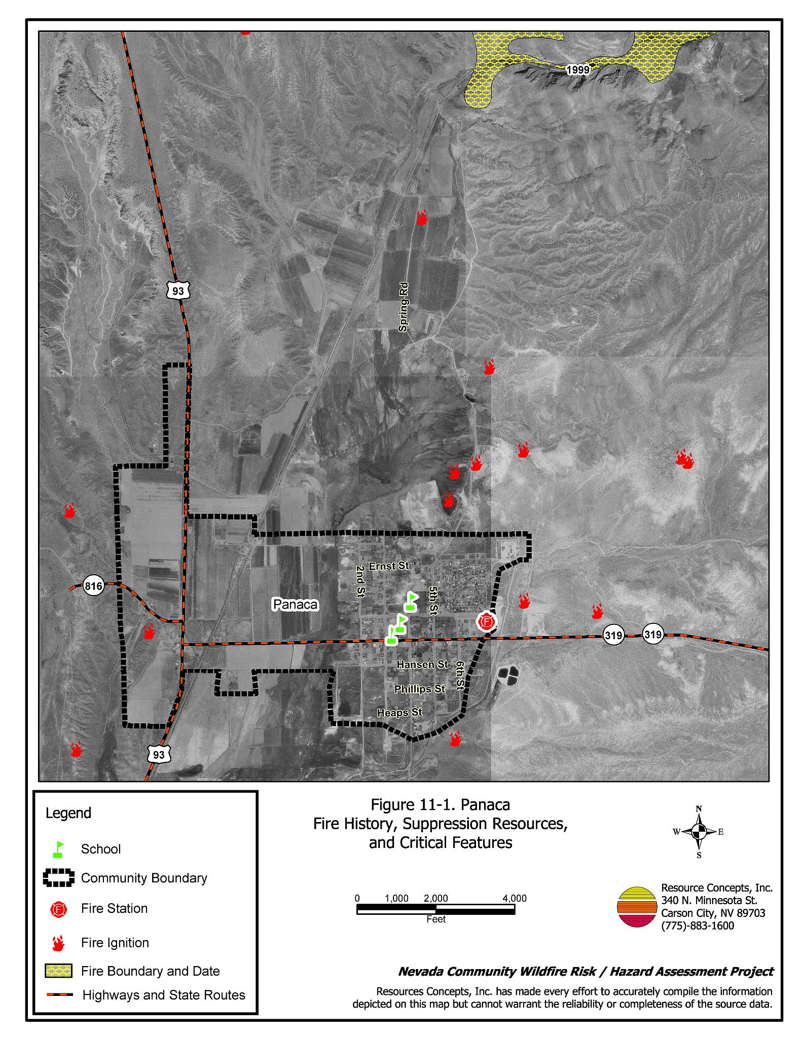
Panaca is located in west-central Lincoln County on U.S. Highway 93, approximately fifteen miles north of Caliente and fifteen miles south of Pioche. The risk/hazard assessment resulted in classifying Panaca in the Moderate Hazard category. The moderate rating was attributed to limited fire suppression resources and high density housing. There were some areas where slopes and heavier vegetation contributed to the hazard. See Figure 11-1 for details of the Panaca community boundary.
11.1.1 Community Design
The wildland-urban interface area around Panaca is a classic interface condition. There is a clear line of demarcation between structures and wildland fuels. Thirty percent of homes were on a lot of one acre or less.
- Access: State Route 319 leading east from U.S. Highway 93 is the major transportation route to Panaca. The highway is at least 24 feet wide, paved, and has adequate turnaround space for fire suppression equipment. Secondary roads in the community are of adequate width, grade, and turn-around space for fire suppression equipment maneuverability and two-vehicle passage.
- Signage: The majority of streets and addresses are properly identified in Panaca. Clear and visible street signs and residential addresses are important for locating homes during low visibility conditions that occur during a wildfire.
- Utilities: All of the utilities were above ground. Power line corridors had been properly maintained to minimize wildfire damage to electric utilities and reduce the possibility that sparks created by arcing power lines could start a fire in adjacent vegetation.
11.1.2 Construction Materials
Ninety-nine percent of the homes observed in the interface area were built with non-combustible roofing such as composition, metal, or tile. Siding was not considered as a factor. Approximately 25 percent of the homes had unenclosed porches, decks, or balconies that create drafts and provide areas where sparks and embers can be trapped, smolder, and ignite, rapidly spreading fire to the house.
11.1.3 Defensible Space
Seventy-five percent of the homes observed in the interface met the minimum recommended defensible space distance to help protect the home from damage or loss during a wildfire.
11.1.4 Suppression Capabilities
Wildfire Protection Resources
Panaca is protected by the Panaca Volunteer Fire Department, which reported having twenty volunteers at the time that interviews were conducted for this project. Additional resources are available through the Bureau of Land Management Caliente and Pony Springs Fire Stations and The Nevada Division of Forestry Pioche Conservation Camp as described in Section 4.1.1. Table 11-1 lists the outside wildfire resources available for initial response to a reported wildland fire near Panaca.
| Type of Equipment | Amount of Equipment | Cooperating Partner (Resource Location) |
|---|---|---|
| Type 3 Engine Type 4 Engine Type 6 Engine Type 1 Engine* |
1 1 1 3 |
Panaca VFD |
| Source: Harry Birkmier Panaca VFD Chief | ||
| * These three engines would be used for structure protection but would not likely be used for initial attack of a wildland fire. | ||
Water Sources and Infrastructure
Water availability for fire suppression resources in Panaca includes a hydrant system, with 500 gpm hydrants within 1,000 feet of structures.
11.1.5 Factors Affecting Fire Behavior
Panaca is bordered on the west by irrigated agricultural lands and on the remaining sides of town by salt desert shrub vegetation including Wyoming big sagebrush, fourwing saltbush, spiny hopsage, and ephedra reaching three to five feet in height. Red brome and cheatgrass have invaded some areas of town, posing a fuel hazard within the community, especially in years of higher moisture when annual grass production increases. A disturbed area on the east side that may have initially been constructed as a fuelbreak is an ideal site for invasion of these annual grasses. A few small wildfires have occurred near Panaca and one large wildfire was recorded northeast of the community in 1999.
11.1.6 Fire Behavior Worst-case Scenario
The worst-case scenario for a wildfire in the area surrounding Panaca would be a wind driven fire that starts south of the community in a year with higher than normal precipitation when cheatgrass growth would contribute to higher fuel loading. A fire would move rapidly through the fine fuel layer into shrubs and any structures without adequate defensible space.
11.2 Risk and Hazard Reduction Recommendations
As part of this project, the RCI Project Team returned to Panaca to monitor the status of the recommendations from the 2002 report. The RCI Project Team found that several of the previously recommended defensible space recommendations had been completed. A summary of the remaining recommendations to be completed for Panaca is included below.
11.2.1 Defensible Space Treatments
Defensible space treatments are an essential first line of defense for residential structures. Significantly reducing or removing vegetation within a prescribed distance from structures (minimum of 30 feet to 200 feet depending upon slope and vegetative fuel type) reduces fire intensity and improves firefighter and homeowner chances for successfully defending a structure against an oncoming wildfire.
Property Owner Recommendations
- Remove, reduce, and replace vegetation around homes according to guidelines provided in Appendix E. This area should be kept:
- Lean: There are only small amounts of flammable vegetation.
- Clean: There is no accumulation of dead vegetation or other flammable debris.
- Green: Existing plants are healthy and green during the fire season.
- Maintain this defensible space annually.
- Immediately remove cleared vegetation to an approved disposal site when implementing defensible space treatments. This material dries quickly and presents a fire hazard if left on site.
- Store firewood a minimum of thirty feet away from structures.
- Clear and maintain a minimum distance of ten feet around propane tanks free of accumulated vegetation and combustible materials.
- Enclose the areas underneath decks, porches, and balconies; or maintain them free of weeds and other debris.
- Ensure that residential addresses are clearly visible from the road. Address characters should be at least four inches in height, and reflective so as to be visible at all times.
- Prune or remove shrubs near trees to reduce ladder fuels.
- Install spark arrestors on chimneys.
- Board up or remove abandoned trailers and other structures to prevent sparks entering and igniting these structures.
- Mow or otherwise remove brush growing along fences in the community.
- Reduce vegetation along irrigation channels and unlined ditches.
11.2.2 Fire Suppression Resources
Adequate training, equipment, and water drafting supplies are critical to firefighters, be they first responders, volunteer fire department personnel, or agency personnel. These matters are of special importance to all communities, especially those located in remote portions of the county. The following recommendations are related to actions the fire department can take to increase the quality of fire suppression response in their community.
Panaca Volunteer Fire Department
- Mow or otherwise remove vegetation within ten feet of all fire hydrants.
- Meet annually with the Bureau of Land Management to review their pre-attack plan for the area.
- Allow burning only under a permit process or on designated community burn days. A sample burn permit is included in Appendix F.
11.2.3 Community Coordination
Public education and awareness, neighbors helping neighbors, and proactive individuals setting examples for others to follow are just a few of the approaches that will be necessary to meet the fire safe goals in Panaca.
Panaca Volunteer Fire Department
- Establish a brush and weed clearance program for the community with a designated site for timely disposal of biomass.
- Distribute copies of “Living With Fire,” available from the University of Nevada Cooperative Extension.
Lincoln County
- Require all future development in the County to meet National Fire Codes with regard to community design aspects: building construction and spacing, road construction and design, water supply, and emergency access. Require implementation of defensible space according to the requirements shown in Appendix E prior to construction. Refer to Appendix F for fire safe recommendations for planning in new developments.
| Involved Party | Recommended Treatment | Description of Area to be Treated |
|---|---|---|
| Property Owners | Defensible Space | Remove, reduce, and replace vegetation around structures and ranch asset storage areas according to the guidelines in Appendix E. Maintain this defensible space annually. |
| Panaca Volunteer Fire Department | Fire Suppression Resources | Mow or otherwise remove vegetation within 10 feet of all fire hydrants. Meet annually with the BLM to review their pre-attack plan for the area. Allow burning only on set days under a permit process. A sample burn permit is included in Appendix F. |
| Community Coordination | Establish a brush and weed clearance program for the community. Distribute copies of “Living With Fire,” available from the University of Nevada Cooperative Extension, (775) 784-4848. |
|
| Lincoln County | Community Coordination | Collaborate with the Assessor’s Office and Roads Department to ensure all new development roads are named, mapped, posted clearly, and identified with GPS locations. Require all new development to meet National Fire Code community design and fire safe construction standards. |
Figure 11-1Panaca Fire History, Suppression Resources, and Critical Features |
 |