![]()
![]()
5.0 Incline Village
5.1 Incline Village Hazard And Risk Assessment Summary
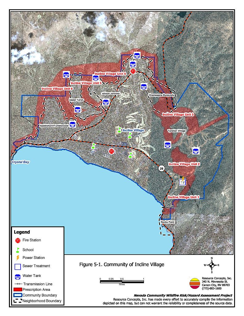
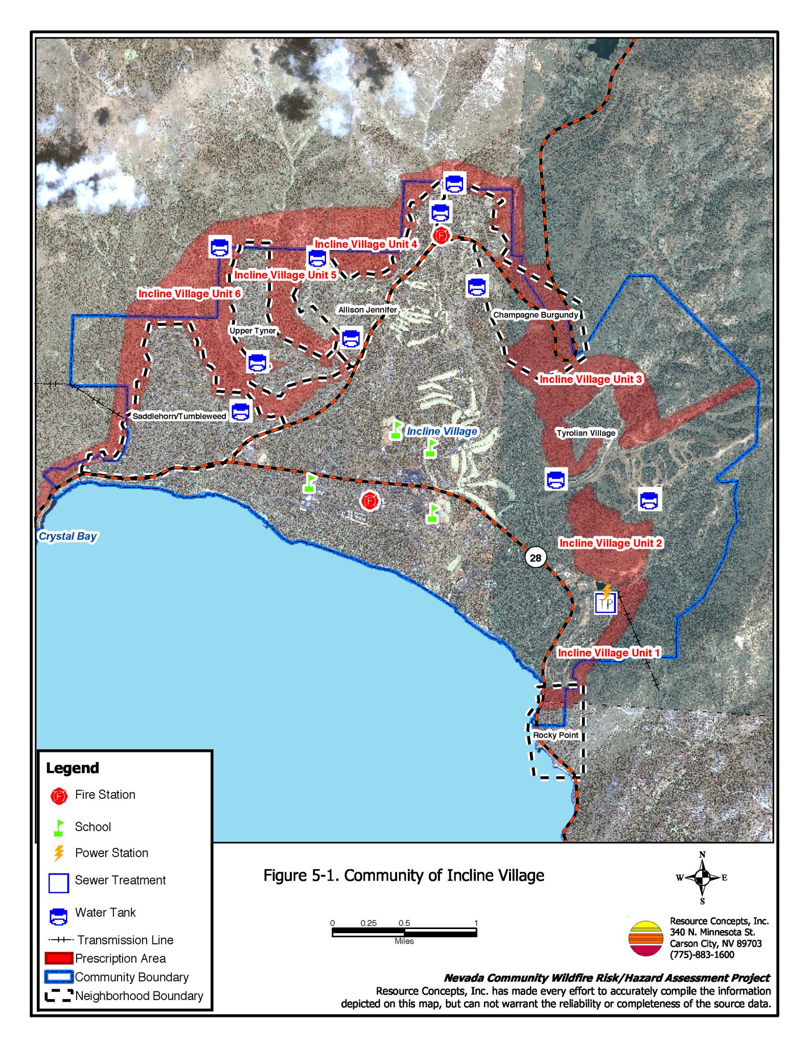
Incline Village is in the northeastern corner of the Lake Tahoe Basin (Figure 5-1). The community is situated in terrain that ranges from gently sloping near the lakeshore to very steep near the higher elevations. The risk assessment resulted in classifying Incline Village, as a whole, in the Extreme Hazard category (76 points). This score is attributed primarily to inadequate defensible space, combustible building materials, heavy fuels, and steep slopes.
Incline Village was divided into six different “neighborhood” areas and assessed based on the neighborhood boundaries. This type of boundary definition was chosen because Incline Village is composed of areas of varying topography, access, residential structure composition, and other factors that affect the hazard rating. However, certain other assessment factors are the same throughout all of Incline Village. Physical conditions, fire behavior factors, worst-case scenarios, defensible space, and the majority of recommendations, were similar for all areas of Incline Village. Those factors will be addressed here, and the recommendations summarized; factors and recommendations that differ neighborhood-by-neighborhood are addressed in the specific neighborhood sections.
The Incline Village neighborhoods are:
- Allison / Jennifer
- Champagne / Burgundy
- Rocky Point
- Saddlehorn / Tumbleweed
- Tyrolian Village
- Upper Tyner
- Incline Village Interior
5.1.1 Community Design
The urban interface condition surrounding Incline Village and all of the neighborhoods within Incline Village is classified as an intermix condition. Structures are scattered throughout the wildland area. There is no clear line of demarcation between structures and wildland fuels along roads or back fences.
- Roads: State Route 431 and 28 are the primary access to Incline Village.
- Signage: Adequate street signs are present for almost all of the roads in the community. Likewise, homes have visible addresses. The clear and visible signage will assist fire suppression personnel in locating residences during poor visibility conditions that may exist during a wildland fire.
- Utilities: Utilities are all underground in the newer developments and both above and below ground in the older neighborhoods. In many areas, powerlines do not have proper vegetation clearances.
5.1.2 Construction Materials
Many of the homes do not have non-combustible roofs and/or non-combustible siding materials. The majority of the homes in the community have unenclosed balconies, porches, decks or other architectural features that create drafts and provide areas where sparks and embers can smolder and rapidly spread fire to the home.
5.1.3 Defensible Space
Of the hundreds of homes in Incline Village, only 20 homes observed during the assessment meet the defensible space landscape requirement to minimize damage to the home, and/or loss during a wildfire. The terrain is generally steep, with heavy tree and shrub vegetation. The TRPA and NLTFPD MOU recommends a defensible space zone extending out from structures for a minimum of 30 to 100 feet. Appendix D describes defensible space requirements to be in compliance with state and local fire safety ordinances.
5.1.4 Physical Conditions
The topography in Incline Village consists of steep slopes that are generally greater than 30 percent, canyons, and drainages that, in concert with strong winds could create a chimney effect during a wildfire, drawing fire through the canyons and drainages and into communities. The dominant vegetation layer in Incline Village is a tree overstory of Jeffrey pine and white fir, with some incense cedar, sugar pine; and willow, aspen, and alder in the stream zones. The tree canopy is closed. The shrub layer includes manzanita, snowbrush, bitterbrush, huckleberry oak, bitter cherry, chinkapin, currant, and whitethorn. Shrubs are typically four to 10 feet tall. Ground fuels consist of pine needles, pine cones, annuals, and grasses. Greenbelt areas currently have high volumes of dead and down fuels. Fuels in the community are heavy, estimated at six to 12 tons per acre. The area may experience strong downslope winds during thunderstorms. There are continuous fuels in close proximity to structures. The composition of the fuels is conducive to crown fires or high intensity surface fires. The steep slopes, southern aspects, dense fuels, heavy duff, prevailing wind exposure and ladder fuels may reduce fire suppression effectiveness.
5.1.5 Worst-Case Scenario
There are two general worst-case scenarios for Incline Village. An ignition that begins downslope of the community could be driven up canyons and drainages by strong winds, fueled by the dense ground and understory fuels, eventually becoming a crown fire. Homes in thick tree stands or with trees and vegetation overhanging roofs and decks are at severe risk of structure damage or loss, especially those with wood shake roofs and unenclosed architectural features with brush underneath. Such structural composition invites sparks and smoldering embers, and eventual ignition of the home. The steep slopes and thick tree canopy would allow quick spread of the fire and extreme flame lengths. Several areas can be accessed by only one road. Limited access is a safety hazard for both the firefighters and the public. During a major wildfire event, visibility would be reduced. Residents trying to leave the area, and fire fighters trying to enter, may have difficulties in two-vehicle passage with the reduced visibility. Ignitions upslope driven by downslope winds is a similar version of this first worst-case scenario.
The second worst-case scenario is a structure fire that spreads into wildland fuels adjacent to the home. Home spacing is a risk factor in Incline Village in that radiant heat from one house fire can ignite homes in close proximity. Combustible roofs, unenclosed structural features, and inadequate defensible space all contribute to the hazard in this type of scenario.
5.1.6 Risk Assessment
Incline Village has a high potential for ignition, as well as structure loss in the event of a wildfire. The primary risks are lightning; escaped fire from auto accidents on the highway; and the possibility of a fire starting from unextinguished cigarettes thrown out of car windows. In many areas power lines are an ignition risk because the rights-of-way have not been properly maintained.
5.2 Incline Village Risk And Hazard Reduction Recommendations, Roles And Responsibilities
The responsibility to keep a community fire safe falls not only on the local fire department but also on the residents of the community, businesses, and local governments. General recommendations related to defensible space, fuel reduction, community preparedness, and public education, are included in Chapter 4.0, District-wide Assessment Results.
There are six fuel reduction treatments recommended for the Incline Village Community. These treatments are described in detail in Chapter 7.0, Recommended Hazard Mitigation Projects and briefly summarized below.
- Incline Village Unit 1
- Thinning and Brush Removal; Fuelbreak
- Create a fuel break 600 feet wide from Highway 28 to Mill Creek. This unit is on the eastern boundary of the Incline Village Interior Neighborhood
- Incline Village Unit 2
- Thinning and Brush Removal; Fuelbreak
- Create a fuel break 300 feet wide along the north slope of the prescription area that borders the road to the Diamond Peak Ski Resort. This unit is on the eastern boundary of the Incline Village Interior neighborhood and the southern end of the Tyrolian Village neighborhood.
- Incline Village Unit 3
- Thinning and Brush Removal; Shaded Fuelbreak
- Create a shaded fuel break 400 feet wide on the east side of Tyrolian Village and along the north side of the Diamond Peak Ski Resort.
- Incline Village Unit 4
- Thinning and Brush Removal
- Thin trees and remove brush along the Apollo Court are along the outer edges of the Allison/Jennifer and Champagne/Burgundy neighborhoods.
- Incline Village Unit 5
- Thinning and Brush Removal
- Thin trees and remove brush in the open space / stream zone area between the Allison/Jennifer and Upper Tyner neighborhoods.
- Incline Village Unit 6
- Second Creek Thinning and Brush Removal
- Thin trees and remove brush in the Second Creek drainage between the Upper Tyner and the Saddlehorn/Tumbleweed neighborhoods.
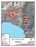
Figure 5-1Community of Incline Village |
 |
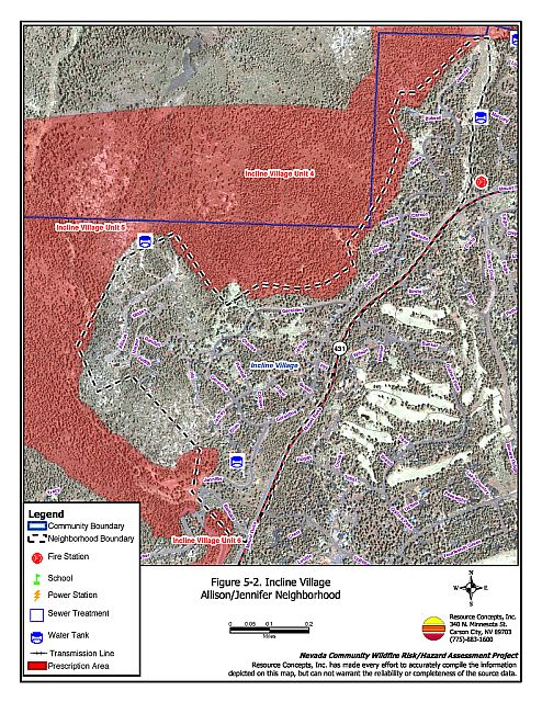
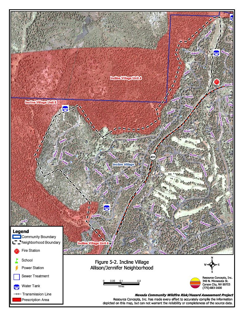
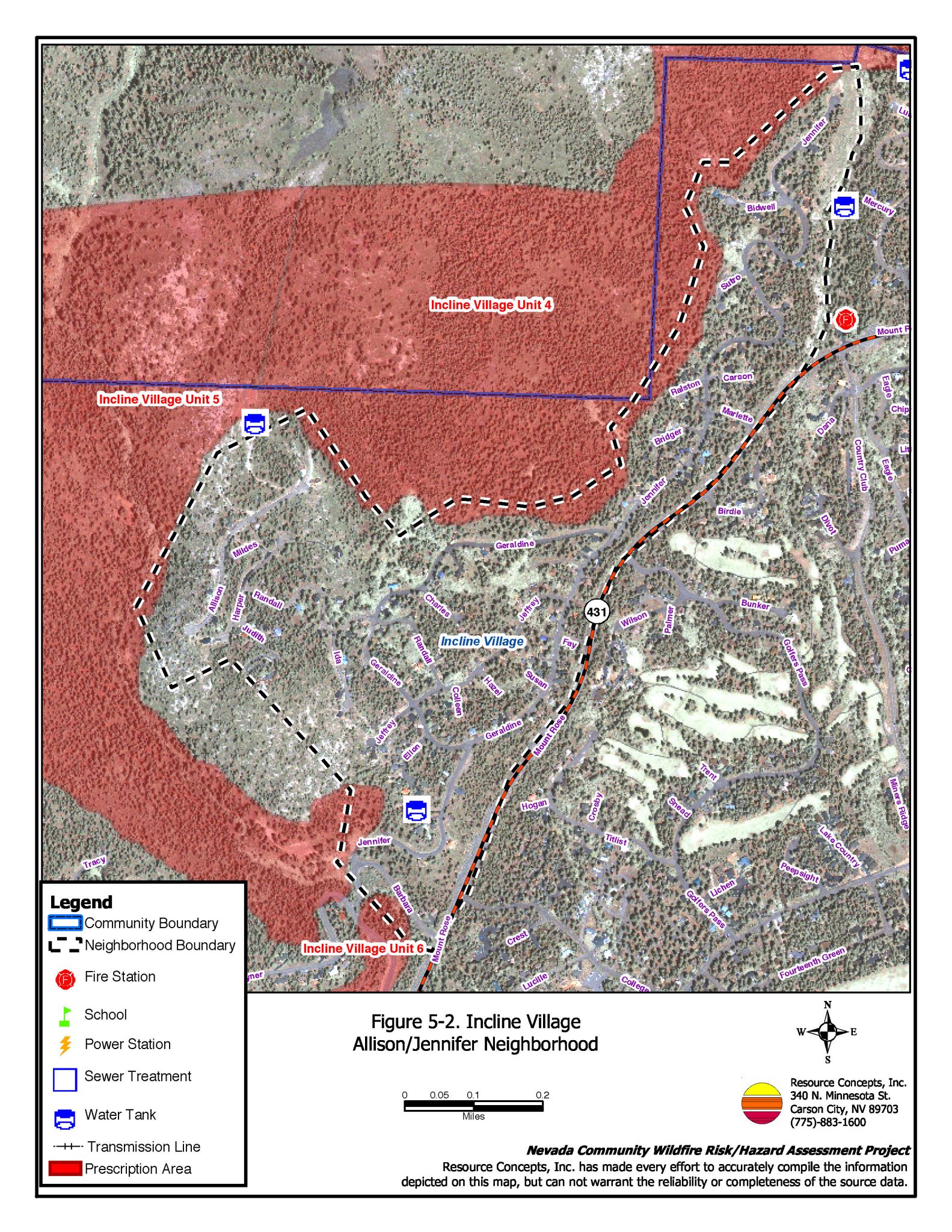
5.3 Allison/Jennifer
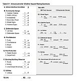
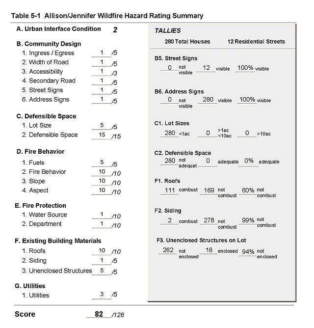
Allison/Jennifer is located in the northern-most portion of Incline Village (Figure 5-2). The area surrounding the neighborhood is forested by Jeffery pine and white fir. The developed portion of the neighborhood is adjacent to IVGID-developed green belts to the north, west and south. The greenbelt areas were cleared or thinned in 1991 through a helicopter logging operation and a pile burning plan spanning several years. The risk assessment resulted in classifying Allison/Jennifer in the Extreme Hazard category (82 points). This score is attributed primarily to close spacing of homes within heavy tree stands without adequate defensible space; some homes with combustible roofing material; a high number of homes with unenclosed decks or porches; and the potential for extreme fire behavior. The neighborhood assessment rating sheet is provided as Table 5-1.
5.3.1 Community Design
There were 280 single-family residences observed in the assessment. There are numerous undeveloped lots in the neighborhood, and three greenbelts located above SR 431 (NLTFPD, 2003). The majority of the lot sizes are less than one acre.
- Roads: State Route 431 is the primary access to the neighborhood. There are two secondary roads that connect with SR 431, one in the upper and one in the lower portion of the neighborhood. The majority of roads have a grade of less than five percent, have adequate width and turnaround space for two-vehicle passage or fire suppression equipment to maneuver, but have sharp turns that might interfere with visibility.
- Signage: Street signs and residential addresses are present on all of the roads in the neighborhood. There were 27 residential roads observed in the assessment area. The clear and visible signage will assist fire suppression personnel in locating residences during poor visibility conditions that may exist during a wildland fire.
- Utilities: Utilities are all underground in this neighborhood and do not pose an ignition risk.
5.3.2 Construction Materials
One hundred and eleven (60%) of the residences have fire resistant roof materials such as composition roofing, metal, or tile. Two hundred seventy eight (99%) of the residences have fire resistant siding materials.
Nearly all of the homes (94%) in the neighborhood have unenclosed balconies, porches, decks or other architectural features that create drafts and provide areas where sparks and embers can smolder and rapidly spread fire to the home.
Figure 5-2Incline Village Allison/Jennifer Neighborhood |
 |
Table 5-1Allison/Jennifer Wildfire Hazard Assessment Rating Sheet |
 |
5.4 Champagne/Burgundy
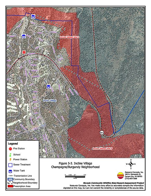
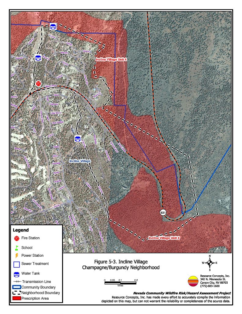
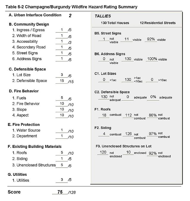
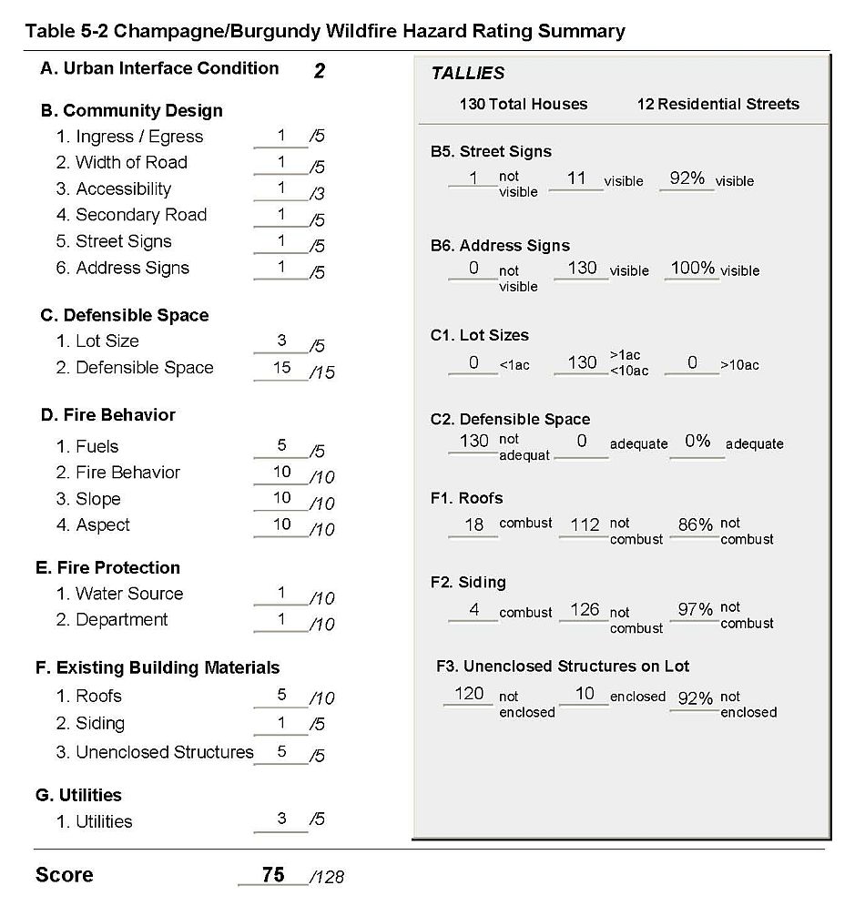
Champagne/Burgundy is located in the northeastern portion of Incline Village (Figure 5-3). The area surrounding the neighborhood is located on a steep south-facing slope. Vegetation consists of a dominant tree layer composed of Jeffrey pine and white fir, with some lodgepole pine, incense cedar, and red fir. The risk assessment resulted in classifying Champagne/Burgundy in the High Hazard category (75 points). This score is attributed primarily to inadequate defensible space, a high number of unenclosed decks and porches, steep topography and heavy fuel loading. The neighborhood assessment rating sheet is included as Table 5-2.
5.4.1 Community Design
There were 130 single-family residences observed in the assessment area, located on both sides of SR 431. Many of the homes in the area are in excess of 10,000 square feet and are on lots between 1 and 10 acres.
- Roads: State Route 431 is the primary access to the neighborhood. There are five secondary roads that access SR431. The majority of roads have a road grade of more than 5 percent. Many of the residential streets do not have adequate space to maneuver fire suppression equipment or for two-vehicle passage.
- Signage: Street signs are present and visible on all but one of the residential streets in the assessment area. Residential addresses are visible on all of the homes. The clear and visible signage will assist fire suppression personnel in locating residences during poor visibility conditions that may exist during a wildland fire.
- Utilities: Utilities are both above and below ground. Overhead power lines pose an ignition risk due to the lack of right-of-way maintenance. Some residences have propane tanks and many do not have the minimum fuel clearance of 10 feet.
5.4.2 Construction Materials
One hundred twelve (86%) of the residences in the assessment area have fire resistant roof materials such as composition roofing, metal, or tile. One hundred twenty six (97%) of the residences have fire resistant siding materials.
Nearly all of the homes (92 percent) in the neighborhood have unenclosed balconies, porches, decks or other architectural features that create drafts and provide areas where sparks and embers can smolder and rapidly spread to the home.
Figure 5-3Incline Village Champagne/Burgundy Neighborhood |
 |
Table 5-2Champagne/Burgundy Wildfire Hazard Assessment Rating Sheet |
 |
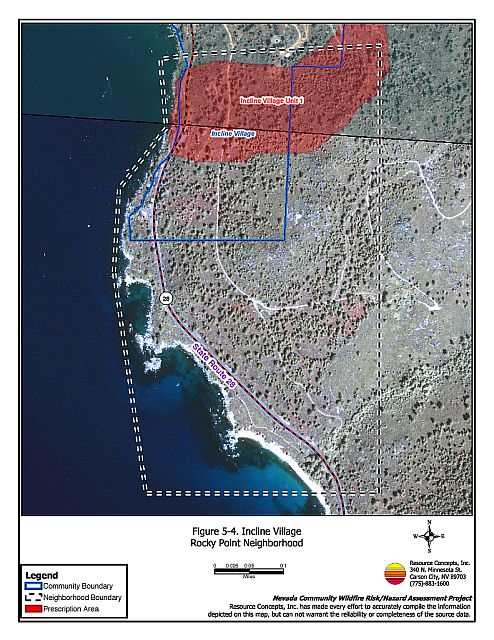
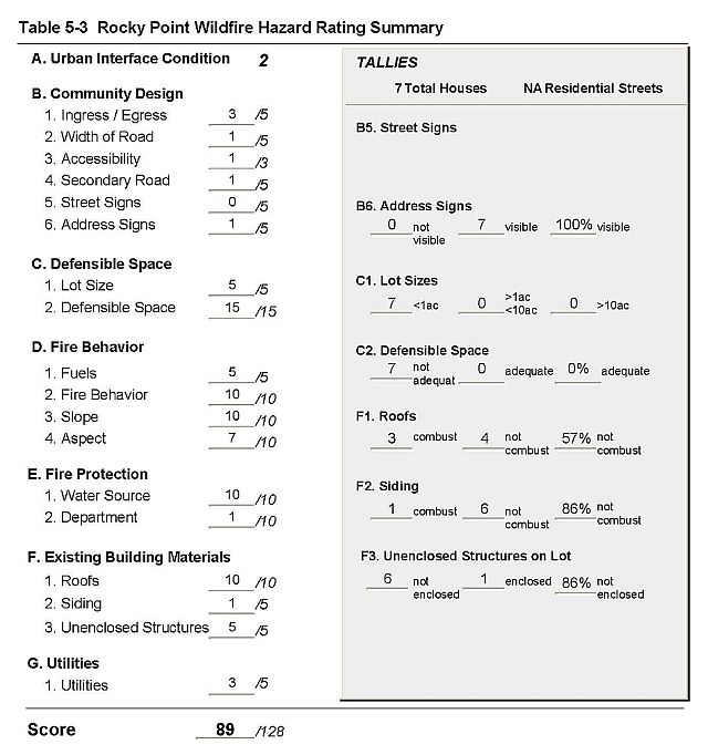
5.5 Rocky Point
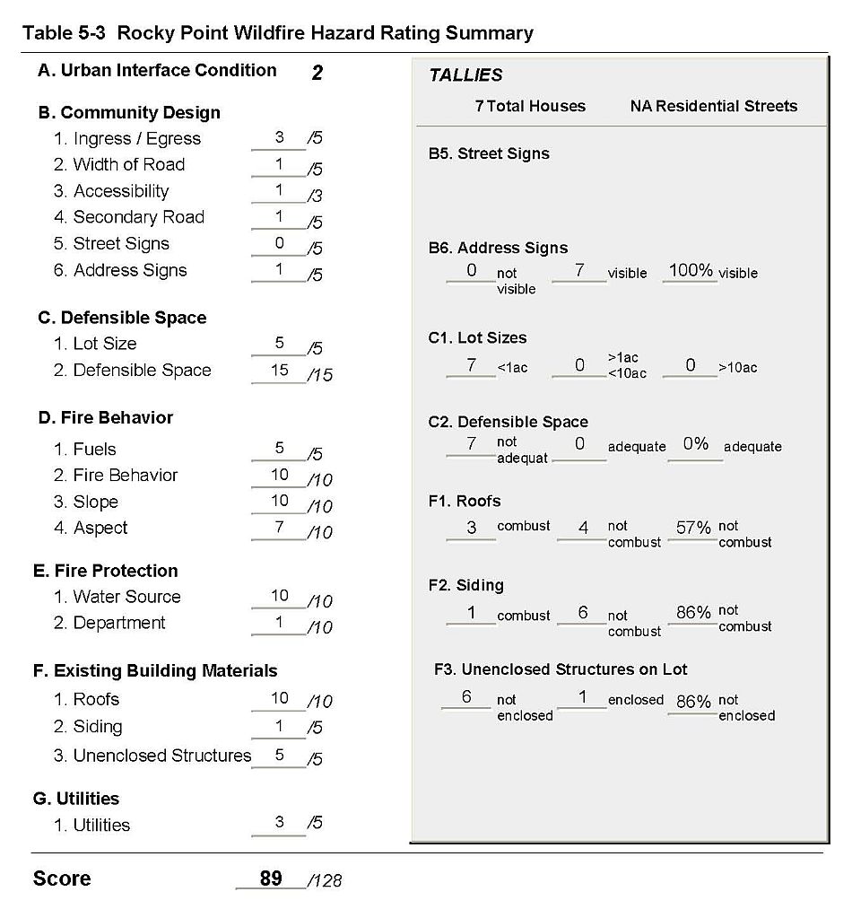
Rocky Point is located in the southeastern area of Incline Village (Figure 5-4). The risk assessment resulted in classifying Rocky Point in the Extreme Hazard category (91 points). This score is attributed primarily to inadequate defensible space, heavy fuels, steep west facing slopes, a lack of water sources for fire suppression, and unenclosed architectural features on nearly all of the homes. The neighborhood assessment rating sheet is provided in Table 5-3.
5.5.1 Community Design
All of the seven homes in the neighborhood are on lots of less than one acre.
- Roads: State Route 28 is the primary access road through Rocky Point. There is one secondary residential road leading into the neighborhood from SR 28. The roads have less than five percent grades and provide adequate space to maneuver fire engines or for two-vehicle passage.
- Signage: Street signs and residential addresses were considered Not Applicable in Rocky Point because there is only one secondary road leading into the neighborhood and only seven homes.
- Utilities: The majority of the utilities in the Rocky Point area are above ground. Overhead power lines pose an ignition risk because in several areas the utility rights-of-way are not properly maintained. Most residences have propane tanks and many do not have the minimum fuel clearance of 10 feet.
5.5.2 Construction Materials
Four of the seven homes (57%) have non-combustible roofing materials such as tile, metal, or composition, and six of the seven homes (86%) have non-combustible siding materials. Six homes (86%) have unenclosed balconies, porches, decks or other architectural features that can create drafts and provide areas where sparks and embers can smolder and spread fire to the home.
Figure 5-4Incline Village Rocky Point Neighborhood |
 |
Table 5-3Rocky Point Wildfire Hazard Assessment Rating Sheet |
 |
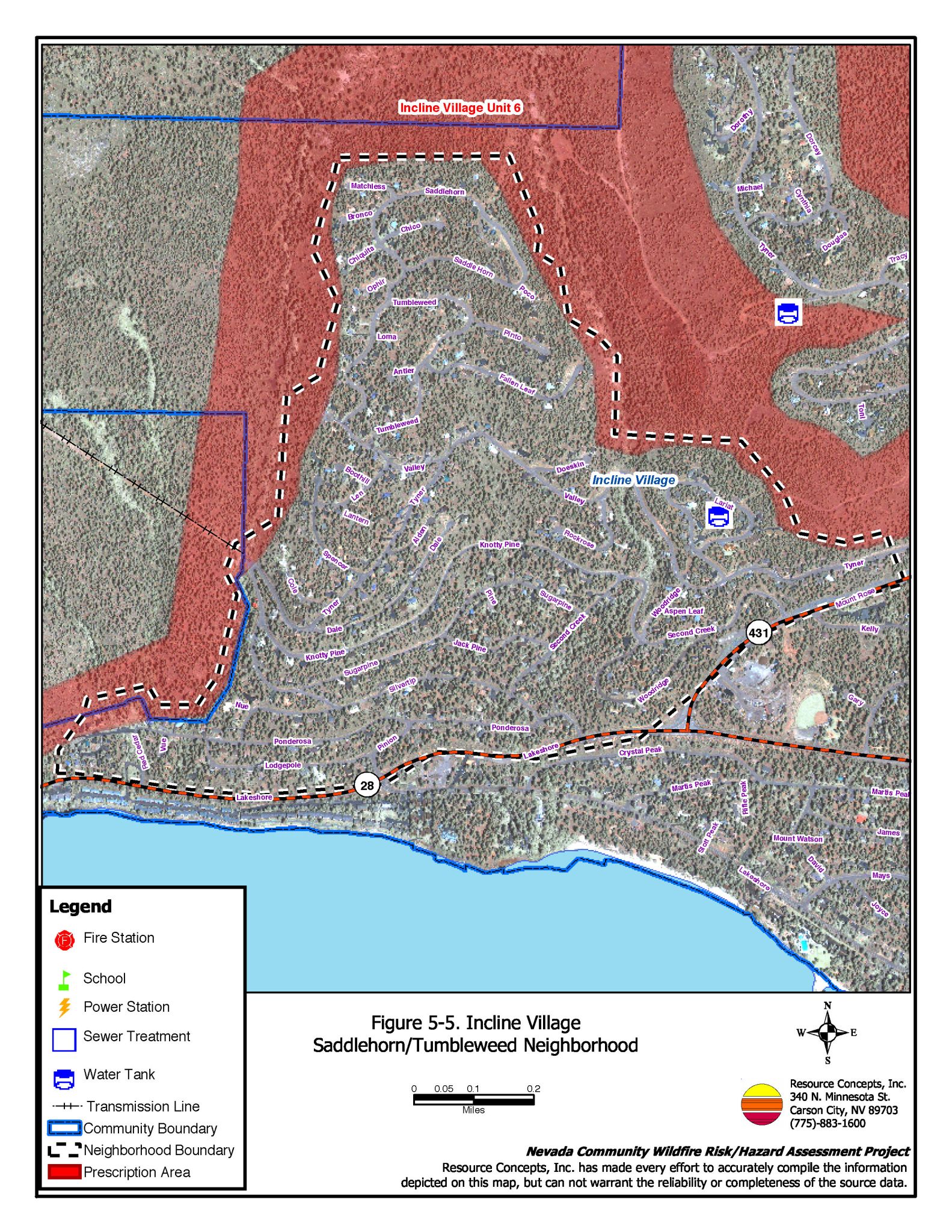
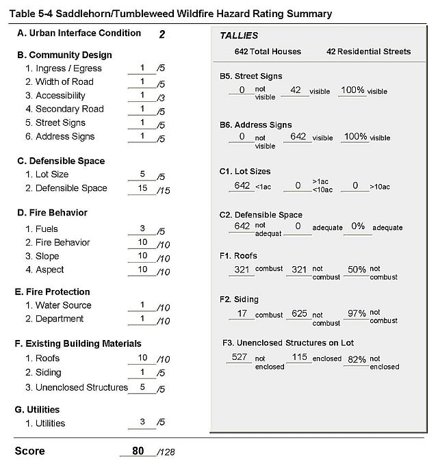
5.6 Saddlehorn/Tumbleweed
Saddlehorn/Tumbleweed is located in the southwestern portion of Incline Village (Figure 5-5). The area surrounding the neighborhood is located on steep southwest and east facing slopes. Vegetation cover includes pine, fir, and cedar intermixed with manzanita and bitterbrush. The risk assessment resulted in classifying Saddlehorn/Tumbleweed, in the Extreme Hazard category (80 points). The score is attributed primarily to inadequate defensible space, a high number of unenclosed porches or decks, steep terrain and heavy fuel loads. In addition, about one-quarter of the homes are constructed with combustible roofing materials. The community assessment rating sheet is provided as Table 5-4.
5.6.1 Community Design
The urban interface condition surrounding Saddlehorn/Tumbleweed is classified as an intermix condition. Structures are scattered throughout the wildland area. There is no clear line of demarcation between structures and wildland fuels along roads or back fences. There were 642 single-family residences observed in the assessment area. The majority of the homes are situated on lots of less than one acre in size.
- Roads: State Route 431 and Tahoe Blvd. (SR 28) are the primary access roads to the neighborhood. There were 42 residential secondary roads that lead from the primary roads into the neighborhood. The majority of the roads have greater than five percent grade. Many of the streets are narrow and winding, and do not have adequate space to maneuver fire suppression equipment or for two-vehicle passage.
- Signage: Street signs are present and visible on all of the streets in the area, and residential addresses were visible on all of the homes. The clear and visible signage will assist fire suppression personnel in locating residences during poor visibility conditions that may exist during a wildland fire.
- Utilities: Utilities are located both above and below ground. Overhead power lines pose an ignition risk because in several areas the utility right-of-way is not properly maintained. Some residences have propane tanks and many do not have the minimum fuel clearance of 10 feet.
5.6.2 Construction Materials
One half of the residences (50%) have fire resistant roof materials such as composition roofing, metal, or tile. Nearly all of the residences (97%) have fire resistant siding materials.
Well over three quarters of the homes in the community (82%) have unenclosed balconies, porches, decks or other architectural features that create drafts and provide areas where sparks and embers can smolder and rapidly spread fire to the home.
Figure 5-5Incline Village Saddlehorn/Tumbleweed Neighborhood |
 |
Table 5-4Saddlehorn/Tumbleweed Wildfire Hazard Assessment Rating Sheet |
 |
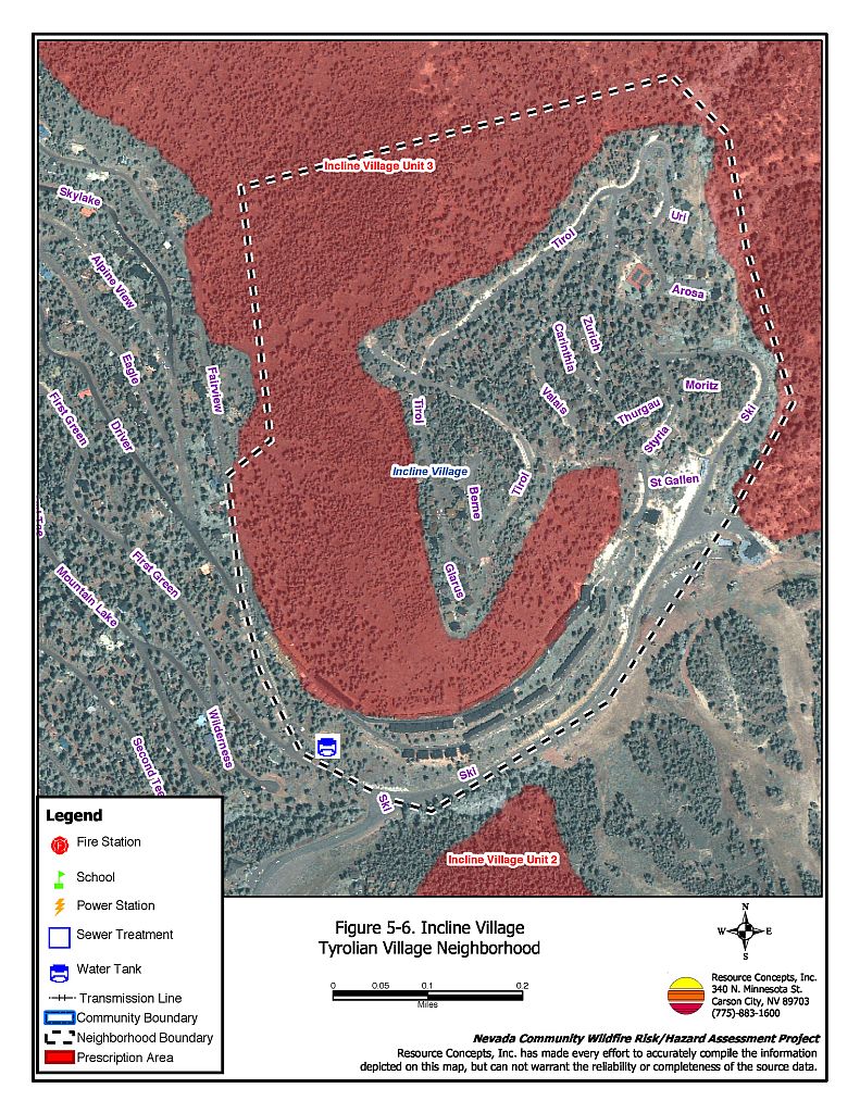
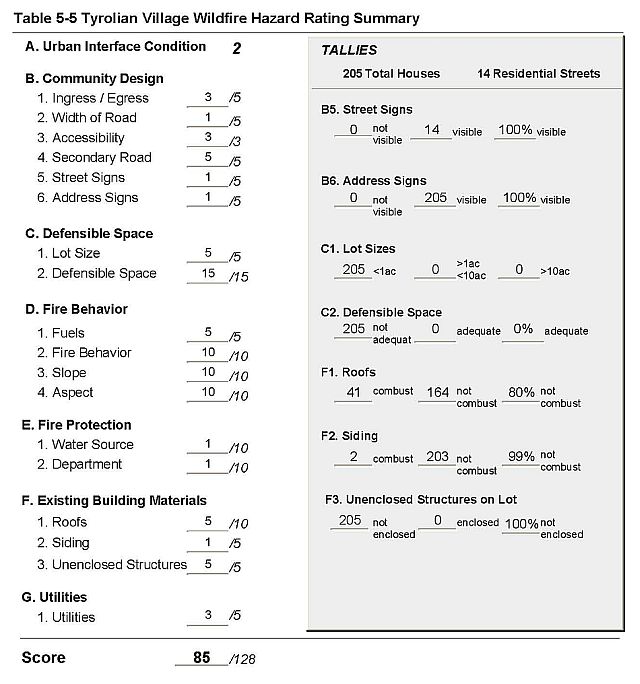
5.7 Tyrolian Village
Tyrolian Village is located in the northeastern portion of Incline Village (Figure 5-6). The area is on the western side of the Incline Creek drainage across from Diamond Peak Ski Resort, which is on the eastern side of the drainage. The risk assessment resulted in classifying Tyrolian Village in the Extreme Hazard category (85 points). This score is attributed primarily to close home spacing, limited access, inadequate defensible space, a high number of unenclosed structures, steep slopes, and heavy fuel loading. The community assessment rating sheet is provided as Table 5-5.
5.7.1 Community Design
There were 222 single-family residences observed in the assessment area. All of the lot sizes are less than one acre.
- Roads: Tyrol Drive is the only access into and out of the upper portion, and Bitterbrush Drive is the only access into and out of the lower portion of the neighborhood. The majority of roads have a greater than five percent grade, are narrow, have sharp bends and/or are dead-end streets. Many streets do not have adequate space to maneuver fire suppression equipment or for two vehicle passage.
- Signage: Street signs and residential address are present and clearly visible on all of the streets and homes in the neighborhood. The clear and visible signage will assist fire suppression personnel in locating residences during poor visibility conditions that may exist during a wildland fire.
- Utilities: Utilities are located below ground and do not pose an ignition risk.
5.7.2 Construction Materials
Over three-quarters (80%) of the residences have fire resistant roof materials such as composition roofing, metal, or tile. Nearly all (99%) of the residences have fire resistant siding materials.
All of the homes in the community have unenclosed balconies, porches, decks or other architectural features that create drafts and provide areas where sparks and embers can smolder and spread fire to the home.
Figure 5-6Incline Village Tyrolian Village Neighborhood |
 |
Table 5-5Tyrolian Village Wildfire Hazard Assessment Rating Sheet |
 |
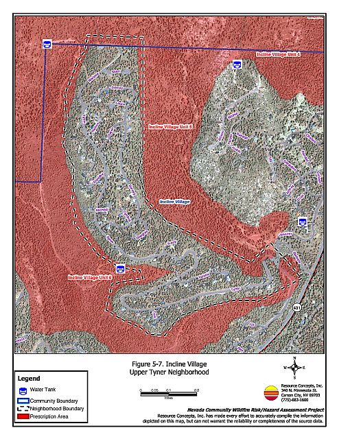
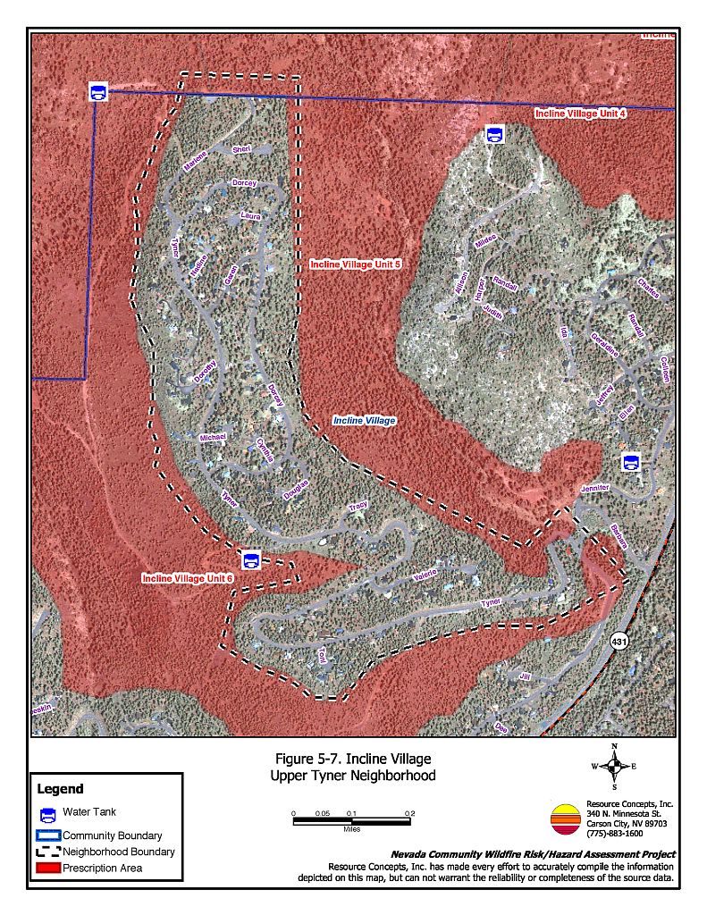
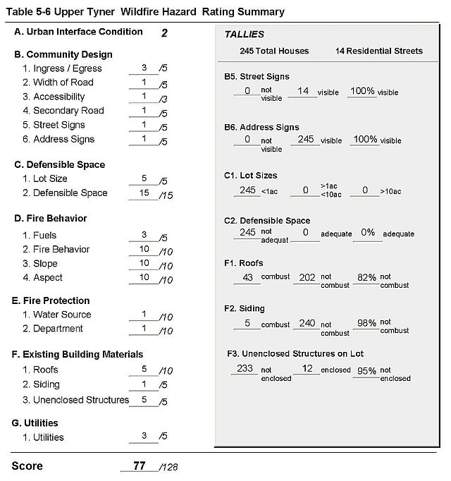
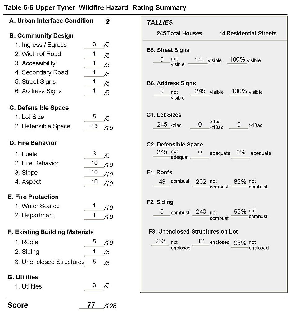
5.8 Upper Tyner
Upper Tyner is located in the northwestern portion of Incline Village (Figure 5-7). The neighborhood lies along both sides of a ridge between Wood Creek and Second Creek. The area surrounding the neighborhood is located on steep southwest and eastern facing slopes. Vegetation includes pine and fir intermixed with manzanita. The risk assessment resulted in classifying Upper Tyner in the Extreme Hazard category (77 points). This score is attributed primarily to inadequate defensible space, a high number of unenclosed structural features, close home spacing, steep slopes, and heavy fuel loading. The community assessment rating sheet is provided as Table 5-6.
5.8.1 Community Design
There were 245 single-family residences observed in the assessment area. All of the homes are on lots of one acre or less.
- Roads: Tyner Way is the only paved access into and out of this long, narrow neighborhood. The primary and secondary roads have a grade more than five percent, are narrow, and have sharp bends and/or are dead-end streets. Many streets do not have adequate space to maneuver fire engines or for two-vehicle passage.
- Signage: Street signs and residential addresses are present and clearly visible on all streets and residences in the neighborhood. The clear and visible signage will assist fire suppression personnel in locating residences during poor visibility conditions that may exist during a wildland fire.
- Utilities: Utilities are located below ground and do not pose an ignition risk.
5.8.2 Construction Materials
Over three-quarters of the residences (82%) have fire resistant roof materials such as composition roofing, metal, or tile while the remainder are wood shake. Nearly all (98%) of the homes have fire-resistant siding.
Nearly all of the homes in the community (95%) have unenclosed balconies, porches, decks or other architectural features that create drafts and provide areas where sparks and embers can smolder and spread fire to the home.
Figure 5-7Incline Village Upper Tyner Neighborhood |
 |
Table 5-6Upper Tyner Wildfire Hazard Assessment Rating Sheet |
 |
5.9 Incline Village Interior
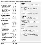
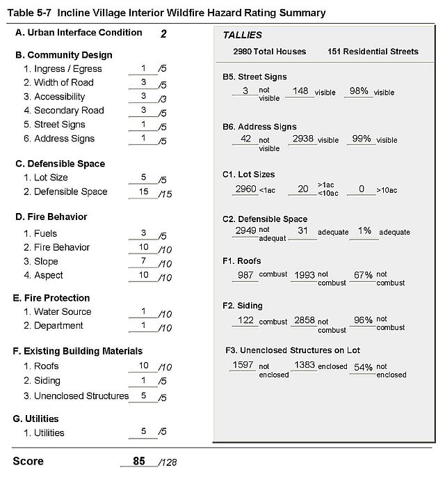
The Incline Village interior neighborhoods are in the central portion of Incline Village (Figure 5-1). The area is located in a second-growth stand dominated by Jeffrey pine with some white fir, incense cedar, and sugar pine. Undeveloped lots in the neighborhood have a heavy understory of brush consisting of manzanita, bitterbrush, snowbrush, white thorn, and huckleberry oak. The Hazard Assessment resulted in classifying the Incline Village Interior in the Extreme Hazard category (85 points). The primary risk factors for the area were inadequate defensible space, a high number of residences with wood shake roofs and unenclosed structures, and heavy fuel loadings. The Wildfire Hazard rating sheets are included as Table 5-7.
5.9.1 Community Design
There were 2980 single-family residences observed in the assessment area. The majority of the residences are on lots of less than one acre; 20 of the homes are on lots of between one and 10 acres.
- Roads: State Route 28, Tahoe Blvd., and SR 341 (Mount Rose Highway) are the primary roads leading into/out of the neighborhood. The primary and secondary roads are generally less than five percent grade. Most of the residential streets have adequate space to maneuver fire suppression equipment or for two-vehicle passage.
- Signage: Street signs are present on 98 percent of the secondary residential streets in the neighborhood. Residential addresses are clearly visible on 99 percent of the homes. Clear and visible signage assists fire suppression personnel in locating residences during poor visibility conditions that may exist during a wildland fire.
- Utilities: Utilities are located below ground and do not pose an ignition risk.
5.9.2 Construction Materials
Only 67 percent of the residences observed in the assessment area have fire resistant roof materials such as composition roofing, metal, or tile and the remainder are wood shake. The majority of the residences (96%) have fire resistant siding materials.
Just over half of the homes in the community (54%) have unenclosed balconies, porches, decks or other architectural features that create drafts and provide areas where sparks and embers can smolder and spread fire to the home.
Table 5-7Incline Village Interior Wildfire Hazard Assessment Rating Sheet |
 |