![]()
![]()
6.0 Crystal Bay
6.1 Crystal Bay Hazard And Risk Assessment
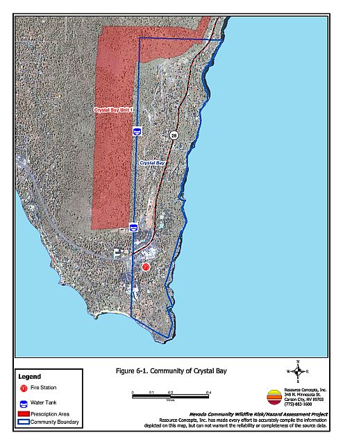
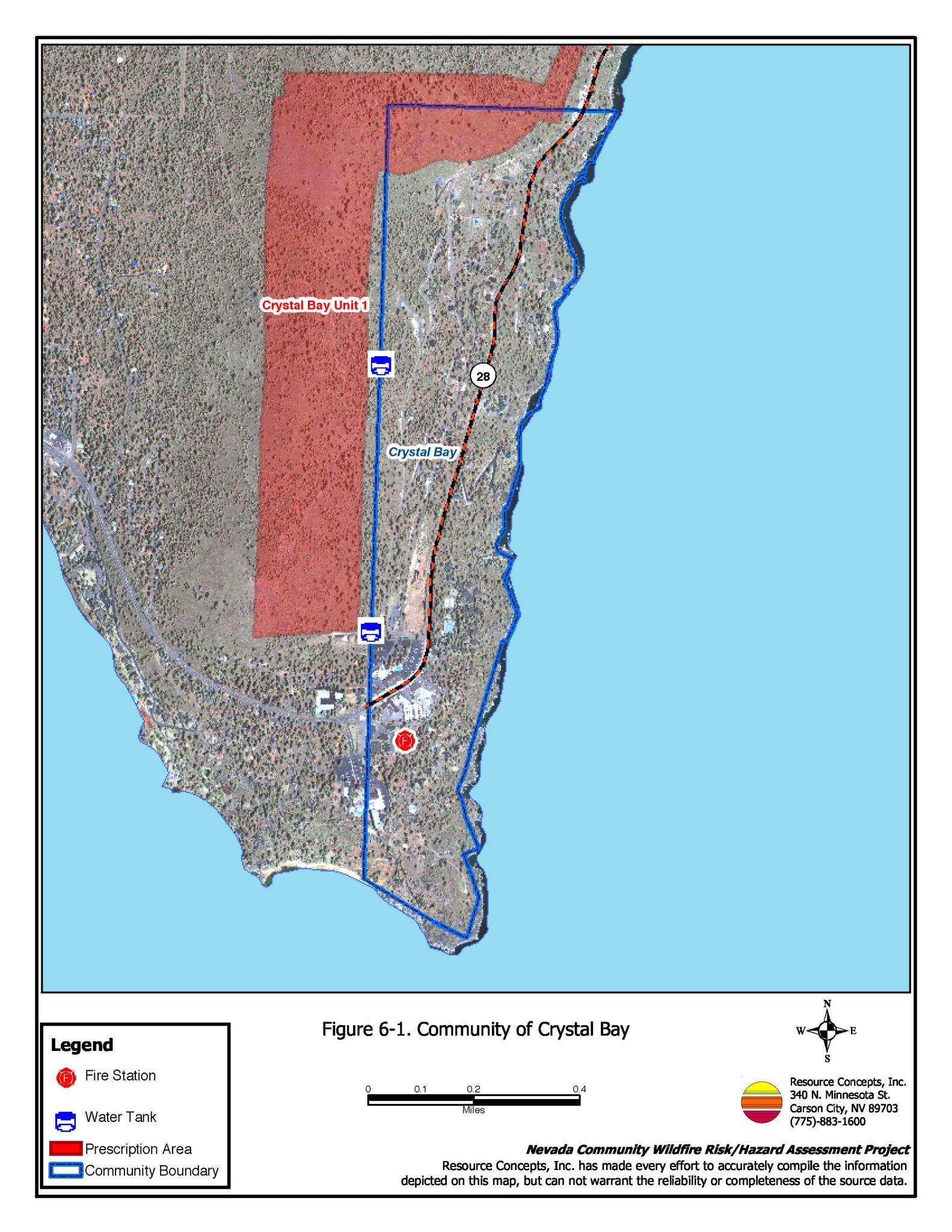
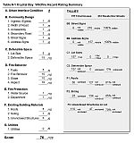
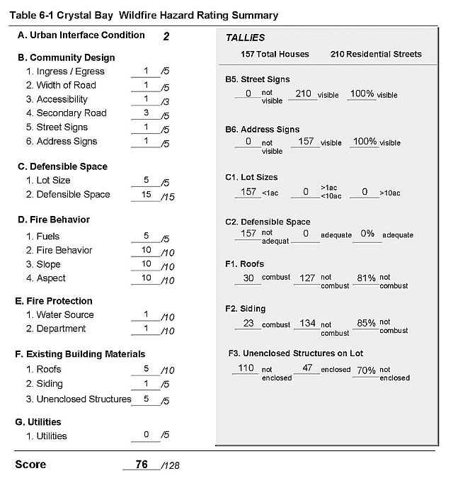
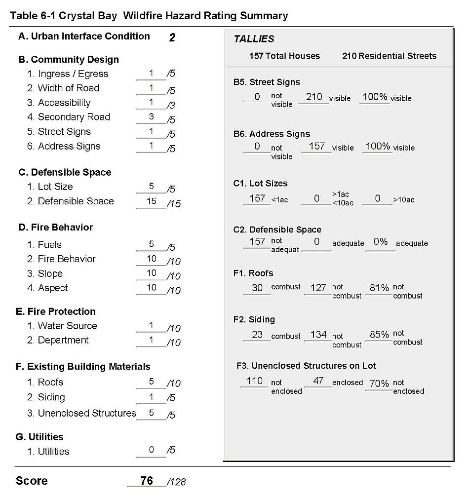
Crystal Bay is located at the northern tip of Lake Tahoe on the California/Nevada state line (Figure 6-1). The community is situated on east to southeast facing slopes and surrounded by a mix of old and second growth Jeffery Pine and white fir. Topography varies from steep to very steep. The risk assessment resulted in classifying Crystal Bay, as a whole, in the Extreme Hazard category (78 points). This score is attributed primarily to inadequate defensible space, heavy fuels, steep south facing slopes, combustible roof materials, and a high number of unenclosed architectural features. The community Hazard assessment rating sheet is provided as Table 6-1.
6.1.1 Community Design
The urban interface condition surrounding Crystal Bay is classified as an intermix condition. Structures are scattered throughout the wildland area. There is no clear line of demarcation between structures and wildland fuels along roads or back fences. There were 157 single-family dwellings observed in the assessment area. All of the homes are on lots of less than one acre in size.
- Roads: Tahoe Blvd. is the primary access road, passing through the center of the community. There are numerous secondary roads. Many of the roads are steep, narrow, have sharp bends and/or are dead-end streets. Many streets do not have adequate space to maneuver fire engines or for two-vehicle passage.
- Signage: Street signs are clearly visible on all of the residential streets, and residential addresses are present and clearly visible on all of the homes. The clear and visible signage will assist fire suppression personnel in locating residences during poor visibility conditions that may exist during a wildland fire.
- Utilities: The majority of the utilities in the Crystal Bay area are above ground. Overhead power lines pose an ignition risk because in several areas the utility rights-of-way are not properly maintained. Most residences have propane tanks and many do not have the minimum fuel clearance of 10 feet.
6.1.2 Construction Materials
Eighty-one percent of the residences have fire resistant roof materials such as composition roofing, metal, or tile. Roughly 85 percent of the residences have fire resistant siding materials.
Nearly three quarters of the homes in the community (70%) have unenclosed balconies, porches, decks or other architectural features that create drafts and provide areas where sparks and embers can smolder and spread fire to the home.
6.1.3 Defensible Space
The homes within the Crystal Bay area do not meet the defensible space landscape requirement to minimize damage to the home or loss during a wildfire. The terrain is generally steep, with heavy tree and shrub vegetation. In areas with topography and vegetation such as that in Crystal Bay, the recommend defensible space is at least 100 feet, and preferably 200 feet, of clearance. See Appendix D for defensible space details.
6.1.4 Factors that Affect Fire Behavior
Fuels in the Crystal Bay area are heavy. The tree layer is dominated by Jeffery pine with an understory shrub layer of manzanita, bitterbrush, whitethorn, and huckleberry oak. In some areas the huckleberry oak is 12 feet high and shrubs are closely spaced. In the higher elevations there are large stands of dead fir trees and many of the larger, older trees in the lower elevations are showing signs of decay in the trunks. Ground fuels consist of pine needles, squaw carpet, annuals, and grasses. Duff and needles are three inches deep in some areas. At the very northern edge of the community there is an old burn that has light shrub regrowth. This area is prone to avalanches and erosion in the winter, due to the lack of ground cover to hold soil and snow in place. Slopes in this area are about 60 percent, while overall slopes in Crystal Bay range from 10 to 70 percent. The aspects are eastern to southern.
The area may experience strong downslope winds during thunderstorms. Similarly, large fires in the basin during the fall may move downslope in the afternoon because of typical west to southwest winds. There are continuous fuels in close proximity and intermixed with structures. The composition of the fuels is conducive to crown fires or high intensity surface fires. The steep slopes, southern aspects, dense fuels, heavy duff, prevailing wind exposure and ladder fuels may reduce fire suppression effectiveness.
6.1.5 Worst Case Fire Behavior
There are two worst-case scenarios for the Crystal Bay area, equally hazardous. The first begins with a wildland fire in the Kings Beach (west of Crystal Bay) area during the summer months in the late afternoon. Prevailing winds could push a fire up and over the ridge down into the Crystal Bay community. Heavy fuels and steep slopes can quickly spread a fire. Narrow winding streets west of State Route 28 limit fire engine access. Several dead-end streets create a safety issue for suppression forces. There are several areas where structures are extremely close together where there will be an increased probability of structure ignition. There is a very high potential for crown fires and flame lengths could reach 5 to 10 feet in the understory. The rate of spread could reach 460 to 990 feet per hour.
In the second worst-case scenario, a fire started along the west side of SR 28 in the late afternoon in the summer could spread quickly uphill along the steep slopes to the west. The steep slopes and topography in concert with strong winds could create a chimney effect, drawing the fire up narrow drainages and streets through the community.
6.1.6 Risk Assessment
Crystal Bay is viewed as having a high risk of fire occurrence. The risk of ignition to the community is high and the risk of structure loss is extreme due to heavy vegetation, steep slopes, narrow steep roads; numerous unenclosed structures and shake roofs where embers can smolder and spread fire to the home; and poorly maintained utility lines and clearance around propane tanks. The fire history map indicates a large number of fire starts in the area. King’s Beach poses a hazard to Crystal Bay because of the potential for recreational fires that spark into adjacent wildland fuels.
6.2 Crystal Bay Risk Reduction Recommendations, Roles And Responsibilities
The responsibility to keep a community fire safe falls not only on the local fire department but also on the residents of the community, businesses, and local governments. General recommendations related to defensible space, fuel reduction, community preparedness, and public education, are included in Chapter 4.0, District-wide Assessment Results.
Fuel reduction treatments in the Crystal Bay area are the highest priority for the NLTFPD. The fuel reduction treatment is described in detail in Chapter 7.0, Recommended Hazard Mitigation Projects and briefly summarized below.
- Crystal Bay Unit 1 - Thinning and Brush Removal
- Establish a shaded fuel break within the wildland urban interface. The fuel break should be situated upslope to the west and north of private land in Crystal Bay for a width of one-quarter mile.
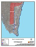
Figure 6-1Community of Crystal Bay |
 |
Table 6-1Crystal Bay Wildfire Hazard Assessment Rating Sheet |
 |