![]()
![]()
3.0 Description Of The Tahoe-Douglas Fire Protection District Service Area
3.1 Demographics, Location, Topography, And Climatic Data
The Tahoe-Douglas Fire Protection District is located in the Lake Tahoe Basin, on the Nevada side of the Lake. The district serves the area along the eastern and southeastern sides of Lake Tahoe, in Douglas County, Nevada. Nearly 72 percent of land area within the District is National Forest lands managed by the US Forest Service. A summary of land management acreage is provided in Table 3-1.
| Land Administrator | Acres |
|---|---|
| Nevada State | 1,348 |
| US Forest Sservice | 17,037 |
| Private/Municipal | 5,331 |
| Total | 23,716 |
| Source: TRPA and Douglas County GIS Databases | |
The area has a permanent population of approximately 7,500 residents; however the average daily population could be as high as 50,000 - 100,000 during peak winter and summer recreational periods. Skiing and snowboarding, camping, hiking, mountain biking, fishing and summer water sports, and the Lake Tahoe Shakespeare Festival at Sand Harbor, bring thousands of tourists from all over the world to the Lake each year. The Heavenly Valley Ski Resort is a large popular area for skiing in the winter months. During the summer the public and private beaches and recreation areas are filled with tourists.
Elevations within the Tahoe-Douglas Fire District range from 6,230 feet above mean sea level at Lake Tahoe to 9,591 feet at East Peak. Average annual precipitation is between 13 and 18 inches with the majority as snow during the winter months. Mean monthly temperature ranges between 32° F in January and 64° F in August.
3.2 Douglas County FEMA Disaster Plan
FEMA for Review. FEMA has reviewed the draft and requested revisions to the draft Plan. Douglas County has made the revisions and resubmitted the plan to FEMA for final approval. As of June 10, 2004, Douglas County has not received final approval from FEMA. The plan will go into effect once approval is received. Both TDFPD and the East Fork Fire and Paramedic District participated in the development of the Draft FEMA Disaster Plan
3.3 Wildfire History
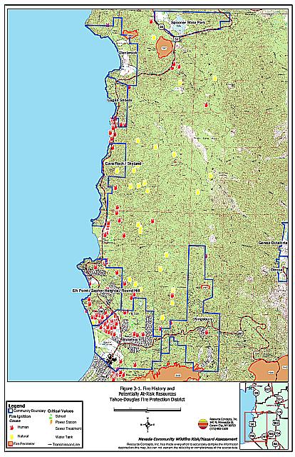
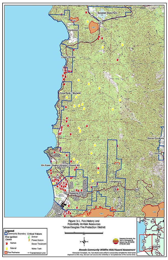
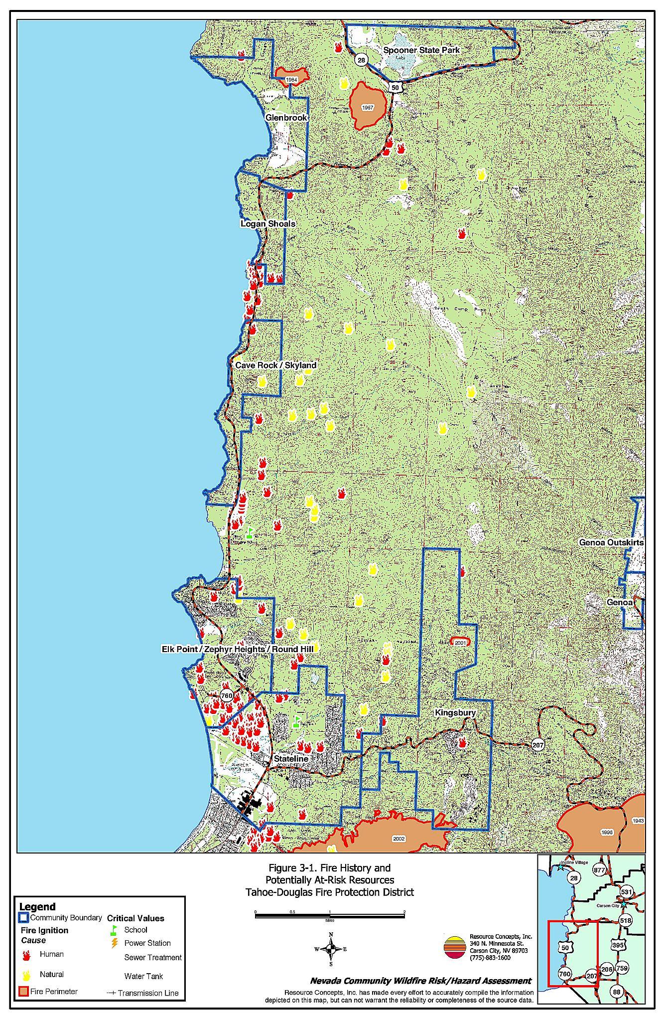
Wildfire and ignition history was compiled from GIS data provided by the US Forest Service Lake Tahoe Basin Management Unit. This data included ignition points and wildfire perimeters for the TDFPD. USFS staff members indicated that there are approximately 125 ignitions per year throughout the entire basin.
No fire perimeters are recorded in the database within the in the TDFPD. Local fire protection districts are not required to report incidents within their districts to the US Forest Service. Each district tracks it’s own data. TDFPD ignition and fire records are not mapped in a GIS, and are not included in this report. TDFPD staff reviewed this data and added major incidents where appropriate. Ignition data are categorized by source, either human or natural. As expected, many of the human ignition sources cluster around highways and recreational use areas, while natural ignitions tend to be located away from population centers
The historical data suggests that large, catastrophic wildfires can occur in the district. Ignitions are common but generally do not expand into a sizeable wildfire. A professional fire department and relatively short response times have been effective in keeping fires controllable and short-lived. Good access on paved roads helps shorten the response time. To date, fire suppression resources have been able to stop ignitions from becoming large fires.
Climate may also contribute to the lack of large fires. Though still fire prone, the seasonal window at which the fuels are most explosive is fairly short, and suppression resources are increased during that time.
Wildfire history in the TDFPD is illustrated on Figure 3-1.
3.4 Fire Ecology
The science of fire ecology is concerned with understanding how past fires have determined the present forest structure and species composition, and describing the role of fire in altering or maintaining forest structure and composition. A fire regime is defined as the frequency and severity of fire occurrence in a given forest type.
Some plant communities depend upon stand-replacing, high intensity fires. Lodgepole pine and fir forests evolved with the occurrence of infrequent, high-intensity, “stand destroying” wildfires that would have completely eliminated the existing forest stand. Few trees within the fire perimeter would have survived. The low frequency of fires in these plant communities would have allowed long periods of time for the accumulation of fuels and the reestablishment of vertical continuity (“ladder fuels”) and horizontal continuity (closed canopies) in the fuel strata. The resulting forest condition would have been conducive to the simultaneous combustion of all fuels during a single fire event.
Other plant communities such as Jeffrey pine forests evolved to burn frequently with low intensity. Under this historic fire regime, low-intensity surface fires would have reduced ground fuels of grasses and shrubs and would have suppressed regeneration of shade-tolerant white fir seedlings, leaving the mature Jeffrey pine trees protected by thick, fire-resistant bark unaffected. Forests with frequent fire occurrence would have had an open, “park-like” appearance with a sparse understory of grass or low shrubs. Though shaded by large, mature trees, the spacing between trees was sufficient to allow sunlight to reach the forest floor and encouraged regeneration of shade-intolerant species like ponderosa pine. Pockets of heavy fuels would have existed under these conditions, but their discontinuous nature reduced the likelihood that a fire would burn with enough intensity to affect mature trees. Frequent surface fires also would have removed accumulated dead and down woody fuels and the green “ladder fuels” that could otherwise have carried flames into the coniferous overstory, potentially provoking a catastrophic, stand-destroying crown fire.
The forest that regenerates with an infrequent, high-intensity crown fire regime is generally very dense and of a single age structure. This density often results in the exclusion of sunlight to the forest floor and subsequent recruitment of shade-tolerant species such as white fir, which contributes to extremely high fuel loadings in the understory.
Research by Dr. Alan Taylor, University of Pennsylvania Department of Geography, (Taylor et al. 2000) suggests that both forest types would have occurred naturally prior to early settlement in the Tahoe Basin but were separated by elevation at roughly the 8,000-foot contour. Above 8,000 feet, low temperatures and moisture high moisture conditions would have only infrequently allowed ignitions to grow into large fires. Below 8,000 feet, in warmer, drier areas, frequent ignitions would have occurred and resulted in consumption of the fuels. This constant consumption of fine fuels kept fuel loadings and fire intensity low.
Altered plant communities and fuel conditions and 20th century fire suppression policies have affected natural fire regimes. Areas that formerly burned with high frequency but low intensity (fires more amenable to control and intervention) now have large accumulations of unburned fuels, which once ignited, will burn at higher intensities.
The lower elevations of the Lake Tahoe Basin contain forest stands with highly altered fire regimes. The loggers of the 1860’s that worked in the region to satisfy the timber demands of the Comstock mines uniformly cut the native forests, originally characterized by uneven tree ages, wide spacings between trees in mature stands, and small openings created by other mortality. The forest that regenerated after this period of intensive logging activity developed into a uniform even-aged, closed canopy stand.
Gruell (2001) effectively illustrates this phenomenon in his book, Fire in Sierra Nevada Forests, A photographic interpretation of the ecological change since 1849. An example of paired photos taken from the same vantage point in Slaughterhouse Canyon north of Glenbrook, Nevada is shown below. The 1873 photo of an uncut forest clearly shows the forest floor and individual trees in the distance visible through the open canopy. The 1993 photo taken from the same alignment shows that the forest density is so high that individual trees can only be discerned at the forest edge. The current conditions, with a dense, almost continuous canopy and ladder fuels that reach to the forest floor are more reminiscent of high elevation forests that were naturally characterized by infrequent, high-intensity stand-replacing crown fires.
Slaughterhouse Canyon 1873

Slaughterhouse Canyon 1993

Today, most commercial and residential developments in the Tahoe Basin, i.e. those areas most needing protection from catastrophic wildfires, are concentrated in areas well below the 8,000-foot elevation where the fires would have been frequent, low-intensity, light-fuel clearing ground fires.
The recommendations in subsequent sections of this report outline tree densities and forest structures consistent with the forests seen in the historic photographs and are consistent with US Forest Service and Tahoe Regional Planning Agency management objectives to return Tahoe Basin forests to pre-European conditions.
3.5 Natural Resources And Other Features Potentially At Risk
3.5.1 Forest Health and the Lake Tahoe Watershed
The threat to watersheds is important to consider in the overall risk to Lake Tahoe. As the fire severity risk increases in the watershed, there is a greater risk of soil erosion damage in addition to a reduction in groundwater recharge.
The ability of a watershed to receive, store and transmit water is related to the geology, vegetation, and soil that characterizes the watershed. Fire has the potential to significantly alter vegetation and soil properties in a watershed, impacting critical hydrological functions such as interception, evapotranspiration, infiltration, soil moisture storage, and snow accumulation and melt. Impacts from alteration include increases in stream runoff, decrease in groundwater recharge, increase in erosion and sedimentation, and water quality degradation (Zwolinski 2000).
Vegetation plays an important role in rain and snow interception. A low severity fire that does not change the vegetation interception characteristics will have minimal impact on water yield. Fires that remove canopy foliage and litter material can result in considerable increases in runoff and soil erosion. Removal of vegetation canopy and duff allows more precipitation to reach the barren soil surface, resulting in increased soil surface erosion and degradation of water quality.
Infiltration can be reduced as heating from severe fires alters soil chemistry and can create hydrophobic layers (DeBano, 1981). Groundwater aquifer recharge can be hindered by these hydrophobic soil crust formations. Runoff and erosion are directly related to decreased infiltration and raindrop splash. The amount of sediment carried downstream, as a result, is dependent on soil properties and watershed geomorphology.
In the Lake Tahoe Basin, there are many areas with potentially threatening conditions in the forest. Tree density has increased consistently to the point where a wildfire occurring under a worst case scenario would potentially clear the watershed of trees and other vegetative cover. Such an event would likely render the watershed susceptible to severe flooding events and soil erosion of enormous magnitude.
3.5.2 Flora and Fauna
The Nevada Natural Heritage Program lists nine species within the Lake Tahoe Basin that are identified as federally threatened or endangered and protected by federal or state law. These species are summarized in Table 3-2.
| Species Name | Common Name | Status |
|---|---|---|
| Onchorhynchus clarki henshawi | Lahontan cutthroat trout | ESA |
| Accipiter gentilis | Northern goshawk | SP |
| Aplodontia rufa californica | Mono Basin mountain beaver | SP |
| Glaucomys sabrinus | Northern flying squirrel | SP |
| Lepus americanus tahoensis | Sierra Nevada snowshoe hare | SP |
| Martes americana | American marten | SP |
| Pinus washoensis | Washoe pine | CY |
| Rorippa subumbellata | Tahoe yellowcress | CE |
| Strix occidentalis occidentalis | California spotted owl | SP |
| CE = Listed as Critically Endangered by the state of Nevada CY = Protected as cactus, yucca or Christmas tree SP = State protected under NRS 501 |
||
3.5.3 Historical Sites
There are three sites listed on the National Register of Historical Places in Tahoe-Douglas Fire District. These sites could be destroyed during a wildland fire.
- Bliss Boat House located at 1951 Glenbrook Road, Glenbrook.
- Friday’s Station also known as Park Cattle Company Residence located adjacent to US 50 between Kingsbury Grade and Loop Road in Stateline.
- Lena N. Gale Cabin also known as Good Medicine Cabin located at 726 Cedar Street in Zephyr Cove.
- Lake Shore House located on Glenbrook Road in Glenbrook.
3.6 Previous Fire Hazard Reduction Projects
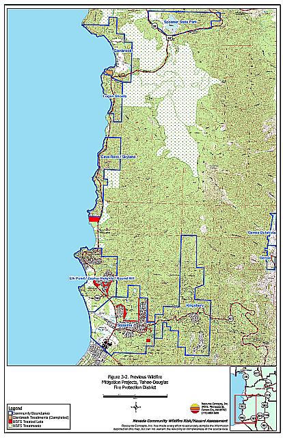
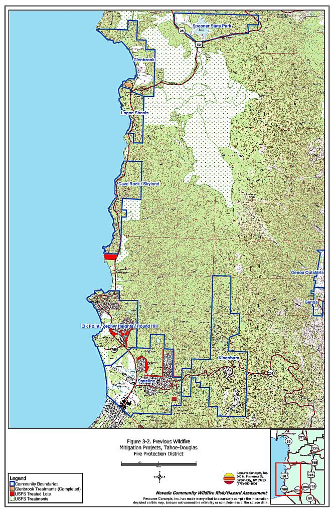
Currently, there are several chapters of the Nevada Fire Safe Council in the district: Glenbrook, Hidden Woods, and Lake Village. The Glenbrook Chapter of the Nevada Fire Safe Council is very active in developing solutions for wildfire hazard mitigation projects within their community. The Glenbrook community has developed a detailed list of mitigation projects and has begun implementation. Four community fuels reduction projects have been identified near Glenbrook; three have been completed and one is in progress. A community defensible space program is in practice, providing homeowners with options for removing material and creating defensible space around their homes.
The Tahoe Douglas Fire Protection District has recently begun to develop fuels mitigation projects with other communities in the District. The Hidden Woods subdivision has a project in progress with the USFS to treat the private land adjacent the National Forest boundary and to treat the National Forest land around the subdivision. TRPA is also participating in tree marking and with clearances for tree removal.
The US Forest Service and the State of Nevada have completed some fuels reduction treatments on federal and state lots within the Tahoe-Douglas communities. Through the Urban Lots Program, the US Forest Service has used the cut-pile-burn method to reduce fuels within communities. Large areas of National Forest land near Spooner Summit have been logged using helicopters. The USFS has also completed burning ground fuel piles that accumulated during the early 1990s, and plan to thin the residual stand in 2005. See Figure 3-2 for the location of these projects, in addition to recommended projects in this report.
3.7 Environmental Regulations Related To Vegetation Removal In The Lake Tahoe Basin
3.7.1 Projects on Private Land
Tree and vegetation removal on private land in the Lake Tahoe Basin is regulated by the TRPA Code of Ordinances.
- All live trees over 6” dbh need TRPA approval prior to removal unless they are dead or it is a fire suppression emergency.
- Trees over 24” dbh cannot be cut unless:
- The tree is in the urban interface areas (within 1,250 feet of a TRPA residential, commercial, or public service plan area boundary) and the TRPA determines that the tree would hinder defense from fire in an urbanized area;
- The TRPA agrees that the trees are severely insect-infested;
- Removal is for ecosystem management pending review by an interdisciplinary team and public review; or
- Removal of large snags is necessary to reduce extreme fuel loading.
- A Tree Removal Plan is required for the following circumstances:
- If a project calls for cutting more than 100 trees over 10” dbh AND it covers greater than 20 acres; OR
- If a project calls for cutting more than 100 trees over 10” dbh on land capability classes 1a, 1b, 1c, 2 or 3.
- A Tree Removal Plan will require, among other things, NEPA compliance.
- For projects not requiring a Tree Removal Plan, the TRPA requires a report from a qualified forester to cut any tree over 6” dbh.
The TRPA and the North Lake Tahoe Fire Protection District entered into a Memorandum of Understanding (MOU) to streamline the process for homeowners seeking to create defensible space and eliminate fire hazards. Pursuant to NRS 474.160, the NLTFPD has the authority and responsibility to remove fire hazards on private or public premises within the district. Through the MOU, the TRPA has delegated to the NLTFPD the authority to issue tree removal permits within 30 feet of structures within the district. A copy of the MOU is provided in Appendix C. Currently, the Tahoe-Douglas Fire Protection District does not have the same agreement and TRPA must process all tree removal requests.
3.7.2 Federal Projects
Projects that involve funding from a federal source or that are on land managed by a federal agency must comply with the National Environmental Policy Act (NEPA) and the Land and Resource Management Plan (Lake Tahoe Basin Management Unit, 1988) as amended by the Sierra Nevada Forest Plan Amendment, 2004, in addition to the TRPA Code of Ordinances described above. The National Environmental Policy Act enacted in 1969 requires Federal agencies to evaluate and disclose the effects of proposed actions on the human environment in a written statement that addresses:
- The environmental impact of the proposed action;
- Any unavoidable adverse environmental effects that may occur upon the implementation of the proposed action;
- Alternatives to the proposed action;
- The relationship between short-term uses of the human environment versus the maintenance and enhancement of long-term productivity; and
- Any irreversible and irretrievable commitments of resources that would be involved if the proposed action is put into effect.
Compliance with NEPA regulations begins with an internal screening process. If a preliminary review determines that the proposed action will not have any significant effect on the quality of the human environment, either individually or cumulatively, and that therefore neither an Environmental Assessment (EA) or an Environmental Impact Statement (EIS) is required (40 CFR 1508.4), then a categorical exclusion may exist, and no further environmental documentation is necessary or required. Some actions covered in an existing EA or EIS prepared by a Federal agency may not require analysis in a completely new document. Actions which are neither categorically excluded, already covered in an existing document, nor normally subject to EIS requirements, must be analyzed in an EA to determine if an EIS is in fact necessary or required.
An EA is a brief public document that discusses the need for, and alternatives to, a proposed action. The document provides sufficient evidence and analysis to support either a determination of no significant impacts, or a determination to prepare an EIS. If the EA confirms that the impacts of the proposed action are not significant, then a Finding of No Significant Impact (FONSI) is issued, and the NEPA review process is complete. If the EA reveals a significant impact, the proposed action cannot be approved unless it is either analyzed in an EIS, or modified to avoid significant impacts.
An EIS is a detailed document that requires extensive public involvement, facilitates interagency coordination, and provides the basis for permit approvals and other legal clearances that may be required for the proposed action. There are several mandatory steps in the EIS process, including public scoping meetings, publication of a notice of intent in the Federal Register, preparation and circulation of draft and final versions of the document, formal public hearings, and inclusion of public comments and responses to those comments in the final EIS.
It is anticipated that the fuel hazard mitigation projects proposed in this assessment (described in Chapter 11.0) will fall under a categorical exclusion or an EA. The US Forest Service LTBMU is currently following the Forest Service Handbook Interim Directive 1909.15-2003-1 and 1909.15-2003-2 (published in the Federal Register June 5, 2003). The Interim Directive contains several categorical exclusions that could apply to the proposed fuel hazard mitigation projects. Projects may be categorically excluded from an EA or EIS only if there are no extraordinary circumstances related to the project, including, but not limited to, threatened or endangered species, wetlands, archaeological sites or historic properties.
Figure 3-1Fire History and Potentially At-Risk Resources, Tahoe-Douglas Fire Protection District |
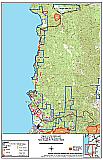 |
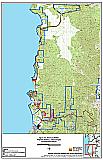
Figure 3-2Previous Wildfire Hazard Mitigation Projects, Tahoe-Douglas Fire Protection District |
 |