![]()
![]()
5.0 Cherry Creek
5.1 Risk and Hazard Assessment
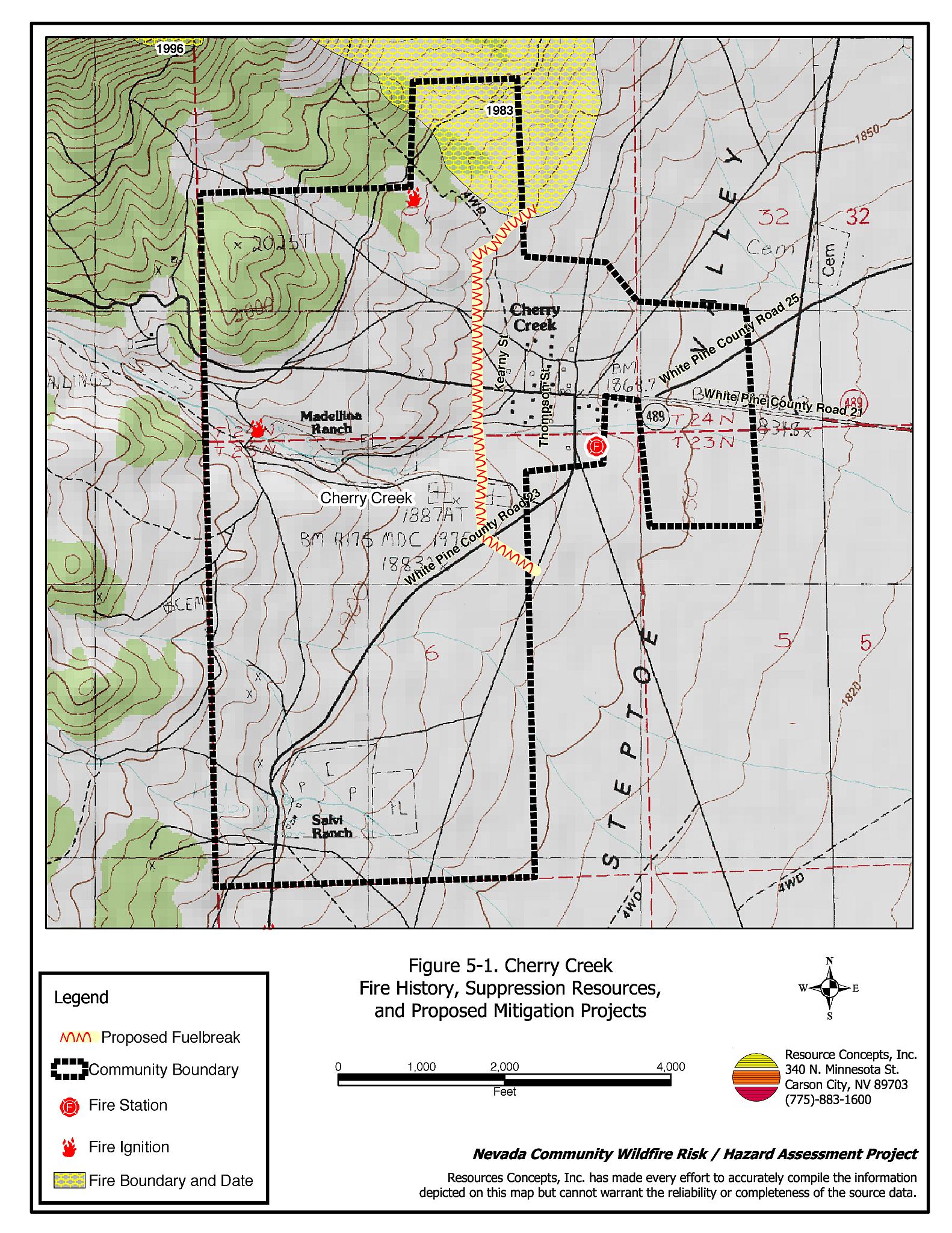
Cherry Creek is located in northern White Pine County along State Route 489, where White Pine County Roads 21 and 25 intersect (see Figure 5-1). State Route 489 intersects with US Highway 93 approximately 50 miles north of Ely, Nevada. Cherry Creek is situated in the lower reach of the canyon where Cherry Creek flows into Steptoe Valley. The risk/hazard assessment resulted in classifying Cherry Creek in the High Hazard Category (62 points). A summary of factors that contributed to the hazard rating is included in Table 5-3. Primary factors that determined the hazard rating for Cherry Creek were inadequate defensible space and building construction, potential for hazardous fire behavior related to topography and dense fuels, limited water sources within the community for fire suppression, and limited firefighting capabilities.
5.1.1 Community Design
The wildland-urban interface area around Cherry Creek can best be characterized as intermixed. There is no clear line of demarcation between wildland fuels and the residential structures in the community. Eight of the observed residences were on lots of less than one acre, twenty-three were on parcels of one to ten acres, and three parcels were greater than ten acres in size.
- Access: State Route 489 is the major transportation route through Cherry Creek. The highway is paved and at least 24 feet in width, providing adequate space for two-way vehicular travel and for fire suppression equipment to maneuver.
- Signage: Cherry Creek is a very small community. All of the homes are easily visible from the community access roads. There would be little chance of fire suppression personnel being unable to locate a particular structure that needed protection even under the low visibility conditions that occur during a wildfire.
- Utilities: Utilities were all above ground. Power lines have been properly maintained minimizing the possibility that arcing may start fires in nearby vegetation.
5.1.2 Construction Materials
About three-quarters of the homes in the interface are built with non-combustible or ignition resistant siding such as medium density fiberboard. Ninety-four percent of the homes had roofs of non-combustible material such as tile, metal, or composition. About one-third of the homes observed have unenclosed balconies, porches, decks, or other architectural features. Unenclosed features on homes can create drafty areas where sparks and embers can be trapped, smolder, ignite, and rapidly spread fire to the house.
5.1.3 Defensible Space
Approximately forty percent of the homes surveyed in Cherry Creek have landscaping that meets defensible space guidelines to protect the home from damage or loss during a wildfire.
5.1.4 Suppression Capabilities
Wildfire Protection Resources
Cherry Creek is protected by the Steptoe/Cherry Creek Volunteer Fire Department. At the time that interviews were conducted for this report, the VFD reported having twelve volunteer members. Additional resources are available from the BLM Ely Field Office, the NDF Ely Conservation Camp, and the Great Basin National Park Fire Department as described in Section 4.1.1. Table 5-1 summarizes cooperating partners and equipment available to respond to wildland fires in the Cherry Creek area.
| Type of Equipment | Amount of Equipment | Resource Location |
|---|---|---|
| Type 3 Engine Type 6 Engine Water Tender (2000 gallon) |
1 1 1 |
Steptoe/Cherry Creek VFD |
| Source: Chief John Evans, Steptoe/Cherry Creek VFD. | ||
Water Sources and Infrastructure
Water available for fire suppression in Cherry Creek includes:
- One developed well with a 1,000-gallon storage tank and filler pump at the fire station.
There are no hydrants or water storage tanks in Cherry Creek. There is one pond located on the Salvi Ranch south of Cherry Creek that could be used seasonally as a helicopter dip site with landowner permission.
Fire Protection Personnel Qualifications
All Steptoe/Cherry Creek VFD firefighters receive training to meet Nevada Division of Forestry Basic Wildland Firefighter standards. The Steptoe/Cherry Creek VFD does not utilize the Red Card system. Red Card certification is part of a fire qualifications management system used by many state and all federal wildland fire management agencies. This certification indicates that an individual is qualified to fight wildland fires.
Work Load
The Steptoe/Cherry Creek VFD responded to five calls in 2003; four wildland/brush fire calls and one structure fire.
Community Preparedness
White Pine County has an active Local Emergency Planning Committee and has adopted an emergency plan that includes a hazardous materials response plan. Cherry Creek is included in these County plans. The County also has an all-risk disaster response plan that is updated annually.
5.1.5 Factors Affecting Fire Behavior
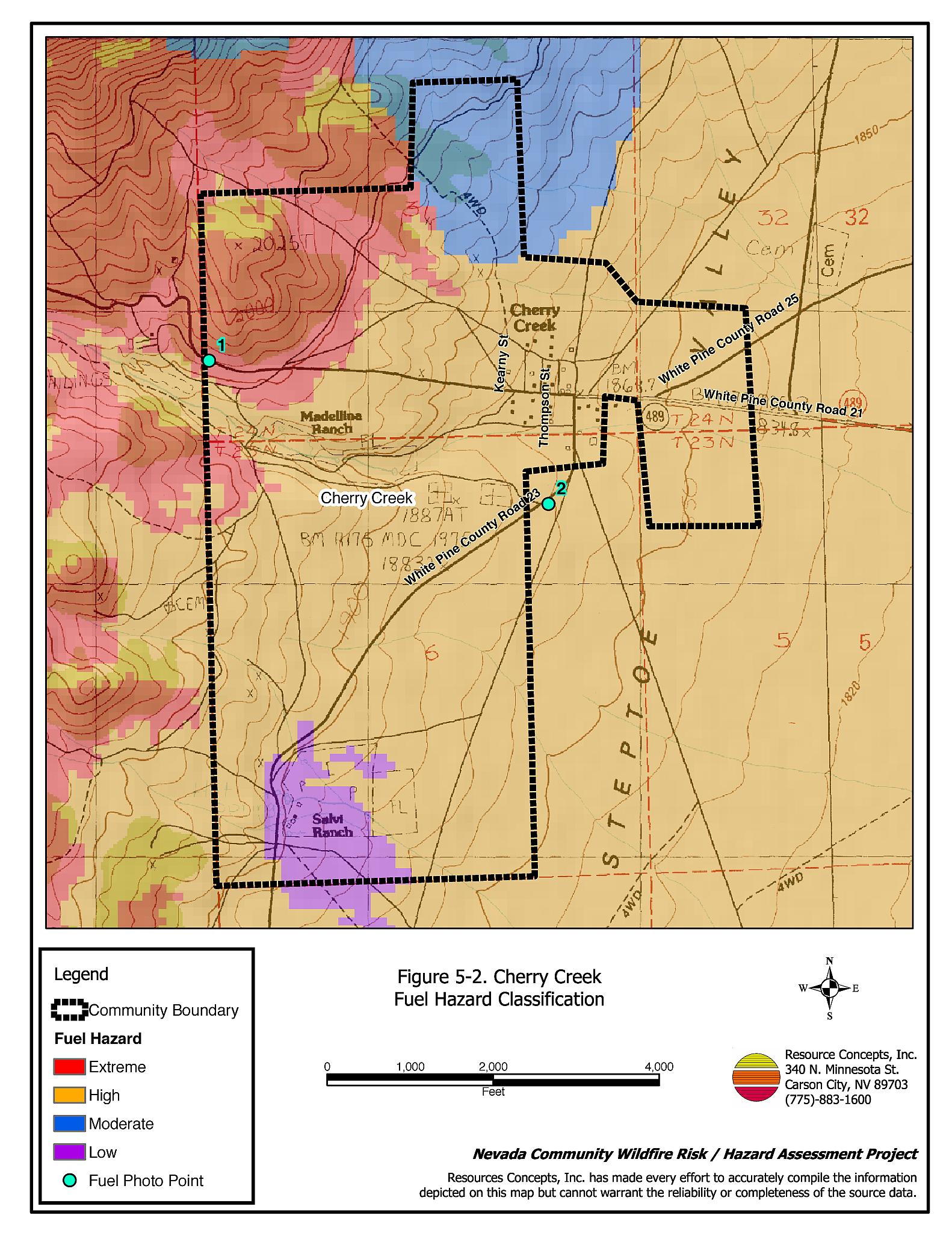
Vegetation, dead and down fuels, and topographic features contribute to the potential fire hazard around wildland-urban interface communities. The fuel hazards were mapped for Cherry Creek and fuel hazard photos were taken to provide additional information for the vegetation type descriptions (see Figures 5-2 and 5-3).
The vegetative fuel loading in the Cherry Creek interface area is generally light on the east side of the community and the lower reach of the Cherry Creek drainage. In these areas, the moderate to high hazard fuel load was estimated at two to three tons per acre. Fuels consist of a sagebrush and rabbitbrush shrub layer with some halogeton and cheatgrass as the ground fuels. In the west portion of the community (in the drainage), vegetative fuels consist of a tree layer of pinyon-juniper, a shrub layer of sagebrush and rabbitbrush, and an understory cheatgrass component. Fuel loading in this area was estimated at eight to fifteen tons per acre and considered an extreme fuel hazard. On the east of the community the terrain is fairly flat, but toward the west side of the community slopes range between eight and twenty percent.
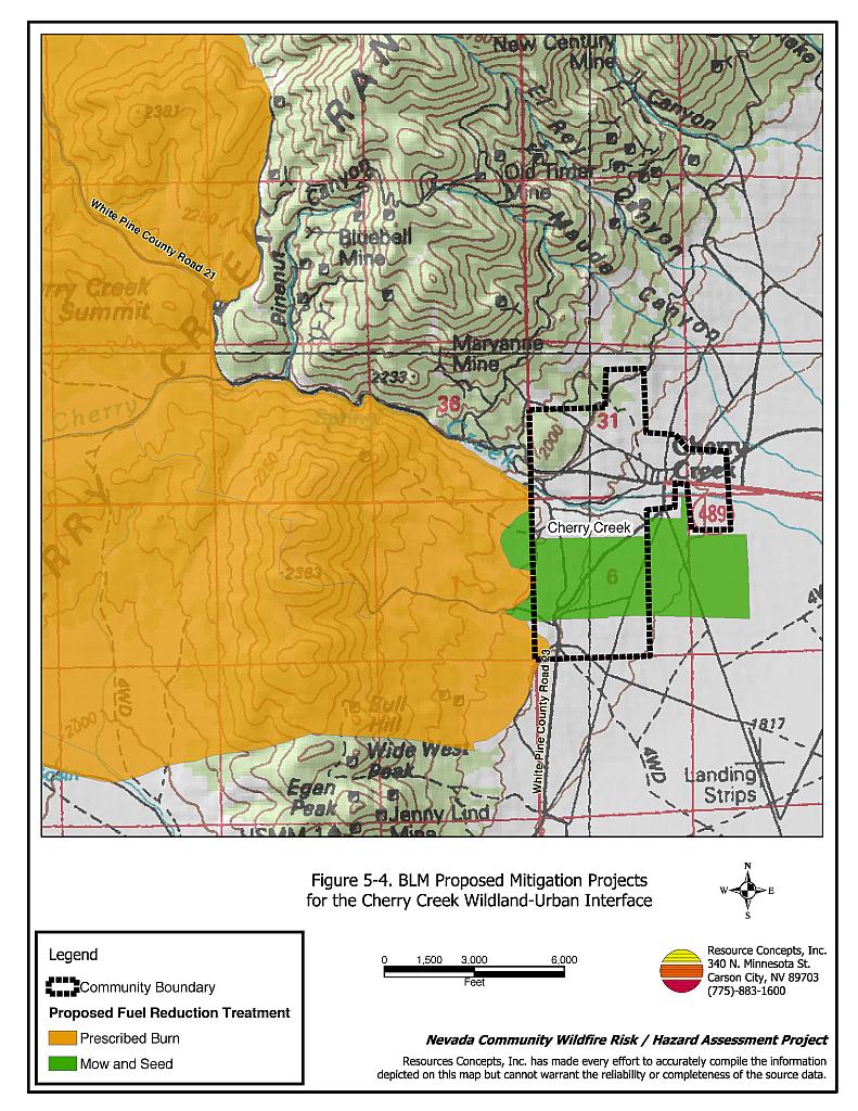
5.1.6 Planned Fire Hazard Reduction Projects
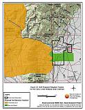
The Bureau of Land Management Ely Field Office is in the process of planning a fuel reduction treatment on the west side of the Cherry Creek community (Figure 5-4). Between sixty and eighty percent of the 13,388-acre project area is planned for prescribed burning and mowing treatments. The mosaic mowing and seeding treatment is proposed for the areas where BLM lands are adjacent to Cherry Creek private lands. The prescribed burning treatment is proposed further west of the community, and is scheduled to begin in 2005 and be completed in 2006. Either aerial or drill seeding is also proposed for the prescribed burn areas where cheatgrass is prevalent and very few perennial grasses are present in the understory (Coombs, pers. comm.).
5.1.7 Fire Behavior Worst Case Scenario
The worst-case scenario for Cherry Creek would be a lightning caused ignition west of the community that would be driven by high winds through the heavy pinyon-juniper fuels in the Cherry Creek drainage. In a high moisture year, high cheatgrass production would increase the risk of an ignition. Strong winds would rapidly spread fire into the shrub layer and eventually into the tree crowns and toward the adjacent homes. Given the long distances for agency resources to travel, the fire could exceed the capabilities of initial attack resources before help could arrive. The scenario would be worsened if mutual aid resources were unavailable due to fire activity in other areas or in the event of limited volunteer response.
5.1.8 Ignition Risk Assessment
Cherry Creek has a high ignition risk from dry lightning. There is a high potential for structure loss. In addition, there is extensive wildfire history in the area surrounding the community and a related history of lightning strikes. The primary ignition risk in Cherry Creek is lightning, although human caused ignitions can occur at any time.
5.2 Risk and Hazard Reduction Recommendations
The responsibility to keep a community fire safe falls not only on the local fire department, but also on residents, businesses, and local governments. Cherry Creek risk and hazard reduction recommendations focus primarily on maintaining defensible space, fire suppression training, and public education efforts.
5.2.1 Defensible Space Treatments
Defensible space treatments are an essential first line of defense for residential structures. Significantly reducing or removing vegetation within a prescribed distance from structures (30 feet to 200 feet depending upon slope and vegetative fuel type) reduces fire intensity and improves firefighter and homeowner chances for successfully defending a structure against an oncoming wildfire.
Property Owners Recommendations
- Remove, reduce, and replace vegetation around homes according to guidelines provided in Appendix E. This area should be kept:
- Lean: There are only small amounts of flammable vegetation.
- Clean: There is no accumulation of dead vegetation or other flammable debris.
- Green: Existing plants are healthy and green during the fire season.
- Maintain defensible space annually.
- Immediately remove any cleared vegetation or debris to an approved disposal site. This material dries quickly and poses a fire risk if left on site. Refer to the Defensible Space fact sheet in Appendix E for clearance guidelines.
- Keep the area beneath unenclosed porches and decks free of accumulated vegetation or other flammable debris. Enclose these areas wherever possible.
- Store woodpiles at least thirty feet from any structure.
- Clear all vegetation and combustible materials around propane tanks for a minimum distance of ten feet.
- Cheatgrass or other annual grasses that have become dominant within the defensible space zone should be mowed or treated with an application of pre-emergent herbicide prior to seed set.[2] Treatments may need to be repeated the following year to ensure that the seed bank of unwanted grasses has been depleted. Refer to Appendix E for approved seed mixes and planting guidelines that can be used in conjunction with removal of this annual grass.
- Remove brush growing within thirty feet of fences in the community.
- Install spark arrestors on chimneys.
5.2.2 Fuels Reduction Treatments
Fuel reduction treatments are applied on a larger scale than defensible space treatments. By permanently changing the fuel structure over large blocks of land to one of lower volume or reduced flammability (a fuel reduction treatment), the expected result in the event of a catastrophic wildfire would be one of reduced risk for uncontrolled spread through the treatment area. Reducing vegetation along roadways and driveways could reduce the likelihood of wildfire spreading across roads and improve firefighter access and safety for protecting homes.
White Pine County
- Reduce vegetation by mowing it to a height of not more than four inches for a distance of 25 feet from the edge of the pavement, along both sides of county roads. Seed or treat the cleared areas as necessary to control cheatgrass.
White Pine County and Property Owners
- In cooperation with BLM and NDF, create a 200-foot wide fuelbreak along the west edge of the community, with the approximate location provided on Figure 5-1. Thin shrubs in the fuelbreak to a canopy spacing of two times the height of the shrubs for a length of approximately 3,500 feet.
Electric Utility Company
- Maintain utility right-of-ways by removing trees from beneath power lines and thinning shrubs a minimum of fifteen feet around power line transformers.
5.2.3 Fire Suppression Resources
Adequate training, equipment, and water drafting supplies are critical to all firefighters, whether they are first responders, volunteer fire department personnel, or agency personnel. These matters are also of special importance to all communities, especially those located in remote portions of the county. The following recommendations are related to actions the county and fire departments can take to increase the quality of fire suppression response in their community.
Steptoe/Cherry Creek Volunteer Fire Department
- Volunteer firefighters should continue to receive State Fire Marshal structure firefighting training and annual wildland fire training, including the use of fire shelters.
- Meet annually with Nevada Division of Forestry and the Bureau of Land Management fire management personnel to review pre-attack plans, and to coordinate firefighting resources and response procedures.
White Pine County
- Coordinate with Nevada Division of Forestry to install a 10,000-gallon water storage tank at the Volunteer Fire Department fill station for structure protection.
- Coordinate with Nevada Division of Forestry to develop a management plan to upgrade fire suppression apparatus as necessary.
5.2.4 Community Coordination
Many of the most effective activities aimed at reducing the threat of wildfire for the Cherry Creek community require that individual property owners coordinate with each other and with local fire authorities. Defensible space, for example, is more effective in small communities when applied uniformly throughout entire neighborhoods. Public education and awareness, neighbors helping neighbors, and proactive individuals setting examples for others to follow are just a few of the approaches that will be necessary to meet the fire safe goals in the community. Disposal of biomass generated from defensible space and fuel reduction treatments can sometimes be most efficiently handled through community programs.
Property Owners
- Assure that address signs are visible from the road. Address characters should be at least four inches high, reflective, and composed of non-flammable material. Improving visibility of addresses will make it easier for those unfamiliar with the area to navigate under smoky conditions during a wildland fire.
- Form a local chapter of the Nevada Fire Safe Council. The Nevada Fire Safe Council proposes to work on solutions that reduce the risk of loss of lives and property from wildfires in Nevada’s communities. Through establishment of a local Chapter, communities become part of a large information-sharing network that receives notifications of programs and funding opportunities for fire mitigation projects such as those listed in this report. The Nevada Fire Safe Council will accept and manage grants and contracts on the Chapter’s behalf through its non-profit status. The Nevada Fire Safe Council provides assistance and support to communities to complete fire safe plans, set priorities, educate and train community members, and promote success stories of its members. To form a local Chapter or for more information, contact the Nevada Fire Safe Council, PO Box 2724, Carson City, NV 89702, telephone (775) 884-4455.
Steptoe/Cherry Creek Volunteer Fire Department
- Distribute copies of the publication “Living With Fire” to all property owners. This publication is available free of charge from the University of Nevada Cooperative Extension.
| Involved Party | Recommended Treatment | Recommendation Description |
|---|---|---|
| Property Owners | Defensible Space Treatments | Remove, reduce, and replace vegetation around homes (see guidelines in Appendix E). Keep defensible space lean, clean, and green. Mow and treat cheatgrass in areas around homes to deplete the seed bank. Reseed with species according to the seed mix in Appendix E. |
| Fuel Reduction Treatments | Construct a 200-foot wide fuelbreak on the west side of the community. | |
| Community Coordination | Assure addresses and street signs are clearly visible. Form a local chapter of the Nevada Fire Safe Council. |
|
| Utility Company | Fuel Reduction Treatments | Remove trees and thin shrubs beneath power lines and utility poles. Maintain a minimum of fifteen feet of clearance around power line transformers. |
| Steptoe/Cherry Creek VFD | Fire Suppression Resources | Provide structure fire training and obtain NDF wildland firefighter training for all volunteers. Meet with NDF and BLM annually to review the pre-attack plan for areas near Cherry Creek. |
| Community Coordination | Distribute copies of the publication “Living With Fire” to all property owners. | |
| White Pine County | Fuel Reduction Treatments | Create roadside clearances of 25 feet from both sides of roads. Construct a 200-foot wide fuelbreak on the west side of the community. |
| Fire Suppression Resources | Coordinate with NDF to upgrade equipment as necessary. Install a 10,000-gallon water storage tank for water drafting purposes. |
Table 5-3Cherry Creek Wildfire Hazard Rating Summary |
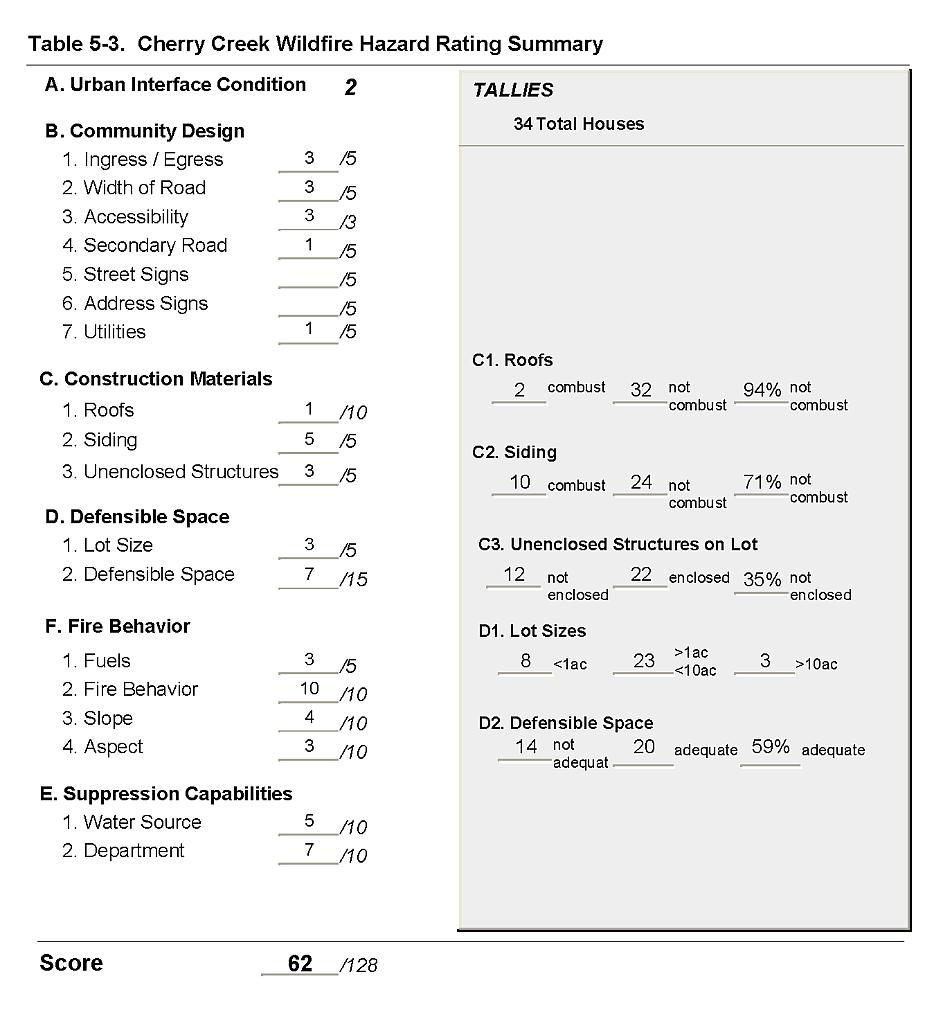 |
Figure 5-1Cherry Creek Fire History, Suppression Resources, and Proposed Mitigation Projects |
 |
Figure 5-2Cherry Creek Fuel Hazard Classification |
 |
Figure 5-3 Cherry Creek Fuel Hazard Photos
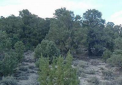
Photo Point 1. 4419015N, 679342E, 350°NW. The area west of Cherry Creek has pinyon-juniper trees with a shrub component of big sagebrush and rabbitbrush.The fuel load was estimated at eight to fifteen tons per acre and considered a high to extreme fuel hazard.
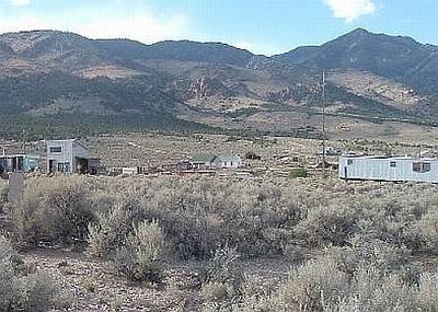
Photo Point 2. 4418489N, 680589E, 310°NW. Structures are scattered throughout wildland fuels. The vegetation east of Cherry Creek consists of big sagebrush and rabbitbrush, with halogeton and cheatgrass and was considered a high fuel hazard.
Figure 5-4BLM Proposed Mitigation Projects for the Cherry Creek Wildland-Urban Interface |
 |