![]()
![]()
6.0 Baker
6.1 Risk and Hazard Assessment
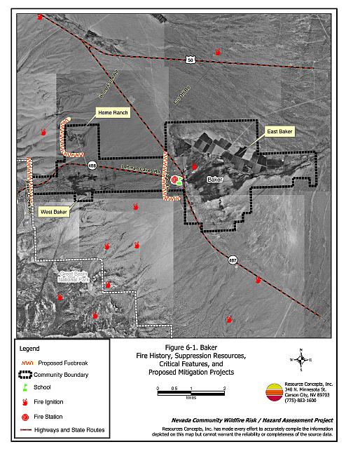
Baker is located in eastern White Pine County east of the Great Basin National Park, on State Route 487 south from US Highway 50 (see Figure 6-1). The community includes areas in the foothills of the Snake Range downslope and east toward the Sinks of Baker. The RCI Project Team evaluated three distinct areas of Baker to refine data interpretation and more accurately report conditions in the community. “East Baker” represents the east part of the community located on the flatlands. The “Home Ranch” area is centered at the junction of SR 487 and SR 488 (known to some as the School of the National Order). “West Baker” is south of the Home Ranch area and is situated adjacent to Great Basin National Park. The Baker community boundary and area delineations are shown in Figure 6-1.
The hazard assessment resulted in classifying Baker overall in the Moderate Hazard Category (51 points). A summary of factors that contributed to the hazard rating is included in Table 6-3. Primary factors that determined the hazard rating for Baker were the lack of street and address signage, inadequate defensible space, home construction factors, fire behavior factors, and limited fire suppression resources.
6.1.1 Community Design
The wildland-urban interface area around East Baker and Home Ranch can be characterized as the classic interface condition. There is a clear line of demarcation between building structures and wildland fuels. Wildland vegetation typically does not continue into the developed areas. Most homes were on parcels of between one and ten acres in size. The wildland-urban interface area around West Baker can be characterized as the intermix condition, where structures are scattered throughout the wildland area with no clear line of demarcation between wildland fuels and residences in the community. Twenty-one of the 23 residences are on parcels of greater than ten acres.
- Access: Major transportation routes through Baker include State Routes 487 and 488. These primary access roads are 24 feet wide, paved and have adequate turnaround space for fire suppression equipment. Secondary roads are typically between 20 and 24 feet in width with adequate space for maneuverability.
- Signage: In East Baker, nine of the streets are inadequately signed and none of the homes have clearly visible addresses. Clear and visible residential addresses and street signs are important to aid firefighting personnel in locating homes during low visibility conditions that occur during a wildland fire.
- Utilities: Utilities are all above ground. Power lines have not been properly maintained to minimize the possibility that arcing may start fires in nearby vegetation.
6.1.2 Construction Materials
Of the 93 homes observed in the interface area around Baker, 84 percent were built with non-combustible or ignition resistant siding materials. Ninety-one percent of homes had fire resistant roofing materials such as composition, metal, or tile.
6.1.3 Defensible Space
About three-quarters of the homes surveyed in Baker had landscaping that meets the minimum standard as defensible space. In East Baker 92 percent of the homes had adequate defensible space, in the Home Ranch area 88 percent of the homes met the defensible space guidelines, and in West Baker only 35 percent had adequate defensible space.
6.1.4 Suppression Capabilities
Wildfire Protection Resources
Baker is protected by the Baker Valley Volunteer Fire Department, which reported 25 members at the time the interviews were conducted for this report. Additional resources are available from the BLM Ely Field Office, the NDF Ely Conservation Camp, and the GBNP Fire Department. Table 6-1 lists wildfire suppression resources available from the Baker Valley VFD and other cooperating partners. The Baker VFD also lists Delta and Garrison Utah as mutual aid fire suppression resources, though they are both at least one hour away. The Baker VFD fire station is too small for storage of the existing apparatus. Additional room is needed in the station so that all equipment can be stored on-site and be available at all times.
| Type of Equipment | Amount of Equipment | Resource Location |
|---|---|---|
| Engine Type 6 Engine Type 2 Water Tender Type 2 |
2 2 1 |
Baker Volunteer Fire Department |
| Source: Bryon Morrison, Baker Valley VFD Fire Chief | ||
Water Sources and Infrastructure
Water availability for fire suppression in Baker includes the following:
- Community wells.
- 500 gpm hydrants within 1,000 feet of structures in East Baker and in the Great Basin National Park employee housing area west of the Baker community. No hydrants are available in Home Ranch and West Baker areas.
- One 100,000-gallon water storage tank.
- Two ponds are present in the Home Ranch area.
The water system operates by gravity and electrical pumps. A backup emergency generator runs the pumps in the event of an electrical power outage. Very recently in December of 2004, two dry hydrants were installed in the community. One dry hydrant has water capacity of 10,000-gallons and the other has a capacity of 15,000-gallons.
Fire Protection Personnel Qualifications
Baker Valley VFD fire protection personnel receive training to meet the State Fire Marshal entry-level firefighting, State Firefighter I and II standards for structure fires, and Nevada Division of Forestry and Park Service Basic Wildland Firefighter standards. Some of the Baker Valley VFD members have obtained a Red Card certification for wildland firefighting. Red Card certification is part of a fire qualifications management system used by many state and all federal wildland fire management agencies. This certification indicates that an individual is qualified to fight wildland fires. Bureau of Land Management and Nevada Division of Forestry fire protection personnel receive National Wildfire Coordinating Group training.
Work Load
The Baker Valley Volunteer Fire Department responded to thirty calls in 2003: 24 emergency medical calls and six wildland/brush fire calls.
Financial Support
Funding for the Baker Valley Volunteer Fire Department comes from local fundraising and from the NDF White Pine County Fire Protection District authorized under NRS 473.
Community Preparedness
White Pine County has an active Local Emergency Planning Committee and has adopted an emergency plan and a disaster plan. Baker is included in these County plans. The Baker Valley Volunteer Fire Department does not review development plans to ensure new development meets fire safety standards. The residents of Baker formed the Snake River Chapter of the Nevada Fire Safe Council in September of 2002.
6.1.5 Previous Fire Hazard Reduction Projects
During 2002 and 2003, the Nevada Division of Forestry Northern Region completed approximately eighteen acres of defensible space treatments around eight residences in Baker. Additional fuel reduction treatments are planned for the National Park boundary near residences in West Baker.
6.1.6 Factors Affecting Fire Behavior
The vegetative fuel loading and topography in the Baker interface area varies. The predominant wind direction in Baker is from the south/southwest in the late afternoon. The terrain in the East Baker area is relatively flat with east-facing slopes between two and four percent. In East Baker vegetative fuels consist primarily of big sagebrush, rabbitbrush, greasewood, halogeton, and cheatgrass. Fuel loading is estimated at two to three tons per acre and considered a low to moderate fuel hazard. The stream zone contains willows, Russian olive, poplar, and elm trees with fuel loads estimated at less than one ton per acre. Invasion of Russian thistle is prevalent throughout this part of Baker, which produces accumulations of dry tumbleweeds along fence lines and against buildings.
The Home Ranch area is situated at the base of the Snake Range foothills with slopes between eight and twenty percent. In this area of Baker, vegetative fuels are predominantly comprised of scattered pinyon pine and Utah juniper with a shrub layer of big sagebrush, rabbitbrush, and black sagebrush. Ground fuels are primarily cheatgrass and other annuals with some basin wildrye and other perennial grasses. The fuel load was estimated at four to six tons per acre and considered generally a low fuel hazard with scattered inclusions of high fuel hazard areas.
West Baker is situated slightly upslope of the Home Ranch area on east-facing slopes between eight and twenty percent. Fuels are dominated by the same species as in the Home Ranch area, but are present at greater densities. Fuel loads in this area were estimated at eight to fifteen tons per acre. In years of high precipitation, cheatgrass growth would be greater and there would be increased fuel loading throughout this area. The fuel hazard in West Baker was classified as high to extreme.
6.1.7 Fire Behavior Worst Case Scenario
The worst-case scenario for a major wildfire in the area surrounding Baker would occur during summer thunderstorms with dry lightning ignitions west of the community. The fire would be driven every direction by erratic winds from thunderstorms. Additional fuel loading from weedy annuals contributes to the wildfire hazard. That material would fuel the fire into adjacent shrub cover. Numerous ignitions from multiple lightning strikes would likely exceed initial attack resources, and additional resources are more than one hour away.
6.1.8 Ignition Risk Assessment
Baker was determined to have a high risk of ignition based on fire history in the area and the potential for increased fuel loading from cheatgrass and other annual weeds in high precipitation years. There is an extensive history of wildfire and lightning strikes on public lands surrounding the community. The primary risk of ignition in Baker is lightning, although human caused ignitions can occur at any time.
6.2 Risk and Hazard Reduction Recommendations
The responsibility to keep a community fire safe falls not only on the local fire department but also on residents of the community and local governments. Baker risk and hazard reduction recommendations focus on fire suppression resources and training, homeowner and agency efforts in defensible space and fuel reduction, and power line clearance and maintenance. Other recommendations pertain to community coordination and public education efforts that could be initiated to enhance fire safety.
6.2.1 Defensible Space Treatments
Defensible space treatments are an essential first line of defense for residential structures. Significantly reducing or removing vegetation within a prescribed distance from structures (30 feet to 200 feet depending upon slope and vegetative fuel type) reduces fire intensity and improves firefighter and homeowner chances for successfully defending a structure against an oncoming wildfire.
Property Owners Recommendations
- Remove, reduce, and replace vegetation around homes according to guidelines provided in Appendix E. This area should be kept:
- Lean: There are only small amounts of flammable vegetation.
- Clean: There is no accumulation of dead vegetation or other flammable debris.
- Green: Existing plants are healthy and green during the fire season.
- Maintain defensible space annually.
- Immediately remove cleared vegetation to an approved disposal site. This material dries quickly and poses a fire risk if left on site. Refer to the Defensible Space fact sheet in Appendix E for clearance guidelines.
- Keep the area beneath unenclosed porches and decks free of accumulated vegetation or other flammable debris. Enclose these areas wherever possible.
- Store woodpiles at least thirty feet from any structure.
- Clear all vegetation and combustible materials around propane tanks for a minimum distance of ten feet.
- Cheatgrass or other annual grasses that have become dominant within the defensible space zone should be mowed or treated with an application of pre-emergent herbicide prior to seed set.[3] Treatments may need to be repeated the following year to ensure that the seed bank of unwanted grasses has been depleted. Refer to Appendix E for approved seed mixes and planting guidelines that can be used in conjunction with removal of this annual grass.
- If pinyon and juniper trees are present within the defensible space areas, limb branches a minimum of four feet from the ground to reduce ladder fuels. Remove all dead and diseased branches, and duff from beneath the remaining trees. Prune tree branches to at least fifteen feet from chimneys, walls, and roofs of structures.
- Remove pine needles, leaves, and debris from roofs and rain gutters.
- If a resident decides to keep pinyon or juniper trees near the home for aesthetic reasons, no other trees or shrubs should be present within a minimum of thirty feet of the crown of the tree.
- Remove brush growing within thirty feet and grass within ten feet of fences in the community.
- Install spark arrestors on chimneys.
6.2.2 Fuels Reduction Treatments
Fuel reduction treatments are applied on a larger scale than defensible space treatments. By permanently changing the fuel structure over large blocks of land to one of lower volume or reduced flammability (a fuel reduction treatment), the expected result in the event of a catastrophic wildfire would be one of reduced risk for uncontrolled spread through the treatment area. Reducing vegetation along roadways and driveways could reduce the likelihood of wildfire spreading across roads and improve firefighter access and safety for protecting homes.
Power line corridors and transformer sites should be kept clear of flammable vegetation, as fires have been known to start from arcing power lines during windy conditions. Fire damage to power lines often creates power failures that can be especially dangerous in communities without a backup energy source. Energized power lines can also fall during a wildfire creating additional hazards for citizens and firefighters.
Property Owners
- Remove shrubs within ten feet and pinyon and juniper trees within 25 feet from each side of private driveways longer than 200 feet. Flammable fuels should be replaced with fire-resistant species such as crested wheatgrass, irrigated deciduous shrubs, wildflowers, lawn, or by seeding with an appropriate fire resistant seed mixture. Refer to Appendix E for recommended seed mixes and planting guidelines.
White Pine County
- Reduce vegetation by mowing it to a height of not more than four inches for a distance of 25 feet from the edge of the pavement, along both sides of county roads. Seed or treat the cleared areas as necessary to control cheatgrass.
- Remove trees within fifty feet of each side of roads in the West Baker area.
Property Owners, Nevada Division of Forestry, Bureau of Land Management, US Forest Service, and Great Basin National Park
Through cooperation with all involved landowners, create a series of 300-feet wide fuelbreaks along the west edge of East Baker, Home Ranch, and West Baker as shown in Figure 6-1. Fuelbreak specifications include thinning trees to a spacing of approximately ten trees per acre. Shrubs should be thinned to a canopy spacing of two times the height of the shrubs. Prune branches of remaining trees up to a height four feet above ground or no more than one-third the height of the tree. Broadcast seed the treated areas prior to tree removal with a seed mix developed for the area such as the one provided in Appendix E.
Baker Valley Volunteer Fire Department
- Clear or mow vegetation within ten feet of all fire hydrants in East Baker.
Electric Utility Company
- Maintain utility right-of-ways by removing trees from beneath power lines and thinning shrubs a minimum of fifteen feet around power line transformers.
6.2.3 Fire Suppression Resources
Adequate training, equipment, and water drafting supplies are critical to all firefighters, whether they are first responders, volunteer fire department personnel, or agency personnel. These matters are also of special importance to all communities, especially those located in remote portions of the county. The following recommendations are related to actions the county and fire departments can take to increase the quality of fire suppression response in their community.
Baker Valley Volunteer Fire Department and White Pine County
- Assure that volunteer firefighters receive annual wildland fire training including the use of fire shelters and State Fire Marshal structure firefighting training.
- Coordinate with the Nevada Division of Forestry for expanding the storage area in the existing fire station.
- Have an annually meeting with the Nevada Division of Forestry, the Bureau of Land Management, and Great Basin National Park fire management personnel to review pre-attack plans and to coordinate firefighting resources and response procedures.
6.2.4 Community Coordination
Many of the most effective activities aimed at reducing the threat of wildfire for the Baker area require that individual property owners coordinate with each other and with local fire authorities. Defensible space, for example, is more effective in small communities when applied uniformly throughout entire neighborhoods. Public education and awareness, neighbors helping neighbors, and proactive individuals setting examples for others to follow are just a few of the approaches that will be necessary to meet the fire safe goals in the community.
Property Owners
- Assure that address signs are visible from the road. Address characters should be at least four inches high, reflective, and composed of non-flammable material. Improving visibility of addresses will make it easier for those unfamiliar with the area to navigate under smoky conditions during a wildland fire.
Baker Valley Volunteer Fire Department
- Distribute copies of the publication “Living With Fire” to all property owners who live in Baker. This publication is free of charge and copies can be requested from the University of Nevada Cooperative Extension.
| Involved Party | Recommended Treatment | Recommendation Description |
|---|---|---|
| Property Owners | Defensible Space Treatments | Remove, reduce, and replace vegetation around homes according to the guidelines in Appendix E. Maintain defensible space as needed to keep the space lean, clean, and green. Mow and treat cheatgrass to deplete the seed bank. Reseed with species according to the seed mix in Appendix E. |
| Community Coordination | Improve address signage in Baker. Form a local chapter of the Nevada Fire Safe Council for the Baker area. |
|
| Fuel Reduction Treatments | Remove shrubs within ten feet and pinyon and juniper trees within 25 feet from each side of private driveways longer than 200 feet. Coordinate with agencies to construct 300-foot wide fuelbreaks. |
|
| Utility Company | Fuel Reduction Treatments | Remove trees and thin shrubs beneath power lines and utility poles. Maintain a minimum of fifteen feet of clearance around power line transformers. |
| Baker Valley Volunteer Fire Department | Fuel Reduction Treatments | Remove or mow vegetation within ten feet around fire hydrants to improve visibility and access. |
| Fire Suppression Resources | Continue to obtain annual wildland fire suppression training. | |
| Community Coordination | Distribute copies of the publication “Living With Fire” to all property owners. | |
| White Pine County Baker Valley Volunteer Fire Department |
Fuel Reduction Treatments | Continue roadside clearance of 25 feet from both sides of roads, and clearance of pinyon and juniper trees for 50 feet of both sides of roads in West Baker. Coordinate with landowners to construct fuelbreaks in East Baker, Home Ranch, and West Baker (Figure 6-1). |
| Fire Suppression Resources | Coordinate with the Nevada Division of Forestry to upgrade equipment add storage area to the existing fire station. | |
| Nevada Division of Forestry Bureau of Land Management Great Basin National Park US Forest Service |
Fuel Reduction Treatments | Coordinate with adjacent landowners to construct 300-foot wide fuelbreaks in East Baker, Home Ranch, and West Baker (Figure 6-1). |
Table 6-3Baker Wildfire Hazard Rating Summary |
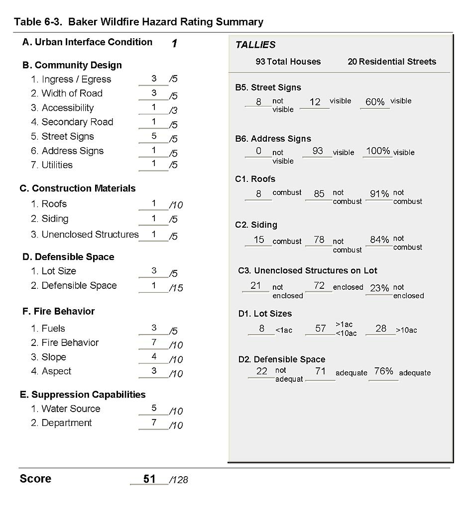 |
Figure 6-1Baker Fire History, Suppression Resources, Critical Features, and Proposed Mitigation Projects |
 |