![]()
![]()
7.0 Blue Diamond (Ward Mountain)
7.1 Risk and Hazard Assessment
In 2003, Resource Concepts, Inc. completed an assessment entitled “White Pine County Wildfire Risk Assessment and Fuel Reduction Plan for the communities of Ely, Blue Diamond, Ruth, and McGill” on behalf of White Pine County. The pertinent information for this report is summarized from the RCI Blue Diamond assessment.
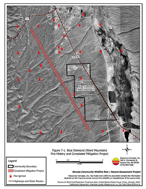
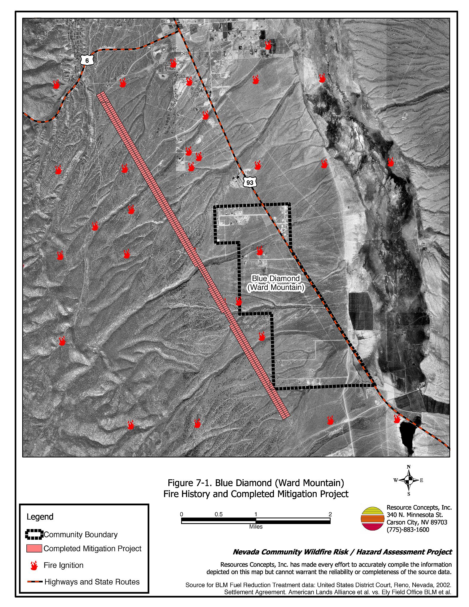
Blue Diamond (Ward Mountain) is a small community located approximately two miles south of Ely (see Figure 7-1). Forty-seven residences were evaluated during the Blue Diamond (Ward Mountain) assessment. The hazard assessment resulted in classifying Blue Diamond in the Moderate Hazard Category. Primary factors that determined the hazard rating for Blue Diamond were the presence of dead end roads, general lack of street and address signage, and the distance to water drafting supplies for fire suppression purposes.
7.1.1 Community Design
The Blue Diamond (Ward Mountain) interface area is characterized as an intermix wildland-urban interface condition. Structures are scattered throughout the wildland area with no clear line of demarcation between wildland fuels and residences in the community. A majority of the homes assessed were on parcels of two acres or more.
- Access: US Highway 93 (50) is the primary road connecting the Blue Diamond community with other communities in White Pine County. US Highway 93 is paved, at least 24 feet wide, and has adequate width for two-vehicle passage and fire suppression equipment to maneuver. Four dirt roads provide the primary access from the residences to the highway. Dead-end roads and driveways in the community may limit the ability for fire suppression equipment to maneuver or turn around.
- Signage: Street signs are present and visible along all streets in the Blue Diamond (Ward Mountain) community. Clear and visible residential addresses and street signs are important to aid firefighting personnel in locating homes during low visibility conditions that occur during a wildland fire.
- Utilities: Electrical utilities are underground. Above ground propane tanks are present and generally have the minimum of ten feet of vegetative clearance.
7.1.2 Construction Materials
All of the homes in the interface are built with non-combustible or ignition resistant siding such as medium density fiberboard and roofing of non-combustible material such as tile, metal, or composition. About one-quarter of the homes have unenclosed balconies, porches, decks, or other architectural features where sparks and embers can be trapped, smolder, ignite, and rapidly spreading fire to the house.
7.1.3 Defensible Space
All of the homes surveyed in Blue Diamond have landscaping that meets the minimum defensible space requirement to help protect the home from damage or loss during a wildfire.
7.1.4 Suppression Capabilities
Wildfire Protection Resources
The City of Ely Fire Department serves the Blue Diamond (Ward Mountain) area. Additional resources are available through other local volunteer fire departments, the BLM Ely Field Office, the NDF Ely Conservation Camp, and the GBNP Fire Department, as requested (Table 7-1).
| Type of Equipment | Amount of Equipment | Cooperating Partner |
|---|---|---|
| Engine Type 1 Engine Type 3 Engine Type 4 Water Tender |
1 1 1 4 |
City of Ely Fire Department |
| Engine Type 6 Water Tender 2000-gallon |
1 1 |
Lackawanna Volunteer Fire Department |
| Engine Type 1 Engine Type 2 Rescue Unit |
1 1 2 |
McGill Volunteer Fire Department |
| Engine Type 1 Engine Type 4 Water Tender Rescue Unit |
1 1 1 2 |
Ruth Volunteer Fire Department |
| Source: White Pine County Community Wildfire Hazard/Risk Assessment June 2003 (RCI) and subsequent interviews. | ||
Water Sources and Infrastructure
Very recently in November of 2004, two dry hydrants were installed in the community. One dry hydrant has water capacity of 10,000-gallons and the other has a capacity of 15,000-gallons.
Community Preparedness
White Pine County has an active Local Emergency Planning Committee and has adopted an emergency plan and a disaster plan. Blue Diamond (Ward Mountain) is included in these County plans. The residents of Blue Diamond formed the Ward Mountain Chapter of the Nevada Fire Safe Council in September of 2002.
7.1.5 Previous Fire Hazard Reduction Projects
The Bureau of Land Management Ely Field Office implemented a fuel reduction treatment on the west side of the Blue Diamond (Ward Mountain) community along Pole Line Road in 2004 (Figure 7-1). The treatment area encompasses 345 acres and included lop and scatter, slashing, and chipping operations. The tree cutting operation was completed on 263 acres. Eighty-two acres were either hand-cut by BLM crews or cut with a shear owned by the BLM. The treatment involved thinning dense stands of pinyon and juniper trees and leaving a density of approximately 25 of the larger trees per acre. Trees and slash were processed into chips and transported off site.
During the summer/fall of 2004, the Nevada Division of Forestry Northern Region completed approximately eight acres of defensible space around seven residences in the Blue Diamond (Ward Mountain) community. An additional twenty acres of fuel reduction treatments were completed around the Ranger Station, campgrounds, and day use areas at the Ward Charcoal Ovens State Historic Park.
7.1.6 Factors Affecting Fire Behavior
The Blue Diamond (Ward Mountain) community is situated on an east-facing alluvial fan with slopes between two and eight percent. Overstory vegetation is comprised primarily of juniper with lesser amounts of pinyon. The understory fuels include black sagebrush and associated native grasses. The steep slopes west of the community were considered an extreme fuel hazard. Steeper slopes occur within many drainages that dissect the fan. Fuel density is typically higher along the drainages consisting of Wyoming big sagebrush, black sagebrush, and grasses. Further east and lower on the alluvial fan, the pinyon pine and juniper cover decreases and black sagebrush becomes increasingly dominant. Many homes in Blue Diamond were built in or near the transition zone between juniper and black sage dominated lands where the fuel hazard was considered low to high.
7.1.7 Fire Behavior Worst Case Scenario
In Blue Diamond (Ward Mountain) the worst-case scenario would be a fire starting on a summer day south or southwest of the community. Such a fire would be driven by predominant south/southwest winds through the grass and shrub layer toward homes. The rate of spread would be dependent upon the wind speed and topography. Juniper and black sagebrush vegetation types would likely require strong, continuous winds to push a fire toward existing homes. Flame lengths and rate of spread would be faster along the steep, densely vegetated drainages.
7.2 Risk and Hazard Reduction Recommendations
The responsibility to keep a community fire safe falls not only on the local fire department but also on residents of the community and local governments. Recommendations for Blue Diamond homeowners focus on the maintenance of defensible space. Fire suppression resource recommendations include obtaining funding for the development of water sources such as tanks and a backup generator for water delivery and obtaining funding for the eventual development of a hydrant system for the community with wells and tanks.
The RCI Project Team Fire and Resource Specialists returned to Blue Diamond (Ward Mountain) during the August 2004 assessment to determine if earlier recommendations had been implemented. The Pole Line Road project was completed at the time of the assessment. No other recommendations had been implemented.
7.2.1 Defensible Space Treatments
Defensible space treatments are an essential first line of defense for residential structures. Significantly reducing or removing vegetation within a prescribed distance from structures (30 feet to 200 feet depending upon slope and vegetative fuel type) reduces fire intensity and improves firefighter and homeowner chances for successfully defending a structure against an oncoming wildfire.
Property Owners Recommendations
- Remove, reduce, and replace vegetation around homes according to guidelines provided in Appendix E. This area should be kept:
- Lean: There are only small amounts of flammable vegetation.
- Clean: There is no accumulation of dead vegetation or other flammable debris.
- Green: Existing plants are healthy and green during the fire season.
- Maintain defensible space annually.
- Immediately remove cleared vegetation to an approved disposal site. This material dries quickly and poses a fire risk if left on site. Refer to the Defensible Space fact sheet in Appendix E for clearance guidelines.
- Keep the area beneath unenclosed porches and decks free of accumulated vegetation or other flammable debris. Enclose these areas wherever possible.
- Store woodpiles at least thirty feet from any structure.
- Clear all vegetation and combustible materials around propane tanks for a minimum distance of ten feet.
- Cheatgrass or other annual grasses that have become dominant within the defensible space zone should be mowed or treated with an application of pre-emergent herbicide prior to seed set. Treatments may need to be repeated the following year to ensure that the seed bank of unwanted grasses has been depleted. Refer to Appendix E for approved seed mixes and planting guidelines that can be used in conjunction with removal of this annual grass.
- Remove brush growing within thirty feet and mow grass within ten feet of fences in the community.
- Install spark arrestors on chimneys.
- Obtain copies of the publication “Living With Fire.” This publication can be obtained free of charge from the University of Nevada Cooperative Extension.
7.2.2 Fuels Reduction Treatments
Fuel reduction treatments are applied on a larger scale than defensible space treatments. By permanently changing the fuel structure over large blocks of land to one of lower volume or reduced flammability (a fuel reduction treatment), the expected result in the event of a catastrophic wildfire would be one of reduced risk for uncontrolled spread through the treatment area. Reducing vegetation along roadways and driveways could reduce the likelihood of wildfire spreading across roads and improve firefighter access and safety for protecting homes. The location of the completed fuel reduction project in the Blue Diamond area is shown on Figure 7-1.
Bureau of Land Management and US Forest Service
- Maintain the Pole Line Road fuel reduction treatment on the west side of the Blue Diamond community.
7.2.3 Fire Suppression Resources
Adequate training, equipment, and water drafting supplies are critical to all firefighters, whether they are first responders, volunteer fire department personnel, or agency personnel. These matters are also of special importance to all communities, especially those located in remote portions of the county. The following recommendations are related to actions the county and fire departments can take to increase the quality of fire suppression response in their community.
White Pine County, and Nevada Division of Forestry
- Develop water storage of at least 10,000 to 15,000 gallons for fire protection. Install water outlets with fire hose threads on the new water development for filling water tenders and engines.
7.2.4 Community Coordination
Many of the most effective activities aimed at reducing the threat of wildfire for the Blue Diamond (Ward Mountain) community require that individual property owners coordinate with each other and with local fire authorities. Defensible space, for example, is more effective in small communities when applied uniformly throughout entire neighborhoods. Public education and awareness, neighbors helping neighbors, and proactive individuals setting examples for others to follow are just a few of the approaches that will be necessary to meet the fire safe goals in the community.
Property Owners
- Assure that address signs are visible from the road. Address characters should be at least four inches high, reflective, and composed of non-flammable material. Improving visibility of addresses will make it easier for those unfamiliar with the area to navigate under smoky conditions during a wildland fire.
White Pine County
- Require all future development in the Blue Diamond (Ward Mountain) area to comply with the most stringent fire code and standards with regards to construction materials, road design, defensible space, and water supply systems. The County must assure that fire safe community recommendations are adopted for the Blue Diamond Community. An example of fire safe community standards is included in Appendix F.
City of Ely Fire Department
- Distribute copies of the publication “Living With Fire” to all property owners who live in Blue Diamond (Ward Mountain). This publication is free of charge. Copies can be requested from the University of Nevada Cooperative Extension.
| Involved Party | Recommended Treatment | Recommendation Description |
|---|---|---|
| Property Owners | Defensible Space Treatments | Remove, reduce, and replace vegetation around homes according to the guidelines in Appendix E. Maintain defensible space as needed to keep the space lean, clean, and green. Mow and treat cheatgrass to deplete the seed bank. Reseed with species according to seed mix in Appendix E. |
| Community Coordination | Assure addresses are visible from the road. | |
| Bureau of Land Management US Forest Service |
Fuel Reduction Treatments | Maintain the Pole Line Road fuel reduction project. |
| White Pine County Nevada Division of Forestry |
Fire Suppression Resources | Develop water storage for fire suppression drafting sources. |
| Ely Fire Department | Community Coordination | Distribute copies of the publication “Living With Fire” to all property owners who live in Blue Diamond (Ward Mountain). |
| White Pine County | Community Coordination | Require all future development in Blue Diamond (Ward Mountain) to comply with the most stringent fire code and standards with regards to construction materials, road design, defensible space, and water supply systems. |
Figure 7-1Blue Diamond (Ward Mountain) Fire History and Completed Mitigation Project |
 |