8.0 Cold Creek
8.1 Cold Creek Risk and Hazard Assessment
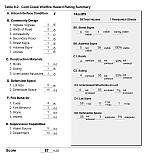
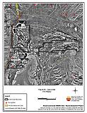
Cold Creek is located at the end of State Route 892, about ten miles north of Strawberry (see Figure 8-1). Fifty-nine seasonal and full-time residences were assessed in wildland-urban interface areas of the Cold Creek community. The hazard assessment resulted in classifying Cold Creek in the Moderate Hazard Category (57 points). A summary of factors that contributed to the hazard rating is provided in Table 8-2. Primary factors that determined the hazard rating were limited fire suppression resources, inadequate defensible space, and little to no address or street signage.
8.1.1 Community Design
The Cold Creek wildland-urban interface area is characterized as a classic interface condition where residences border wildland fuels with a clear line of demarcation between the fuels and the residences. Lot sizes are primarily less than one acre.
- Access: State Route 892 is the primary road connecting Cold Creek with other communities in White Pine County. The highway is paved and at least 24 feet wide, an adequate width for two-vehicle passage and fire suppression equipment to maneuver.
- Signage: Street signs and addresses were not present in Cold Creek. Clear and visible residential addresses and street signs are important to aid firefighting personnel in locating homes during low visibility conditions that occur during a wildland fire.
- Utilities: Electric utilities are above ground in Cold Creek. Most of the power line corridors have been properly maintained.
8.1.2 Construction Materials
Four of the homes assessed were constructed of flammable siding. While many older mobile homes are extremely flammable, especially when skirting is absent, most of the homes in Cold Creek were travel-type trailers or newer mobile homes constructed of medium density fiberboard, an ignition resistant material.
8.1.3 Defensible Space
A majority of the homes surveyed in Cold Creek do not have landscaping that meets the minimum defensible space requirement to help protect the home from damage or loss during a wildfire.
8.1.4 Suppression Capabilities
Wildfire Protection Resources
Cold Creek has no local fire protection. Communities with no local fire protection are at higher risk of damage and property loss from wildfires than communities that have such resources. The BLM Ely Field Office and the NDF Ely Conservation Camp are available to respond to a wildfire with resources detailed in section 4.1.1.
Water Sources and Infrastructure
Water for fire suppression is available from private wells or ranch ponds. The Nevada Division of Forestry also installed a dry hydrant with 10,000-gallon water storage capacity in the community in the fall/winter of 2004.
8.1.5 Previous Fire Hazard Reduction Projects
The Nevada Division of Forestry Northern Region implemented a twenty-one acre fuel reduction treatment around residences in Cold Creek during the fall/winter of 2004. Shrub density was reduced using mechanical mastication equipment. The fuel reduction area was also treated with Plateau and seeded with “Roadway” crested wheatgrass. NDF also provided “Living with Fire” brochures to residents.
8.1.6 Factors That Affect Fire Behavior
The northwest portion of Cold Creek consists of a small neighborhood of travel trailers. The terrain is flat throughout the community. Scattered ranch properties are located in the central and south portions of the community. Predominant winds are from the southwest, although summer thunderstorms can cause erratic winds. Vegetation surrounding the community consists of one to three-foot tall big sagebrush and rabbitbrush, with an understory of cheatgrass, bottlebrush squirreltail, and Indian ricegrass. Fuel loads were estimated at two tons per acre. West of Cold Creek the wildland vegetation is dominated by pinyon and juniper with a sagebrush-rabbitbrush shrub layer and an understory composed of cheatgrass, bottlebrush squirreltail, and Indian ricegrass. Fuel loads in this area were estimated at eight to ten tons per acre. The fuel hazard was considered extreme in the north and west areas of the community because of the heavy fuel loading. The remaining areas surrounding the community were considered a moderate fuel hazard.
8.1.7 Worst Case Wildfire Scenario
An ignition on a hot summer day west or southwest of the community could be driven by southwest winds through dry grasses, through brush, and ultimately into heavy pinyon-juniper stands on the west side of Cold Creek. Homes in the northwest portion of Cold Creek without adequate defensible space would be the most threatened. Hay bales and ranch equipment would also be threatened. Firebrands could ignite the haystacks and smoke could damage hay making it unpalatable for livestock use.
8.2 Risk and Hazard Reduction Recommendations
Residences in Cold Creek exhibit unique conditions because of their remote location and in many cases, part-time resident status. Hay and alfalfa fields, stockpiled bales, livestock, ranching and farming equipment, and fuel tanks are assets that require special protection because of their considerable value to ranchers and farmers.
8.2.1 Defensible Space Treatments
Defensible space treatments are an essential first line of defense for residential structures. Significantly reducing or removing vegetation within a prescribed distance from structures (30 feet to 200 feet depending upon slope and vegetative fuel type) reduces fire intensity and improves firefighter and homeowner chances for successfully defending a structure against an oncoming wildfire.
Property Owners Recommendations
- Remove, reduce, and replace vegetation around homes according to guidelines provided in Appendix E. This area should be kept:
- Lean: There are only small amounts of flammable vegetation.
- Clean: There is no accumulation of dead vegetation or other flammable debris.
- Green: Existing plants are healthy and green during the fire season.
- Maintain defensible space annually.
- Immediately remove cleared vegetation to an approved disposal site. This material dries quickly and poses a fire risk if left on site. Refer to the Defensible Space fact sheet in Appendix E for clearance guidelines.
- Keep the area beneath unenclosed porches and decks free of accumulated vegetation or other flammable debris. Enclose these areas wherever possible.
- Store woodpiles at least thirty feet from any structure.
- Maintain a space clear of accumulated vegetation and combustible materials for at least ten feet around propane and fuel tanks.
- Cheatgrass or other annual grasses that have become dominant within the defensible space zone should be mowed or treated with an application of pre-emergent herbicide prior to seed set. Treatments may need to be repeated the following year to ensure that the seed bank of unwanted grasses has been depleted. Refer to Appendix E for approved seed mixes and planting guidelines that can be used in conjunction with removal of this annual grass.
- Remove brush growing within thirty feet and mow grass within ten feet of fences in the community.
- Create a firebreak of bare ground or gravel for 100 feet around haystacks. Stacked or baled hay is vulnerable to ignitions from internal combustion and outside sources.
- Plant a seed mixture of fire-resistant species around residential structures and ranch outbuildings.
- Purchase a backup power system for properties on individual wells in the case of loss of commercial power during a large wildland fire.
- Remove or board up any abandoned trailers and other unoccupied buildings to prevent flying embers from entering and igniting these structures.
8.2.2 Fuels Reduction Treatments
Fuel reduction treatments are applied on a larger scale than defensible space treatments. By permanently changing the fuel structure over large blocks of land to one of lower volume or reduced flammability (a fuel reduction treatment), the expected result in the event of a catastrophic wildfire would be one of reduced risk for uncontrolled spread through the treatment area. Reducing vegetation along roadways and driveways could reduce the likelihood of wildfire spreading across roads and improve firefighter access and safety for protecting homes.
Nevada Department of Transportation and White Pine County
- Reduce vegetation by mowing it to a height of not more than four inches for a distance of 25 feet from the edge of the pavement, along both sides of county roads. Seed or treat the cleared areas as necessary to control cheatgrass.
Electric Utility Company
- Maintain utility right-of-ways by removing trees from beneath power lines and thinning shrubs a minimum of fifteen feet around power line transformers.
8.2.3 Fire Suppression Resources
Adequate training, equipment, and water drafting supplies are critical to all firefighters, whether they are first responders, volunteer fire department personnel, or agency personnel. These matters are also of special importance to all communities, especially those located in remote portions of the county. The following recommendations are related to actions the county and property owners can take to increase the quality of fire suppression response in their community.
White Pine County and Nevada Division of Forestry
- Identify a minimum of four people from Cold Creek who would likely be able to provide the initial response to a nearby ignition. Provide these volunteers with Basic Wildland Firefighter Training.
White Pine County
- Purchase and station a pick-up truck and a one-piece, slip-on, 100 to 200-gallon tank and pump unit with hose and hose reel in Cold Creek during the fire season. This equipment, fitted properly for the size and weight limitations of the truck, can be used to provide initial attack of small ignitions.
- Develop water storage for fire protection and to install water outlets with fire department threads on new water developments for filling water tenders and engines. At a minimum, install a well and a 10,000-gallon water storage tank.
8.2.4 Community Coordination
Many of the most effective activities aimed at reducing the threat of wildfire for the Cold Creek community require that individual property owners coordinate with each other and with local fire authorities. Defensible space, for example, is more effective in small communities when applied uniformly throughout entire neighborhoods. Public education and awareness, neighbors helping neighbors, and proactive individuals setting examples for others to follow are just a few of the approaches that will be necessary to meet the fire safe goals in the community.
Nevada Division of Forestry
- Request the University of Nevada Cooperative Extension to develop a “Living With Fire” type publication tailored to the concerns of rural Nevada ranchers. The publication should include solutions for power back up, foaming systems, fire resistant seeding, and ranch site layout suggestions.
| Involved Party | Recommended Treatment | Recommendation Description |
|---|---|---|
| Property Owners | Defensible Space Treatments | Remove, reduce, and replace vegetation around homes, stockpiled hay, and equipment storage areas according to the guidelines in Appendix E. Maintain defensible space as needed to keep the space lean, clean, and green. Board up unoccupied and abandoned trailers and structures to prevent firebrands from igniting structures. |
| Nevada Division of Forestry | Community Coordination | Work with UNCE to develop a “Living With Fire” publication for rural ranch communities. |
| Fire Suppression Resources | Identify and train a minimum of four people from Cold Creek who would likely be able to provide the initial response to a nearby ignition. | |
| White Pine County | Fuel Reduction Treatments | Reduce vegetation by mowing to a height of not more than four inches for a distance of 25 feet from the edge of the pavement along both sides of county roads. |
| Fire Suppression Resources | Install a well and 10,000 gallon water storage tank for filling water tenders and engines. Purchase and station a pick-up truck and a one-piece, slip-on, 100 to 200-gallon tank and pump unit with hose and hose reel in Cold Creek during the fire season. |
|
| Nevada Department of Transportation | Fuel Reduction Treatments | Reduce vegetation by mowing to a height of not more than four inches for a distance of 25 feet from the edge of the pavement along both sides of state routes. |
| Utility Company | Fuel Reduction Treatments | Remove trees and thin shrubs beneath power lines and utility poles. Maintain a minimum of fifteen feet of clearance around power line transformers. |
Table 8-2Cold Creek Wildfire Hazard Rating Summary |
 |
Figure 8-1Cold Creek Fire History |
 |
