![]()
![]()
9.0 Ely
9.1 Risk and Hazard Assessment
Resource Concepts, Inc. (2003) completed an assessment entitled “White Pine County Wildfire Risk Assessment and Fuel Reduction Plan for the communities of Ely, Blue Diamond, Ruth, and McGill,” on behalf of White Pine County. The pertinent information from the 2003 assessment is summarized for the Ely assessment.
Ely, the county seat of White Pine County, has an estimated population of approximately 3,886 (County Assessor 2003). Ely is located in central White Pine County at the intersections of US Highways 50, 6, and 93 (see Figure 9-1). The hazard assessment resulted in classifying Ely in the Moderate Hazard Category. Primary factors that determined the hazard rating for Ely were potential fire behavior based on slope and fuel hazards and the presence of many dead-end roads or lack of turnaround space for fire suppression apparatus.
9.1.1 Community Design
The Ely interface area is characterized as predominantly a classic interface with some areas of the intermix wildland-urban interface condition. The classic interface is described as subdivisions and residences that border wildland fuels with a clear line of demarcation between the fuels and the residences. Lot sizes are primarily less than one acre. The intermix condition is described as structures scattered throughout the wildland area with no clear line of demarcation between wildland fuels and residences in the community.
- Access: US Highway 50, Highway 6, and Highway 93 are the primary roads connecting Ely with other communities in White Pine County. Each of the highways are paved and at least 24 feet wide with adequate width for two-vehicle passage and fire suppression equipment to maneuver. Dead-end roads, narrow streets, and driveways in some areas of Ely may limit the ability for fire suppression equipment to maneuver or turn around.
- Signage: Street signs were present and visible for most streets in Ely. Clear and visible residential addresses and street signs are important to aid firefighting personnel in locating homes during low visibility conditions that occur during a wildland fire.
- Utilities: In most areas of Ely the electrical utilities are above ground, with the exception of the Mineral Heights area. Most of the power line corridors have been properly maintained. However the electrical transfer station on the south side of Ely is in need of vegetation clearance and maintenance.
9.1.2 Construction Materials
A majority of the homes in the interface are built with non-combustible or ignition resistant siding, such as medium density fiberboard, and roofing of non-combustible material such as tile, metal, or composition. About ten percent of the homes observed have unenclosed balconies, porches, decks, or other architectural features where sparks and embers can be trapped, smolder, ignite, and rapidly spreading fire to the house.
9.1.3 Defensible Space
About 75 percent of the homes surveyed in Ely have landscaping that meets the minimum defensible space requirement to help protect the home from damage or loss during a wildfire.
9.1.4 Suppression Capabilities
Wildfire Protection Resources
Ely is protected by the City of Ely Fire Department, which is staffed by the Fire Chief, four paid firefighters, and volunteers. Additional resources are available from nearby community volunteer fire departments, the BLM Ely Field Office, the NDF Ely Conservation Camp, and the GBNP Fire Department, as requested (Table 9-1).
| Type of Equipment | Amount of Equipment | Cooperating Partner |
|---|---|---|
| Engine Type 1 Engine Type 3 Engine Type 4 Water Tender |
1 1 1 4 |
City of Ely Fire Department |
| Engine Type 6 Water Tender 2000-gallon |
1 1 |
Lackawanna Volunteer Fire Department |
| Engine Type 1 Engine Type 2 Rescue Unit |
1 1 2 |
McGill Volunteer Fire Department |
| Engine Type 1 Engine Type 4 Water Tender Rescue Unit |
1 1 1 2 |
Ruth Volunteer Fire Department |
| Source: White Pine County Community Wildfire Hazard/Risk Assessment June 2003 (RCI) and subsequent interviews. | ||
Water Sources and Infrastructure
Ely has a hydrant system with six water storage tanks for a total capacity of six million gallons.
9.1.5 Factors Affecting Fire Behavior
Native vegetation on the north, west, and southwest sides of Ely consists primarily of Utah juniper with some pinyon pine, and Wyoming big sagebrush, black sagebrush, Mormon tea, Indian ricegrass, and bottlebrush squirreltail. Winterfat occupies the northeast side of Ely. The forested areas southwest of Ely had an average tree density of 317 trees per acre (60 percent Utah juniper and 40 percent pinyon pine) (RCI 2003). Bark beetle infestation was noted in fourteen percent of the pinyon trees. Dead, dying, and downed trees contribute woody materials to the gradually increasing fuel loads. This area was rated as an extreme fuel hazard condition. Fuels south of Ely consist of either Wyoming big sagebrush or black sagebrush and pose a moderate fuel hazard. Areas east of Ely, consisting primarily of black sagebrush with some winterfat, pose a low fuel hazard. North of the Ely the fuel hazard is generally high with occasional interspersed low fuel hazard areas.
As of August 2004 none of the fuels reduction projects recommended from the previous assessment (RCI 2003) had been implemented.
9.1.6 Fire Behavior Worst Case Scenario
The worst-case scenario for Ely would be a fire starting south or southwest of the community. If driven by strong gusting winds, the fire would travel through the pinyon-juniper vegetation on the west side of town, resulting in a catastrophic crown fire. Such a fire could have sufficient flame lengths to spot across Highway 6 and continue to spread into the south side of Ely.
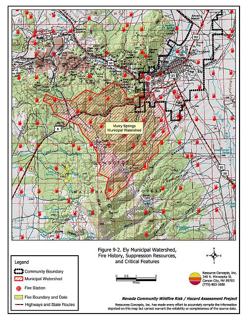
Murry Canyon also presents a significant wildfire hazard. A wind-driven fire in this area could burn quickly through the canyon toward the more populated urban area of Ely. A fire in Murry Canyon would likely result in damage to the watershed that supplies the town’s municipal wells (Buqo 2001).
9.2 Risk and Hazard Reduction Recommendations
The responsibility to keep a community fire safe falls not only on the local fire department but also on residents, businesses, and local governments. Recommendations for homeowners in Ely include implementation and maintenance of defensible space and immediate removal of biomass and any other flammable debris within the defensible space. Recommendations to the town of Ely and White Pine County include fuels reduction in Murry Canyon, the development of shaded fuelbreaks around town, and the reseeding of fuel reduction areas with a pre-suppression, fire resistant seed mix.
9.2.1 Defensible Space Treatments
Defensible space treatments are an essential first line of defense for residential structures. Significantly reducing or removing vegetation within a prescribed distance from structures (30 feet to 200 feet depending upon slope and vegetative fuel type) reduces fire intensity and improves firefighter and homeowner chances for successfully defending a structure against an oncoming wildfire.
Property Owners Recommendations
- Remove, reduce, and replace vegetation around homes according to guidelines provided in Appendix E. This area should be kept:
- Lean: There are only small amounts of flammable vegetation.
- Clean: There is no accumulation of dead vegetation or other flammable debris.
- Green: Existing plants are healthy and green during the fire season.
- Maintain defensible space annually.
- Immediately remove cleared vegetation to an approved disposal site. This material dries quickly and poses a fire risk if left on site. Refer to the Defensible Space fact sheet in Appendix E for clearance guidelines.
- Keep the area beneath unenclosed porches and decks free of accumulated vegetation or other flammable debris. Enclose these areas wherever possible.
- Store woodpiles at least thirty feet from any structure.
- Clear all vegetation and combustible materials around propane tanks for a minimum distance of ten feet.
- Cheatgrass or other annual grasses that have become dominant within the defensible space zone should be mowed or treated with an application of pre-emergent herbicide prior to seed set. Treatments may need to be repeated the following year to ensure that the seed bank of unwanted grasses has been depleted. Refer to Appendix E for approved seed mixes and planting guidelines that can be used in conjunction with removal of this annual grass.
- Remove brush growing within thirty feet and mow grass within ten feet of fences in the community.
- Install spark arrestors on chimneys.
9.2.2 Fuels Reduction Treatments
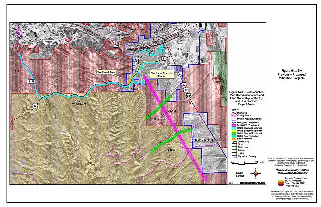
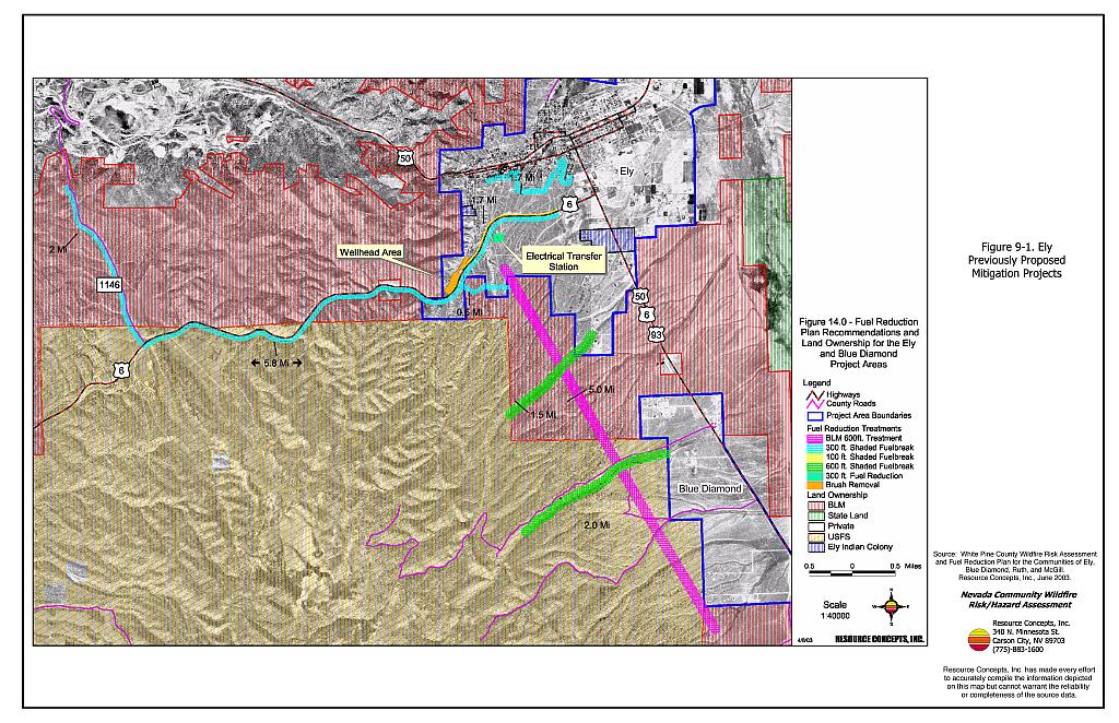
Fuel reduction treatments are applied on a larger scale than defensible space treatments, typically along roads, railroads, vacant lots, power line corridors, or the outer boundaries of a community. Permanently lowering the amount of available fuel over a large block of land reduces the risk of a catastrophic wildfire in the treated area. Fuelbreaks can stop or slow the advance of a wildfire. They also give firefighters a place to stand against an oncoming fire. Refer to Figure 9-1 for the location of previously recommended fuelbreaks and completed fuel reduction treatments in the Ely area.
The Nevada Division of Forestry is planning to implement the treatments described below in April 2005. The remaining recommendations are proposed for the various agencies listed below the Nevada Division of Forestry projects.
Nevada Division of Forestry
- Reduce sagebrush and rabbitbrush density around the wellhead areas in Murry Canyon. The proposed treatment area is approximately twenty acres in size. NDF is planning on treating seven acres in 2005.
- Clear all vegetation within thirty feet of the fence around the electrical transfer station in southwest Ely (two acres).
- Construct a 100-foot wide shaded fuelbreak for a distance of 1.7 miles east of the wellhead protection area and north of Highway 6 according to the proposed location shown on Figure 9-1 (approximately 21 acres).
Bureau of Land Management, US Forest Service, and City of Ely
Shaded fuelbreak and fuelbreak specifications include thinning trees to a spacing of approximately ten trees per acre. Shrubs should be thinned to a canopy spacing of two times the height of the shrubs. Prune branches of remaining trees up to a height of four feet above ground or no more than one-third the height of the tree. Broadcast seed the treated areas prior to tree removal with a seed mix developed for the area such as the one provided in Appendix E.
- Construct a shaded fuelbreak along the south side of Highway 6 by thinning trees and shrubs within a 300-foot wide corridor for a distance of 5.8 miles.
- Construct a 300 foot wide shaded fuelbreak on the south side of Ely from Pole Line Road to Highway 6 for a distance of approximately 0.6 miles.
Bureau of Land Management and US Forest Service
- Construct a 100 to 300 foot wide fuelbreak along the west side of County Road 1146 for a distance of two miles. The fuelbreak should be 300 feet wide in the pinyon-juniper dominated areas and 100 feet wide in the sagebrush dominated areas.
- Maintain the installed fuelbreak along Pole Line road for a distance of 3.5 miles.
- Implement fuel reduction treatments throughout the Ely municipal watershed to reduce the likelihood of a catastrophic fire burning a majority of the watershed area, Protect homes in the Ely wildland-urban interface from fire and reduce the likelihood of a high severity burn which could cause flooding and extreme erosion events that would affect the town (Figure 9-2). The fuel reduction treatment should be implemented where slopes are less than thirty percent. Trees should be thinned to a spacing between canopies of two times the height of the trees. Shrubs should also be thinned to allow a minimum spacing of two times the height of the shrubs. A combination of mowing, thinning, prescribed burning, and seeding can be used to complete the treatments.
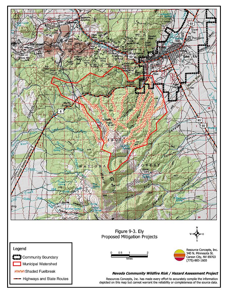
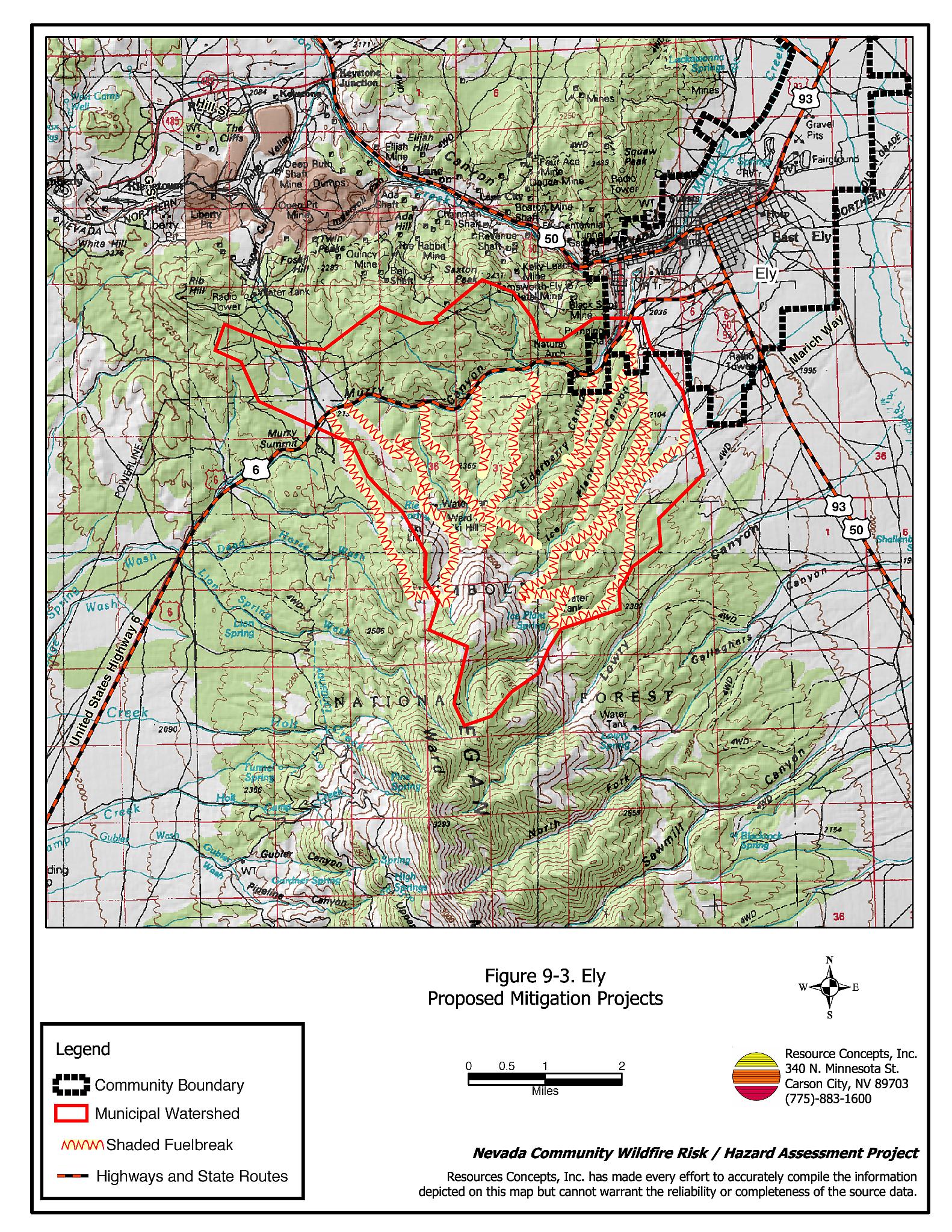
- During the interim period until the watershed treatment can be completed, construct ridgeline and roadside shaded fuelbreaks within the Ely municipal watershed. Due to the large extent and length of time it will take to complete implementation of the proposed fuel reduction treatment area for Ely, construction of shaded fuelbreaks to reduce the continuity of the pinyon, juniper, and sagebrush fuels is a priority. Shaded fuelbreaks should be 300 to 500 feet in width and should be adjusted to the existing variations in topography (Figure 9-3).
- The biomass generated from construction of the fuelbreaks and fuel reduction treatments should be removed and disposed of at an appropriate site (piled and burned or transported off the site). The fuels reduction treatments and fuelbreaks should be managed and retreated as necessary to maintain the desired plant density and spacing.
City of Ely and Property Owners
- Thin trees and shrubs to create a 300-foot wide shaded fuelbreak for a distance of 1.7 miles, behind homes in south Ely from S. Bell Street to Cedar Street.
9.2.3 Community Coordination
Many of the most effective activities aimed at reducing the threat of wildfire for the Town of Ely require that individual property owners coordinate with each other and with local fire authorities. Defensible space, for example, is more effective in small communities when applied uniformly throughout entire neighborhoods. Public education and awareness, neighbors helping neighbors, and proactive individuals setting examples for others to follow are just a few of the approaches that will be necessary to meet the fire safe goals in the community. Disposal of biomass generated from defensible space and fuel reduction treatments can sometimes be most efficiently handled through community programs.
Property Owners
- Assure that address signs are visible from the road. Address characters should be at least four inches high, reflective, and composed of non-flammable material. Improving visibility of addresses will make it easier for those unfamiliar with the area to navigate under smoky conditions that can occur during a wildland fire.
- Form a local chapter of the Nevada Fire Safe Council. The Nevada Fire Safe Council proposes to work on solutions that reduce the risk of loss of lives and property from wildfires in Nevada’s communities. Through establishment of a local Chapter, communities become part of a large, information-sharing network that receives notifications of programs and funding opportunities for fire mitigation projects such as those listed in this report. The Nevada Fire Safe Council will accept and manage grants and contracts on the Chapter’s behalf through its non-profit status. The Nevada Fire Safe Council provides assistance and support to communities to complete fire safe plans, set priorities, educate and train community members, and promote success stories of its members. To form a local Chapter or for more information, contact the Nevada Fire Safe Council, PO Box 2724, Carson City, NV 89702, telephone (775) 884-4455.
City of Ely and White Pine County
- Require all future development in the Ely wildland-urban interface areas to comply with the most stringent fire codes and standards with regards to defensible space, construction materials, road design, and water supply systems. The County must assure that fire safe community recommendations, such as those listed in Appendix F, are adopted in Ely.
Ely Fire Department
- Distribute copies of the publication “Living With Fire” to all property owners who live in Ely. This publication is free of charge. Copies can be requested from the University of Nevada Cooperative Extension.
| Involved Party | Recommended Treatment | Recommendation Description |
|---|---|---|
| Property Owners | Defensible Space Treatments | Remove, reduce, and replace vegetation around homes (see guidelines in Appendix E). Keep defensible space lean, clean, and green. Mow and treat cheatgrass in areas around homes to deplete the seed bank. Reseed with species according to the seed mix in Appendix E. |
| Community Coordination | Assure addresses are visible from the road. Form a local chapter of the Nevada Fire Safe Council with residents of Blue Diamond (Ward Mountain). |
|
| Fuel Reduction Treatments | Construct a 300-foot wide shaded fuelbreak behind homes in south Ely from S. Bell Street to Cedar Street. Construct a 100-foot wide fuelbreak for a distance of 1.7 miles on the north side of Highway 6. |
|
| Bureau of Land Management US Forest Service City of Ely Bureau of Land Management US Forest Service |
Fuel Reduction Treatments Fuel Reduction Treatments |
Construct a shaded fuelbreak along the south side of Highway 6 by thinning trees and shrubs within a 300-foot wide corridor for a distance of 5.8 miles. Construct a 300 foot wide shaded fuelbreak on the south side of Ely from Pole Line Road to Highway 6 for a distance of approximately 0.6 miles. Construct a 100 to 300 foot wide fuelbreak along the west side of County Road 1146 for a distance of two miles. Maintain the installed fuelbreak along Pole Line road for a distance of 3.5 miles. Implement fuel reduction treatments and shaded fuelbreaks in the Ely municipal watershed area to reduce the likelihood of a catastrophic fire that would jeopardize the Ely municipal water supply. |
| City of Ely | Fuel Reduction Treatments | Construct a 300-foot wide shaded fuelbreak behind homes in south Ely from S. Bell Street to Cedar Street. Reduce sagebrush and rabbitbrush density around the wellhead area in Murry Canyon. Construct a 100-foot wide fuelbreak for a distance of 1.7 miles on the north side of Highway 6. |
| City of Ely White Pine County |
Community Coordination | Require all future development in the Ely wildland-urban interface areas to comply with the most stringent fire codes and standards with regards to construction materials, road design, and water supply systems. |
| Nevada Department of Transportation | Fuel Reduction Treatments | Construct a 100-foot wide fuelbreak for a distance of 1.7 miles on the north side of Highway 6. |
| Electrical Utility Company | Fuel Reduction Treatments | Clear all vegetation within thirty feet of the fence around the electrical transfer station in southwest Ely. |
| Ely Fire Department | Community Coordination | Distribute copies of the publication “Living With Fire” to all property owners who live in Ely. |
Figure 9-1Ely Previously Proposed Mitigation Projects |
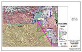 |
Figure 9-2Ely Municipal Watershed, Fire History, Suppression Resources, and Critical Features |
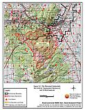 |
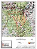
Figure 9-3Ely Proposed Mitigation Projects |
 |