![]()
![]()
10.0 Goshute
10.1 Risk and Hazard Assessment
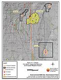
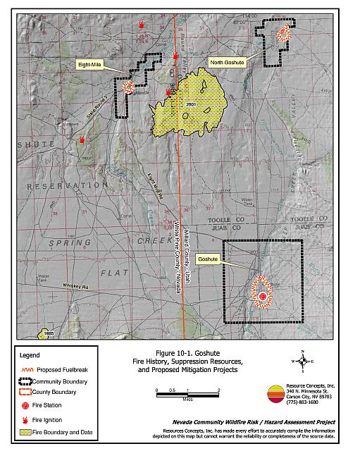
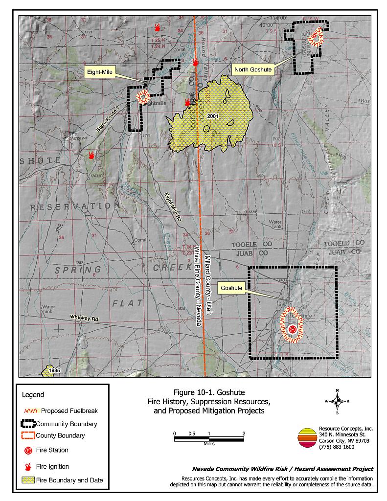
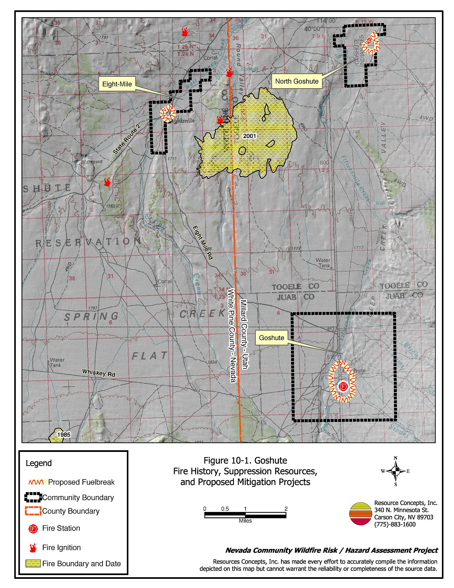
The Goshute Indian Reservation is located in Utah but extends into the northeast portion of White Pine County in Nevada (see Figure 10-1). The reservation includes three residential areas, Goshute, North Goshute, and the Eight-Mile area in Nevada. Fifty-eight homes were observed during the field assessment, of which nine are located within the Eight-Mile area in Nevada.
The hazard assessment resulted in classifying Goshute in the Moderate Hazard Category (58 points). A summary of factors that contributed to the hazard rating is provided in Table 10-3. Primary factors that determined the hazard rating were limited fire suppression resources, inadequate defensible space, little to no address or street signage, and potentially hazardous fire behavior.
10.1.1 Community Design
The wildland-urban interface area around the Eight-Mile portion of the Goshute Reservation can best be characterized as intermixed. Structures are scattered throughout the wildland area with no clear line of demarcation between wildland fuels and the residential structures. The Goshute and North Goshute areas of the Goshute Reservation were considered classic interface. Of the 58 total homes observed on the Goshute Reservation, eleven were on lots of less than one acre, 43 were on parcels between one to ten acres in size, and four were on parcels of more than ten acres. Nine homes in the Eight-Mile neighborhood were included in the assessment.
- Access: The Goshute community can be accessed from a number of small county roads leading from US Alt. 93. Roads within the community are generally flat and of adequate width for fire suppression vehicle maneuverability or two-way vehicle travel.
- Signage: Only 39 of the homes observed in Goshute have address signs, and none of the streets have posted signs. None of the homes in Eight-Mile have visible addresses. Clear and visible street signs and residential addresses are important to aid firefighting personnel in locating at risk areas of a community during low visibility conditions that occur during a wildfire.
- Utilities: Utilities are all above ground. Power lines have not been properly maintained to minimize the possibility that arcing may start fires in nearby vegetation.
10.1.2 Construction Materials
Eighty-eight percent of the homes in the interface are built with non-combustible or ignition resistant siding materials such as medium density fiberboard. All of the homes in Eight-Mile had non-combustible siding. All of the homes also had fire resistant roofing materials such as composition or metal. Only one home observed had an unenclosed balcony, porch, deck, or other architectural feature that could create drafty areas where sparks and embers can be trapped, smolder, ignite, and rapidly spreading fire to the home.
10.1.3 Defensible Space
Slightly more than half of the homes surveyed in Goshute had landscaping that meets the minimum standard as defensible space. Two of the homes in Eight-Mile did not have adequate defensible space.
10.1.4 Suppression Capabilities
Wildfire Protection Resources
Goshute is protected by the Goshute Tribal Volunteer Fire Department, which was reported to be staffed by seven volunteers at the time that interviews were conducted for this report. Additional firefighting resources are available from the BLM Ely Field Office and the Nevada Division of Forestry Ely Conservation Camp as described in Section 4.1.1. Table 10-1 lists the types of wildfire resources and equipment available for initial response to a reported wildfire near Goshute.
| Type of Equipment | Amount of Equipment | Resource Location |
|---|---|---|
| Type 6 Engine | 1 | Goshute Volunteer Fire Department |
| Source: Tribal Representative and Fire Chief Mark Oppenheim | ||
Water Sources and Infrastructure
Water availability for fire suppression in Goshute and North Goshute includes:
- Community wells,
- 500 gpm hydrants within 500 feet of structures,
- Other draft sources such as ranch ponds, and
- Water storage tanks
The water system is operated by gravity and an electric pump. There is no backup emergency generator in the event of a power failure during a wildfire. Additional fire hydrants are located along the road between the Goshute and North Goshute areas. Limited water drafting sources were available for the Eight-Mile area and scattered ranches on the reservation.
Fire Protection Personnel Qualifications
Goshute volunteer firefighters receive training to meet the State of Utah Fire Marshal structure firefighting qualifications, although they do not have any structure firefighting apparatus. Only two of the volunteers have received wildfire training. The Goshute Volunteer Fire Department does not utilize the Red Card system for individual qualifications.
Financial Support
Funding for the Goshute VFD comes from fundraisers.
Community Preparedness
The Goshute Reservation has no community emergency plans.
10.1.5 Factors Affecting Fire Behavior
Vegetation in the Eight-Mile area of the Goshute Reservation was considered a moderate fuel hazard. Fuels in Eight-Mile consist primarily of big sagebrush, rabbitbrush, and greasewood, with an understory of salt grass, basin wildrye, and other perennial grasses. Fuel loads were estimated at three tons per acre.
In the Goshute and North Goshute areas of the Reservation fuel loads were estimated at one to two tons per acre. The fuel hazard in Goshute and North Goshute varied from low to moderate. Predominant vegetation includes big sagebrush, rabbitbrush, basin wildrye, and cheatgrass. The terrain varies from about eight to twenty percent slope with a north aspect. The predominant wind is from the west/southwest in the late afternoon.
10.1.6 Fire Behavior Worst Case Scenario
The worst-case scenario for Goshute would likely be a wind-driven wildfire ignited by lightning in late summer. Winds could come from any direction during thunderstorms, and any part of the community could be threatened. Some structures are protected by agricultural buffer zones, and most of the residences have adequate defensible space, but could still be threatened by a fast moving wildfire. Fire suppression resources are not up to standards for fighting a wildland fire. A wildfire driven by erratic winds could exceed first alarm resources, especially if volunteers were unable to respond immediately. Additional resources are at least one hour away.
10.1.7 Ignition Risk Assessment
Goshute was determined to have a moderate ignition risk based on frequent summer thunderstorms with dry lightning, and fuel loading. There is a moderate risk of structure loss, especially at homes without defensible space. The primary ignition risk in Goshute is lightning, although human caused ignitions can occur at any time.
10.2 Risk and Hazard Reduction Recommendations
The responsibility to keep a community fire safe falls not only on the local fire department but also on residents of the community and the tribal council. Recommendations to reduce hazards and risks in the Goshute community focus on improving defensible space and fuels reduction. Other recommendations pertain to community coordination efforts that could be initiated to enhance fire safety.
10.2.1 Defensible Space Treatments
Defensible space treatments are an essential first line of defense for residential structures. Significantly reducing or removing vegetation within a prescribed distance from structures (30 feet to 200 feet depending upon slope and vegetative fuel type) reduces fire intensity and improves firefighter and homeowner chances for successfully defending a structure against an oncoming wildfire.
Property Owners Recommendations
- Remove, reduce, and replace vegetation around homes according to guidelines provided in Appendix E. This area should be kept:
- Lean: There are only small amounts of flammable vegetation.
- Clean: There is no accumulation of dead vegetation or other flammable debris.
- Green: Existing plants are healthy and green during the fire season.
- Maintain defensible space annually.
- Immediately remove cleared vegetation to an approved disposal site. This material dries quickly and poses a fire risk if left on site. Refer to the Defensible Space fact sheet in Appendix E for clearance guidelines.
- Keep the area beneath unenclosed porches and decks free of accumulated vegetation or other flammable debris. Enclose these areas wherever possible.
- Store woodpiles at least thirty feet from any structure.
- Clear all vegetation and combustible materials around propane tanks for a minimum distance of ten feet.
- Cheatgrass or other annual grasses that have become dominant within the defensible space zone should be mowed or treated with an application of pre-emergent herbicide prior to seed set. Treatments may need to be repeated the following year to ensure that the seed bank of unwanted grasses has been depleted. Refer to Appendix E for approved seed mixes and planting guidelines that can be used in conjunction with removal of this annual grass.
- Remove brush growing within thirty feet and mow grass within ten feet of fences in the community.
- Install spark arrestors on chimneys.
10.2.2 Fuel Reduction Treatments
Fuel reduction treatments are applied on a larger scale than defensible space treatments. By permanently changing the fuel structure over large blocks of land to one of lower volume or reduced flammability (a fuel reduction treatment), the expected result in the event of a catastrophic wildfire would be one of reduced risk for uncontrolled spread through the treatment area. Reducing vegetation along roadways and driveways could reduce the likelihood of wildfire spreading across roads and improve firefighter access and safety for protecting homes.
Electric Utility Company
Power line corridors and transformer sites should be kept clear of flammable vegetation, as fires have been known to start from arcing power lines during windy conditions. Fire damage to power lines often creates power failures that can be especially dangerous in communities without a backup energy source. Energized power lines can also fall during a wildfire creating additional hazards for citizens and firefighters.
- Maintain utility right-of-ways by removing trees from beneath power lines and thinning shrubs a minimum of fifteen feet around power line transformers.
Goshute Tribal Council
- Coordinate with the Bureau of Indian Affairs to establish fuel reduction treatments as detailed on Figure 10-1 of this report. Three 300-foot wide fuelbreaks are recommended, one around the Tribal Headquarters (Goshute), one south of North Goshute, and one around homes in Eight-Mile. National Fire Plan funding may be available through the Bureau of Indian Affairs for fuel reduction treatment implementation.
- Reduce vegetation by mowing it to a height of not more than four inches for a distance of 25 feet from the edge of the pavement, along both sides of county roads. Seed or treat the cleared areas as necessary to control cheatgrass.
10.2.3 Fire Suppression Resources
Adequate training, equipment, and water drafting supplies are critical to firefighters, be they first responders, volunteer fire department personnel, or agency personnel. These matters are of special importance to all communities, especially those located in remote portions of the county. The following recommendations are related to actions the Goshute Tribe can take to increase the quality of fire suppression response in their community.
Goshute Tribal Council and Goshute Tribal Volunteer Fire Department
- Coordinate with the Bureau of Indian Affairs, Tribal Headquarters, and the Bureau of Land Management to obtain funding for engines, water tenders, protective equipment, a fire station/storage facility, and wildland firefighter training. The Bureau of Indian Affairs has access to National Fire Plan funding for grants to enhance wildfire safety on tribal lands.
- Coordinate with the Bureau of Indian Affairs to secure funding to upgrade existing equipment and to add on to the existing fire station.
- Meet annually with Tribal Headquarters, the Bureau of Indian Affairs, and the Bureau of Land Management fire management personnel to review pre-attack plans and to coordinate firefighting resources and response procedures.
10.2.4 Community Coordination
Many of the most effective activities aimed at reducing the threat of wildfire for the Goshute Indian Reservation require that individual property owners coordinate with each other and with their local fire department. Defensible space, for example, is more effective in small communities when applied uniformly throughout entire neighborhoods. Public education and awareness, neighbors helping neighbors, and proactive individuals setting examples for others to follow are just a few of the approaches that will be necessary to meet the fire safe goals in the community.
Property Owners
- Assure that address signs are visible from the road. Address characters should be at least four inches high, reflective, and composed of non-flammable material. Improving visibility of addresses will make it easier for those unfamiliar with the area to navigate under smoky conditions during a wildland fire.
- Form a local chapter of the Nevada Fire Safe Council. The Nevada Fire Safe Council proposes to work on solutions that reduce the risk of loss of lives and property from wildfires in Nevada’s communities. Through establishment of a local Chapter, communities become part of a large, information-sharing network that receives notifications of programs and funding opportunities for fire mitigation projects such as those listed in this report. The Nevada Fire Safe Council will accept and manage grants and contracts on the Chapter’s behalf through its non-profit status. The Nevada Fire Safe Council provides assistance and support to communities to complete fire safe plans, set priorities, educate and train community members, and promote success stories of its members. To form a local Chapter or for more information, contact the Nevada Fire Safe Council, PO Box 2724, Carson City, NV 89702, telephone (775) 884-4455.
Goshute Tribal Volunteer Fire Department
- Distribute copies of the publication “Living With Fire” to all property owners who live in Goshute. This publication is free of charge, and copies can be requested from the University of Nevada Cooperative Extension.
| Involved Party | Recommended Treatment | Recommendation Description |
|---|---|---|
| Property Owners | Defensible Space Treatments | Remove, reduce, and replace vegetation around homes according to the guidelines in Appendix E. Maintain defensible space as needed to keep the space lean, clean, and green. |
| Community Coordination | Post addresses so they are clearly visible. Form a local chapter of the Nevada Fire Safe Council. |
|
| Utility Company | Fuel Reduction Treatments | Remove trees and thin shrubs beneath power lines and utility poles. Maintain a minimum of fifteen feet of clearance around power line transformers. |
| Goshute Tribal Volunteer Fire Department | Fire Suppression Resources | Coordinate with BIA and BLM to obtain funding for additional and upgraded wildfire suppression equipment and wildland fire training. |
| Community Coordination | Distribute copies of the publication “Living With Fire” to all property owners. | |
| Goshute Tribal Council | Fuels Reduction Treatments | Construct three 300-foot wide fuelbreaks are recommended, one around the Tribal Headquarters (Goshute), one south of North Goshute, and one around homes in Eight-Mile. |
| Mow vegetation along roads for a minimum width of 25 feet from both sides of the roads |
Table 10-3Goshute Wildfire Hazard Rating Summary |
 |
Figure 10-1Goshute Fire History, Suppression Resources, and Proposed Mitigation Projects |
 |