![]()
![]()
5.0 Cave Rock/Skyland
5.1 Risk And Hazard Assessment
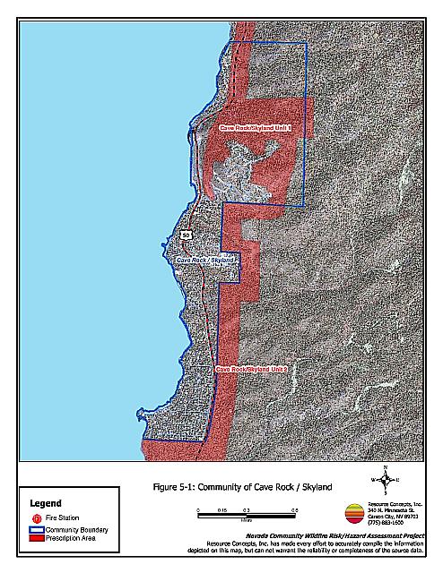
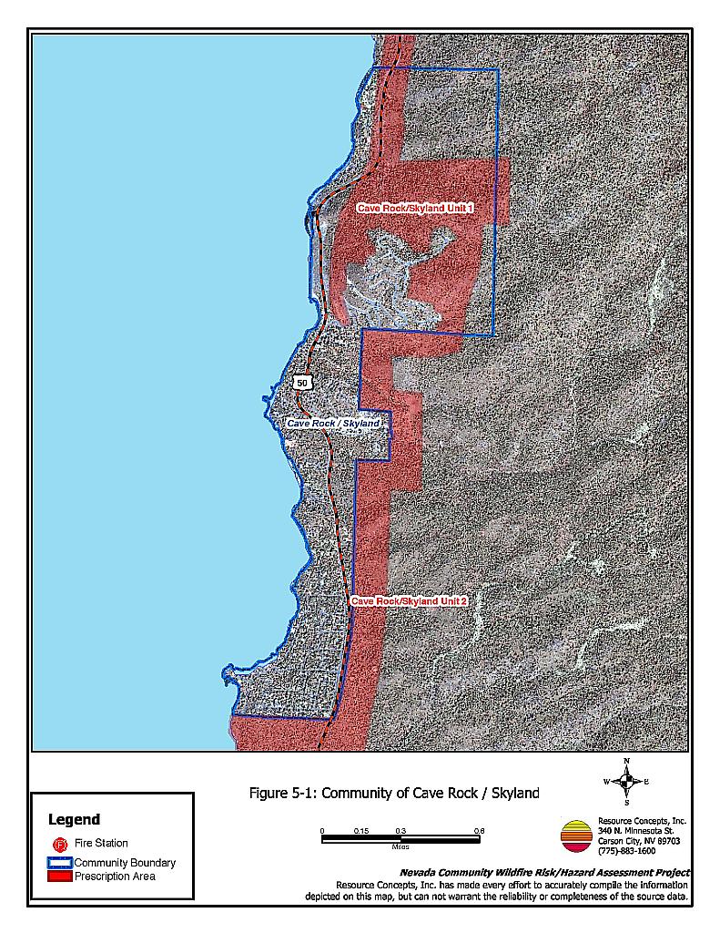
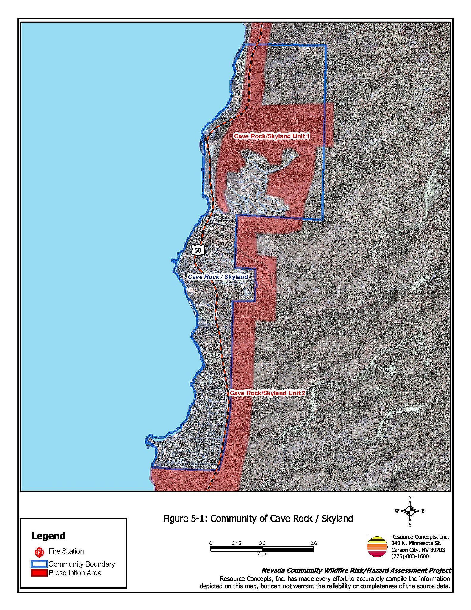
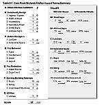
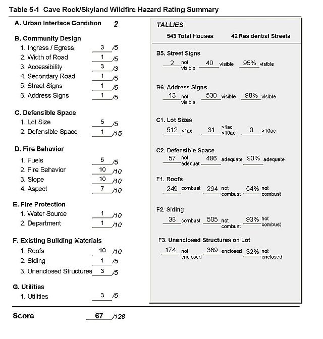
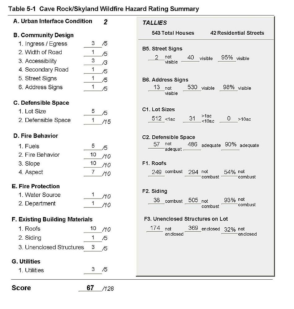
Cave Rock and Skyland are located along US Highway 50 on the east shore of Lake Tahoe (See Figure 5-1). The communities are characterized by steep slopes with a south and west aspect. The dominant vegetation is a Jeffery pine tree layer with some associated white fir and incense cedar. The west slopes above the community have a dense understory of mountain mahogany. The risk assessment resulted in classifying Cave Rock/Skyland in the High Hazard category (67 points). The rating is attributed primarily to a high number of wood shake roofs and unenclosed decks or porches, and fire behavior factors. The Cave Rock/Skyland Risk/Hazard Assessment Summary is provided as Table 5-2.
5.1.1 Community Design
The urban interface condition surrounding Cave Rock and Skyland is classified as an intermix condition. Structures are scattered throughout the wildland area. There is no clear line of demarcation between structures and wildland fuels along roads or back fences. There were 543 single-family residences observed in the assessment area. The majority of homes are on lots of one acre or less - only 31 homes in the communities are on lots of between one and ten acres/
- Roads: US Highway 50 is the major transportation route through Cave Rock and Skyland. This primary access is at least 24 feet wide, paved and has adequate turnaround space for fire suppression equipment. The majority of the secondary roads have adequate width but have slightly less than a 45-degree turning radius, which could make it difficult for some fire suppression equipment to turn around. The secondary roads are primarily steep and winding.
- Signage: Street signs are present and visible on 96 percent of the streets; however many of the street signs are wood post signs. This type of signage is not recommended because it is flammable and could make it difficult for fire fighters to find a specific street in the event of a wildfire. Residential addresses are visible on 98 percent of the homes, which will assist firefighters in locating specific homes during poor visibility conditions that may occur during a wildland fire.
5.1.2 Construction Materials
Ninety-three percent of the homes observed during the risk assessment are built with non-combustible siding material. Only 54 percent of the homes have non-combustible roofs made of tile, metal or composition. Thirty-two percent of the homes observed have unenclosed balconies, porches, decks or other architectural features that can create drafty areas where sparks and embers can smolder and spread fire to the home.
5.1.3 Defensible Space
About 90 percent of the homes have the minimum recommended defensible space to help protect the home from damage or loss during a wildfire. Tahoe-Douglas FPD regulations require 30 to 100 feet of defensible space, depending on the slope of the terrain surrounding the home. Steeper slopes require more defensible space on the downhill side of lots, because flame lengths are longer on slopes. See Appendix D for defensible space guidelines.
5.1.4 Factors Affecting Fire Behavior
The Cave Rock and Skyland communities are situated on terrain that ranges from moderate slopes on the west side of Highway 50, to nearly 70 percent slopes to the east of the highway. Many homes are directly within dense stands of vegetation, and in saddles that, in concert with strong winds, could create a chimney effect during a wildfire, drawing fire into a community. The dominant vegetation layer is a tree overstory of Jeffrey pine, with white fir and some incense cedar. The tree canopy is closed. The shrub layer includes manzanita, snowbrush, bitterbrush, and rabbitbrush. Ground fuels consist of pine needles and cones, grasses, and annuals including cheatgrass. Fuels are heavy, estimated at six to eight tons per acre. The composition of the fuels is conducive to crown fires or high intensity surface fires. The tree density is considered heavily overstocked. In addition, many of the trees in this area are infested with dwarf mistletoe. This invasive parasite weakens the tree, and will eventually kill infected trees, contributing to standing dead or dead and down fuels. The aspects are to the south and west. The area may experience strong downslope winds during thunderstorms. There are continuous fuels in close proximity to structures. The steep slopes, southern aspects, dense fuels, heavy duff, prevailing wind exposure and ladder fuels may reduce fire suppression effectiveness.
5.1.5 Fire Behavior Worst Case Scenario
The worst-case scenario for Cave Rock and Skyland would be an ignition that begins south of the community in the afternoon of a summer day. Strong predominant west winds would drive the fire up steep slopes into homes. Flame lengths increase with steeper slopes. The dense ground and shrub layer would provide “ladder fuels” that would eventually feed the fire into the tree crown. The communities have one road into and out of the community. This limited access would create problems with evacuation and fire-fighter access, and visibility could be reduced because of heavy smoke. The secondary roads often do not offer adequate turn-around space or width for two-vehicle passage.
A structure fire could also be the source of ignition that spreads wildfire to adjacent homes and into the forest. Factors described for the first worst-case scenario would be the same.
5.1.6 Risk Assessment
Cave Rock and Skyland have a high potential for ignition, and a high risk of structure loss during a fire. Ignition risks fall into two categories - lightning and human caused. Human caused ignitions can come from a variety of sources: fires started along highways and county roads from burning material thrown out of vehicle windows or ignited during auto accidents; off-road vehicles; powerlines; debris burning in piles or burn barrels; unextinguished matches, and fireworks are a few examples. Homes in Cave Rock and Skyland are positioned directly in dense tree and shrub stands, and many have wood shake roofs or unenclosed decks and porches. These kinds of construction make the home even more vulnerable to ignition because flying embers or sparks can lodge and smolder in shake roofs, or under porches in vegetation, eventually spreading fire to the home. Homes spaced close together pose a risk to one another as well, because the radiant heat from one burning structure can ignite homes close-by.
5.2 Risk and Hazard Reduction Recommendations, Roles And Responsibilities
The responsibility to keep a community fire safe falls not only on the local fire department but also on the residents of the community, businesses, and local governments. General recommendations related to defensible space, fuel reduction, community preparedness, and public education, are included in Chapter 4.0. Two fuel reduction projects totaling approximately 450 acres that include treatment for dwarf mistletoe are detailed in the project worksheets in Chapter 11.
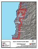
Figure 5-1Communities of Cave Rock/Skyland |
 |
Table 5-1Cave Rock/Skyland Wildfire Hazard Assessment Rating Sheet |
 |