![]()
![]()
6.0 Elk Point/Zephyr Heights/Round Hill
6.1 Risk And Hazard Assessment
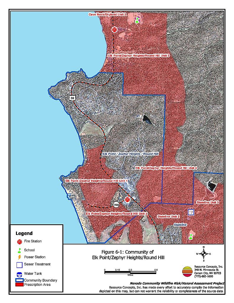
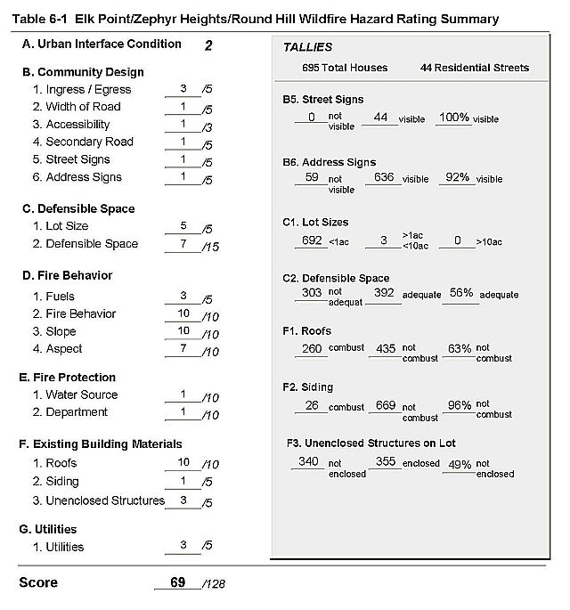
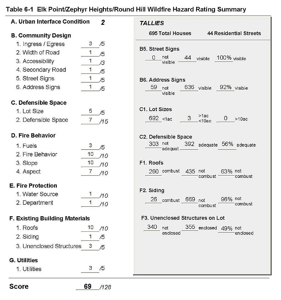
The Elk Point community is located east of US Highway 50, on the east shore of Lake Tahoe; Round Hill is west of Highway 50, and Zephyr Heights is north of Elk Point, east of the highway. Figure 8-1 details the location of the three communities. Elk Point is situated primarily on flat terrain with a gently sloping west aspect; Round Hill and Zephyr Heights are on steep slopes greater than 30 percent. The dominant vegetation type is a Jeffery pine tree layer with some white fir, incense cedar, and sugar pine. The risk assessment resulted in classifying Elk Point, Round Hill and Zephyr Heights in the High Hazard category (69 points). The rating is attributed primarily to inadequate defensible space, close residential structure spacing, a high number of combustible roofs and unenclosed architectural features, some inadequate address signage, and fire behavior factors. The Elk Point/Zephyr Heights/Round Hill Community Hazard Assessment Summary is included as Table 6-1.
6.1.1 Community Design
The urban interface surrounding Elk Point/Zephyr Heights/Round Hill is considered an intermix condition. Structures are scattered throughout wildland fuels with no clear line of demarcation between residential areas and vegetation, or along roads. There were 695 homes observed in the interface during the assessment. Most of the homes are on lots of one acre or less.
- Roads: US Highway 50 is the primary access road through the communities. Most of the residential streets have a grade greater than 5%, but are wide enough for two-vehicle passage or fire suppression equipment turn-around.
- Signage: All of the street signs in the area are clearly posted and visible. This helps fire suppression personnel to locate at-risk neighborhoods during a wildfire. Ninety-two percent of the homes had clear and visible address signage. Address visibility will assist fire fighters to locate specific at-risk homes during a wildfire.
6.1.2 Construction Materials
Ninety-six percent of the homes observed have non-combustible siding. Approximately two-thirds of the homes have non-combustible roofing such as tile, metal, or composition. The rest are wood shake. Nearly half of the homes, 49 percent, have unenclosed porches, decks or balconies. Wood shake roofs and unenclosed architectural features provide areas where flying embers or sparks can lodge and smolder, eventually spreading fire to the home.
6.1.3 Defensible Space
Just over half of the homes (56%) observed have adequate defensible space. Tahoe-Douglas FPD regulations require 30 to 100 feet of defensible space, depending on the slope of the terrain surrounding the home. Steeper slopes require more defensible space on the downhill side of lots, because flame lengths are longer on slopes. See Appendix D for the Tahoe Basin Fire Protection Districts Defensible Space and Thinning Guidelines.
6.1.4 Factors Affecting Fire Behavior
The vegetation in these communities is dominated by a tree layer of Jeffery pine and white fir, with some smaller incense cedar and sugar pine. The understory shrub layer is composed of manzanita, snowbrush, bitterbrush, and rabbitbrush. Ground fuels are composed of a heavy duff layer with pine needles and cones, dead and down woody fuels, and annuals including cheatgrass. Trees in Elk Point are infested with dwarf mistletoe. This invasive parasite weakens the tree and will eventually kill it, leading to more standing dead or dead and down fuel. Fuel loading overall is estimated at six to eight tons per acre. Topographical factors include steep slopes, which leads to increased flame length and rate of spread; saddles and canyons that can create a chimney affect when paired with strong winds.
6.1.5 Fire Behavior Worst Case Scenario
The worst-case scenario fire for Elk’s Point and Zephyr Heights would be a lightning strike uphill and east of the communities. Erratic winds during a thunderstorm would drive the fire into the communities and homes in overstocked tree stands. Dense understory shrubs and ground fuels would fuel the fire, and eventually ladder the fire into the tree crown. The closed canopy will hold the heat in, increasing radiant heat and ignition of other homes. In addition, radiant heat from one home could ignite others because of the close spacing of structures. In Round Hill, the primary risk is a structure fire that vents into the tree crown, again causing a crown fire with heat held in by the closed canopy and radiant heat that could ignite homes close by. The communities have only one way into and out of the area, which could cause problems for suppression equipment access and resident evacuation.
6.1.6 Risk Assessment
The three communities have a high potential for a fire ignition and structure loss. Close home spacing, combustible roofs and unenclosed architectural features, about half of the homes without adequate defensible space, and a closed tree canopy, all contribute to the high risk of property loss or damage, and the risk of loss of life as well.
6.2 Risk and Hazard Reduction Recommendations, Roles And Responsibilities
The responsibility to keep a community fire safe falls not only on the local fire department but also on the residents of the community, businesses, and local governments. General recommendations related to defensible space, fuel reduction, community preparedness, and public education, are included in Chapter 4.0. Four fuelbreak and fuel reduction projects totaling over 1,000 acres are recommended for the Elk Point, Round Hill and Zephyr Heights communities. Project specifications including treatment for dwarf mistletoe are detailed in the project worksheets in Chapter 11.
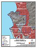
Figure 6-1Communities of Elk Point/Zephyr Heights/Round Hill |
 |
Table 6-1Elk Point/Zephyr Heights/Round Hill Wildfire Hazard Assessment Rating Sheet |
 |