![]()
![]()
9.0 Logan Shoals
9.1 Risk And Hazard Assessment
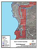
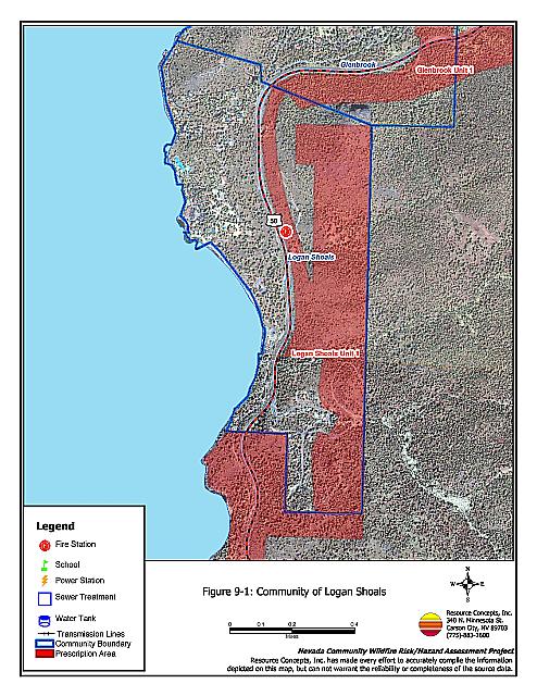
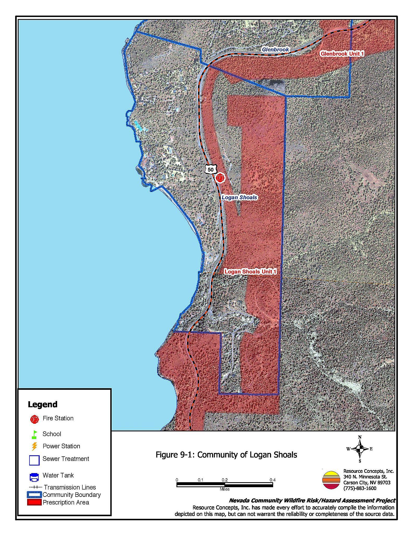
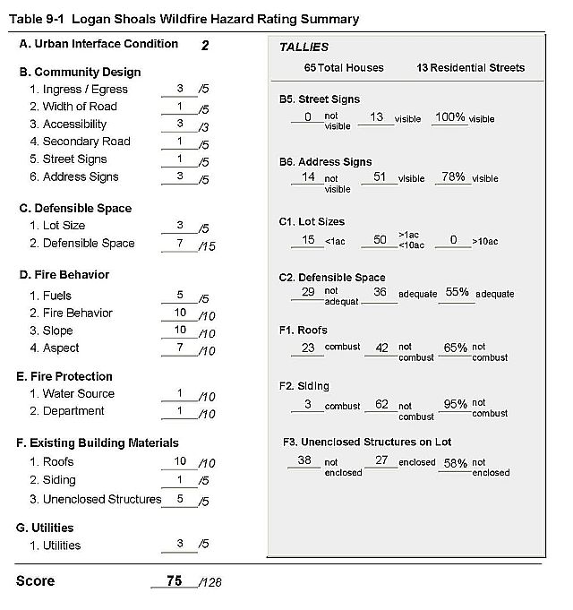
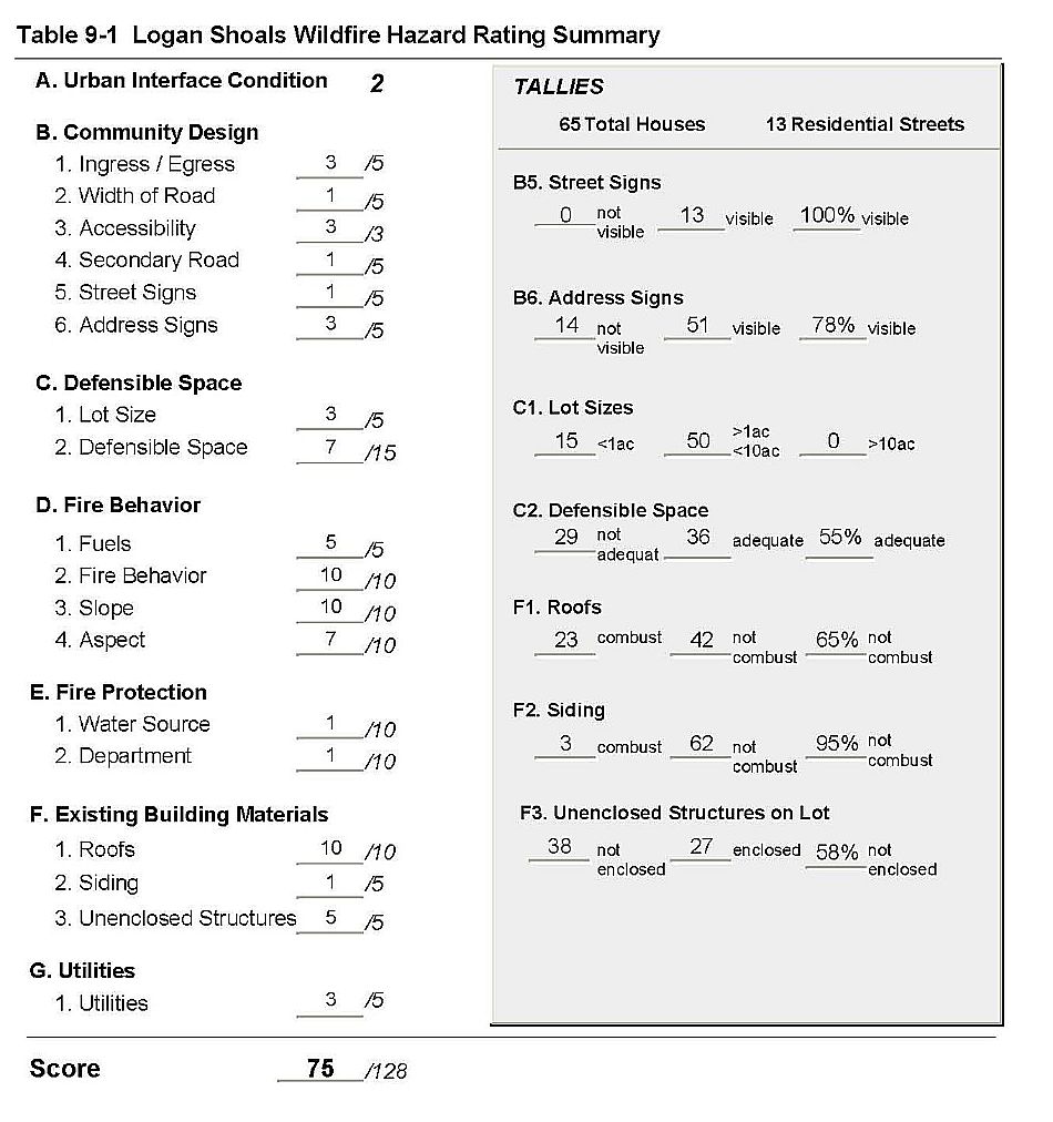
Logan Shoals is located along US Highway 50, on the east side of Lake Tahoe and south of Glenbrook. (Figure 9-1). Logan House Creek runs through the south portion of the community. Slopes in the area vary from about 15 percent on the west side of the highway near the lake, to over 65 percent above the highway. The aspect is generally to the west. Vegetation is primarily a Jeffery pine tree layer with a manzanita understory shrub component and thick ground fuels. The risk assessment resulted in classifying Logan Shoals in the High Hazard category. (75 points). The primary factors that contribute to the high score are combustible roofs and unenclosed architectural features, inadequate defensible space, poorly visible address signage, and fire behavior factors. The Logan Shoals Hazard Assessment Summary is included as Table 9-1.
9.1.1 Community Design
The interface condition surrounding Logan Shoals is intermix. Homes are scattered throughout the forest vegetation with no clear line of demarcation of the community boundary. Sixty-five homes were observed during the assessment. The majority of houses are on lots of between one and ten acres; 15 of the homes are on one acre or less.
- Roads: US Highway 50 is the primary road through Logan Shoals. Residential secondary roads are generally of adequate width for two-vehicle passage; however there is typically not enough turn-around space for fire suppression equipment to maneuver, and some of the roads are steep and winding. This could lead to problems with access and evacuation during a wildfire event.
- Signage: The residential street signs are all clearly posted and easily visible. However, residential addresses were only clearly visible on 78 percent of the homes observed in the assessment. Clear and visible address and street signs assist fire protection personnel in locating at-risk neighborhoods and homes during emergencies, including fires.
9.1.2 Construction Materials
The majority of homes observed (95%) have fire-resistant siding. Approximately two-thirds (65 percent) of homes have non-combustible roofing material such as metal, tile, or composition. The rest are wood shake. Over half of the homes (58%) have unenclosed porches, decks, or balconies. Such architectural features and wood shake roofs provide spaces where flying embers or sparks can lodge and smolder, eventually spreading fire to the home.
9.1.3 Defensible Space
Just over half of the homes observed (55%) have adequate defensible space to protect the home during a wildfire. Tahoe-Douglas FPD regulations require 30 to 100 feet of defensible space, depending on the slope of the terrain surrounding the home. Steeper slopes require more defensible space on the downhill side of lots, because flame lengths are longer on slopes. See Appendix D for the Tahoe Basin Fire Protection Districts Defensible Space and Thinning Guidelines.
9.1.4 Factors Affecting Fire Behavior
Logan Shoals is situated on both sides of US Highway 50, on flat to gently sloping terrain west of the highway, and on steep slopes to the east. The vegetation is dominated by a layer of Jeffrey pine with some white fir, incense cedar, and sugar pine. Stream zones have willows, aspen, and mountain alder. The tree canopy is closed. The understory shrub component is manzanita, snowbrush, and bitterbrush. Ground fuels are composed of a thick duff of pine needles and cones, dead and down woody fuels, and annuals including cheatgrass, which is found primarily along roadsides and in disturbed areas. Fuel loading overall is heavy, estimated at six to eight tons per acre. Winds are primarily from the west and southwest. The composition of the fuels is conducive to crown fires. The fuel density, understory ladder fuels, and slope together may limit opportunities for effective initial attack.
9.1.5 Fire Behavior Worst Case Scenario
Topographic factors, fuel load, residential structure factors, and access all contribute to the worst-case scenario for Logan Shoals. A fire ignition in the Logan Creek area east of Highway 50 and below the residential area would be driven by the predominant west to southwest winds into the residential area. Heavy ground and understory fuels would ladder the fire into the tree crown. As the fire moved further into the community, increasing slopes would contribute to higher flame lengths. Homes situated directly in dense tree stands are at risk of embers and flames from ignited trees that overhang wood shake roofs and unenclosed architectural features. The closed tree canopy will hold heat in, increasing the radiant heat from the fire. Radiant heat alone can ignite fuels and homes, and radiant heat from one home on fire can easily ignite homes close by.
The same results could be seen from an ignition that started from a structure fire.
9.1.6 Risk Assessment
Logan Shoals has a high potential for ignition, as well as a high potential for structure loss during a wildfire. In the Logan Shoals area, primary ignition risks are lightning, auto accidents on the highway, and the possibility of a fire starting from unextinguished cigarettes thrown out of car windows. Topographic, construction, and fuel loading factors increase the risk of structure loss, as described in the Worst Case Fire Behavior Scenario above.
9.2 Risk and Hazard Reduction Recommendations, Roles And Responsibilities
General recommendations related to defensible space, fuel reduction, community preparedness, and public education, are included in Chapter 4. One fuel reduction treatment project was recommended for Logan Shoals of approximately 250 acres. A detailed project description is specified on the project worksheet in Chapter 11.
Figure 9-1Community of Logan Shoals |
 |
Table 9-1Logan Shoals Wildfire Hazard Assessment Rating Sheet |
 |