![]()
![]()
8.0 Kingsbury
8.1 Risk And Hazard Assessment
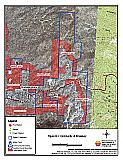
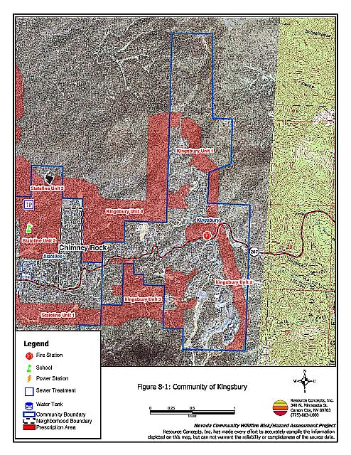
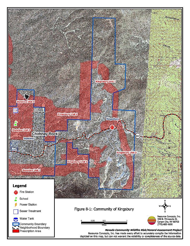
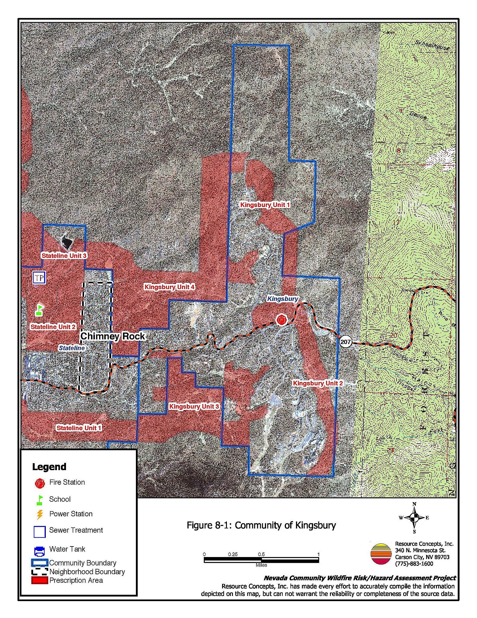
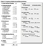
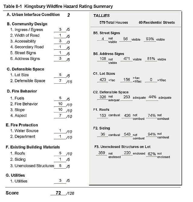
Kingsbury is located on Kingsbury Grade (State Route 207) (See Figure 8-1). The community is situated on steep slopes above and to the east of Lake Tahoe. The topography is characterized by narrow canyons, saddles, and ridgetops, all of which contribute to worst-case fire behavior. Together with strong winds, the canyons can act as a chimney, drawing a wildfire into the community. The risk assessment resulted in classifying Kingsbury in the High Hazard category (72 points). The rating is attributed to fire behavior factors, inadequate defensible space, combustible construction materials, and homes spaced close together. The Kingsbury Hazard Assessment Summary is included as Table 8-1.
8.1.1 Community Design
Kingsbury is classified as an intermix interface type. Structures are scattered throughout wildland fuels with no clear line of demarcation between the residential area and the forest. There were 579 homes observed in the assessment area. Most of the homes are situated on lots of one acre or less; 156 are on lots of between one and ten acres.
- Roads: Kingsbury Grade (SR 207) is the primary transportation route through the Kingsbury community. The secondary roads are steep, generally with a grade of more than five percent. Many of them are winding and narrow as well, and dead-end without sufficient turn around space for vehicles to maneuver. Access here is a risk factor in that the narrow, steep roads may not be adequate for quick response by fire suppression equipment in the event of a wildfire. In addition, two vehicle passage may not be possible in reduced visibility conditions present during a fire.
- Signage: Street signs were clearly posted and visible on 83 percent of the roads. Addresses were visible on approximately 80 percent of the homes observed. Clear and visible address signage is important for firefighters to be able to locate at-risk neighborhoods and homes during wildfires.
8.1.2 Construction Materials
Nearly all (94 percent) of the homes in the area have non-combustible siding; somewhat less (74 percent) have non-combustible roofs of tile, metal, or composition. The rest are wood shake shingles. Sixty-two percent of the homes observed have unenclosed decks, porches, or balconies. Wood shake roofs and unenclosed architectural features provide areas where flying embers or sparks can lodge and smolder, eventually spreading fire to the home. Vegetation or debris under decks or on roofs provides a fuel source for any ignition.
8.1.3 Defensible Space
Less than half of the homes (44%) have adequate defensible space to protect the home in the event of a wildfire. Tahoe-Douglas FPD regulations require 30 to 100 feet of defensible space, depending on the slope of the terrain surrounding the home. Steeper slopes require more defensible space on the downhill side of lots, because flame lengths are longer on slopes. See Appendix D for the Tahoe Basin Fire Protection Districts Defensible Space and Thinning Guidelines.
8.1.4 Factors Affecting Fire Behavior
Topography in Kingsbury is characterized by steep slopes, canyons, saddles, and ridgelines. In concert with strong winds, these topographical features can create a chimney effect, drawing fire up slopes and through canyons, and thus through the community. The topography may inhibit initial attack resources. Vegetation is primarily a tree layer of Jeffery pine and white fir with some incense cedar and sugar pine. The understory shrub layer is composed of manzanita, snowbrush, bitterbrush, whitethorn, and chinquapin. Ground fuels consist of a thick layer of pine needles and cones, dead and down woody fuels, and annuals. The overall fuel loading is heavy, estimated at six to eight tons per acre.
8.1.5 Fire Behavior Worst Case Scenario
The worst-case scenario for the Kingsbury community would be a fire beginning below the Kingsbury area, driven by west to southwest winds and fueled by dense understory shrubs and ground fuels. Steep slopes and other topographical factors would lead to a fast rate of spread and long flame lengths. The heavy understory would ladder the fire into the closed tree canopy, creating a crown fire. The closed canopy would trap heat, increasing radiant heat to temperatures hot enough to ignite homes. The radiant heat from one home on fire would be enough to ignite other homes close by. Combustible construction materials and unenclosed architectural features pose a high risk of ignition to homes in this worst-case scenario. A structure fire that spreads into the tree crown is an alternate beginning to this scenario.
8.1.6 Risk Assessment
Kingsbury has a high potential both for ignition and for structure loss once a fire begins. Topograhic factors may reduce initial attack efforts. Access issues will make it difficult for fire suppression equipment to maneuver while residents are evacuating the area. Combustible construction materials and inadequate defensible space contribute significantly to the risks of property loss, and possible loss of life as well.
8.2 Risk and Hazard Reduction Recommendations, Roles And Responsibilities
The responsibility to keep a community fire safe falls not only on the local fire department but also on the residents of the community, businesses, and local governments. General recommendations related to defensible space, fuel reduction, community preparedness, and public education, are included in Chapter 4.0. Brush removal and thinning treatments for fuel reduction were recommended as four separate projects totally more than 1,100 acres around the Kingsbury community. Three of the four projects recommended are top priorities for the Tahoe-Douglas Fire Protection District. Project specifications are detailed on the project worksheets in Chapter 11.
Figure 8-1Community of Kingsbury |
 |
Table 8-1Kingsbury Wildfire Hazard Assessment Rating Sheet |
 |