![]()
![]()
10.0 Stateline
10.1 Stateline Risk And Hazard Assessment
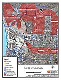
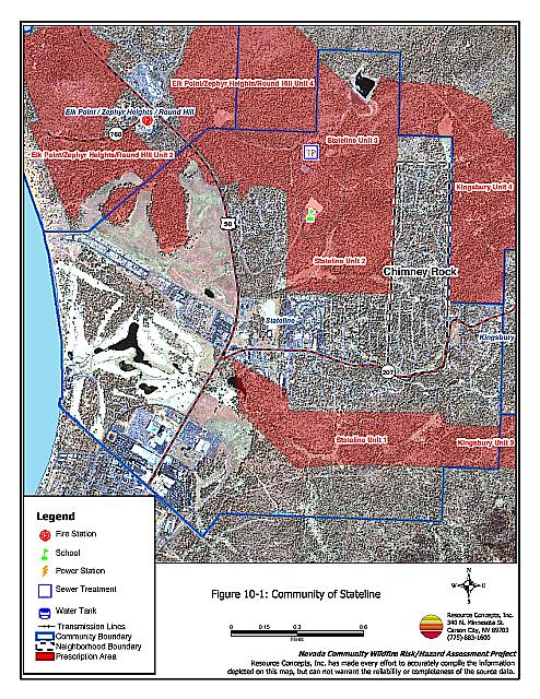
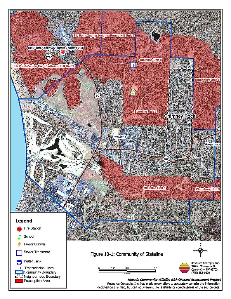
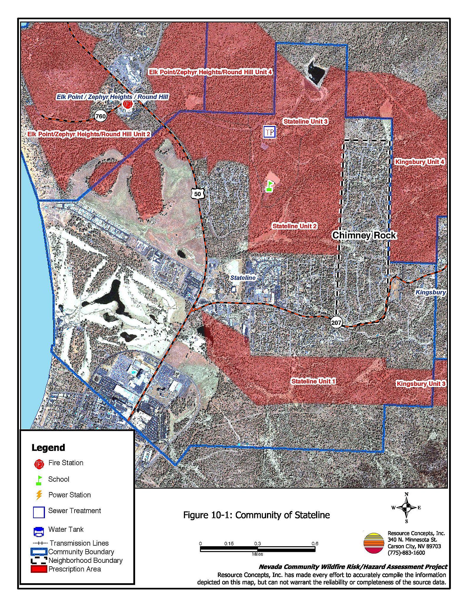
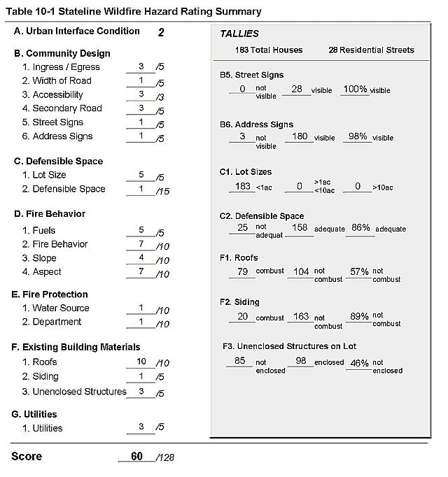
Stateline is located along US Highway 50. (See Figure 10-1). Kingsbury Grade (State Route 207) bisects the community. The terrain in Stateline is relatively flat, with slightly higher gradients to the east. Slopes range between 8 and 20 percent. Vegetation consists of a Jeffrey pine and white fir tree layer, with an understory of shrubs and thick ground fuels. The community is surrounded by large tracts of US Forest Service land, and the Park Cattle Company land to the south. Several casinos are located south of the community. The Risk/Hazard Assessment resulted in classifying Stateline in the Moderate Hazard category (60 points). The relatively low assessment score is primarily due to good defensible space and moderate slopes. The Stateline Hazard Assessment Summary is included as Table 10-1.
Within the Stateline Community, the Chimney Rock neighborhood was assessed separately. This neighborhood was separated out because of varying topography, access, residential structure composition, and other factors that affect the hazard rating. A description of Chimney Rock follows after the other portions of Stateline are described.
10.1.1 Community Design
The interface surrounding Stateline is generally an intermix condition. In the northern part of the community, structures are scattered throughout wildland fuels, with no clear community boundary. The southern part of Stateline is primarily a classic interface, with streets providing a demarcation between residential structures and wildland fuels. There were 183 homes observed during the assessment. All of the homes are on lots of one acre or less in size.
- Roads: Kingsbury Grade is the primary road through Stateline. In the area north of Kingsbury Grade, the secondary residential roads are primarily steep and winding, with a grade of more than 5 percent and dead-ends that do not provide adequate turn-around space for vehicles, especially fire suppression equipment. This could reduce suppression response. In the are south of Kingsbury Grade the secondary roads have a grade less than 5 percent, are relatively straight, and have adequate turn-around space for vehicles.
- Signage: Street signs are clearly posted and visible on all of the residential roads. Addresses are clearly visible on 98 percent of the homes.
10.1.2 Construction Materials
The majority of homes (89 nine percent) are built with fire-resistant siding. However, only 57 percent of the homes have non-combustible roofs made of metal, tile, or composition. Forty-six percent of homes have unenclosed decks, porches, or balconies. Wood shake roofs and unenclosed architectural features provide areas where sparks and embers can lodge and smolder, eventually spreading fire to the home.
10.1.3 Defensible Space
Eighty-six percent of homes in Stateline have adequate defensible space to protect the home during a wildfire. Tahoe-Douglas FPD regulations require 30 to 100 feet of defensible space, depending on the slope of the terrain surrounding the home. Steeper slopes require more defensible space on the downhill side of lots, because flame lengths are longer on slopes. See Appendix D for the Tahoe Basin Fire Protection Districts Defensible Space and Thinning Guidelines.
10.1.4 Factors Affecting Fire Behavior
Topography in Stateline is generally flat to gently sloping, with the steepest slopes up to 20 percent on the east side near the Chimney Rock neighborhood. Vegetation consists of a Jeffrey pine/white fir tree layer with some willow, aspen, and mountain alder in the stream zones. The understory shrub component is composed of manzanita, snowbrush, whitethorn, rabbitbrush, and some sagebrush along roads and disturbed areas. Ground fuels are a thick layer of pine needles and cones, dead and down woody fuels, squaw carpet, and annuals including cheatgrass. Fuel loading is heavy, estimated at 6 tons per acre.
10.1.5 Fire Behavior Worst Case Scenario
Fire behavior factors and construction and community design factors contribute to the worst-case scenario. In North Stateline this would be a fire that starts along the east side of Highway 50. Fueled by heavy understory and ground vegetation, the fire could ladder into the tree canopy. Predominant west to southwest winds would drive the fire through the community and into Chimney Rock and Lake Village. Most of the residential area in South Stateline is protected by Edgewood Golf course. The area most threatened by fire here is at the junction of Kingsbury Grade and Highway 50. A fire ignition on the Park Cattle property to the south of Kingsbury Grade could spread into the residential area, driven by strong winds and fueled by dense, dry vegetation.
10.1.6 Risk Assessment
Stateline has a high potential for ignition, primarily from Highway 50 and Kingsbury Grade. Auto accidents and cigarettes thrown out of windows can spark dry roadside vegetation, and the predominate winds and dense understory could fuel a fire, eventually laddering the fire into the tree crown. Defensible space is mostly adequate. In some residential areas there are buffers such as the golf course or land with less dense vegetation.
10.1.7 Risk and Hazard Reduction Recommendations, Roles And Responsibilities
General recommendations related to defensible space, fuel reduction, community preparedness, and public education, are included in Chapter 4. Three fuel reduction treatment projects are recommended for the Stateline community totaling approximately 500 acres. The specifications for the Stateline projects are detailed on the project worksheets in Chapter 11.
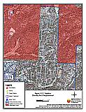
Figure 10-1Community of Stateline |
 |
Table 10-1Stateline Wildfire Hazard Assessment Rating Sheet |
 |
10.2 Chimney Rock Neighborhood Risk And Hazard Assessment
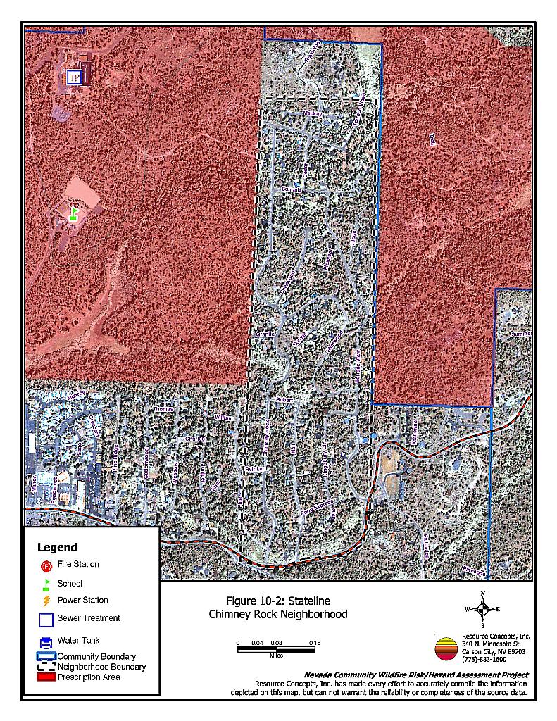
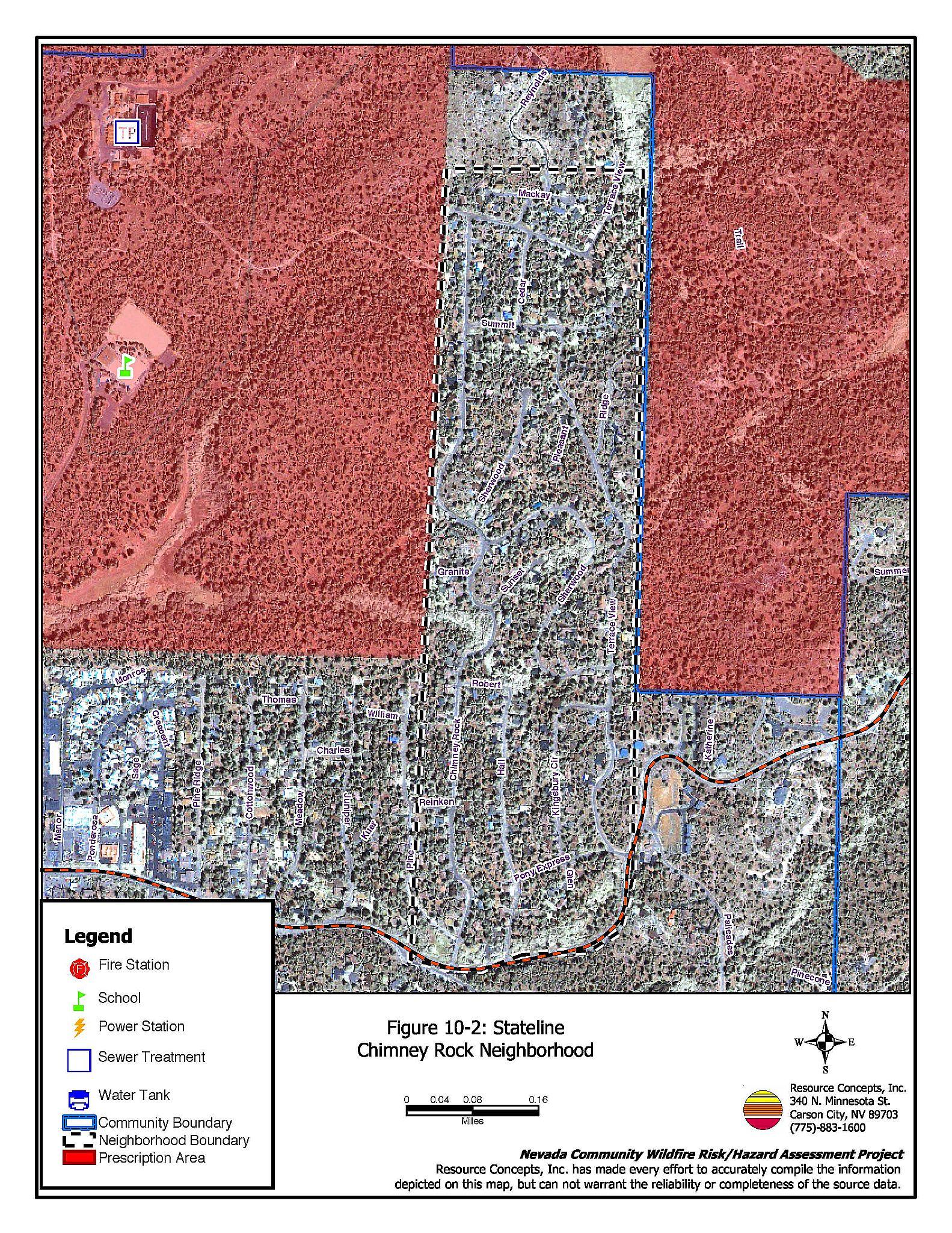
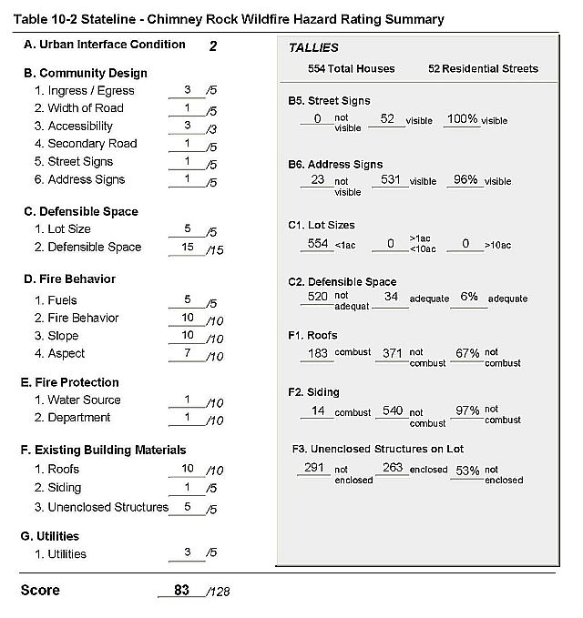
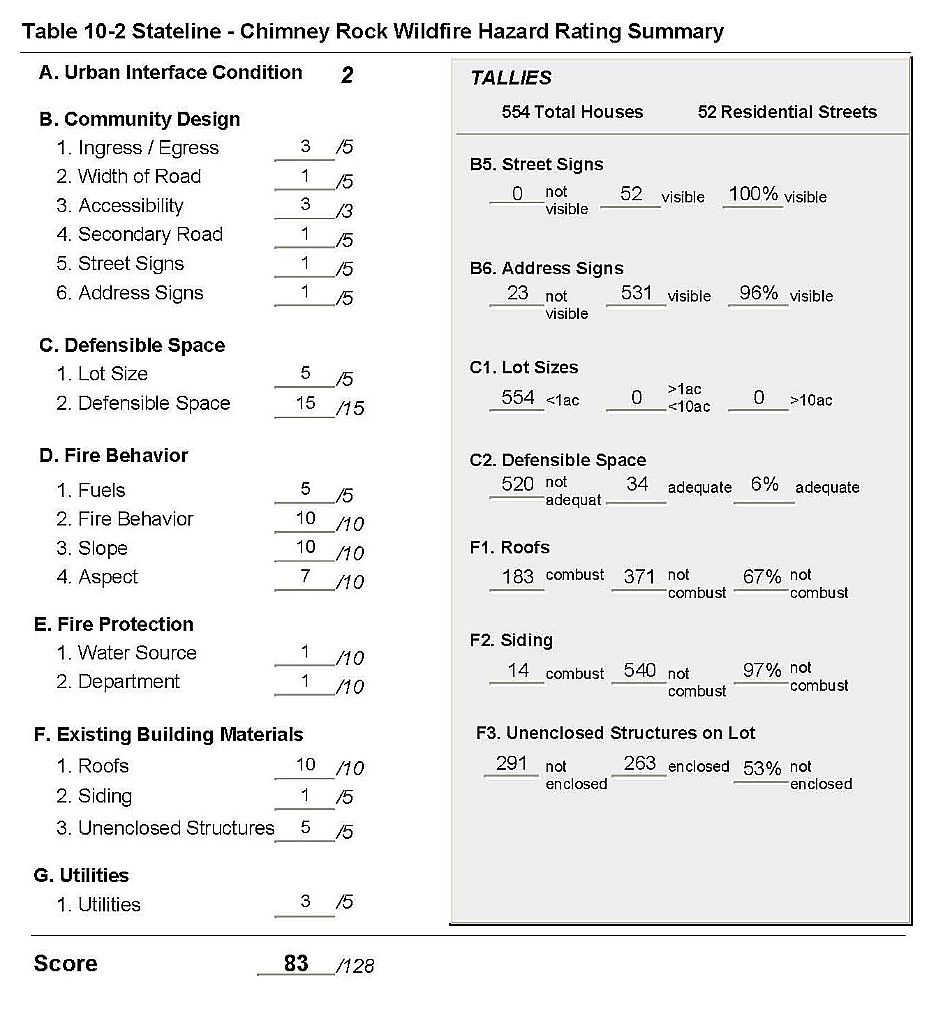
Chimney Rock is located east of Stateline, accessed by Kingsbury Grade (State Route 207). (See Figure 10-2). The community is situated on steep slopes of over 30 percent grade. Narrow canyons and saddles characterize the topography. Vegetation composition is a Jeffery pine and white fire tree layer with an understory shrub component of manzanita and associated shrubs, and thick ground fuels. Overall fuel loading is estimated at six to eight tons per acre. The risk assessment resulted in classifying Chimney Rock in the Extreme Hazard category (83 points). The rating is attributed primarily to inadequate defensible space, a high number of homes with wood shake roofs and unenclosed decks or porches, close residential spacing, and fire behavior factors. The Chimney Rock Hazard Assessment Summary is included as Table 10-2.
10.2.1 Community Design
The urban interface condition surrounding Chimney Rock is classified as an intermix condition. Structures are scattered throughout the wildland area. There is no clear line of demarcation between structures and wildland fuels along roads or back fences. There were 554 single-family residences observed in the assessment area. All of the homes are on lots of one acre or less.
- Roads: Kingsbury Grade is the primary road through Chimney Rock. This is a one-way in/one-way out access issue, posing potential problems for fire suppression vehicles and resident evacuation in the event of a wildfire. The secondary roads are typically steep and winding, although there is adequate turnaround space and room for two-vehicle passage.
- Signage: All of the street signs in Chimney Rock are clearly posted and visible. Ninety-six percent of residential addresses are visible, which will assist firefighters in locating specific homes during poor visibility conditions that may occur during a wildland fire.
10.2.2 Construction Materials
Nearly all (97 percent) of the homes observed during the assessment have non-combustible siding; however, 67 percent of the homes have combustible wood shake roofs. Over half of the homes have unenclosed porches, decks, or balconies. Architectural features such as these and wood shake roofs provide places where flying embers and sparks can lodge and smolder, eventually spreading fire to the home.
10.2.3 Defensible Space
Out of the 554 homes observed in the assessment area, only six percent have adequate defensible space to protect the home during a wildfire. The Tahoe-Douglas FPD regulations require 30 to 100 feet of defensible space, depending on the slope of the terrain surrounding the home. Steeper slopes require more defensible space on the downhill side of lots, because flame lengths are longer on slopes. See Appendix D for defensible space guidelines.
10.2.4 Factors Affecting Fire Behavior
The dominant vegetation layer in Chimney Rock is a tree layer of Jeffery pine with white fir. The shrub understory includes manzanita, snowbrush, bitterbrush, whitethorn, and some sagebrush and rabbitbrush along roads. The ground fuels consist of a heavy layer of pine needles and cones, dead and down woody fuels, and annuals including cheatgrass. Fuel loading overall is estimated at six to eight tons per acre. The community is situated within narrow canyons and saddles, on ridgetops, and steep slopes over 30 percent. Predominant winds come from the west and southwest. The fuel composition, a heavy tree layer with closed canopies and dense understory ladder fuels, is conducive to crown fires in the tree canopy. All of these factors together may reduce fire suppression initial attack effectiveness.
10.2.5 Fire Behavior Worst Case Scenario
A fire that starts west or southwest of the community would be driven upslope by the predominant west and southwest winds, and be fueled by the heavy ground layer. The dense understory would provide ladder fuels and eventually drive the fire into the tree crown. The tree layer is heavily overstocked currently. Closely spaced structures, wood shake roofs, and unenclosed architectural features, all increase the risk of structure loss. Radiant heat from one house can ignite close-by adjacent homes. The closed tree canopy will hold heat under the tree crown, increasing radiant heat and ignition risk to homes. The steep, winding roads would limit access, two-vehicle passage, and evacuation of residents; during a wildfire visibility will be reduces, making access even more difficult.
10.2.6 Risk Assessment
There is a high potential for a wildfire ignition in the Chimney Rock area, and a high potential for structure loss. Topography-related fire behavior factors, combustible and unenclosed construction features, access, and heavy fuel loads all contribute to the high risk of property loss and damage, as well as the potential for loss of life.
10.2.7 Chimney Rock Risk and Hazard Reduction Recommendations, Roles And Responsibilities
The responsibility to keep a community fire safe falls not only on the local fire department but also on the residents of the community, businesses, and local governments. General recommendations related to defensible space, fuel reduction, community preparedness, and public education, are included in Chapter 4. The Stateline Unit 2 and the Kingsbury Unit 4 fuel reduction treatments are adjacent to the Chimney Rock community. The specifications for these treatments are detailed on the project worksheets in Chapter 11.
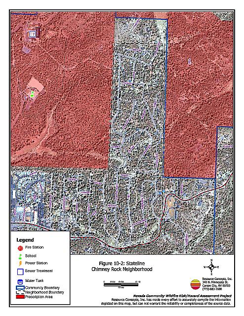
Figure 10-2Stateline - Chimney Rock Neighborhood |
 |
Table 10-2Chimney Rock Wildfire Hazard Assessment Rating Sheet |
 |