![]()
![]()
7.0 Glenbrook
7.1 Risk And Hazard Assessment
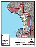
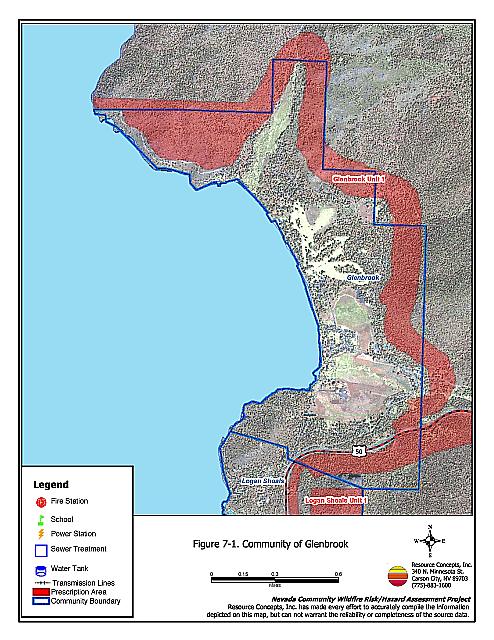
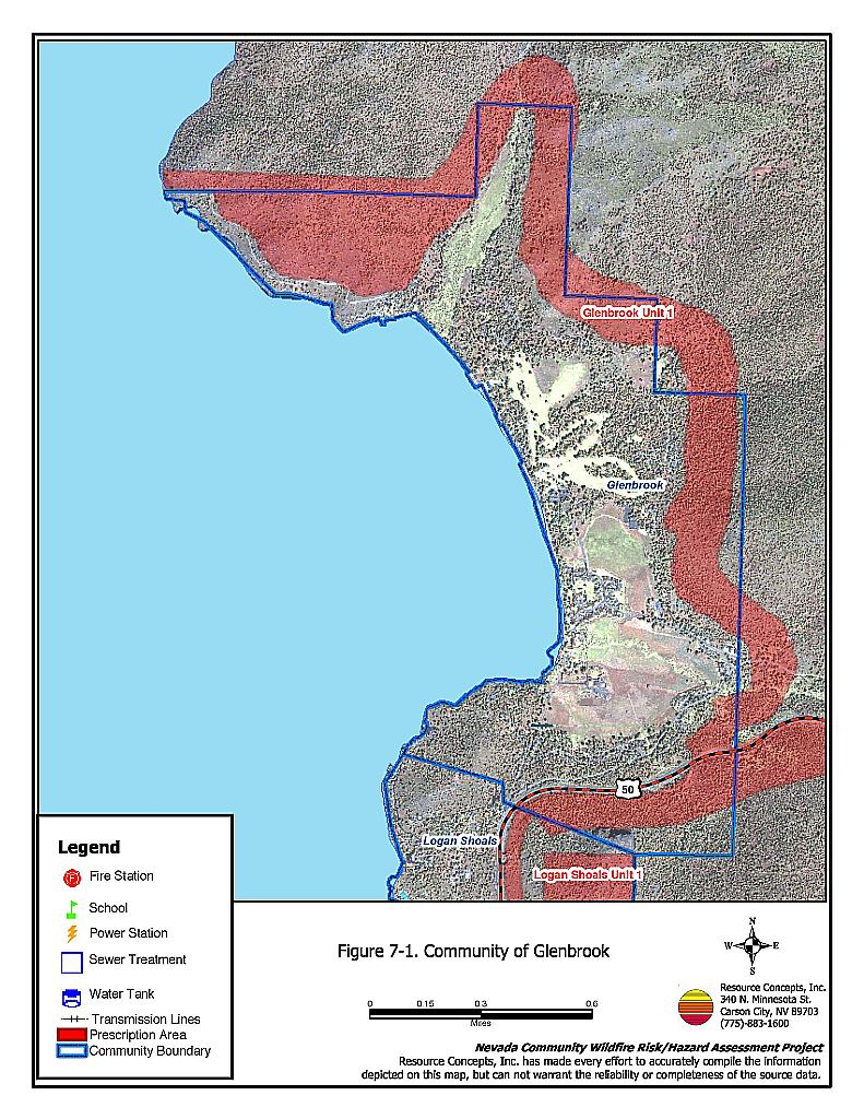
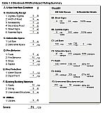
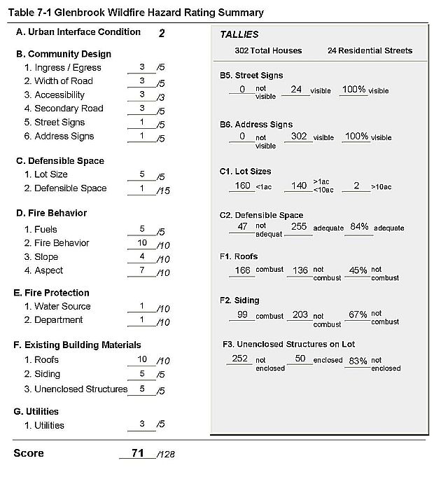
Glenbrook is located off of US Highway 50, above the east shore of Lake Tahoe, and situated around Pray Meadows. Figure 7-1 details the location of the Community in relation to the Lake Tahoe Basin in general. The predominant vegetation is Jeffrey pine with a dense shrub understory and heavy ground fuels. The risk assessment resulted in classifying Glenbrook in the High Hazard category (71 points). The rating is attributed to combustible and unenclosed construction features, close residential spacing, and fire behavior factors. Defensible space is near adequate, which greatly reduces risks and hazards in Glenbrook. The Glenbrook Hazard Assessment Summary is included as Table 7-1.
7.1.1 Community Design
The interface in Glenbrook is considered an intermix condition. Structures are scattered throughout the area, directly within wildland fuels, with no clear line of demarcation between structures and fuels. There were 302 homes observed during the assessment, with about half on lots of one acre or less, and the other half on lots of between one and ten acres.
- Roads: Old Highway 50 leads into the community from US Highway 50. All of the roads in Glenbrook are narrow and winding, and some are very steep. During a wildfire steep, narrow roads reduce the ability of fire suppression equipment to maneuver, or for two-vehicle passage if residents are evacuating the area at the same time fire fighters are trying to get in.
- Signage: All of the street signs in Glenbrook are clearly posted and visible, as are the address signs. This will help fire suppression personnel to locate specific at-risk areas or homes during a wildfire.
7.1.2 Construction Materials
Approximately 67 percent of the homes in Glenbrook are constructed of non-combustible siding. Less than half, 45 percent, have non-combustible roof material such as tile, metal, or composition. The majority of homes, 83 percent, have unenclosed decks, porches or balconies. Unenclosed architectural features and wood shake roofs provide areas where flying embers can lodge and smolder, eventually spreading fire to the home.
7.1.3 Defensible Space
More than three-quarters of the residences (84%) have adequate defensible space to protect the home in the event of a wildfire. Tahoe-Douglas FPD regulations require 30 to 100 feet of defensible space, depending on the slope of the terrain surrounding the home. Steeper slopes require more defensible space on the downhill side of lots, because flame lengths are longer on slopes. See Appendix D for the Tahoe Basin Fire Protection Districts Defensible Space and Thinning Guidelines.
7.1.4 Factors Affecting Fire Behavior
Vegetation in Glenbrook consists of a dominant tree layer of Jeffery pine and white fir, with some incense cedar. Aspen, willow, and mountain alder occupy the stream zones. The understory shrub layer is composed of manzanita, bitterbrush, and snowbrush, and rabbitbrush. The ground fuel is a heavy duff layer of pine needles and cones, dead and down woody fuels, and annuals including cheatgrass.
7.1.5 Fire Behavior Worst Case Scenario
The worst-case scenario in Glenbrook would be a major structure fire that vents into the tree canopy becoming a crown fire. The closed canopy would hold heat in, allowing radiant heat to ignite other homes. Homes spaced close together and homes situated in stands of trees would be at risk of ignition as well, and the number of wood shake roofs and unenclosed architectural features adds to the risk. Narrow, winding roads pose a dangerous situation for residents trying to leave in case of fire and fire fighters trying to get into the neighborhood. Visibility would be significantly reduced in a fire, making two-vehicle passage hazardous. There are no safety zones on the road
7.1.6 Risk Assessment
Glenbrook has a high potential for both ignition and structure loss. Steep, narrow and winding roads, combustible construction materials, close home spacing, a closed tree canopy with a dense understory component, all contribute to the risk and associated hazards.
7.2 Risk and Hazard Reduction Recommendations, Roles And Responsibilities
The responsibility to keep a community fire safe falls not only on the local fire department but also on the residents of the community, businesses, and local governments. Glenbrook has shown great progress toward community safety through membership as a chapter of the Nevada Fire Safe Council. Although some progress has been made toward fuel reduction, the general recommendations related to defensible space, fuel reduction, community preparedness, and public education, included in Chapter 4.0, are provided for those landowners who have not yet completed treating their private property. One fuelbreak-fuel reduction treatment of approximately 400 acres is recommended for the Glenbrook community. Project details are specified on the project worksheet in Chapter 11.
Figure 7-1Community of Glenbrook |
 |
Table 7-1Glenbrook Wildfire Hazard Assessment Rating Sheet |
 |